ATL: MILTON - Post-Tropical - Discussion

Moderator: S2k Moderators

Message
Author
User avatar
StPeteMike
Category 2
Category 2
Posts: 633
Joined: Thu Jun 07, 2018 11:26 pm

Re: ATL: MILTON - Hurricane - Discussion: 165 mph / 902 mbs

#3821 Postby StPeteMike » Tue Oct 08, 2024 7:23 pm

Pas_Bon wrote:Is Tampa/St Pete a ghost town now? Trying to see what it’s like there

Pretty much. There’s a few businesses still open but the majority of downtown is dead besides a few residents walking around.

Tomorrow will be even quieter.
2 likes   
The above post is not official and should not be used as such. It is the opinion of the poster and may or may not be backed by sound meteorological data. It is not endorsed by any professional institution or storm2k.org. For official information, please refer to the NHC and NWS products.

User avatar
Steve
S2K Supporter
S2K Supporter
Posts: 9623
Joined: Sat Apr 05, 2003 11:41 pm
Location: Not a state-caster

Re: ATL: MILTON - Hurricane - Discussion: 165 mph / 902 mbs

#3822 Postby Steve » Tue Oct 08, 2024 7:24 pm

kassi wrote:
eastcoastFL wrote:The Mayor of Tampa regarding Evacuations

When asked about what she would say to residents who’ve ridden out past hurricanes and are hesitant about evacuating for Milton, Castor gave a grave warning.

“Helene was a wake-up call. This is literally catastrophic, and I can say without any dramatization whatsoever: If you choose to stay in one of those evacuation areas, you are going to die,” Castor warned.

While it's definitely a possibility, and I do believe everyone should heed mandatory evacuations, I do not agree with her approach.


Maybe you cling to a tree? It’s part of a larger appearance that didn’t make political points or jabs at the spreaders of obvious disinformation - just a reminder that the internet is full of bs. Nina Golgowski on Yahoo News has the story, but I’m not linking it because it names names. However, I will copy and paste this from Mayor Castor:

“Please don’t get political on this. This storm is going to affect everybody, and we are getting the help that we need from all of the different governmental officials,” Tampa Mayor Jane Castor said at a press conference Tuesday…“Hate to break it to you but a lot of what you see on social media is not factual. Stick with the facts,” Castor said, after dispelling localized rumors that Tampa is proactively shutting off power and water to all residents before the storm hits.
Last edited by Steve on Tue Oct 08, 2024 7:28 pm, edited 2 times in total.
4 likes   

utweather
Category 1
Category 1
Posts: 252
Joined: Tue Jan 26, 2010 10:51 pm
Location: SE Austin, TX

Re: ATL: MILTON - Hurricane - Discussion: 165 mph / 902 mbs

#3823 Postby utweather » Tue Oct 08, 2024 7:25 pm

FLLurker32 wrote:Timing of the NE heading will make a huge difference on where this ends up. I accidentally took an unheard of evening nap. Time to wobble watch and read comments claiming new landfall points all night. :spam:


A tv met in the area expect it will trend even further south. Same reasoning as the pro met here.
0 likes   

User avatar
johngaltfla
Category 5
Category 5
Posts: 2069
Joined: Sun Jul 10, 2005 9:17 pm
Location: Sarasota County, FL
Contact:

Re: ATL: MILTON - Hurricane - Discussion: 165 mph / 902 mbs

#3824 Postby johngaltfla » Tue Oct 08, 2024 7:26 pm

caneman wrote:Still west of track for 4 hours now looks like Longboat key


I wouldn't be shocked to see landfall anywhere between Lido Key and Anna Maria Island. It's going to be a historic disaster no matter what.
1 likes   

User avatar
tropicwatch
Category 5
Category 5
Posts: 3391
Age: 61
Joined: Sat Jun 02, 2007 10:01 am
Location: Panama City Florida
Contact:

Re: ATL: MILTON - Hurricane - Discussion: 165 mph / 902 mbs

#3825 Postby tropicwatch » Tue Oct 08, 2024 7:27 pm

Spaghetti Model tracks south of Tampa.

Image
1 likes   
Tropicwatch


Agnes 72', Eloise 75, Elena 85', Kate 85', Charley 86', Florence 88', Beryl 94', Dean 95', Erin 95', Opal 95', Earl 98', Georges 98', Ivan 2004', Arlene 2005', Dennis 2005', Ida 2009' Debby 2012' Irma 2017' Michael 2018'

wx98
Category 5
Category 5
Posts: 1383
Joined: Sat Aug 25, 2018 9:24 pm

Re: ATL: MILTON - Hurricane - Discussion: 165 mph / 902 mbs

#3826 Postby wx98 » Tue Oct 08, 2024 7:27 pm

Current Intensity Analysis


UW - CIMSS
ADVANCED DVORAK TECHNIQUE
ADT-Version 9.1
Tropical Cyclone Intensity Algorithm

----- Current Analysis -----
Date : 08 OCT 2024 Time : 234020 UTC
Lat : 22:57:35 N Lon : 86:56:24 W


CI# /Pressure/ Vmax
7.6 / 900.3mb/158.0kt


Final T# Adj T# Raw T#
7.5 7.5 7.5

Estimated radius of max. wind based on IR :N/A km

Center Temp : +12.5C Cloud Region Temp : -76.4C

Scene Type : EYE

Subtropical Adjustment : OFF

Extratropical Adjustment : OFF

Positioning Method : ARCHER POSITIONING

Ocean Basin : ATLANTIC
Dvorak CI > MSLP Conversion Used : CKZ Method

Tno/CI Rules : Constraint Limits : NO LIMIT
Weakening Flag : ON
Rapid Dissipation Flag : OFF
4 likes   

Rail Dawg
S2K Supporter
S2K Supporter
Posts: 326
Joined: Mon Aug 27, 2012 5:02 pm
Location: Where the eye makes landfall.

Re: ATL: MILTON - Hurricane - Discussion: 165 mph / 902 mbs

#3827 Postby Rail Dawg » Tue Oct 08, 2024 7:27 pm

Started chasing Cat 1 and 2 in Louisiana mid-90's.

Great way to cut one's teeth.

Finally got to the 4's and then finally the Cat 5.

Parking lot garages are where it's at. Both vehicle and supplies are safe from both wind and surge.

It takes planning and this board was instrumental during the biggest storms.

So the fun for 25 years and 16 storms was to try and catch the eye of the hurricane while in a parking lot garage.

These newbies are going to pay a very high misery price if they decide to chase a Cat 5 without much experience.

It's a very deadly game. You Tube Mexico Beach car washed away Michael. Those are the 2 kids warned not to leave the parking garage in Panama City as we learned it was now a Cat 5.

Their desire for online clicks cost them their vehicle, supplies and almost their lives.

One rule in chasing is don't become a liability.

Chuck
15 likes   
Although I have been a hurricane forecaster since 1980 that only means I've been wrong lots of times.

dukeblue219
S2K Supporter
S2K Supporter
Posts: 535
Joined: Fri Sep 30, 2016 3:52 pm

Re: ATL: MILTON - Hurricane - Discussion: 165 mph / 902 mbs

#3828 Postby dukeblue219 » Tue Oct 08, 2024 7:29 pm

tropicwatch wrote:Spaghetti Model tracks south of Tampa.

https://tropicwatch.info/spaghetti100820240000z.png

Ugh. There are some real junky models in that bunch including what looks like a projection of the current path straight through the keys which just ain't gonna happen.
5 likes   

User avatar
Blown Away
S2K Supporter
S2K Supporter
Posts: 10153
Joined: Wed May 26, 2004 6:17 am

Re: ATL: MILTON - Hurricane - Discussion: 165 mph / 902 mbs

#3829 Postby Blown Away » Tue Oct 08, 2024 7:30 pm

johngaltfla wrote:
caneman wrote:Still west of track for 4 hours now looks like Longboat key


I wouldn't be shocked to see landfall anywhere between Lido Key and Anna Maria Island. It's going to be a historic disaster no matter what.


Image

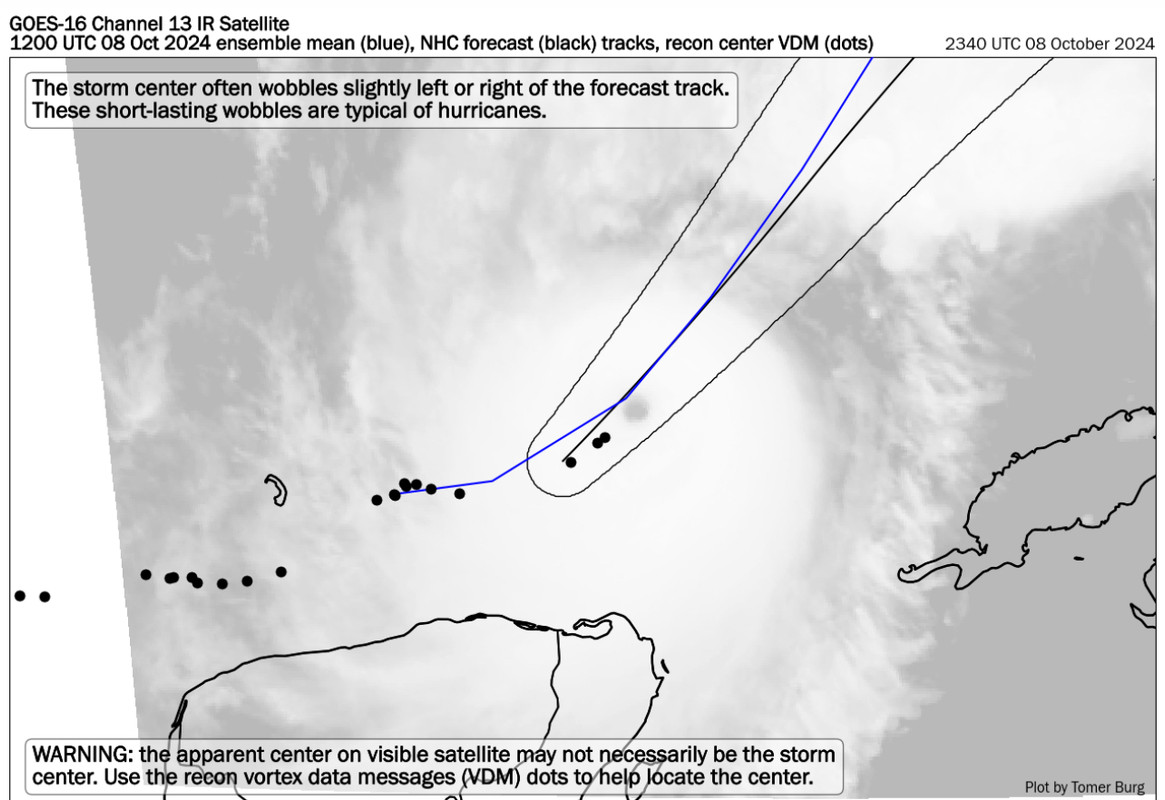
Milton is already east of the 5pm track… Not west.
4 likes   
Hurricane Eye Experience: David 79, Irene 99, Frances 04, Jeanne 04, Wilma 05… Hurricane Brush Experience: Andrew 92, Erin 95, Floyd 99, Matthew 16, Irma 17, Ian 22, Nicole 22…

User avatar
NDG
S2K Supporter
S2K Supporter
Posts: 15448
Joined: Sun Jul 09, 2006 10:14 pm
Location: Orlando, FL

Re: ATL: MILTON - Hurricane - Discussion: 165 mph / 902 mbs

#3830 Postby NDG » Tue Oct 08, 2024 7:30 pm

Eye keeps contracting, down to 8 nm.

511
URNT12 KNHC 090018
VORTEX DATA MESSAGE AL142024
A. 08/23:51:00Z
B. 23.02 deg N 086.90 deg W
C. 700 mb 2319 m
D. EXTRAP 907 mb
E. NA
F. CLOSED
G. C8
H. 133 kt
I. 142 deg 5 nm 23:49:30Z
J. 235 deg 142 kt
K. 146 deg 6 nm 23:49:00Z
L. 143 kt
M. 343 deg 3 nm 23:52:00Z
N. 061 deg 122 kt
O. 331 deg 7 nm 23:53:00Z
P. 11 C / 3031 m
Q. 23 C / 3045 m
R. 11 C / NA
S. 12345 / 7
T. 0.02 / 1 nm
U. AF303 1614A MILTON OB 19
MAX FL WIND 156 KT 207 / 7 NM 22:26:00Z
SLP EXTRAP FROM 700 MB
;
1 likes   

wx98
Category 5
Category 5
Posts: 1383
Joined: Sat Aug 25, 2018 9:24 pm

Re: ATL: MILTON - Hurricane - Discussion: 165 mph / 902 mbs

#3831 Postby wx98 » Tue Oct 08, 2024 7:32 pm

Mike Bettes on TWC just threw out the “A-word”…

Annular :double:
1 likes   

User avatar
Highteeld
Category 5
Category 5
Posts: 2139
Age: 41
Joined: Tue Jan 30, 2018 9:10 pm
Location: Chicago

Re: ATL: MILTON - Hurricane - Discussion: 165 mph / 902 mbs

#3832 Postby Highteeld » Tue Oct 08, 2024 7:32 pm

ERC is happening soon. I think the peak today was probably around 21 zulu
1 likes   
Very useful information on the Dvorak Technique --

https://severe.worldweather.wmo.int/TCF ... kBeven.pdf

SconnieCane
Category 4
Category 4
Posts: 999
Joined: Thu Aug 02, 2018 5:29 pm
Location: Madison, WI

Re: ATL: MILTON - Hurricane - Discussion: 165 mph / 902 mbs

#3833 Postby SconnieCane » Tue Oct 08, 2024 7:34 pm

wx98 wrote:Mike Bettes on TWC just threw out the “A-word”…

Annular :double:


Properly annular TCs have a much larger eye than Milton ever has thus far. See the examples pictured here.
Last edited by SconnieCane on Tue Oct 08, 2024 7:34 pm, edited 1 time in total.
2 likes   

User avatar
eastcoastFL
Category 5
Category 5
Posts: 3900
Age: 43
Joined: Thu Apr 12, 2007 12:29 pm
Location: Palm City, FL

Re: ATL: MILTON - Hurricane - Discussion: 165 mph / 902 mbs

#3834 Postby eastcoastFL » Tue Oct 08, 2024 7:34 pm

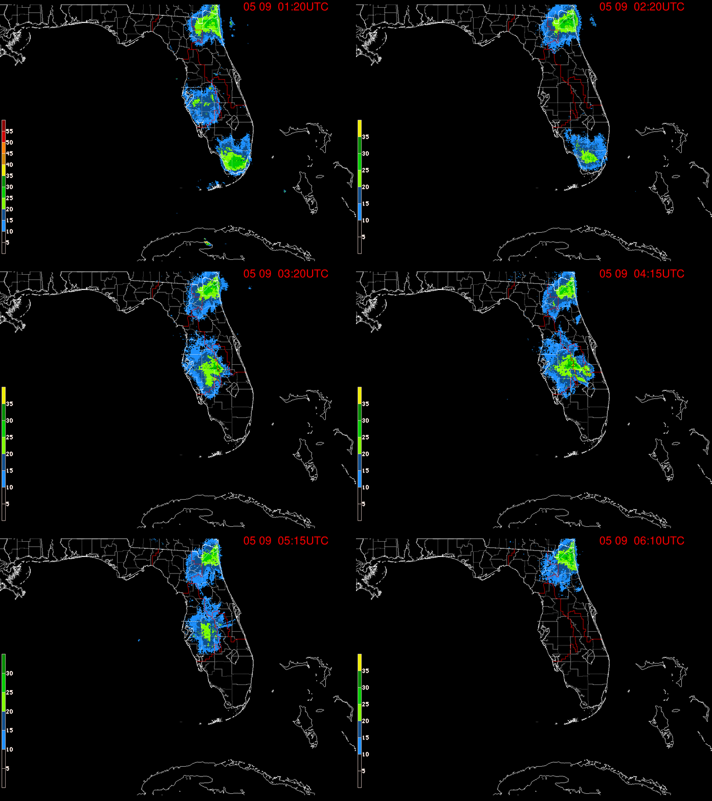
The incoming rain is following the nhc track

Image
5 likes   
Personal Forecast Disclaimer:
The posts in this forum are NOT official forecast and should not be used as such. They are just the opinion of the poster and may or may not be backed by sound meteorological data. They are NOT endorsed by any professional institution or storm2k.org. For official information, please refer to the NHC and NWS products.

User avatar
NDG
S2K Supporter
S2K Supporter
Posts: 15448
Joined: Sun Jul 09, 2006 10:14 pm
Location: Orlando, FL

Re: ATL: MILTON - Hurricane - Discussion: 165 mph / 902 mbs

#3835 Postby NDG » Tue Oct 08, 2024 7:34 pm

tropicwatch wrote:Spaghetti Model tracks south of Tampa.

https://tropicwatch.info/spaghetti100820240000z.png


Are these the new 0z ?
0 likes   

User avatar
CronkPSU
S2K Supporter
S2K Supporter
Posts: 2014
Joined: Sun Aug 07, 2005 10:44 pm
Location: Avalon Park, FL

Re: ATL: MILTON - Hurricane - Discussion: 165 mph / 902 mbs

#3836 Postby CronkPSU » Tue Oct 08, 2024 7:35 pm

not sure it can complete another EWRC and not lose a lot especially in less ideal conditions...i was always hoping this would be the reason it weakened and not shear
0 likes   
Just like Jon Snow..."I know nothing" except what I know, and most of what I know is gathered by the fine people of the NHC

wx98
Category 5
Category 5
Posts: 1383
Joined: Sat Aug 25, 2018 9:24 pm

Re: ATL: MILTON - Hurricane - Discussion: 165 mph / 902 mbs

#3837 Postby wx98 » Tue Oct 08, 2024 7:35 pm

SconnieCane wrote:
wx98 wrote:Mike Bettes on TWC just threw out the “A-word”…

Annular :double:


Properly annular TCs have a much larger eye than Milton ever has thus far. See the examples pictured here.


Yes, I’m aware. Just thought it slightly humorous because of all the “annular” comments when get in this forum. It is on the Storm2K bingo card after all…
3 likes   

User avatar
NDG
S2K Supporter
S2K Supporter
Posts: 15448
Joined: Sun Jul 09, 2006 10:14 pm
Location: Orlando, FL

Re: ATL: MILTON - Hurricane - Discussion: 165 mph / 902 mbs

#3838 Postby NDG » Tue Oct 08, 2024 7:36 pm

eastcoastFL wrote:The incoming rain is following the nhc track

https://apps.sfwmd.gov/sfwmd/common/images/weather/noaaport/radar_flanim.gif


Wow! Look at those cells offshore, they probably have water spouts.
3 likes   

SconnieCane
Category 4
Category 4
Posts: 999
Joined: Thu Aug 02, 2018 5:29 pm
Location: Madison, WI

Re: ATL: MILTON - Hurricane - Discussion: 165 mph / 902 mbs

#3839 Postby SconnieCane » Tue Oct 08, 2024 7:36 pm

NDG wrote:
tropicwatch wrote:Spaghetti Model tracks south of Tampa.

https://tropicwatch.info/spaghetti100820240000z.png


Are these the new 0z ?


It's only 0035Z, highly unlikely any data from those is available yet. Usually takes a couple hours for it to start populating on sites like TT. I suppose it could be the "early" track projections, but aren't those just interpolated using the previous run?
1 likes   

User avatar
Steve
S2K Supporter
S2K Supporter
Posts: 9623
Joined: Sat Apr 05, 2003 11:41 pm
Location: Not a state-caster

Re: ATL: MILTON - Hurricane - Discussion: 165 mph / 902 mbs

#3840 Postby Steve » Tue Oct 08, 2024 7:40 pm

eastcoastFL wrote:The incoming rain is following the nhc track

https://apps.sfwmd.gov/sfwmd/common/images/weather/noaaport/radar_flanim.gif


Look at those supercells out front. HWRF showed them yesterday on shore.
0 likes   


Return to “2024”

Who is online

Users browsing this forum: No registered users and 6 guests