Poonwalker wrote:weeniepatrol wrote:This is becoming extremely uncomfortable. From the last discussion.. six hours ago:INIT 02/2100Z 21.4N 78.3W 25 KT 30 MPH...POTENTIAL TROP CYCLONE
12H 03/0600Z 22.4N 80.1W 25 KT 30 MPH...POTENTIAL TROP CYCLONE
24H 03/1800Z 24.2N 82.2W 30 KT 35 MPH...TROPICAL CYCLONESlow development is possible while the system is over Cuba, and the system is likely to become a tropical depression soon after it moves offshore on Saturday.
Just six hours ago this was forecast to become a depression AFTER emergence into the Gulf, around 18 zulu tomorrow. In other words, this is a whopping ~18 hours ahead of schedule.. AND as the new discussion mentioned with the west shift will have even MORE time over the 86-90 F waters of the Gulf of Mexico than initially forecast. This is very serious.
The biggest factor I was worried about was the location being over water. It simply consolidated south over the most favorable environment. Hopefully passage over Cuba will prevent any RI in the short term. I don’t trust anything organized coming into the gulf with those record water temps ahead and low shear. In the long term there might be some shear and dry air that caps it before landfall as Levi pointed out.
The issue with that is:
1. We've seen systems not be disrupted whatsoever by passage over western Cuba time and time again, such as Ian.
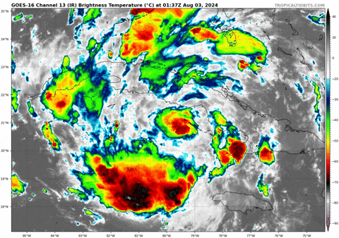
2. In Levi's video, look at what ECMWF shows. 1007mb Sunday afternoon? At this rate this will be 1007mb within 12 hours