ATL: MILTON - Post-Tropical - Discussion

Moderator: S2k Moderators

Message
Author
User avatar
kevin
Category 5
Category 5
Posts: 2587
Age: 26
Joined: Wed Aug 28, 2019 4:35 am

Re: ATL: MILTON - Hurricane - Discussion

#4101 Postby kevin » Wed Oct 09, 2024 3:34 am

153 kt FL wind and 910.1 mb extrapolated with 22 kt winds -> 908 mb. Dropsonde might be a bit higher than that based on the bias so far so I expect 910mb/140kt at 5am.
0 likes   

User avatar
Bocadude85
Category 5
Category 5
Posts: 2991
Age: 38
Joined: Mon Apr 18, 2005 2:20 pm
Location: Honolulu,Hi

Re: ATL: MILTON - Hurricane - Discussion

#4102 Postby Bocadude85 » Wed Oct 09, 2024 3:34 am

jdjaguar wrote:
Bocadude85 wrote:
jdjaguar wrote:look at the 2am update


The NHC does not release new tracks on intermediate advisories. All they do is update the position.

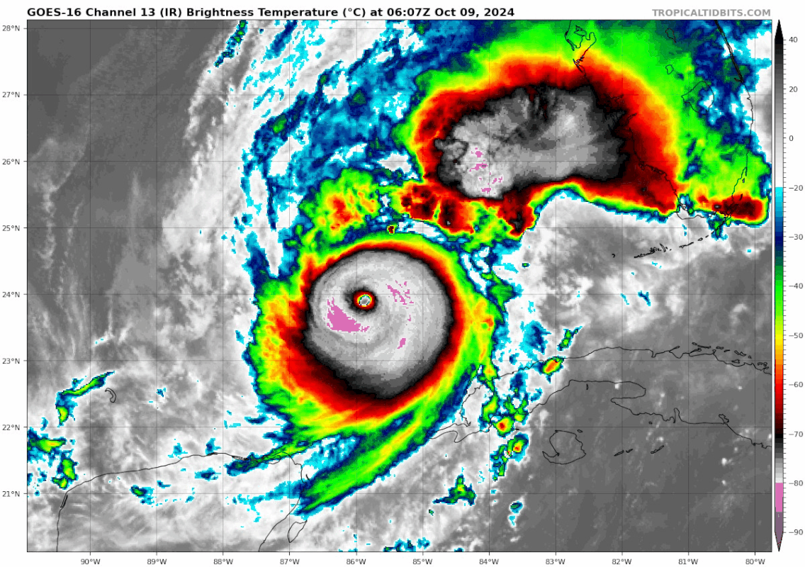
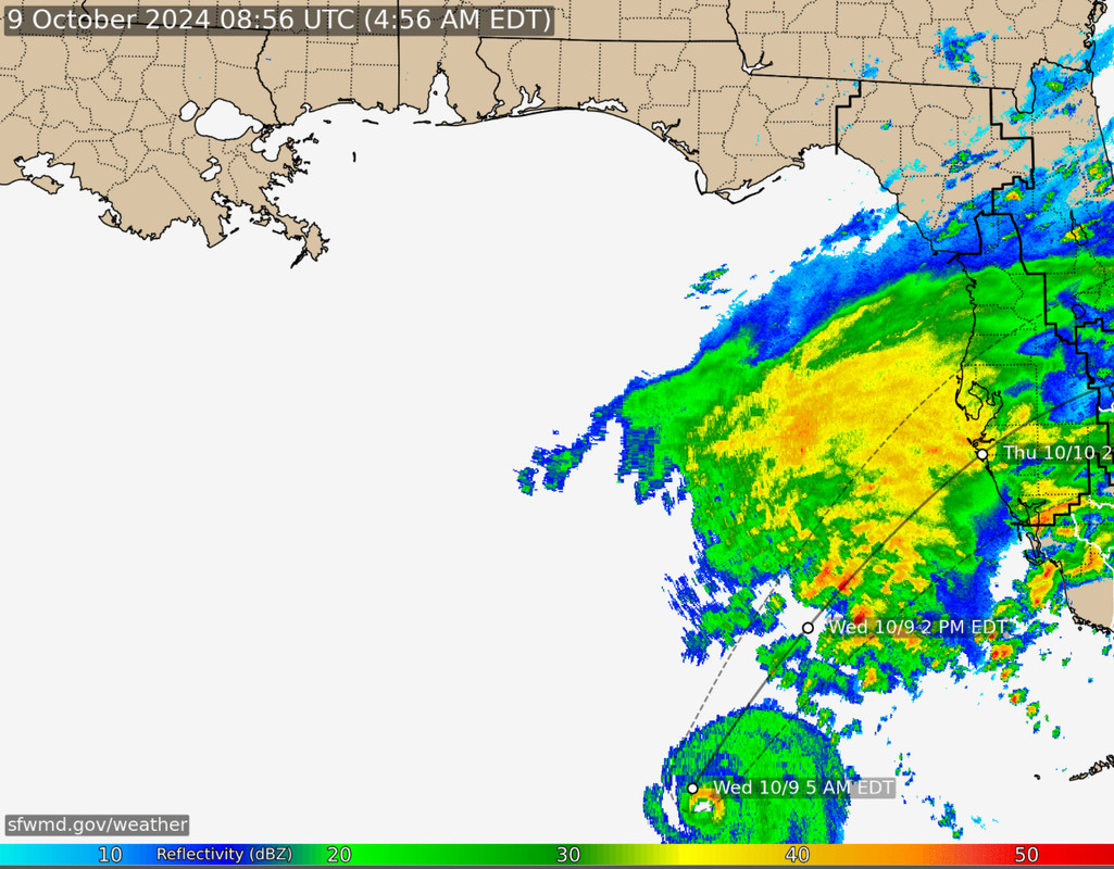
Speaking of which Milton is still running east of the 11pm track

https://www.wfla.com/weather/tracking-the-tropics/live-wobble-tracker-changes-in-hurricane-miltons-path-could-have-huge-impacts/

The NHC adjusts the cone at each advisory.
Which they did at the 1am intermediate advisory.
This adjustment in the graphic was a nudge north.


This is incorrect. The NHC releases updated tracks 4 times a day. 5am,11am,5pm,and 11pm eastern time. The only thing you see on the cone during intermediate advisories is the updated position which can make it look like the cone has changed when in fact it has not.
Last edited by Bocadude85 on Wed Oct 09, 2024 3:38 am, edited 1 time in total.
4 likes   

jhpigott
Category 2
Category 2
Posts: 570
Joined: Wed Jan 02, 2008 8:09 pm
Location: North Palm Beach, Florida

Re: ATL: MILTON - Hurricane - Discussion

#4103 Postby jhpigott » Wed Oct 09, 2024 3:35 am

GCANE wrote:Milton is about 25 miles east of forecast track.

No sign shear has any effect.

Eye is 8 nm wide.

Latest eyedrop indicates no forthcoming EWRC.

Well into the Loop Current now.

CAPE in SE section of GoM is slowly increasing.

Ionospheric heating has turned back up. Currently over the Mid East


Interested to see what the NHC does with the track. This radar loop and track overlay speak for themselves. Comfortably east of the forecast track like GCANE mentioned and early to the next forecast point

https://www.sfwmd.gov/weather-radar/cur ... conditions
2 likes   

User avatar
GCANE
S2K Supporter
S2K Supporter
Posts: 11501
Joined: Mon Oct 22, 2007 8:03 am

Re: ATL: MILTON - Hurricane - Discussion

#4104 Postby GCANE » Wed Oct 09, 2024 3:41 am

Looks like the radius of max winds has increased over a 24-hr period.
0 likes   

caneman
Category 5
Category 5
Posts: 1447
Joined: Fri Sep 05, 2014 5:44 am
Location: Clearwater Beach, Fl

Re: ATL: MILTON - Hurricane - Discussion

#4105 Postby caneman » Wed Oct 09, 2024 3:42 am

Unless it starts to track back Northerly this could go as far south as Venice.
0 likes   

User avatar
Blown Away
S2K Supporter
S2K Supporter
Posts: 10152
Joined: Wed May 26, 2004 6:17 am

Re: ATL: MILTON - Hurricane - Discussion

#4106 Postby Blown Away » Wed Oct 09, 2024 3:43 am

Image

INIT 09/0300Z 23.4N 86.5W 140 KT 160 MPH
12H 09/1200Z 24.7N 85.3W 135 KT 155 MPH


Milton looks it’s going to be well E of the predicted 12z position… Maybe starting to get squeezed on W side, hopefully downtrend from here with intensity, hopefully!
3 likes   
Hurricane Eye Experience: David 79, Irene 99, Frances 04, Jeanne 04, Wilma 05... EYE COMING MY WAY IN 2024…
Hurricane Brush Experience: Andrew 92, Erin 95, Floyd 99, Matthew 16, Irma 17, Ian 22, Nicole 22…

User avatar
kevin
Category 5
Category 5
Posts: 2587
Age: 26
Joined: Wed Aug 28, 2019 4:35 am

Re: ATL: MILTON - Hurricane - Discussion

#4107 Postby kevin » Wed Oct 09, 2024 3:48 am

Current location on IR floater is 24.36N, 85.37W (08:40z). The location at 05:29z was 23.75N, -85.95W according to ARCHER. This indicates an average forward speed of 11 mph and a bearing of 41 degrees east of north aka NE (ever so slightly NNE) over the last 3 hours.
1 likes   

User avatar
GCANE
S2K Supporter
S2K Supporter
Posts: 11501
Joined: Mon Oct 22, 2007 8:03 am

Re: ATL: MILTON - Hurricane - Discussion

#4108 Postby GCANE » Wed Oct 09, 2024 3:52 am

Starting to see a PVS signature in the N GoM from the trof.

https://tropic.ssec.wisc.edu/real-time/ ... oom=&time=

Could be good or bad.'
Could impart shear and weaken Milton and / or could initiate extratropical transition and bring tornadoes and heavier rain, more than expected, for mid FL.
Last couple days, GFS has been showing the trof going negative tilt as it interacts with Milton.
1 likes   

caneman
Category 5
Category 5
Posts: 1447
Joined: Fri Sep 05, 2014 5:44 am
Location: Clearwater Beach, Fl

Re: ATL: MILTON - Hurricane - Discussion

#4109 Postby caneman » Wed Oct 09, 2024 3:53 am

kevin wrote:Current location on IR floater is 24.36N, 85.37W (08:40z). The location at 05:29z was 23.75N, -85.95W according to ARCHER. This indicates an average forward speed of 11 mph and a bearing of 41 degrees east of north aka NE (ever so slightly NNE) over the last 3 hours.


That might nudge it a little further North at landfall. We'll see
0 likes   

User avatar
GCANE
S2K Supporter
S2K Supporter
Posts: 11501
Joined: Mon Oct 22, 2007 8:03 am

Re: ATL: MILTON - Hurricane - Discussion

#4110 Postby GCANE » Wed Oct 09, 2024 3:56 am

Awesome

Recon just reported an inner and outer eyewall

Inner Eye Diameter: 8 nautical miles (9 statute miles)
Outer Eye Diameter: 32 nautical miles (37 statute miles)
2 likes   

User avatar
kevin
Category 5
Category 5
Posts: 2587
Age: 26
Joined: Wed Aug 28, 2019 4:35 am

Re: ATL: MILTON - Hurricane - Discussion

#4111 Postby kevin » Wed Oct 09, 2024 3:57 am

5am discussion excerpts. Initial intensity is set at 907mb/140kt.

The NHC track forecast is nudged a
little to the north of the previous one to be in better agreement
with the latest models. It should be noted that this forecast is
based on the model fields, not the interpolated models which
appear to be too far south. Users are urged not to focus on the
exact landfall point as the average error at 24 hours is about 40
miles.


INIT 09/0900Z 24.5N 85.4W 140 KT 160 MPH
12H 09/1800Z 25.9N 84.3W 130 KT 150 MPH
24H 10/0600Z 27.4N 82.6W 115 KT 130 MPH...NEAR THE COAST
36H 10/1800Z 28.2N 80.5W 70 KT 80 MPH...OVER WATER
0 likes   

caneman
Category 5
Category 5
Posts: 1447
Joined: Fri Sep 05, 2014 5:44 am
Location: Clearwater Beach, Fl

Re: ATL: MILTON - Hurricane - Discussion

#4112 Postby caneman » Wed Oct 09, 2024 4:03 am

Between Anna Maria Island and Bradenton tracking along the eastern edge of Tampa Bay? Edit. Closer to Longboat key
Last edited by caneman on Wed Oct 09, 2024 4:04 am, edited 1 time in total.
1 likes   

User avatar
chris_fit
Category 5
Category 5
Posts: 3222
Age: 42
Joined: Wed Sep 10, 2003 11:58 pm
Location: Tampa Bay Area, FL

Re: ATL: MILTON - Hurricane - Discussion

#4113 Postby chris_fit » Wed Oct 09, 2024 4:03 am

Was not expecting them to nudge the track north with what appears to be clearly a more eastward component.
0 likes   

User avatar
robbielyn
Category 5
Category 5
Posts: 1298
Joined: Wed May 07, 2003 9:45 am
Location: brooksville, fl

Re: ATL: MILTON - Hurricane - Discussion

#4114 Postby robbielyn » Wed Oct 09, 2024 4:04 am

kevin wrote:Still tracking east of the forecast, but models (which seem to have initialized correctly) either stay put at TB or move north... I don't know what to do with this information. The next 24 hours are gonna be the nailbiter of the century in terms of hurricane tracking.

https://i.imgur.com/jotkzt2.png

This is the time to watch what the storm is actually doing vs models. they hv a mind of their own. nhc track probably right since storm is r of track
Last edited by robbielyn on Wed Oct 09, 2024 4:58 am, edited 1 time in total.
1 likes   
Robbielyn McCrary
I know just about enough to sound like I know what I'm talking about sometimes. But for your safety please follow the nhc for truly professional forecasting. :D

User avatar
Blown Away
S2K Supporter
S2K Supporter
Posts: 10152
Joined: Wed May 26, 2004 6:17 am

Re: ATL: MILTON - Hurricane - Discussion

#4115 Postby Blown Away » Wed Oct 09, 2024 4:04 am

Image

As of 5:01 am, Milton already E of the 5:00 am track…. :lol: :lol:
5 likes   
Hurricane Eye Experience: David 79, Irene 99, Frances 04, Jeanne 04, Wilma 05... EYE COMING MY WAY IN 2024…
Hurricane Brush Experience: Andrew 92, Erin 95, Floyd 99, Matthew 16, Irma 17, Ian 22, Nicole 22…

caneman
Category 5
Category 5
Posts: 1447
Joined: Fri Sep 05, 2014 5:44 am
Location: Clearwater Beach, Fl

Re: ATL: MILTON - Hurricane - Discussion

#4116 Postby caneman » Wed Oct 09, 2024 4:05 am

chris_fit wrote:Was not expecting them to nudge the track north with what appears to be clearly a more eastward component.


appears to now be moving closer to track
0 likes   

xironman
S2K Supporter
S2K Supporter
Posts: 2522
Joined: Sun Jun 10, 2007 4:53 pm
Location: NoVA

Re: ATL: MILTON - Hurricane - Discussion

#4117 Postby xironman » Wed Oct 09, 2024 4:06 am

GCANE wrote:Awesome

Recon just reported an inner and outer eyewall

Inner Eye Diameter: 8 nautical miles (9 statute miles)
Outer Eye Diameter: 32 nautical miles (37 statute miles)


The question is how long it takes to complete, though with increasing shear it may just degrade in general
1 likes   

User avatar
GCANE
S2K Supporter
S2K Supporter
Posts: 11501
Joined: Mon Oct 22, 2007 8:03 am

Re: ATL: MILTON - Hurricane - Discussion

#4118 Postby GCANE » Wed Oct 09, 2024 4:07 am

Landfall now estimated 2AM Thursday at the southern end of Tampa Bay
2 likes   

pmang6
Tropical Low
Tropical Low
Posts: 18
Joined: Sat Aug 28, 2021 7:03 pm

Re: ATL: MILTON - Hurricane - Discussion

#4119 Postby pmang6 » Wed Oct 09, 2024 4:08 am

Appears to have a more ne to nne motion in the last few IR frames. Eye also looks to be going absolutely microscopic, curious to see the next recon pass. Hopefully indicative of an upcoming ewrc.

Edit: down to 909 according to levi's recon data. next pass soon. someone earlier mentioned hurricane allen having several rapid ramp up and down periods associated with repeated ewrc shenanigans. Seems to be a similar thing unfolding here.
Last edited by pmang6 on Wed Oct 09, 2024 4:13 am, edited 1 time in total.
4 likes   

User avatar
Blown Away
S2K Supporter
S2K Supporter
Posts: 10152
Joined: Wed May 26, 2004 6:17 am

Re: ATL: MILTON - Hurricane - Discussion

#4120 Postby Blown Away » Wed Oct 09, 2024 4:11 am

GCANE wrote:Landfall now estimated 2AM Thursday at the southern end of Tampa Bay


Going to be a long day of micromanaging every single frame of satellite and radar imagery…
1 likes   
Hurricane Eye Experience: David 79, Irene 99, Frances 04, Jeanne 04, Wilma 05... EYE COMING MY WAY IN 2024…
Hurricane Brush Experience: Andrew 92, Erin 95, Floyd 99, Matthew 16, Irma 17, Ian 22, Nicole 22…


Return to “2024”

Who is online

Users browsing this forum: WaveBreaking and 19 guests