https://x.com/nwscorpus/status/1810220929446003071
ATL: BERYL - Post-Tropical - Discussion
Moderator: S2k Moderators
-
Texas Snowman

- Storm2k Moderator

- Posts: 6197
- Joined: Fri Jan 25, 2008 11:29 am
- Location: Denison, Texas
Re: ATL: BERYL - Hurricane - Discussion
2 likes
The above post and any post by Texas Snowman is NOT an official forecast and should not be used as such. It is just the opinion of the poster and may or may not be backed by sound meteorological data. It is NOT endorsed by any professional institution including storm2k.org. For official information, please refer to NWS products.
-
capNstorms
- Tropical Storm

- Posts: 128
- Age: 33
- Joined: Mon Jun 14, 2021 12:48 pm
- Location: Beaumont, TX
Re: ATL: BERYL - Hurricane - Discussion
getting really close to cat 2 status right now, this thing is really ramping up with convective activity
3 likes
-
Texas Snowman
- Storm2k Moderator
- Posts: 6197
- Joined: Fri Jan 25, 2008 11:29 am
- Location: Denison, Texas
Re: ATL: BERYL - Hurricane - Discussion
2 likes
The above post and any post by Texas Snowman is NOT an official forecast and should not be used as such. It is just the opinion of the poster and may or may not be backed by sound meteorological data. It is NOT endorsed by any professional institution including storm2k.org. For official information, please refer to NWS products.
-
Texas Snowman
- Storm2k Moderator
- Posts: 6197
- Joined: Fri Jan 25, 2008 11:29 am
- Location: Denison, Texas
Re: ATL: BERYL - Hurricane - Discussion
Josh Morgerman says on X that he is penetrating into the eye at Matagorda with breezy conditions and a barometric pressure reading in the mid 980s. Landfall is imminent it seems…
4 likes
The above post and any post by Texas Snowman is NOT an official forecast and should not be used as such. It is just the opinion of the poster and may or may not be backed by sound meteorological data. It is NOT endorsed by any professional institution including storm2k.org. For official information, please refer to NWS products.
-
Texas Snowman
- Storm2k Moderator
- Posts: 6197
- Joined: Fri Jan 25, 2008 11:29 am
- Location: Denison, Texas
Re: ATL: BERYL - Hurricane - Discussion
NHC’s advisory for 3 a.m. has it at:
Location: 28.4°N 96.0°W
Moving: NNW at 10 mph
Min pressure: 982 mb
Max sustained: 80 mph
Location: 28.4°N 96.0°W
Moving: NNW at 10 mph
Min pressure: 982 mb
Max sustained: 80 mph
0 likes
The above post and any post by Texas Snowman is NOT an official forecast and should not be used as such. It is just the opinion of the poster and may or may not be backed by sound meteorological data. It is NOT endorsed by any professional institution including storm2k.org. For official information, please refer to NWS products.


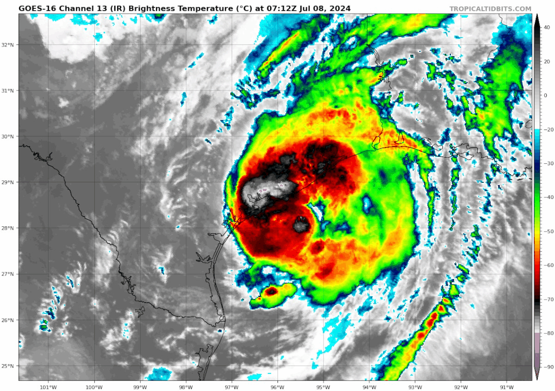
Re: ATL: BERYL - Hurricane - Discussion
In the eye now. It came in decently strong. Certainly felt like a hurricane and not a tropical storm. That eyewall lasted a lot longer than I expected. It did not want to come onto land. Loads of mesovortices on the inner side, very dirty.
I'll say the line, "If this had another 12 hours, this would've been a very nasty Hurricane." It is the truth though.
I'll say the line, "If this had another 12 hours, this would've been a very nasty Hurricane." It is the truth though.
10 likes
-
Texas Snowman
- Storm2k Moderator
- Posts: 6197
- Joined: Fri Jan 25, 2008 11:29 am
- Location: Denison, Texas
Re: ATL: BERYL - Hurricane - Discussion
3 likes
The above post and any post by Texas Snowman is NOT an official forecast and should not be used as such. It is just the opinion of the poster and may or may not be backed by sound meteorological data. It is NOT endorsed by any professional institution including storm2k.org. For official information, please refer to NWS products.
-
AtlanticWind

- S2K Supporter

- Posts: 1898
- Age: 67
- Joined: Sun Aug 08, 2004 9:57 pm
- Location: Plantation,Fla
Re: ATL: BERYL - Hurricane - Discussion
capNstorms wrote:getting really close to cat 2 status right now, this thing is really ramping up with convective activity
This is 80 mph storm , don’t see it reaching cat 2 in the next few minutes before landfall
3 likes
-
Texas Snowman
- Storm2k Moderator
- Posts: 6197
- Joined: Fri Jan 25, 2008 11:29 am
- Location: Denison, Texas
Re: ATL: BERYL - Hurricane - Discussion
1 likes
The above post and any post by Texas Snowman is NOT an official forecast and should not be used as such. It is just the opinion of the poster and may or may not be backed by sound meteorological data. It is NOT endorsed by any professional institution including storm2k.org. For official information, please refer to NWS products.
-
Texas Snowman
- Storm2k Moderator
- Posts: 6197
- Joined: Fri Jan 25, 2008 11:29 am
- Location: Denison, Texas
Re: ATL: BERYL - Hurricane - Discussion
Josh Morgerman with a video of the calm “deep in the eye” of Hurricane Beryl at 3:15 a.m. in Matagorda…
2 likes
The above post and any post by Texas Snowman is NOT an official forecast and should not be used as such. It is just the opinion of the poster and may or may not be backed by sound meteorological data. It is NOT endorsed by any professional institution including storm2k.org. For official information, please refer to NWS products.
Re: ATL: BERYL - Hurricane - Discussion
Been looking at weather stations in the area bearing in mind we don't know the accuracy nor the positioning of the weather stations. Looks like most of the high wind reading was on the southern side.
Wind 82.1 mph, Gust 98.2 mph https://www.wunderground.com/dashboard/pws/KTXMATAG14
Wind 69.2 mph, Gust 71 mph https://www.wunderground.com/dashboard/pws/KTXBAYCI43
Wind 69.4 mph, Gust 71 mph https://www.wunderground.com/dashboard/pws/KTXBAYCI43
Wind 64.9 Mph, Gust 71.6 mph https://www.wunderground.com/dashboard/pws/KTXPORTL288
Wind 57.9 mph Gust 63.5 mph https://www.wunderground.com/dashboard/pws/KTXMATAG35
1 likes
-
AtlanticWind
- S2K Supporter
- Posts: 1898
- Age: 67
- Joined: Sun Aug 08, 2004 9:57 pm
- Location: Plantation,Fla
-
Texas Snowman
- Storm2k Moderator
- Posts: 6197
- Joined: Fri Jan 25, 2008 11:29 am
- Location: Denison, Texas
Re: ATL: BERYL - Hurricane - Discussion
0 likes
The above post and any post by Texas Snowman is NOT an official forecast and should not be used as such. It is just the opinion of the poster and may or may not be backed by sound meteorological data. It is NOT endorsed by any professional institution including storm2k.org. For official information, please refer to NWS products.
-
Texas Snowman
- Storm2k Moderator
- Posts: 6197
- Joined: Fri Jan 25, 2008 11:29 am
- Location: Denison, Texas
Re: ATL: BERYL - Hurricane - Discussion
BULLETIN
Hurricane Beryl Advisory Number 39
NWS National Hurricane Center Miami FL AL022024
400 AM CDT Mon Jul 08 2024
...CENTER OF BERYL MAKES LANDFALL NEAR MATAGORDA TEXAS...
...DANGEROUS STORM SURGE AND STRONG WINDS OCCURRING WITH FLASH
FLOODING EXPECTED...
SUMMARY OF 400 AM CDT...0900 UTC...INFORMATION
----------------------------------------------
LOCATION...28.6N 96.0W
ABOUT 0 MI...0 KM N OF MATAGORDA TEXAS
ABOUT 85 MI...135 KM SSW OF HOUSTON TEXAS
MAXIMUM SUSTAINED WINDS...80 MPH...130 KM/H
PRESENT MOVEMENT...N OR 355 DEGREES AT 12 MPH...19 KM/H
MINIMUM CENTRAL PRESSURE...979 MB...28.91 INCHES
WATCHES AND WARNINGS
--------------------
CHANGES WITH THIS ADVISORY:
The Tropical Storm Warning has been discontinued south of Mesquite
Bay Texas.
SUMMARY OF WATCHES AND WARNINGS IN EFFECT:
A Storm Surge Warning is in effect for...
* Mesquite Bay to Sabine Pass, including Matagorda Bay and Galveston
Bay
A Hurricane Warning is in effect for...
* The Texas coast from Mesquite Bay northward to Port Bolivar
A Tropical Storm Warning is in effect for...
* The Texas coast north of Port Bolivar to Sabine Pass
A Hurricane Warning means that hurricane conditions are expected
somewhere within the warning area.
A Tropical Storm Warning means that tropical storm conditions are
expected within the warning area.
A Storm Surge Warning means there is a danger of life-threatening
inundation, from rising water moving inland from the coastline,
during the next 36 hours in the indicated locations. For a
depiction of areas at risk, please see the National Weather
Service Storm Surge Watch/Warning Graphic, available at
hurricanes.gov. This is a life-threatening situation. Persons
located within these areas should take all necessary actions to
protect life and property from rising water and the potential for
other dangerous conditions. Promptly follow evacuation and other
instructions from local officials.
For storm information specific to your area, including possible
inland watches and warnings, please monitor products issued by your
local National Weather Service forecast office.
DISCUSSION AND OUTLOOK
----------------------
At 400 AM CDT (0900 UTC), the center of Hurricane Beryl was located
near latitude 28.6 North, longitude 96.0 West. Beryl is moving
toward the north near 12 mph (19 km/h). A turn toward the northeast
with an increase in forward speed is expected tonight and Tuesday.
On the forecast track, the center of Beryl will move over eastern
Texas today, then move through the Lower Mississippi Valley into
the Ohio Valley on Tuesday and Wednesday.
Reports from an Air Force Reserve Hurricane Hunter aircraft and
National Weather Service Doppler radar data indicate that maximum
sustained winds are near 80 mph (130 km/h) with higher gusts.
Steady to rapid weakening is expected as the center moves inland,
and Beryl is expected to weaken to a tropical storm later today and
to a tropical depression on Tuesday.
Hurricane-force winds extend outward up to 45 miles (75 km) from the
center and tropical-storm-force winds extend outward up to 115 miles
(185 km). A National Ocean Service Station near Freeport, Texas,
recently reported a sustained wind of 71 mph (114 km/h) and a wind
gust of 87 mph (140 km/h). A WeatherFlow station at Surfside
Beach, Texas, recently reported a wind gust of 85 mph (137 km/h).
The latest minimum central pressure reported by the Hurricane
Hunter aircraft is 979 mb (28.91 inches). Weatherflow and National
Ocean Service stations near Matagorda recently reported pressures
near 981 mb (28.97 inches) inside the eye of Beryl.
3 likes
The above post and any post by Texas Snowman is NOT an official forecast and should not be used as such. It is just the opinion of the poster and may or may not be backed by sound meteorological data. It is NOT endorsed by any professional institution including storm2k.org. For official information, please refer to NWS products.

Re: ATL: BERYL - Hurricane - Discussion
Mesoscale Discussion 1555
NWS Storm Prediction Center Norman OK
0228 AM CDT Mon Jul 08 2024
https://www.spc.noaa.gov/products/md/md1555.html
Areas affected...The Texas Coast near Galveston Island
Concerning...Tornado Watch 513...
Valid 080728Z - 080915Z
CORRECTED FOR ADDITION OF HURRICANE BERYL ATTRIBUTION
The severe weather threat for Tornado Watch 513 continues.
SUMMARY...The greatest tornado threat with Hurricane Beryl will
exist in the vicinity of Galveston Island over the next few hours.
DISCUSSION...Two outer rain bands with embedded mini-supercells are
rotating inland near Galveston Island early this evening. One of
these storms produced an apparent tornado debris signature as it
crossed the southern part of the island. As these rotating storms
continue to pivot inland this morning, expect a continued tornado
threat. However, this threat is expected to remain mostly confined
to areas near the coast where the best wind profile and instability
exists. Expect the greatest tornado threat to shift north through
the early morning hours as outer bands shift north due to Hurricane
Beryl's continued northward movement.
..Bentley.. 07/08/2024
1 likes
-
GalvestonDuck
- Category 5

- Posts: 15941
- Age: 57
- Joined: Fri Oct 11, 2002 8:11 am
- Location: Galveston, oh Galveston (And yeah, it's a barrier island. Wanna make something of it?)
Re: ATL: BERYL - Hurricane - Discussion
Getting gusts up to 71mph, sustained at 38 here on the east end of Galveston Island. Flickers of power outages as well.
3 likes

Re: ATL: BERYL - Hurricane - Discussion
Really starting to come down in Houston. Wind picking up
3 likes
-
NXStumpy_Robothing
- Category 1

- Posts: 335
- Age: 25
- Joined: Fri Jun 05, 2020 11:50 pm
- Location: North Georgia
Re: ATL: BERYL - Hurricane - Discussion
Yet another intensifying Gulf storm that "ran out of time" - one that we wonder what would've happened if it had "12/24/whatever # of hours more over water". Getting real tired of storms doing that and of hearing it.
Took awhile to finally mix out the last of the pesky dry air that had been pumped into the system by the decaying upper-level low over the past few days, but once it did it wrapped up quickly (with some help from frictional convergence along the Texas coastline). Very impressive radar & satellite imagery, and radar velocities as Beryl organized right before landfall, as expected. I think there's some serious argument that the NHC could've gone as high as 80kt on the official landfall intensity from both recon data and the aforementioned velocity bins, but that's a relatively minor gripe. NHC never really wavered from their predicted intensity at landfall, and, while there were some relatively late adjustments to the track forecast, it all seemed to verify quite well with Beryl struggling until the last 12 hours or so before coming ashore near Matagorda. Some work to be done as always but kudos are merited and are given.
Definitely an impressive system, even with its post-Yucatan struggles compared to the more aggressive modeling solutions, and very much a foreboding sign on what may come later in the year. Hopefully it now just goes poof, though unfortunately it's likely to produce tons of power outages and downed trees from a combination of heavy rain and wind in the Houston area. Ridiculous to track, and ridiculous to see it still going and trying to give Texas one last scare tonight.
5 likes
Undergraduate Meteorology Student, Georgia Institute of Technology

Re: ATL: BERYL - Hurricane - Discussion
Definitely looks like a storm that would have caused major troubles if it had 24 more hours over water.
10 likes
TC naming lists: retirements and intensity
Most aggressive Advisory #1's in North Atlantic (cr. kevin for starting the list)
Most aggressive Advisory #1's in North Atlantic (cr. kevin for starting the list)
Who is online
Users browsing this forum: No registered users and 15 guests