ATL: MILTON - Post-Tropical - Discussion

Moderator: S2k Moderators

Message
Author
User avatar
chris_fit
Category 5
Category 5
Posts: 3222
Age: 42
Joined: Wed Sep 10, 2003 11:58 pm
Location: Tampa Bay Area, FL

Re: ATL: MILTON - Hurricane - Discussion

#4161 Postby chris_fit » Wed Oct 09, 2024 5:42 am

eastcoastFL wrote:Based on the shear map he’s been under 40kts of shear for a while and it’s not making much of a difference so far.


You don't see a difference? Compare IR image from 1.5 hrs ago to now. Winds/Pressure will respond shortly.
0 likes   

Keldeo1997
Category 2
Category 2
Posts: 637
Joined: Fri Oct 11, 2019 11:35 pm

Re: ATL: MILTON - Hurricane - Discussion

#4162 Postby Keldeo1997 » Wed Oct 09, 2024 5:42 am

Image

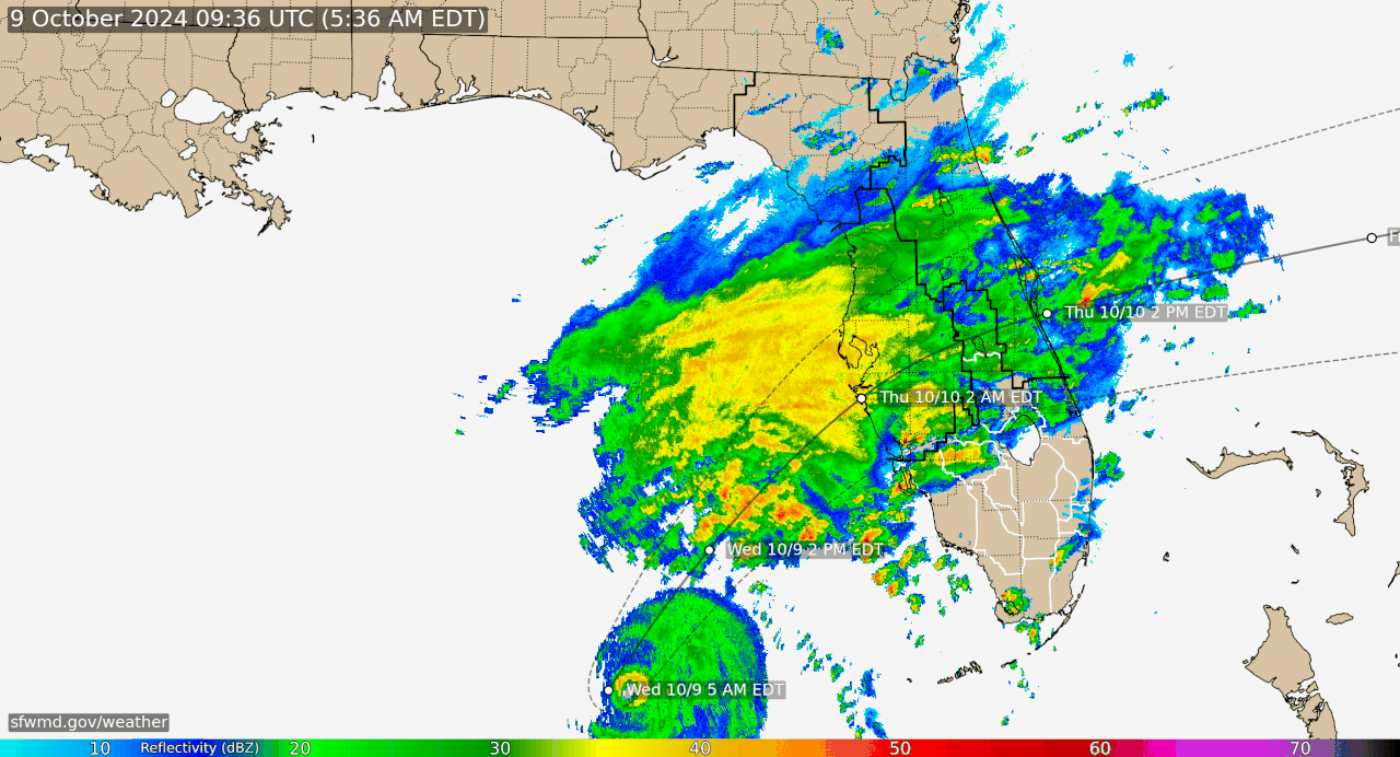
This was dropped well to the west before NOAA went in. No dry air yet
0 likes   

User avatar
kevin
Category 5
Category 5
Posts: 2587
Age: 26
Joined: Wed Aug 28, 2019 4:35 am

Re: ATL: MILTON - Hurricane - Discussion

#4163 Postby kevin » Wed Oct 09, 2024 5:42 am

chris_fit wrote:I think at this point, this is one of the least atheistically pleasing cat 5 I've ever seen.

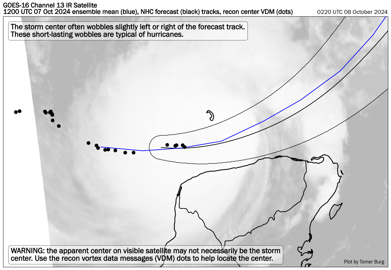
https://i.imgur.com/TFUb70v.png


I'm all for deterioration of Milton from now on. 12 hours ago it was one of the most perfect looking cat 5's I've seen.
2 likes   

User avatar
GCANE
S2K Supporter
S2K Supporter
Posts: 11500
Joined: Mon Oct 22, 2007 8:03 am

Re: ATL: MILTON - Hurricane - Discussion

#4164 Postby GCANE » Wed Oct 09, 2024 5:43 am

alan1961 wrote:
GCANE wrote:Area of ionospheric heating is starting to come over Milton and there is a massive hot tower now firing on the west eyewall.

https://solarham.com/globald.htm

https://weather.cod.edu/satrad/?parms=s ... =undefined


Gcane you mentioned the possibility of a quake around the yucatan due to the ionospherics..is this the one i wonder?

https://imgur.com/L1H9Gb3


I don't see it on the USGS map.
Was that yesterday or today?
0 likes   

User avatar
eastcoastFL
Category 5
Category 5
Posts: 3901
Age: 43
Joined: Thu Apr 12, 2007 12:29 pm
Location: Palm City, FL

Re: ATL: MILTON - Hurricane - Discussion

#4165 Postby eastcoastFL » Wed Oct 09, 2024 5:46 am

chris_fit wrote:
eastcoastFL wrote:Based on the shear map he’s been under 40kts of shear for a while and it’s not making much of a difference so far.


You don't see a difference? Compare IR image from 1.5 hrs ago to now. Winds/Pressure will respond shortly.


Recon just recorded 913mb I was hoping to see something much higher by now, I am watching it on radar and it looks solid still for now maybe a little trouble on the western side. But he cruised through fairly high shear all night without issue.
0 likes   
Personal Forecast Disclaimer:
The posts in this forum are NOT official forecast and should not be used as such. They are just the opinion of the poster and may or may not be backed by sound meteorological data. They are NOT endorsed by any professional institution or storm2k.org. For official information, please refer to the NHC and NWS products.

User avatar
GCANE
S2K Supporter
S2K Supporter
Posts: 11500
Joined: Mon Oct 22, 2007 8:03 am

Re: ATL: MILTON - Hurricane - Discussion

#4166 Postby GCANE » Wed Oct 09, 2024 5:48 am

Interesting

AF300's latest VDM didn't mention a double eyewall.

Let's see what Miss Piggy has to say
1 likes   

User avatar
GCANE
S2K Supporter
S2K Supporter
Posts: 11500
Joined: Mon Oct 22, 2007 8:03 am

Re: ATL: MILTON - Hurricane - Discussion

#4167 Postby GCANE » Wed Oct 09, 2024 5:50 am

Eye is definitely deteriorating.
0 likes   

User avatar
chris_fit
Category 5
Category 5
Posts: 3222
Age: 42
Joined: Wed Sep 10, 2003 11:58 pm
Location: Tampa Bay Area, FL

Re: ATL: MILTON - Hurricane - Discussion

#4168 Postby chris_fit » Wed Oct 09, 2024 5:51 am

Pinhole Eye seems to FINALLY be weakening. Notable drop in reds and oranges.

https://www.sfwmd.gov/weather-radar/cur ... conditions
0 likes   

User avatar
eastcoastFL
Category 5
Category 5
Posts: 3901
Age: 43
Joined: Thu Apr 12, 2007 12:29 pm
Location: Palm City, FL

Re: ATL: MILTON - Hurricane - Discussion

#4169 Postby eastcoastFL » Wed Oct 09, 2024 5:51 am

GCANE wrote:Interesting

AF300's latest VDM didn't mention a double eyewall.

Let's see what Miss Piggy has to say


G, how’s our tornado outlook for the southern half of Florida?
1 likes   
Personal Forecast Disclaimer:
The posts in this forum are NOT official forecast and should not be used as such. They are just the opinion of the poster and may or may not be backed by sound meteorological data. They are NOT endorsed by any professional institution or storm2k.org. For official information, please refer to the NHC and NWS products.

User avatar
Nimbus
Category 5
Category 5
Posts: 5306
Joined: Mon Jul 19, 2004 10:54 am

Re: ATL: MILTON - Hurricane - Discussion

#4170 Postby Nimbus » Wed Oct 09, 2024 5:52 am

pmang6 wrote:Last VDM has 913mb, Dvorak weakening flag is on, and the eye has begun to cool/cloud over on IR. C'mon dry air, hop in, the water's nice!


I just woke up to the 913 mb recon fix and some of the models insisting Milton will maintain strength into Tampa bay.
Real time looks like shear has started eroding the NW quadrant and dry air may have a chance to reach the core this morning which would be earlier than forecast.

We have the radar with the official forecast track and we know the GFS is predicting some strange track behavior before landfall.
My guess would be another EWRC followed by a reformation further east with the usual shear fallout.

NHC is watching this and will have a better explanation at 11AM.
1 likes   

pmang6
Tropical Low
Tropical Low
Posts: 18
Joined: Sat Aug 28, 2021 7:03 pm

Re: ATL: MILTON - Hurricane - Discussion

#4171 Postby pmang6 » Wed Oct 09, 2024 5:54 am

eastcoastFL wrote:
pmang6 wrote:Dvorak rapid dissipation flag now on, for whatever that's worth.


What does that mean?


Here's the ADT user guide: https://tropic.ssec.wisc.edu/misc/adt/g ... _Guide.pdf

Pages 42-44 have what you're looking for. Apparently its more of an EPAC thing, but there is mention of it being periodically relevant in other basins.
1 likes   

User avatar
eastcoastFL
Category 5
Category 5
Posts: 3901
Age: 43
Joined: Thu Apr 12, 2007 12:29 pm
Location: Palm City, FL

Re: ATL: MILTON - Hurricane - Discussion

#4172 Postby eastcoastFL » Wed Oct 09, 2024 5:54 am

It does look like the windfield is expanding. Recon is finding hurricane force winds further east than I’ve seen in previous passes.
0 likes   
Personal Forecast Disclaimer:
The posts in this forum are NOT official forecast and should not be used as such. They are just the opinion of the poster and may or may not be backed by sound meteorological data. They are NOT endorsed by any professional institution or storm2k.org. For official information, please refer to the NHC and NWS products.

User avatar
eastcoastFL
Category 5
Category 5
Posts: 3901
Age: 43
Joined: Thu Apr 12, 2007 12:29 pm
Location: Palm City, FL

Re: ATL: MILTON - Hurricane - Discussion

#4173 Postby eastcoastFL » Wed Oct 09, 2024 5:55 am

pmang6 wrote:
eastcoastFL wrote:
pmang6 wrote:Dvorak rapid dissipation flag now on, for whatever that's worth.


What does that mean?


Here's the ADT user guide: https://tropic.ssec.wisc.edu/misc/adt/g ... _Guide.pdf

Pages 42-44 have what you're looking for. Apparently its more of an EPAC thing, but there is mention of it being periodically relevant in other basins.


Thank you!
0 likes   
Personal Forecast Disclaimer:
The posts in this forum are NOT official forecast and should not be used as such. They are just the opinion of the poster and may or may not be backed by sound meteorological data. They are NOT endorsed by any professional institution or storm2k.org. For official information, please refer to the NHC and NWS products.

User avatar
eastcoastFL
Category 5
Category 5
Posts: 3901
Age: 43
Joined: Thu Apr 12, 2007 12:29 pm
Location: Palm City, FL

Re: ATL: MILTON - Hurricane - Discussion

#4174 Postby eastcoastFL » Wed Oct 09, 2024 5:56 am

65mm/hr rain rate in NE quad
0 likes   
Personal Forecast Disclaimer:
The posts in this forum are NOT official forecast and should not be used as such. They are just the opinion of the poster and may or may not be backed by sound meteorological data. They are NOT endorsed by any professional institution or storm2k.org. For official information, please refer to the NHC and NWS products.

User avatar
GCANE
S2K Supporter
S2K Supporter
Posts: 11500
Joined: Mon Oct 22, 2007 8:03 am

Re: ATL: MILTON - Hurricane - Discussion

#4175 Postby GCANE » Wed Oct 09, 2024 5:58 am

eastcoastFL wrote:
GCANE wrote:Interesting

AF300's latest VDM didn't mention a double eyewall.

Let's see what Miss Piggy has to say


G, how’s our tornado outlook for the southern half of Florida?


Southern half not bad. Maybe a sporadic EF1.
Mid FL will be the worse and along the coast when feeder bands rotate in.
1 likes   

xironman
S2K Supporter
S2K Supporter
Posts: 2522
Joined: Sun Jun 10, 2007 4:53 pm
Location: NoVA

Re: ATL: MILTON - Hurricane - Discussion

#4176 Postby xironman » Wed Oct 09, 2024 5:59 am

chris_fit wrote:
eastcoastFL wrote:Based on the shear map he’s been under 40kts of shear for a while and it’s not making much of a difference so far.


You don't see a difference? Compare IR image from 1.5 hrs ago to now. Winds/Pressure will respond shortly.


Probably more the EWRC than shear right now.
0 likes   

User avatar
Blown Away
S2K Supporter
S2K Supporter
Posts: 10152
Joined: Wed May 26, 2004 6:17 am

Re: ATL: MILTON - Hurricane - Discussion

#4177 Postby Blown Away » Wed Oct 09, 2024 6:00 am

Image
Milton was E of the 10pm track, NHC resets at 5am and E again... 8-)
2 likes   
Hurricane Eye Experience: David 79, Irene 99, Frances 04, Jeanne 04, Wilma 05... EYE COMING MY WAY IN 2024…
Hurricane Brush Experience: Andrew 92, Erin 95, Floyd 99, Matthew 16, Irma 17, Ian 22, Nicole 22…

User avatar
GCANE
S2K Supporter
S2K Supporter
Posts: 11500
Joined: Mon Oct 22, 2007 8:03 am

Re: ATL: MILTON - Hurricane - Discussion

#4178 Postby GCANE » Wed Oct 09, 2024 6:01 am

4500 CAPE being ingested into the core now.
0 likes   

xironman
S2K Supporter
S2K Supporter
Posts: 2522
Joined: Sun Jun 10, 2007 4:53 pm
Location: NoVA

Re: ATL: MILTON - Hurricane - Discussion

#4179 Postby xironman » Wed Oct 09, 2024 6:01 am

Roughly ten miles east of the path

Image
1 likes   

User avatar
ColdMiser123
Professional-Met
Professional-Met
Posts: 904
Age: 29
Joined: Mon Sep 26, 2016 3:26 pm
Location: Northeast US

Re: ATL: MILTON - Hurricane - Discussion

#4180 Postby ColdMiser123 » Wed Oct 09, 2024 6:03 am

Based on the latest NOAA pass, Milton is still a 140 kt Cat 5, with 913 mb central pressure.

One of the most significant changes from yesterday are how much the hurricane force flight level winds have expanded on the east side of the storm, thanks to the shear.
1 likes   
B.S., M.S., Meteorology & Atmospheric Science


Return to “2024”

Who is online

Users browsing this forum: No registered users and 8 guests