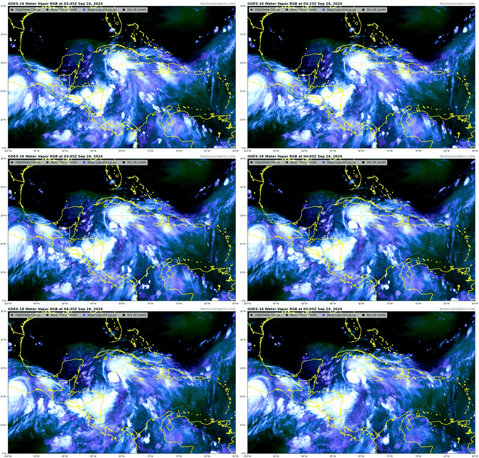
ATL: HELENE - Post-Tropical - Discussion

Moderator: S2k Moderators

Message
Author
redingtonbeach
Tropical Depression
Tropical Depression
Posts: 56
Joined: Mon Sep 04, 2017 12:05 am

Re: ATL: NINE - Potential Tropical Cyclone - Discussion

#661 Postby redingtonbeach » Mon Sep 23, 2024 11:12 pm

wx98 wrote:
redingtonbeach wrote:I’ve been calling for a Crystal River landfall ever since the HMON model swung far east, the first one to do so while the others were saying New Orleans or so. Just a gut feeling as I’m no MET but the 200mb and 500mb winds that day, coupled with the progression of other CONUS depictions, made sense at the time. I did not notice the stacking issue in the model, however. It just seemed to be right loaded as it entered the GOM.

No models were saying New Orleans when the HMON first ran yesterday…


My bad. It was the GEM on the 12th that was south of Tampa.
2 likes   

CrazyC83
Professional-Met
Professional-Met
Posts: 34002
Joined: Tue Mar 07, 2006 11:57 pm
Location: Deep South, for the first time!

Re: ATL: NINE - Potential Tropical Cyclone - Discussion

#662 Postby CrazyC83 » Mon Sep 23, 2024 11:15 pm

Blown Away wrote:[url]https://i.postimg.cc/mkp3q4Kc/goes16-ir-09-L-202409240135.gif [/url]

Nice little pulse of deep convection just E of the 11pm position of 18.4N/82.4W… PTC9 Been hanging around this position most of the day…


Perhaps the MLC will redevelop there and that will become the dominant center instead?
1 likes   

User avatar
stormhunter7
Category 2
Category 2
Posts: 762
Joined: Mon May 26, 2008 3:13 pm
Location: Panama City Beach, Florida
Contact:

Re: ATL: NINE - Potential Tropical Cyclone - Discussion

#663 Postby stormhunter7 » Mon Sep 23, 2024 11:20 pm

CrazyC83 wrote:
Blown Away wrote:[url]https://i.postimg.cc/mkp3q4Kc/goes16-ir-09-L-202409240135.gif [/url]

Nice little pulse of deep convection just E of the 11pm position of 18.4N/82.4W… PTC9 Been hanging around this position most of the day…


Perhaps the MLC will redevelop there and that will become the dominant center instead?


Good thing Recon is enroute across the GOM to find out what's under that hood!
1 likes   
The following post is NOT an official forecast and should not be used as such. It is just the opinion of the poster and may or may not be backed by sound meteorological data. It is NOT endorsed by any professional institution including storm2k.org For Official Information please refer to the NHC and NWS products. http://www.nhc.noaa.gov

caneman
Category 5
Category 5
Posts: 1447
Joined: Fri Sep 05, 2014 5:44 am
Location: Clearwater Beach, Fl

Re: ATL: NINE - Potential Tropical Cyclone - Discussion

#664 Postby caneman » Mon Sep 23, 2024 11:20 pm

Massive hot tower there. We will see if it holds through the night.
0 likes   

User avatar
StPeteMike
Category 2
Category 2
Posts: 631
Joined: Thu Jun 07, 2018 11:26 pm

Re: ATL: NINE - Potential Tropical Cyclone - Discussion

#665 Postby StPeteMike » Mon Sep 23, 2024 11:21 pm

Thoughts before bed…

Even though I would love for this to be a bust storm and nothing develops, that is not the reality. Hopefully we get TS status by 8 am and watches and evacuation orders can start rolling out. Even with a Big Bend landfall, NHC has 9 feet projected in the Tampa Bay region. That’s a lot of people to evacuate with about 2 days, considering that encompass both Zone A and B in the coastal and riverfront areas.

Love that the models have a weaker hurricane, but I have been here before. The water temps that future Helene will go over don’t lie, she will have gasoline to ramp up. I still expect a major hurricane impact somewhere in Florida.

Tomorrow is going to be a crazy day for this area, as well as much of the Big Bend region. I’m hoping the models can show consistency on the landfall throughout tomorrow so we have an understanding on what residents should do. Crazy that at 48 hours from when I’ll wake up for work, we will be starting to feel the affects of future Helene and we have nothing yet. I think anyone that lives on FL West Coast has all means to feel anxious. But if you check with 90% of the people in the region, they either don’t know there’s a storm or have written it off already.

Night y’all!
7 likes   
The above post is not official and should not be used as such. It is the opinion of the poster and may or may not be backed by sound meteorological data. It is not endorsed by any professional institution or storm2k.org. For official information, please refer to the NHC and NWS products.

stltkd
Tropical Wave
Tropical Wave
Posts: 3
Joined: Sun Aug 29, 2021 11:24 am

Re: ATL: NINE - Potential Tropical Cyclone - Discussion

#666 Postby stltkd » Mon Sep 23, 2024 11:39 pm

StPeteMike wrote:Thoughts before bed

Tomorrow is going to be a crazy day for this area, as well as much of the Big Bend region. I’m hoping the models can show consistency on the landfall throughout tomorrow so we have an understanding on what residents should do. Crazy that at 48 hours from when I’ll wake up for work, we will be starting to feel the affects of future Helene and we have nothing yet. I think anyone that lives on FL West Coast has all means to feel anxious. But if you check with 90% of the people in the region, they either don’t know there’s a storm or have written it off already.

Night y’all!


I work part-time at a Walgreens in Lee County, FL. I have already seen a major uptick in essentials sales - water, propane, and alcohol were major hot sellers tonight. Much more so than when this far out than when Ian hit. While, most are still not super anxious, people seem to be taking this one more seriously.
3 likes   

TomballEd
Category 2
Category 2
Posts: 700
Age: 61
Joined: Wed Aug 16, 2023 4:52 pm
Location: Spring/Klein area, not Tomball

Re: ATL: NINE - Potential Tropical Cyclone - Discussion

#667 Postby TomballEd » Mon Sep 23, 2024 11:53 pm

They still have the blue color SWIR at the CIMSS site, not as easy to see low level vs high level flow as when SSD used the blue colored SWIR, but I think convection is trying to build over the LLC and that the LLC being better coupled to the MLC is imminent. If I was NHC, I would have requested one more low level mission today.
0 likes   

CrazyC83
Professional-Met
Professional-Met
Posts: 34002
Joined: Tue Mar 07, 2006 11:57 pm
Location: Deep South, for the first time!

Re: ATL: NINE - Potential Tropical Cyclone - Discussion

#668 Postby CrazyC83 » Tue Sep 24, 2024 12:02 am

From what I can tell, the LLC is at 18.1N 82.2W. That would be on the western edge of that large ball of convection, as opposed to far removed.

Maybe the old MLC is dissipating as well? Hard to say.
0 likes   

Poonwalker
Category 1
Category 1
Posts: 270
Joined: Tue Sep 20, 2022 11:12 am

Re: ATL: NINE - Potential Tropical Cyclone - Discussion

#669 Postby Poonwalker » Tue Sep 24, 2024 12:19 am

CrazyC83 wrote:From what I can tell, the LLC is at 18.1N 82.2W. That would be on the western edge of that large ball of convection, as opposed to far removed.

Maybe the old MLC is dissipating as well? Hard to say.


the Hafs models are picking that up as the LLC. Euro as well.
0 likes   

LandoWill
Tropical Storm
Tropical Storm
Posts: 154
Joined: Sun Sep 25, 2022 10:25 pm

Re: ATL: NINE - Potential Tropical Cyclone - Discussion

#670 Postby LandoWill » Tue Sep 24, 2024 12:20 am

StPeteMike wrote:Thoughts before bed…

Even though I would love for this to be a bust storm and nothing develops, that is not the reality. Hopefully we get TS status by 8 am and watches and evacuation orders can start rolling out. Even with a Big Bend landfall, NHC has 9 feet projected in the Tampa Bay region. That’s a lot of people to evacuate with about 2 days, considering that encompass both Zone A and B in the coastal and riverfront areas.

Love that the models have a weaker hurricane, but I have been here before. The water temps that future Helene will go over don’t lie, she will have gasoline to ramp up. I still expect a major hurricane impact somewhere in Florida.

Tomorrow is going to be a crazy day for this area, as well as much of the Big Bend region. I’m hoping the models can show consistency on the landfall throughout tomorrow so we have an understanding on what residents should do. Crazy that at 48 hours from when I’ll wake up for work, we will be starting to feel the affects of future Helene and we have nothing yet. I think anyone that lives on FL West Coast has all means to feel anxious. But if you check with 90% of the people in the region, they either don’t know there’s a storm or have written it off already.

Night y’all!

That's typical for this area, we've been gaslit for 40 years, that the big one would come, and it never does. You never know of course. Just look at Elena, it did loops and was coming for us when i was like 8-9 years old lol ,. i still remember the days in the shelter.
0 likes   

TomballEd
Category 2
Category 2
Posts: 700
Age: 61
Joined: Wed Aug 16, 2023 4:52 pm
Location: Spring/Klein area, not Tomball

Re: ATL: NINE - Potential Tropical Cyclone - Discussion

#671 Postby TomballEd » Tue Sep 24, 2024 12:23 am

Over the on the models thread- after a muted 18Z following a nuclear 12Z series of runs, the high res hurricane models are swinging back to significant hurricane mode.

Upper low near the Yucatan that has been shearing PTC9 is backing W, shear should be dropping as modeled.

Image
0 likes   

TomballEd
Category 2
Category 2
Posts: 700
Age: 61
Joined: Wed Aug 16, 2023 4:52 pm
Location: Spring/Klein area, not Tomball

Re: ATL: NINE - Potential Tropical Cyclone - Discussion

#672 Postby TomballEd » Tue Sep 24, 2024 12:26 am

Nobody has been gaslit on Tampa hurricanes. 50 years ago I heard of the protective dome left by the Native Americans. Big hurricanes are infrequent, and the models are not programmed to deceive. Tampa may go one hundred years before 'The Big One'. Or it could happen as soon as Wednesday night.
1 likes   

Chris_in_Tampa
Category 5
Category 5
Posts: 5075
Age: 41
Joined: Thu Jun 21, 2007 11:06 pm
Location: Tampa, Florida, USA
Contact:

Re: ATL: NINE - Potential Tropical Cyclone - Discussion

#673 Postby Chris_in_Tampa » Tue Sep 24, 2024 12:43 am

StPeteMike wrote:Even with a Big Bend landfall, NHC has 9 feet projected in the Tampa Bay region.


On this product that 9 feet in places means:

"*Displayed flooding values indicate the water height that has about a 1-in-10 (10%) chance of being exceeded."

That's not an NHC forecast.

"This map is based on PSURGE 2.0 guidance. Probabilistic and exceedance output can be viewed here: http://slosh.nws.noaa.gov/psurge2.0/.

The NHC isn't yet forecasting surge for places other than southwest Florida in the public advisory:

https://www.nhc.noaa.gov/text/refresh/MIATCPAT4+shtml/#:~:text=STORM%20SURGE:

It's too early yet for areas further northward.
2 likes   

User avatar
ConvergenceZone
Category 5
Category 5
Posts: 5194
Joined: Fri Jul 29, 2005 1:40 am
Location: Northern California

Re: ATL: NINE - Potential Tropical Cyclone - Discussion

#674 Postby ConvergenceZone » Tue Sep 24, 2024 12:47 am

TomballEd wrote:Over the on the models thread- after a muted 18Z following a nuclear 12Z series of runs, the high res hurricane models are swinging back to significant hurricane mode.

Upper low near the Yucatan that has been shearing PTC9 is backing W, shear should be dropping as modeled.

https://i.giphy.com/media/v1.Y2lkPTc5MGI3NjExNGM1MnVwcXYzMG9zeDF5c2NiZ3ZseHNxZWozY2RiazNoZHhzN2thNCZlcD12MV9pbnRlcm5hbF9naWZfYnlfaWQmY3Q9Zw/UPNCSoz2xGkhDaLBmv/giphy.gif


I think it's only the over excited H Models(can never remember the letters) that are showing anything real significant. All the others are the same or weaker, but please correct me if I'm wrong.
0 likes   

User avatar
Woofde
Category 1
Category 1
Posts: 480
Joined: Tue Jul 06, 2021 11:33 am

Re: ATL: NINE - Potential Tropical Cyclone - Discussion

#675 Postby Woofde » Tue Sep 24, 2024 12:49 am

Going to be some light sleep night's for sure with this one. I have a strange feeling that this going to be another Perrycane much to my chaser anoyance. I pray not, those poor people in Perry man... Idalia was horrible for them, then Debby didn't help. I cannot imagine them having fully repaired since I was last there. This could end up as a permanent exodus event for that area if it does smack there. Seriously getting hit by back to back major hurricanes would take incredibly horrible luck. The return rate for this area is supposed to be 36 years.Image
3 likes   

User avatar
kevin
Category 5
Category 5
Posts: 2586
Age: 26
Joined: Wed Aug 28, 2019 4:35 am

Re: ATL: NINE - Potential Tropical Cyclone - Discussion

#676 Postby kevin » Tue Sep 24, 2024 1:47 am

Recon is entering the storm now. Still far away from the center and winds already support an intensity of 35 kt. General pressure in the region also seems to have dropped as it's now 1005 mbar still about 250 km (150 miles) from the center.
0 likes   

User avatar
GCANE
S2K Supporter
S2K Supporter
Posts: 11497
Joined: Mon Oct 22, 2007 8:03 am

Re: ATL: NINE - Potential Tropical Cyclone - Discussion

#677 Postby GCANE » Tue Sep 24, 2024 2:24 am

Big-time blow up in convection.
All the convective debris from yesterday afternoon's pop-up thunderstorms over CA are feeding directly into her.
1 likes   

User avatar
tropicwatch
Category 5
Category 5
Posts: 3384
Age: 61
Joined: Sat Jun 02, 2007 10:01 am
Location: Panama City Florida
Contact:

Re: ATL: NINE - Potential Tropical Cyclone - Discussion

#678 Postby tropicwatch » Tue Sep 24, 2024 2:26 am

Hurricane Hunter is flying a different pattern. I like it, would think it would get a sampling of more of the storm with this pattern.
0 likes   
Tropicwatch


Agnes 72', Eloise 75, Elena 85', Kate 85', Charley 86', Florence 88', Beryl 94', Dean 95', Erin 95', Opal 95', Earl 98', Georges 98', Ivan 2004', Arlene 2005', Dennis 2005', Ida 2009' Debby 2012' Irma 2017' Michael 2018'

xironman
S2K Supporter
S2K Supporter
Posts: 2522
Joined: Sun Jun 10, 2007 4:53 pm
Location: NoVA

Re: ATL: NINE - Potential Tropical Cyclone - Discussion

#679 Postby xironman » Tue Sep 24, 2024 2:41 am

tropicwatch wrote:Hurricane Hunter is flying a different pattern. I like it, would think it would get a sampling of more of the storm with this pattern.

They will probably have the NOAA plane do a center drop for the 5am. I take that back the NOAA is synoptic
0 likes   

User avatar
eastcoastFL
Category 5
Category 5
Posts: 3901
Age: 43
Joined: Thu Apr 12, 2007 12:29 pm
Location: Palm City, FL

Re: ATL: NINE - Potential Tropical Cyclone - Discussion

#680 Postby eastcoastFL » Tue Sep 24, 2024 2:57 am

TomballEd wrote:Over the on the models thread- after a muted 18Z following a nuclear 12Z series of runs, the high res hurricane models are swinging back to significant hurricane mode.

Upper low near the Yucatan that has been shearing PTC9 is backing W, shear should be dropping as modeled.

https://i.giphy.com/media/v1.Y2lkPTc5MGI3NjExNGM1MnVwcXYzMG9zeDF5c2NiZ3ZseHNxZWozY2RiazNoZHhzN2thNCZlcD12MV9pbnRlcm5hbF9naWZfYnlfaWQmY3Q9Zw/UPNCSoz2xGkhDaLBmv/giphy.gif


It looks like it's going to be tough for the system to split the channel. It might clip the western edge of Cuba.
1 likes   
Personal Forecast Disclaimer:
The posts in this forum are NOT official forecast and should not be used as such. They are just the opinion of the poster and may or may not be backed by sound meteorological data. They are NOT endorsed by any professional institution or storm2k.org. For official information, please refer to the NHC and NWS products.


Return to “2024”

Who is online

Users browsing this forum: No registered users and 4 guests