ATL: HELENE - Post-Tropical - Discussion
Moderator: S2k Moderators
Re: ATL: NINE - Potential Tropical Cyclone - Discussion
The latest center pass by the NOAA plane found a minimum pressure of 999.7 mbar with a minimum FL wind of 7 kt in its vicinity, which would translate to a current intensity of 999 mbar. Seems like there is slow strengthening over the last hours of about ~0.5 mbar/hour.
0 likes
- Category5Kaiju
- Category 5

- Posts: 4347
- Joined: Thu Dec 24, 2020 12:45 pm
- Location: Seattle during the summer, Phoenix during the winter
Re: ATL: NINE - Potential Tropical Cyclone - Discussion
DunedinDave wrote:Just for fun, I went back and did some research on Hurricane Ian. Around 48-60 hours before it made landfall near Fort Myers, the NHC had it making landfall some 150 miles north around the Pinellas/Pasco border. In fact, most all the models had it going right through Tampa Bay with hardly any going through Fort Myers. It didn't change until it officially made that right turn earlier than expected and it was a harder right turn than they thought.
And I know Charley did the same thing with a less turnaround time but I brought up Ian because modeling and forecasting is supposed to be so much better in the 2020s than 2000s and it's more recent.
So things can still change a lot either direction and I wouldn't be shocked if they do.
For some reason, storms just off the west coast of the Florida Peninsula tend to do this, where they hook east in the end more than expected. I don't know what this future system's story will be in the end, but I personally do think this phenomenon is important to keep in the back of one's head, especially considering it's fall now, when troughing tends to be more amplified and faster.
1 likes
Unless explicitly stated, all information in my posts is based on my own opinions and observations. Tropical storms and hurricanes can be extremely dangerous. Refer to an accredited weather research agency or meteorologist if you need to make serious decisions regarding an approaching storm.
Re: ATL: NINE - Potential Tropical Cyclone - Discussion
ronjon wrote:pcolaman wrote:GCANE wrote:Still in a very sharp shear gradient.
She will probably not strengthen much today.
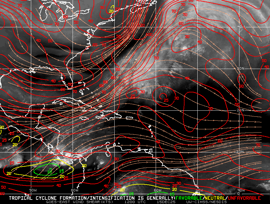
Shear has played a roll for the last few days. Curious to see what happens when she makes it to the Gulf.
Shear is forecast to drop off today as the ULL over the Yuc weakens. If that occurs, we should start seeing increasing organization today.
You can see the cirrus is starting to blow off west of north rather than east. The ULL is south. This vector is much more beneficial for the storm.

1 likes
Re: ATL: NINE - Potential Tropical Cyclone - Discussion
All I have to say regarding the forecasted track is to watch the GFS's trend over the next 24-36 hours, it nailed the track of Francine a good 48 hrs before landfall when all other major models and consensus models were well west. At this point I wouldn't be even taking the EC under consideration because of how bad it did on my books with Francine.
4 likes
Re: ATL: NINE - Potential Tropical Cyclone - Discussion
AF300 measured much higher winds in the NE quadrant (where the convection blow-up was over the last hour). 52 kt FL winds and 41 kt SFMR. NOAA3 also found 49 kt FL winds. Together this is sufficient to raise the current intensity to 45 kt, even though I guess NHC doesn't like to jump too much in one go so they'll go with 999 mbar / 40 kt. I know that I'm a bit less reluctant to pull the trigger on this system than the NHC seems to be, but this seems like an easy bet for TS Helene at 11am.
2 likes
-
Frank P
- S2K Supporter

- Posts: 2779
- Joined: Fri Aug 29, 2003 10:52 am
- Location: Biloxi Beach, Ms
- Contact:
Re: ATL: NINE - Potential Tropical Cyclone - Discussion
Frank P wrote:xironman wrote:ronjon wrote:
Shear is forecast to drop off today as the ULL over the Yuc weakens. If that occurs, we should start seeing increasing organization today.
You can see the cirrus is starting to blow off west of north rather than east. The ULL is south. This vector is much more beneficial for the storm.
https://i.imgur.com/ezEDNct.gif
Looking at that loop and in order for this to hit the west tip of Cuba it going to have to make a hard right turn, unlikely IMO.
0 likes
- cycloneye
- Admin

- Posts: 149727
- Age: 69
- Joined: Thu Oct 10, 2002 10:54 am
- Location: San Juan, Puerto Rico
Re: ATL: NINE - Potential Tropical Cyclone - Discussion
Highest winds found so far from AF plane is Peak Flight-Level Winds: 52kt at 12:48z
0 likes
Visit the Caribbean-Central America Weather Thread where you can find at first post web cams,radars
and observations from Caribbean basin members Click Here
and observations from Caribbean basin members Click Here
-
BIFF_THE_UNRULY
- Tropical Storm

- Posts: 143
- Joined: Fri Jun 28, 2024 2:12 pm
Re: ATL: NINE - Potential Tropical Cyclone - Discussion
i wont sleep better in Tampa or anywhere else is south florida till the storms develops and start moving north and models are still firm set on the nature coast.
Next 24 hours are a big deal here
Next 24 hours are a big deal here
1 likes
Re: ATL: NINE - Potential Tropical Cyclone - Discussion
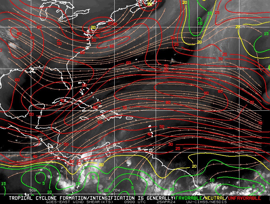
In the "I'll take as much good news as I can get" camp, it seems like the current shear picture is the worst its been in the last 24 hours. Unfavorable shear now extends NW of the yucatan and also near the panhandle.

This was 24 hours ago:

This was 24 hours ago:
Last edited by fllawyer on Tue Sep 24, 2024 8:14 am, edited 1 time in total.
2 likes
-
skillz305
- Category 1

- Posts: 312
- Joined: Sat Sep 08, 2018 11:10 am
- Location: Miami, Florida --> Vero Beach, Florida
Re: ATL: NINE - Potential Tropical Cyclone - Discussion
BIFF_THE_UNRULY wrote:i wont sleep better in Tampa or anywhere else is south florida till the storms develops and start moving north and models are still firm set on the nature coast.
Next 24 hours are a big deal here
At this point I trust the consensus that this is headed towards the big bend
3 likes
 Hurricanes: Andrew 1992 - Irene 1999 - Frances 2004 - Jeanne 2004 - Katrina 2005 - Wilma 2005 - Matthew 2016 - Irma 2017 - Ian 2022 - Nicole 2022 - Milton 2024
Re: ATL: NINE - Potential Tropical Cyclone - Discussion
First squalls arriving in Cancun, live webcam:
https://www.youtube.com/live/tlRVK1opGX ... aDHCagt7on
https://www.youtube.com/live/tlRVK1opGX ... aDHCagt7on
1 likes
- cycloneye
- Admin

- Posts: 149727
- Age: 69
- Joined: Thu Oct 10, 2002 10:54 am
- Location: San Juan, Puerto Rico
Re: ATL: NINE - Potential Tropical Cyclone - Discussion
Breaking news:, 12z Best Track changed the winds up to 40kt.
AL, 09, 2024092412, , BEST, 0, 194N, 837W, 40, 1000, DB
5 likes
Visit the Caribbean-Central America Weather Thread where you can find at first post web cams,radars
and observations from Caribbean basin members Click Here
and observations from Caribbean basin members Click Here
- Weatherboy1
- Category 5

- Posts: 1190
- Age: 50
- Joined: Mon Jul 05, 2004 1:50 pm
- Location: Jupiter/Sarasota, FL
Re: ATL: NINE - Potential Tropical Cyclone - Discussion
kevin wrote:The latest center pass by the NOAA plane found a minimum pressure of 999.7 mbar with a minimum FL wind of 7 kt in its vicinity, which would translate to a current intensity of 999 mbar. Seems like there is slow strengthening over the last hours of about ~0.5 mbar/hour.
Yes. And it looks like the center is now getting "covered" by new convection as the ULL over the Yucatan moves/fills in. Think we start dialing up intensity now, and we have a TS at 11 am...
1 likes
- wxman57
- Moderator-Pro Met

- Posts: 23175
- Age: 68
- Joined: Sat Jun 21, 2003 8:06 pm
- Location: Houston, TX (southwest)
Re: ATL: NINE - Potential Tropical Cyclone - Discussion
I'd pay close attention to the ICON model. It did better than any other model for Beryl an Francine. It takes the center pretty close to Tampa on Thursday. Close enough for near hurricane force wind and a 10-12 ft surge.
12 likes
- StPeteMike
- Category 2

- Posts: 657
- Joined: Thu Jun 07, 2018 11:26 pm
Re: ATL: NINE - Potential Tropical Cyclone - Discussion
cycloneye wrote:Breaking news:, 12z Best Track changed the winds up to 40kt.AL, 09, 2024092412, , BEST, 0, 194N, 837W, 40, 1000, DB
If we don’t have TS Helene by 11, I’m going back to bed lol.
5 likes
The above post is not official and should not be used as such. It is the opinion of the poster and may or may not be backed by sound meteorological data. It is not endorsed by any professional institution or storm2k.org. For official information, please refer to the NHC and NWS products.
-
TallyTracker
- Category 2

- Posts: 787
- Joined: Thu Oct 11, 2018 2:46 pm
Re: ATL: NINE - Potential Tropical Cyclone - Discussion
I see a lot of talk about the right hooks many storms make on approach to landfall along the west coast of Florida and the Big Bend. I was thinking that was likely to occur too; however, one item sticks out as a difference to those situations. The upper low over the southeast is going to impart a NW motion after landfall. A right hook followed by a left hook means I think the track forecast could more likely error in either direction versus the normal trough pulling the storm northeast.
2 likes
Fran '96, Georges '98, Gordon '00, Gabrielle '01, Charley '04, Frances '04, Jeanne '04, Barry '07, Fay '08, Debby '12, Matthew '16, Emily '17, Irma '17, Michael ‘18, Elsa ‘21, Fred ‘21, Mindy ‘21, Nicole ‘22, Idalia ‘23, Debby ‘24, Helene ‘24
Re: ATL: NINE - Potential Tropical Cyclone - Discussion: 12z Best track up to 40kt
Tapping fingers....awaiting a wxman57 post... Tell me I'm not the only one...
Edit to state I see he just posted...me no likey that one
Edit to state I see he just posted...me no likey that one
4 likes
Re: ATL: NINE - Potential Tropical Cyclone - Discussion
StPeteMike wrote:cycloneye wrote:Breaking news:, 12z Best Track changed the winds up to 40kt.AL, 09, 2024092412, , BEST, 0, 194N, 837W, 40, 1000, DB
If we don’t have TS Helene by 11, I’m going back to bed lol.
Plenty of west winds to define the center
0 likes
-
Pipelines182
- Tropical Storm

- Posts: 159
- Joined: Tue Jul 02, 2024 8:46 am
Re: ATL: NINE - Potential Tropical Cyclone - Discussion
wxman57 wrote:I'd pay close attention to the ICON model. It did better than any other model for Beryl an Francine. It takes the center pretty close to Tampa on Thursday. Close enough for near hurricane force wind and a 10-12 ft surge.
it seems like every storm a different model handles it better than the last
1 likes
Who is online
Users browsing this forum: No registered users and 43 guests


