ATL: BERYL - Post-Tropical - Discussion
Moderator: S2k Moderators
-
Stratton23
- Category 5

- Posts: 3509
- Joined: Fri Jul 21, 2023 10:59 pm
- Location: Katy, Tx
Re: ATL: BERYL - Hurricane - Discussion
whats an eyewall meld? Ive never heard of that before
0 likes
-
Hurricane Mike
- Category 2

- Posts: 675
- Joined: Tue Apr 10, 2018 7:44 am
Re: ATL: BERYL - Hurricane - Discussion
Beryl is likely a Cat 3 but unfortunately the wind field may expand.
1 likes

Re: ATL: BERYL - Hurricane - Discussion
Stratton23 wrote:whats an eyewall meld? Ive never heard of that before
It’s more of an informal term AFAIK. Basically it’s an EWRC where the two eyewalls sort of merge instead of the inner eyewall collapsing and then the new one clearing out. Irma had at least one eyewall meld during its insane Cat 5 streak.
2 likes
Irene '11 Sandy '12 Hermine '16 5/15/2018 Derecho Fay '20 Isaias '20 Elsa '21 Henri '21 Ida '21
I am only a meteorology enthusiast who knows a decent amount about tropical cyclones. Look to the professional mets, the NHC, or your local weather office for the best information.
I am only a meteorology enthusiast who knows a decent amount about tropical cyclones. Look to the professional mets, the NHC, or your local weather office for the best information.
-
cycloneye

- Admin

- Posts: 149203
- Age: 69
- Joined: Thu Oct 10, 2002 10:54 am
- Location: San Juan, Puerto Rico
Re: ATL: BERYL - Hurricane - Discussion
0 likes
Visit the Caribbean-Central America Weather Thread where you can find at first post web cams,radars
and observations from Caribbean basin members Click Here
and observations from Caribbean basin members Click Here
-
Weatherwatcher2018
- Tropical Depression

- Posts: 82
- Joined: Wed Sep 26, 2018 4:30 pm

Re: ATL: BERYL - Hurricane - Discussion
An EWRC right now may end up being quite inopportune in terms of timing- should it complete in the next 6-8 hours, it would still leave some time for re-strengthening prior to landfall tomorrow, and the windfield would be significantly expanded.
1 likes
-
Sciencerocks
- Category 5
- Posts: 10181
- Age: 40
- Joined: Thu Jul 06, 2017 1:51 am

-
Hypercane_Kyle

- Category 5
- Posts: 3465
- Joined: Sat Mar 07, 2015 7:58 pm
- Location: Cape Canaveral, FL
Re: ATL: BERYL - Hurricane - Discussion
I've said it before, but Beryl and Emily (2005) are remarkable analogs to one another as far as time-of-year (although Emily was obviously a few weeks later) and where they entered the Caribbean. Big difference is Beryl is quite a lot more intense entering the Caribbean than Emily; but Emily was a powerhouse of its own throughout its Caribbean adventure.
My guess is Beryl will follow the same path into the GOMEX, but we'll see.

My guess is Beryl will follow the same path into the GOMEX, but we'll see.
1 likes
My posts are my own personal opinion, defer to the National Hurricane Center (NHC) and other NOAA products for decision making during hurricane season.
-
CrazyC83
- Professional-Met

- Posts: 34315
- Joined: Tue Mar 07, 2006 11:57 pm
- Location: Deep South, for the first time!
Re: ATL: BERYL - Hurricane - Discussion
Beef Stew wrote:An EWRC right now may end up being quite inopportune in terms of timing- should it complete in the next 6-8 hours, it would still leave some time for re-strengthening prior to landfall tomorrow, and the windfield would be significantly expanded.
It would also increase the number of areas seeing hurricane force winds. For Barbados and St. Vincent especially, an EWRC would be bad news.
0 likes

Re: ATL: BERYL - Hurricane - Discussion
Beef Stew wrote:An EWRC right now may end up being quite inopportune in terms of timing- should it complete in the next 6-8 hours, it would still leave some time for re-strengthening prior to landfall tomorrow, and the windfield would be significantly expanded.
As I just said in the models thread, both 18z HAFS models accurately showed the EWRC, and both show it to be quick enough for additional strengthening to a 947 mb mid C4 or C5 tomorrow morning.
0 likes
TC naming lists: retirements and intensity
Most aggressive Advisory #1's in North Atlantic (cr. kevin for starting the list)
Most aggressive Advisory #1's in North Atlantic (cr. kevin for starting the list)
-
ElectricStorm

- Category 5
- Posts: 5127
- Age: 25
- Joined: Tue Aug 13, 2019 11:23 pm
- Location: Norman, OK
Re: ATL: BERYL - Hurricane - Discussion
BULLETIN
Hurricane Beryl Advisory Number 10
NWS National Hurricane Center Miami FL AL022024
1100 PM AST Sun Jun 30 2024
...BERYL STILL A VERY DANGEROUS CATEGORY 4 HURRICANE...
...LIFE-THREATENING WINDS AND STORM SURGE EXPECTED TO BEGIN
SOON FOR PORTIONS OF THE WINDWARD ISLANDS...
SUMMARY OF 1100 PM AST...0300 UTC...INFORMATION
-----------------------------------------------
LOCATION...11.5N 58.1W
ABOUT 150 MI...240 KM SE OF BARBADOS
ABOUT 245 MI...390 KM ESE OF ST. VINCENT
MAXIMUM SUSTAINED WINDS...130 MPH...215 KM/H
PRESENT MOVEMENT...W OR 280 DEGREES AT 20 MPH...31 KM/H
MINIMUM CENTRAL PRESSURE...959 MB...28.32 INCHES
0 likes
B.S Meteorology, University of Oklahoma '25
Please refer to the NHC, NWS, or SPC for official information.
Please refer to the NHC, NWS, or SPC for official information.
-
CrazyC83
- Professional-Met
- Posts: 34315
- Joined: Tue Mar 07, 2006 11:57 pm
- Location: Deep South, for the first time!
Re: ATL: BERYL - Hurricane - Discussion
I'm a bit surprised they haven't put watches or warnings out for the ABC islands. Any expansion could get them in play as well?
0 likes
-
Weatherwatcher2018
- Tropical Depression
- Posts: 82
- Joined: Wed Sep 26, 2018 4:30 pm
Re: ATL: BERYL - Hurricane - Discussion
I really don’t know what to expect tonight and tomorrow in Barbados and it’s making me anxious
1 likes
Re: ATL: BERYL - Hurricane - Discussion
Latest NE eyewall pass has... Drumroll... 86 kt FL, 80 kt SFMR. 
Extrapolate pressure 960.5 mb.
Extrapolate pressure 960.5 mb.
0 likes
TC naming lists: retirements and intensity
Most aggressive Advisory #1's in North Atlantic (cr. kevin for starting the list)
Most aggressive Advisory #1's in North Atlantic (cr. kevin for starting the list)
-
CrazyC83
- Professional-Met
- Posts: 34315
- Joined: Tue Mar 07, 2006 11:57 pm
- Location: Deep South, for the first time!
Re: ATL: BERYL - Hurricane - Discussion
Teban54 wrote:Latest NE eyewall pass has... Drumroll... 86 kt FL, 80 kt SFMR.
Extrapolate pressure 960.5 mb.
NW eyewall would be the right-front quadrant with the storm moving basically due west. That said, I'd have gone 105 kt for the intensity.
1 likes
-
Typhoon Hunter
- WesternPacificWeather.com

- Posts: 1222
- Joined: Wed Oct 11, 2006 11:37 am
- Location: Tokyo
- Contact:
Re: ATL: BERYL - Hurricane - Discussion
Weatherwatcher2018 wrote:I really don’t know what to expect tonight and tomorrow in Barbados and it’s making me anxious
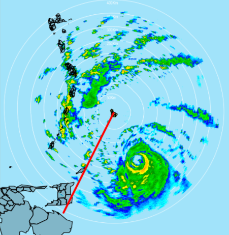
The core should pass well south of Barbados. The NHC are showing a very small swathe of hurricane force winds, and even if the wind field expands considerably, you should be far enough north. Radar is also showing the bulk of precipitation on the south side of the storm, it's that convection that helps mix the strong winds down to the surface. That being said be on your guard, prepare for the worst, hope for the best.
4 likes
-
Category5Kaiju

- Category 5
- Posts: 4326
- Joined: Thu Dec 24, 2020 12:45 pm
- Location: Seattle and Phoenix
Re: ATL: BERYL - Hurricane - Discussion
I’m going to bed. Going to check back in about 6 hours
0 likes
Unless explicitly stated, all info in my posts is based on my own opinions and observations. Tropical storms and hurricanes can be extremely dangerous. Refer to an accredited weather research agency or meteorologist if you need to make serious decisions regarding an approaching storm.
-
Keldeo1997
- Category 2
- Posts: 688
- Joined: Fri Oct 11, 2019 11:35 pm
Re: ATL: BERYL - Hurricane - Discussion

EWRC almost done
Last edited by Keldeo1997 on Mon Jul 01, 2024 12:25 am, edited 1 time in total.
1 likes
-
cheezyWXguy

- Category 5
- Posts: 6280
- Joined: Mon Feb 13, 2006 12:29 am
- Location: Dallas, TX
Re: ATL: BERYL - Hurricane - Discussion
Yes that radar presentation is interesting. Very narrow moat between the inner and outer eyewalls means dry air intrusions are probably less likely to prolong the erc. We could well wake up to a strengthening storm again
2 likes
Who is online
Users browsing this forum: No registered users and 12 guests