https://twitter.com/135knots/status/1770476216232951878
SIO: NEVILLE - Remnants
Moderator: S2k Moderators
-
Sciencerocks
- Category 5

- Posts: 7286
- Age: 38
- Joined: Thu Jul 06, 2017 1:51 am
-
Sciencerocks
- Category 5
- Posts: 7286
- Age: 38
- Joined: Thu Jul 06, 2017 1:51 am
-
Sciencerocks
- Category 5
- Posts: 7286
- Age: 38
- Joined: Thu Jul 06, 2017 1:51 am
-
cycloneye

- Admin

- Posts: 139082
- Age: 67
- Joined: Thu Oct 10, 2002 10:54 am
- Location: San Juan, Puerto Rico
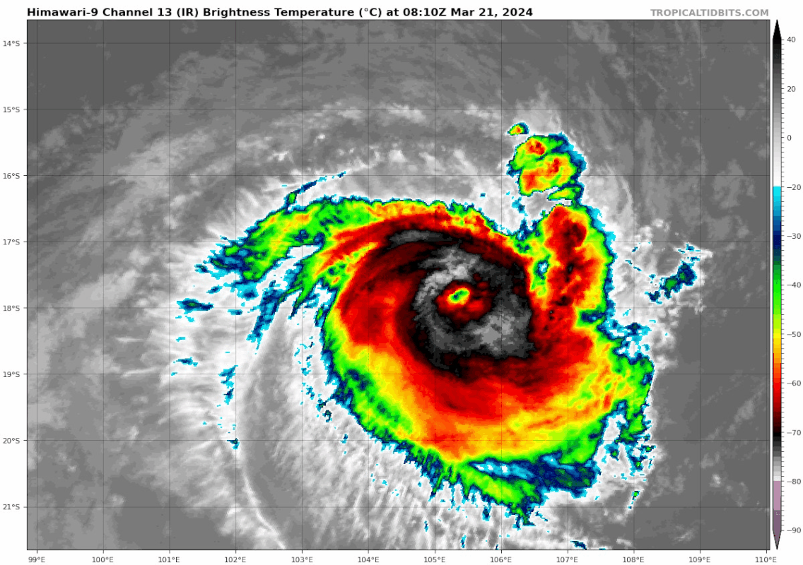
Re: SIO: NEVILLE - Tropical Cyclone
Clear eye.

2 likes
Visit the Caribbean-Central America Weather Thread where you can find at first post web cams,radars
and observations from Caribbean basin members Click Here
and observations from Caribbean basin members Click Here
-
cycloneye
- Admin
- Posts: 139082
- Age: 67
- Joined: Thu Oct 10, 2002 10:54 am
- Location: San Juan, Puerto Rico
Re: SIO: NEVILLE - Severe Tropical Cyclone
TROPICAL CYCLONE INFORMATION BULLETIN
Issued at 8:47 am WST on Thursday 21 March 2024
Severe Tropical Cyclone Neville (Category 3) was located at 8:00 am AWST near
17.9S 106.9E,
that is 880 km west northwest of Exmouth, and moving west southwest at 18
kilometres per hour.
Severe Tropical Cyclone Neville is continuing to intensify well northwest of
the Pilbara coast and is moving west, further away from the mainland. It is
expected to continue to move steadily west across the southern Indian Ocean and
is likely to intensify further during the next day or two.
By the weekend Neville is forecast to be moving over cooler waters and is
expected to begin to weaken as it moves to the south and southeast over open
waters.
Severe Tropical Cyclone Neville is not expected to impact mainland Australia.
0 likes
Visit the Caribbean-Central America Weather Thread where you can find at first post web cams,radars
and observations from Caribbean basin members Click Here
and observations from Caribbean basin members Click Here
-
Sciencerocks
- Category 5
- Posts: 7286
- Age: 38
- Joined: Thu Jul 06, 2017 1:51 am
-
Sciencerocks
- Category 5
- Posts: 7286
- Age: 38
- Joined: Thu Jul 06, 2017 1:51 am
-
cycloneye
- Admin
- Posts: 139082
- Age: 67
- Joined: Thu Oct 10, 2002 10:54 am
- Location: San Juan, Puerto Rico
Re: SIO: NEVILLE - Severe Tropical Cyclone
TROPICAL CYCLONE TECHNICAL BULLETIN: AUSTRALIA - WESTERN REGION
Issued by AUSTRALIAN BUREAU OF METEOROLOGY TROPICAL CYCLONE WARNING CENTRE
at: 0700 UTC 21/03/2024
Name: Severe Tropical Cyclone Neville
Identifier: 08U
Data At: 0600 UTC
Latitude: 17.9S
Longitude: 105.8E
Location Accuracy: within 15nm (30 km)
Movement Towards: west (270 deg)
Speed of Movement: 10 knots (19 km/h)
Maximum 10-Minute Wind: 70 knots (130 km/h)
Maximum 3-Second Wind Gust: 100 knots (185 km/h)
Central Pressure: 976 hPa
Radius of 34-knot winds NE quadrant: 40 nm (75 km)
Radius of 34-knot winds SE quadrant: 60 nm (110 km)
Radius of 34-knot winds SW quadrant: 60 nm (110 km)
Radius of 34-knot winds NW quadrant: 50 nm (95 km)
Radius of 48-knot winds NE quadrant: 25 nm (45 km)
Radius of 48-knot winds SE quadrant: 30 nm (55 km)
Radius of 48-knot winds SW quadrant: 30 nm (55 km)
Radius of 48-knot winds NW quadrant: 30 nm (55 km)
Radius of 64-knot winds: nm ( km)
Radius of Maximum Winds: 15 nm (30 km)
Dvorak Intensity Code: T4.5/4.5/D1.5/24HRS STT:S0.0/06HRS
Pressure of outermost isobar: 1006 hPa
Radius of outermost closed isobar: 160 nm (295 km)
FORECAST DATA
Date/Time : Location : Loc. Accuracy: Max Wind : Central Pressure
(UTC) : degrees : nm (km): knots(km/h): hPa
+06: 21/1200: 17.8S 104.8E: 030 (055): 075 (140): 971
+12: 21/1800: 17.7S 103.6E: 040 (075): 085 (155): 963
+18: 22/0000: 17.7S 102.4E: 045 (085): 090 (165): 959
+24: 22/0600: 17.8S 101.0E: 055 (100): 095 (175): 954
+36: 22/1800: 18.3S 98.0E: 065 (125): 095 (175): 952
+48: 23/0600: 19.2S 94.8E: 085 (160): 090 (165): 957
+60: 23/1800: 20.3S 91.9E: 110 (200): 070 (130): 973
+72: 24/0600: 21.0S 89.1E: 135 (250): 050 (095): 988
+96: 25/0600: 22.7S 85.0E: 195 (360): 030 (055): 1002
+120: 26/0600: 27.1S 87.2E: 290 (535): 030 (055): 1000
REMARKS:
Severe Tropical Cyclone Neville continues to show signs of development.
Although it has shown a fluctuating eye there has been a greater extent of cold
cloud tops associated with the system centre and convection today.
Position well defined on VIS and EIR. Microwave imagery has shown an impressive
eye signature in deep convection, however no high resolution low level (36-37
GHz) passes have scanned the system recently. In the three hours up to 0600UTC
Neville had an eye surrounded by very cold cloud tops (black to white in the
Dvorak scale). This eye has been obscured closer to analysis time.
Intensity estimated at 70kn based upon subjective Dvorak and recent DPRINT, in
addition to a trend forecast from this morning as the system has shown an
increase in convection both in terms of spatial (surrounding the system
including the weaker modelled northern side) and deeper with a larger extent of
colder cloud tops.
Dvorak analysis: DT =4.5 based on EIR eye pattern/VIS curved band 3-hour
average. This is consistent with MET/PAT=4.5 based on D+ 24h trend. FT/CI=4.5.
Objective guidance is very limited: No recent SATCON; ADT struggling to resolve
the correct scene (uniform/embedded) 53kn CI=3.4; AiDT 45kn. The DPRINT 76kn
(1-min average) objective guidance is consistent with analysis.
Wind structure has the hurricane force (>64kn) winds extending to all quadrants
due to the deep convection wrapping that has been observed over the past 3-6
hours. Otherwise structure is largely maintained from previous forecasts with
slight asymmetry present favouring winds on the southern side. RMW=15nm.
Neville is pouched in a moist environment surrounded by dry air. CIMSS upper
wind analyses indicate that vertical shear has reduced to 10-12kn NE'ly.
Further intensification is forecast in line with most NWP guidance although
there is considerable spread as to the extent of this. Also worth noting that
model guidance is not analysing Neville to be as strong at model initialisation
which is likely to impact the intensity forecast from models. The main
inhibiting factors for rapid intensification are relatively weak upper outflow
and only moderate SSTs. Factors in favour of rapid intensification are small
system size and low shear environment which protects the system from the
surrounding dry air. A more well-defined eye could lead to a more rapid
intensification and the development of colder cloud tops during the diurnally
less favourable period today suggests that intensification to category 4 is now
more likely than not. Category 5 intensity could be reached later on Friday or
early Saturday, however is deemed unlikely.
A steering ridge to the south should ensure a consistent westerly track but in
the longer term the ridge should weaken and Neville is forecast to turn to the
southwest and then southeast. As it moves to the south it is forecast to weaken
rapidly as it moves over cooler SSTs and is affected by increasing vertical
wind shear and begins to ingest the surrounding dry air.
0 likes
Visit the Caribbean-Central America Weather Thread where you can find at first post web cams,radars
and observations from Caribbean basin members Click Here
and observations from Caribbean basin members Click Here
-
cycloneye
- Admin
- Posts: 139082
- Age: 67
- Joined: Thu Oct 10, 2002 10:54 am
- Location: San Juan, Puerto Rico
Re: SIO: NEVILLE - Severe Tropical Cyclone
TROPICAL CYCLONE TECHNICAL BULLETIN: AUSTRALIA - WESTERN REGION
Issued by AUSTRALIAN BUREAU OF METEOROLOGY TROPICAL CYCLONE WARNING CENTRE
at: 1313 UTC 21/03/2024
Name: Severe Tropical Cyclone Neville
Identifier: 08U
Data At: 1200 UTC
Latitude: 17.8S
Longitude: 104.7E
Location Accuracy: within 10nm (20 km)
Movement Towards: west (275 deg)
Speed of Movement: 11 knots (20 km/h)
Maximum 10-Minute Wind: 85 knots (155 km/h)
Maximum 3-Second Wind Gust: 120 knots (220 km/h)
Central Pressure: 963 hPa
Radius of 34-knot winds NE quadrant: 40 nm (75 km)
Radius of 34-knot winds SE quadrant: 70 nm (130 km)
Radius of 34-knot winds SW quadrant: 70 nm (130 km)
Radius of 34-knot winds NW quadrant: 50 nm (95 km)
Radius of 48-knot winds NE quadrant: 25 nm (45 km)
Radius of 48-knot winds SE quadrant: 30 nm (55 km)
Radius of 48-knot winds SW quadrant: 30 nm (55 km)
Radius of 48-knot winds NW quadrant: 30 nm (55 km)
Radius of 64-knot winds: 20 nm (35 km)
Radius of Maximum Winds: 10 nm (20 km)
Dvorak Intensity Code: T5.5/5.5/D2.0/24HRS STT:D1.0/06HRS
Pressure of outermost isobar: 1006 hPa
Radius of outermost closed isobar: 150 nm (280 km)
FORECAST DATA
Date/Time : Location : Loc. Accuracy: Max Wind : Central Pressure
(UTC) : degrees : nm (km): knots(km/h): hPa
+06: 21/1800: 17.7S 103.5E: 025 (045): 090 (165): 959
+12: 22/0000: 17.7S 102.2E: 035 (070): 095 (175): 954
+18: 22/0600: 17.8S 100.8E: 045 (085): 100 (185): 949
+24: 22/1200: 18.0S 99.4E: 055 (100): 100 (185): 949
+36: 23/0000: 18.6S 96.3E: 065 (125): 100 (185): 948
+48: 23/1200: 19.6S 93.1E: 090 (165): 085 (155): 961
+60: 24/0000: 20.5S 90.2E: 110 (205): 060 (110): 981
+72: 24/1200: 21.0S 87.4E: 130 (245): 040 (075): 995
+96: 25/1200: 23.5S 84.0E: 200 (370): 030 (055): 1000
+120: 26/1200: : : :
REMARKS:
Severe Tropical Cyclone Neville intensifying rapidly.
Position well defined with a clear eye on EIR and microwave imagery.
DT=5.5 based on EIR eye pattern with LG surrounding shade and OW/B eye
adjustment. MET/PAT 5.0 based on D+ 24h trend. FT/CI=5.5 based on DT. Objective
guidance has generally been underestimating intensity however these
discrepancies are reducing. No recent SATCON; ADT 87kn; AiDT 75kn and DPRINT
83kn (all 1-min average). Intensity estimated at 85kn, slightly below
subjective Dvorak.
Structure is largely maintained from previous forecasts with slight asymmetry
present favouring winds on the southern side. RMW=12nm based on inner edge of
deepest convection surrounding the clear eye which has a radius of
approximately 7nm.
Neville is pouched in a moist environment surrounded by dry air. CIMSS upper
wind analyses indicate that vertical shear has reduced below 10kn.
Further intensification is forecast in line with the trend of most NWP
guidance. Though most model guidance is underestimating Neville's intensity at
model initialisation and peak forecast intensities are near or below the
currently analysed intensity. The main inhibiting factors for rapid
intensification are relatively weak upper outflow and only moderate SSTs.
Factors in favour of further rapid intensification are small system size and
low shear environment which protects the system from the surrounding dry air.
Neville is forecast to reach category 4 intensity. Even category 5 intensity
could be reached on Friday or early Saturday if further rapid intensification
does occur.
A steering ridge to the south should ensure a consistent westerly track but in
the longer term the ridge should weaken and Neville is forecast to turn to the
southwest and then southeast. As it moves to the south it is forecast to weaken
rapidly as it moves over cooler SSTs and is affected by increasing vertical
wind shear and begins to ingest the surrounding dry air.
0 likes
Visit the Caribbean-Central America Weather Thread where you can find at first post web cams,radars
and observations from Caribbean basin members Click Here
and observations from Caribbean basin members Click Here

-
Sciencerocks
- Category 5
- Posts: 7286
- Age: 38
- Joined: Thu Jul 06, 2017 1:51 am
-
Sciencerocks
- Category 5
- Posts: 7286
- Age: 38
- Joined: Thu Jul 06, 2017 1:51 am
-
Hurricane2022

- Category 4

- Posts: 921
- Joined: Tue Aug 23, 2022 11:38 pm
- Location: Araçatuba, Brazil
Re: SIO: NEVILLE - Severe Tropical Cyclone
It looks like a bit of NE shear is affecting the small Cyclone Neville right now.

It's worth remembering that just a little bit of shear can be enough to decapitate tiny cyclones like this, given that they are always subject to rapid changes in intensity, up or down. But I still expect Neville to continue intensifying until tomorrow night or Saturday morning, and there it will find a combo of dry air, shear and cold waters that will take it to its final destination.
It's worth remembering that just a little bit of shear can be enough to decapitate tiny cyclones like this, given that they are always subject to rapid changes in intensity, up or down. But I still expect Neville to continue intensifying until tomorrow night or Saturday morning, and there it will find a combo of dry air, shear and cold waters that will take it to its final destination.
0 likes
Sorry for the bad English sometimes...!
For reliable and detailed information for any meteorological phenomenon, please consult the National Hurricane Center, Joint Typhoon Warning Center , or your local Meteo Center.
--------
Una cvm Christo, pro Christo, et in Christo. Sit nomen Domini benedictvm.
For reliable and detailed information for any meteorological phenomenon, please consult the National Hurricane Center, Joint Typhoon Warning Center , or your local Meteo Center.
--------
Una cvm Christo, pro Christo, et in Christo. Sit nomen Domini benedictvm.
-
cycloneye
- Admin
- Posts: 139082
- Age: 67
- Joined: Thu Oct 10, 2002 10:54 am
- Location: San Juan, Puerto Rico
Re: SIO: NEVILLE - Severe Tropical Cyclone
Looks like it has peaked at 115kt.
18S NEVILLE 240322 0000 17.9S 102.6E SHEM 115 948
0 likes
Visit the Caribbean-Central America Weather Thread where you can find at first post web cams,radars
and observations from Caribbean basin members Click Here
and observations from Caribbean basin members Click Here

Re: SIO: NEVILLE - Severe Tropical Cyclone
It's so over for neville
0 likes
blonde stacey (xe/xem/xir)
-
cycloneye
- Admin
- Posts: 139082
- Age: 67
- Joined: Thu Oct 10, 2002 10:54 am
- Location: San Juan, Puerto Rico
Re: SIO: NEVILLE - Severe Tropical Cyclone
0 likes
Visit the Caribbean-Central America Weather Thread where you can find at first post web cams,radars
and observations from Caribbean basin members Click Here
and observations from Caribbean basin members Click Here
-
cycloneye
- Admin
- Posts: 139082
- Age: 67
- Joined: Thu Oct 10, 2002 10:54 am
- Location: San Juan, Puerto Rico
Re: SIO: NEVILLE - Severe Tropical Cyclone
TROPICAL CYCLONE TECHNICAL BULLETIN: AUSTRALIA - WESTERN REGION
Issued by AUSTRALIAN BUREAU OF METEOROLOGY TROPICAL CYCLONE WARNING CENTRE
at: 1247 UTC 22/03/2024
Name: Severe Tropical Cyclone Neville
Identifier: 08U
Data At: 1200 UTC
Latitude: 18.5S
Longitude: 99.4E
Location Accuracy: within 10nm (20 km)
Movement Towards: west southwest (257 deg)
Speed of Movement: 16 knots (29 km/h)
Maximum 10-Minute Wind: 90 knots (165 km/h)
Maximum 3-Second Wind Gust: 125 knots (230 km/h)
Central Pressure: 955 hPa
Radius of 34-knot winds NE quadrant: 40 nm (75 km)
Radius of 34-knot winds SE quadrant: 80 nm (150 km)
Radius of 34-knot winds SW quadrant: 70 nm (130 km)
Radius of 34-knot winds NW quadrant: 30 nm (55 km)
Radius of 48-knot winds NE quadrant: 25 nm (45 km)
Radius of 48-knot winds SE quadrant: 30 nm (55 km)
Radius of 48-knot winds SW quadrant: 30 nm (55 km)
Radius of 48-knot winds NW quadrant: 20 nm (35 km)
Radius of 64-knot winds: 20 nm (35 km)
Radius of Maximum Winds: 15 nm (25 km)
Dvorak Intensity Code: T4.5/5.5/W1.0/24HRS STT:W1.0/06HRS
Pressure of outermost isobar: 1004 hPa
Radius of outermost closed isobar: 100 nm (185 km)
FORECAST DATA
Date/Time : Location : Loc. Accuracy: Max Wind : Central Pressure
(UTC) : degrees : nm (km): knots(km/h): hPa
+06: 22/1800: 18.7S 98.0E: 025 (045): 085 (155): 959
+12: 23/0000: 19.1S 96.4E: 035 (070): 080 (150): 964
+18: 23/0600: 19.7S 94.8E: 045 (080): 075 (140): 968
+24: 23/1200: 20.3S 93.5E: 050 (090): 070 (130): 971
+36: 24/0000: 21.4S 90.9E: 065 (115): 055 (100): 982
+48: 24/1200: 22.2S 88.5E: 085 (155): 040 (075): 992
+60: 25/0000: 23.0S 86.3E: 105 (195): 030 (055): 999
+72: 25/1200: 25.0S 85.2E: 140 (260): 030 (055): 998
+96: 26/1200: 33.2S 93.9E: 185 (345): 030 (055): 998
+120: 27/1200: : : :
REMARKS:
Severe Tropical Cyclone Neville is continuing to show signs of weakening. The
eye has become less discernible, more elongated, and generally slightly cooler
over the past 6 hours. The effect of increasing northerly vertical wind shear
is apparent in the tighter temperature gradient on the northern side of the
CDO, which has also become less circular in recent hours.
Confidence in the analysis position remains good with a somewhat discernible
eye persisting on EIR imagery, and assisted by recent microwave passes.
Dvorak DT has been averaging 4.5 over 3 hours, based on recent EIR eye patterns
with LG surrounding shade and LG/B eye adjustment, though some images have the
eye temperature warmer at MG. An embedded centre pattern with LG surround was
applied to the most recent image with the eye becoming less discernible, also
yielding DT 4.5. MET is 4.5 based on a 24 hour W trend, with no PT adjustment.
FT = 4.5, and CI is held up at 5.5 for initial weakening. Recent objective
guidance is also generally indicating a weakening trend: SATCON 80 kn; ADT
79kn; AiDT 80kn and DPRINT 97kn (all 1-min average). Intensity set at 90kn,
biased towards subjective Dvorak, with some agreement with objective guidance.
Structure continues to be extrapolated from the SAR pass at 2237UTC Thursday,
still with slight asymmetry favouring winds on the southern side.
Neville is pouched in a moist environment surrounded by dry air. CIMSS upper
wind analyses indicate that vertical wind shear has increased to around 20
knots northeasterly. SSTs remain between 26-27C until 25S where cooler waters
lie.
A steering ridge to the south should ensure a consistent west-southwesterly
track in the short to medium term. Over the weekend, increasing northerly shear
from an upper trough to the west is likely to enable dry air to intrude, and
the system is expected to continue to weaken. The forecast is for a gradual
weakening in line with recent NWP guidance. In the longer term, the ridge
should weaken, and Neville is forecast to turn to the southwest and then
southeast. As it moves south, it is forecast to weaken further as it moves over
cooler SSTs.
0 likes
Visit the Caribbean-Central America Weather Thread where you can find at first post web cams,radars
and observations from Caribbean basin members Click Here
and observations from Caribbean basin members Click Here
-
cycloneye
- Admin
- Posts: 139082
- Age: 67
- Joined: Thu Oct 10, 2002 10:54 am
- Location: San Juan, Puerto Rico
Re: SIO: NEVILLE - Tropical Cyclone
TROPICAL CYCLONE INFORMATION BULLETIN
Issued at 2:39 am WST on Sunday 24 March 2024
Tropical Cyclone Neville (Category 2) was located at 2:00 am AWST near 21.0S
92.6E,
that is 1080 km south southwest of Cocos (Keeling) Islands moving west
southwest at 21 kilometres per hour.
Tropical Cyclone Neville is moving steadily to the west-southwest over open
waters in the Indian Ocean, away from the Australian mainland.
Neville is continuing to weaken as conditions become more unfavourable. The
system is expected to weaken below tropical cyclone strength later today or
early Monday as it moves to the south over cooler waters.
0 likes
Visit the Caribbean-Central America Weather Thread where you can find at first post web cams,radars
and observations from Caribbean basin members Click Here
and observations from Caribbean basin members Click Here
-
cycloneye
- Admin
- Posts: 139082
- Age: 67
- Joined: Thu Oct 10, 2002 10:54 am
- Location: San Juan, Puerto Rico
Re: SIO: NEVILLE - Remnants
TROPICAL CYCLONE INFORMATION BULLETIN
Issued at 2:46 pm WST on Sunday 24 March 2024
Ex-Tropical Cyclone Neville was located at 2:00 pm AWST near 22.6S 90.2E,
that is 1360 km south southwest of Cocos (Keeling) Islands moving southwest at
25 kilometres per hour.
Ex-Tropical Cyclone Neville is rapidly weakening in the Indian Ocean.
No further Information Bulletins will be issued.
0 likes
Visit the Caribbean-Central America Weather Thread where you can find at first post web cams,radars
and observations from Caribbean basin members Click Here
and observations from Caribbean basin members Click Here
Who is online
Users browsing this forum: No registered users and 47 guests