NATL: MELISSA - Aftermath - Discussion

Moderator: S2k Moderators

Message
Author
CrazyC83
Professional-Met
Professional-Met
Posts: 34306
Joined: Tue Mar 07, 2006 11:57 pm
Location: Deep South, for the first time!

Re: NATL: MELISSA - Aftermath - Discussion

#3001 Postby CrazyC83 » Sun Nov 02, 2025 7:21 pm

MarioProtVI wrote:I thought Milton wouldn’t be outdone for a while but apparently Melissa decided to do just that this year :lol: but Milton’s EI episode still puts it a little over Melissa, but for the most part they’re basically tied for the most insane episodes of TC tracking that I’ve experienced. Good riddance to Melissa especially though, she ain’t coming back :spam:


In some ways, the evolution reminded me of Haiyan. In both cases, they didn't explode like Patricia, Milton or some WPAC storms, and instead had an initial RI period, followed by continued steady intensification and the whole process lasted 3+ days.
15 likes   

User avatar
FireRat
Category 5
Category 5
Posts: 1274
Age: 38
Joined: Sun Sep 26, 2010 11:38 pm
Location: North Carolina

Re: NATL: MELISSA - Aftermath - Discussion

#3002 Postby FireRat » Mon Nov 03, 2025 3:51 am

2025 saved its worst monster for last. 3rd Cat 5, and in a messed up version of "three times the charm", this 3rd and worst Cat 5 of the season hit land.

It was crazy to watch Melissa patiently slither like a snake near Jamaica for days, preparing to deal its devastating strike, at maximum intensity! :double:

What a BEAST, truly the defining storm of this unusually tricky season. Can't believe it was almost November when we got to see Labor Day '35 get rivaled.
'25 will forever live in infamy for all-time landfalls in the whole Atlantic basin. We now have a good idea what Labor Day could've looked like and how violent it could've been at landfall thanks to Melissa.

Imagine if Melissa gets upgraded wind-wise, might make a case for Labor Day ro regain its old 200 mph estimate.
Indeed, what a WOW moment this late season!
5 likes   
Georges '98, Irene '99, Frances '04, Jeanne '04, Katrina '05, Wilma '05, Gustav '08, Isaac '12, Matthew '16, Florence '18, Michael '18, Ian '22

ncforecaster89
Category 1
Category 1
Posts: 258
Age: 55
Joined: Sat Oct 20, 2018 12:32 pm
Contact:

Re: NATL: MELISSA - Post-Tropical - Discussion

#3003 Postby ncforecaster89 » Mon Nov 03, 2025 5:09 pm

Ubuntwo wrote:
CrazyC83 wrote:The size of the RMW was about 7 nautical miles? That would provide a starting point.

The 172 kt dropsonde deserves some weight in the sample, although the 179 kt SFMR definitely should be ignored.

The 172kt measurement was instantaneous, a standard reduction of the 150m averaged wind (188kt) translates to 156kt 1-min sustained surface winds. That is at one point in the storm, though, and not the strongest quad, which was likely part of the NHC's justification for jumping to 160kt.

Another data point is KZC analysis, which comes out to 166.7kt for the recon-measured 892mb peak.


I see you’ve already clarified how the 172 kt dropsonde wind is an instantaneous gust and doesn’t correlate to a direct MSW.

I feel the WL150 winds is the most reliable measurement of the MSW as it provides the best representation of how well the 700 mb FLWs are mixing down to the surface…which in this case matches perfectly with the standard 90% FLW reduction factor to arrive at 155 kt.

But, as you also mentioned, it’s conceivable that stronger winds may have been found in the unsampled NE quadrant of the eyewall and that’s why I went as high as 165 kt for the assumed MSW at the peak (13-14z) even though there’s no actual in-situ data supportive of an intensity that high.

The much more difficult question, in my opinion, pertains to the landfall intensity as it certainly didn’t retain its peak through the subsequent 3-4 hours, thereafter, to landfall. The 2 mb rise in the central pressure between the last two passes through the eye (only 45 minutes apart) make that abundantly clear, as does the notable degradation of the satellite presentation after 14z…which was also reflected in the various satellite intensity estimates (such as ADT calculating a possibly conservative 7 mb increase in the pressure). Although a reasonable case could be made for 150 kt/902 mb if we were to simply extrapolate out the pressure increase between the aforementioned RECON flights, I still feel 155kt/899 mb is a better reflection of Melissa’s likely strength at landfall barring any other data becoming available in the future.
3 likes   

ljmac75
Tropical Storm
Tropical Storm
Posts: 183
Joined: Fri Apr 28, 2023 12:30 am

Re: NATL: MELISSA - Aftermath - Discussion

#3004 Postby ljmac75 » Mon Nov 03, 2025 8:50 pm

1 likes   

User avatar
GCANE
S2K Supporter
S2K Supporter
Posts: 12072
Joined: Mon Oct 22, 2007 8:03 am

Re: NATL: MELISSA - Aftermath - Discussion

#3005 Postby GCANE » Tue Nov 04, 2025 2:00 pm

1 likes   

User avatar
GCANE
S2K Supporter
S2K Supporter
Posts: 12072
Joined: Mon Oct 22, 2007 8:03 am

Re: NATL: MELISSA - Aftermath - Discussion

#3006 Postby GCANE » Tue Nov 04, 2025 2:04 pm

PERILS OF A SLOW-MOVING STORM : THE IMPACT OF HURRICANE MELISSA ON JAMAICA

https://www.youtube.com/watch?v=nOFcdcmSB0o
1 likes   

User avatar
Easterlywave
Tropical Wave
Tropical Wave
Posts: 3
Age: 78
Joined: Wed Oct 29, 2025 11:55 am
Contact:

Re: NATL: MELISSA - Post-Tropical - Discussion

#3007 Postby Easterlywave » Wed Nov 05, 2025 7:21 am

ncforecaster89 wrote:
ljmac75 wrote:Some assorted thoughts on the intensity:
Lastly, a pressure in the 930’s measured from just outside of the eye (within 2 n mi) wouldn’t even come close to supporting a minimum central pressure of < 900 mb. For example, a pressure of 942 mb was recorded at a distance of 2 n mi from just outside the eye of hurricane Andrew (at the innermost portion of the eastern eyewall, as well). It’s also important to mention that unlike with Melissa, hurricane Andrew was still strengthening rapidly through landfall and I’d argue that 150 kt is a far more accurate assessment of its true intensity. Using that as a proxy, you’d need a pressure no greater than 919 mb to make the assumption that Melissa might’ve contained a minimum central pressure of 899 mb.


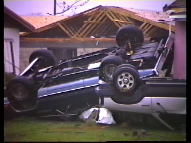
As a frame of reference - We were 2 1/2 miles from the northern edge of Andrew's 922 mb eye, and recorded that 942 mb. Stanley Goldenberg, about 1 1/4 miles from the eye recorded 932 mb. The wind at our location was sustained at 145 mph, with gusts of 175 mph. Image
5 likes   
A Pioneer of hurricane chasing: 1966---> Created the 1st. hurricane and storm chasing business ever: 1982. https://www.canebeard.com/hurricane_chaser.html

ncforecaster89
Category 1
Category 1
Posts: 258
Age: 55
Joined: Sat Oct 20, 2018 12:32 pm
Contact:

Re: NATL: MELISSA - Post-Tropical - Discussion

#3008 Postby ncforecaster89 » Wed Nov 05, 2025 8:19 pm

Easterlywave wrote:
ncforecaster89 wrote:
ljmac75 wrote:Some assorted thoughts on the intensity:
Lastly, a pressure in the 930’s measured from just outside of the eye (within 2 n mi) wouldn’t even come close to supporting a minimum central pressure of < 900 mb. For example, a pressure of 942 mb was recorded at a distance of 2 n mi from just outside the eye of hurricane Andrew (at the innermost portion of the eastern eyewall, as well). It’s also important to mention that unlike with Melissa, hurricane Andrew was still strengthening rapidly through landfall and I’d argue that 150 kt is a far more accurate assessment of its true intensity. Using that as a proxy, you’d need a pressure no greater than 919 mb to make the assumption that Melissa might’ve contained a minimum central pressure of 899 mb.


As a frame of reference - We were 2 1/2 miles from the northern edge of Andrew's 922 mb eye, and recorded that 942 mb. Stanley Goldenberg, about 1 1/4 miles from the eye recorded 932 mb. The wind at our location was sustained at 145 mph, with gusts of 175 mph. [url]https://i.postimg.cc/s1FsSFnh/carsover.jpg [/url]


It’s most probable you actually saw stronger wind gusts than 175 mph.

As I mentioned above, it’s likely that Andrew crossed the shoreline with MSWs of 150 kt. Given your distance from the immediate coast, you can figure a reduction factor of 0.85 on the MSW…which equates to 127.5 kt (right in line with the estimate you noted). The gust factor would be closer to 1.3 which puts it at 165.8 kt or 190.6 mph. The only real difference in the two respective estimates is the associated gust factor (1.2 vs 1.3). The typical gust factor used for the immediate coastline is 1.23, so a gust factor of 1.2 is too low based on recent studies.
1 likes   

User avatar
kevin
Category 5
Category 5
Posts: 2878
Age: 27
Joined: Wed Aug 28, 2019 4:35 am

Re: NATL: MELISSA - Aftermath - Discussion

#3009 Postby kevin » Thu Nov 06, 2025 8:16 am

The number of deaths caused by Melissa on Jamaica is now 35 and still rising with an unknown number of people missing. Unfortunately, as expected, this makes Melissa one of the deadliest hurricanes in Jamaica in the recorded database (1851 - now) and the deadliest since Gilbert (using the current death toll). Here are the other most destructive hurricanes in Jamaica since 1851.

Hurricane / Year / Death toll
Charlie / 1951 / 152
1912 Jamaica hurricane / 1912 / 100
1903 Jamaica hurricane / 1903 / 65
Gilbert / 1988 / 45
Tropical Depression One / 1979 / 41
Melissa / 2025 / 35

Edit: Updated Charlie's year to 1951.
Last edited by kevin on Thu Nov 06, 2025 10:56 am, edited 1 time in total.
1 likes   

LarryWx
S2K Supporter
S2K Supporter
Posts: 6854
Joined: Sun Sep 07, 2003 2:04 pm
Location: GA

Re: NATL: MELISSA - Aftermath - Discussion

#3010 Postby LarryWx » Thu Nov 06, 2025 9:28 am

kevin wrote:The number of deaths caused by Melissa on Jamaica is now 35 and still rising with an unknown number of people missing. Unfortunately, as expected, this makes Melissa one of the deadliest hurricanes in Jamaica in the recorded database (1851 - now) and the deadliest since Gilbert (using the current death toll). Here are the other most destructive hurricanes in Jamaica since 1851.

Hurricane / Year / Death toll
Charlie / 1952 / 152
1912 Jamaica hurricane / 1912 / 100
1903 Jamaica hurricane / 1903 / 65
Gilbert / 1988 / 45
Tropical Depression One / 1979 / 41
Melissa / 2025 / 35


Hey Kevin,
This is sad to hear but not at all surprising. I hope not but fear that even Charlie’s 152 may eventually be exceeded.

Aside: You have a typo as the Charlie that hit Jamaica was
the one in 1951 rather than the one in 1952.
2 likes   
Personal Forecast Disclaimer:
The posts in this forum are NOT official forecasts and should not be used as such. They are just the opinion of the poster and may or may not be backed by sound meteorological data. They are NOT endorsed by any professional institution or storm2k.org. For official information, please refer to the NHC and NWS products.

User avatar
Teban54
Category 5
Category 5
Posts: 3785
Joined: Sat May 19, 2018 1:19 pm

Re: NATL: MELISSA - Aftermath - Discussion

#3011 Postby Teban54 » Thu Nov 06, 2025 10:08 am

LarryWx wrote:
kevin wrote:The number of deaths caused by Melissa on Jamaica is now 35 and still rising with an unknown number of people missing. Unfortunately, as expected, this makes Melissa one of the deadliest hurricanes in Jamaica in the recorded database (1851 - now) and the deadliest since Gilbert (using the current death toll). Here are the other most destructive hurricanes in Jamaica since 1851.

Hurricane / Year / Death toll
Charlie / 1952 / 152
1912 Jamaica hurricane / 1912 / 100
1903 Jamaica hurricane / 1903 / 65
Gilbert / 1988 / 45
Tropical Depression One / 1979 / 41
Melissa / 2025 / 35


Hey Kevin,
This is sad to hear but not at all surprising. I hope not but fear that even Charlie’s 152 may eventually be exceeded.

Aside: You have a typo as the Charlie that hit Jamaica was
the one in 1951 rather than the one in 1952.

I'm surprised how obscure Charlie 1951 was, despite its impacts on Jamaica. The name Charlie was technically from the phonetic alphabet for the 1950-1952 seasons, not a list of human names, and it predated the practice of retiring names.

It must have been bizarre to some Jamaican residents, especially older generations that went through Charlie 1951, when Charley 2004 passed just west of Jamaica (even though it was "just" a Cat 1 and obviously not what Charley was eventually remembered for).
1 likes   

User avatar
cycloneye
Admin
Admin
Posts: 148543
Age: 69
Joined: Thu Oct 10, 2002 10:54 am
Location: San Juan, Puerto Rico

Re: NATL: MELISSA - Aftermath - Discussion

#3012 Postby cycloneye » Thu Nov 06, 2025 1:11 pm

Hurricane2022, moveed the thread to the 2025 archives forum so the members can continue the discussions and analysis of Melissa and of course waiting for the TCR.
0 likes   
Visit the Caribbean-Central America Weather Thread where you can find at first post web cams,radars
and observations from Caribbean basin members Click Here

User avatar
cycloneye
Admin
Admin
Posts: 148543
Age: 69
Joined: Thu Oct 10, 2002 10:54 am
Location: San Juan, Puerto Rico

Re: NATL: MELISSA - Aftermath - Discussion

#3013 Postby cycloneye » Thu Nov 06, 2025 1:14 pm

4 likes   
Visit the Caribbean-Central America Weather Thread where you can find at first post web cams,radars
and observations from Caribbean basin members Click Here

User avatar
cycloneye
Admin
Admin
Posts: 148543
Age: 69
Joined: Thu Oct 10, 2002 10:54 am
Location: San Juan, Puerto Rico

Re: NATL: MELISSA - Aftermath - Discussion

#3014 Postby cycloneye » Sun Nov 09, 2025 6:41 pm

This is great to see that things are slowly but surely returning to normal.

 https://x.com/JamaicaGleaner/status/1987665155891630288

1 likes   
Visit the Caribbean-Central America Weather Thread where you can find at first post web cams,radars
and observations from Caribbean basin members Click Here

User avatar
cycloneye
Admin
Admin
Posts: 148543
Age: 69
Joined: Thu Oct 10, 2002 10:54 am
Location: San Juan, Puerto Rico

Re: NATL: MELISSA - Aftermath - Discussion

#3015 Postby cycloneye » Mon Nov 10, 2025 3:29 pm

2 likes   
Visit the Caribbean-Central America Weather Thread where you can find at first post web cams,radars
and observations from Caribbean basin members Click Here

ljmac75
Tropical Storm
Tropical Storm
Posts: 183
Joined: Fri Apr 28, 2023 12:30 am

Re: NATL: MELISSA - Aftermath - Discussion

#3016 Postby ljmac75 » Mon Nov 10, 2025 9:58 pm


Looks like they're only a little west of the Kingston area. I'm glad the leaves are coming back but this isn't from a super badly hit area.
1 likes   

User avatar
cycloneye
Admin
Admin
Posts: 148543
Age: 69
Joined: Thu Oct 10, 2002 10:54 am
Location: San Juan, Puerto Rico

Re: NATL: MELISSA - Aftermath - Discussion

#3017 Postby cycloneye » Tue Nov 11, 2025 6:11 am

Looking forward to all of what he will release that will be very interesting.

 https://x.com/iCyclone/status/1988151018023215182

4 likes   
Visit the Caribbean-Central America Weather Thread where you can find at first post web cams,radars
and observations from Caribbean basin members Click Here

User avatar
cycloneye
Admin
Admin
Posts: 148543
Age: 69
Joined: Thu Oct 10, 2002 10:54 am
Location: San Juan, Puerto Rico

Re: NATL: MELISSA - Aftermath - Discussion

#3018 Postby cycloneye » Tue Nov 11, 2025 12:04 pm

Sad news as the death toll has risen to 45.

 https://x.com/JamaicaObserver/status/1988291466486292861

1 likes   
Visit the Caribbean-Central America Weather Thread where you can find at first post web cams,radars
and observations from Caribbean basin members Click Here

User avatar
Jr0d
S2K Supporter
S2K Supporter
Posts: 1471
Joined: Tue Aug 27, 2019 10:52 am
Location: Cayo Hueso

Re: NATL: MELISSA - Aftermath - Discussion

#3019 Postby Jr0d » Tue Nov 11, 2025 12:55 pm

This is heartbreaking.


Link: https://youtube.com/watch?v=PmNgMNOcpSQ
0 likes   

User avatar
cycloneye
Admin
Admin
Posts: 148543
Age: 69
Joined: Thu Oct 10, 2002 10:54 am
Location: San Juan, Puerto Rico

Re: NATL: MELISSA - Aftermath - Discussion

#3020 Postby cycloneye » Wed Nov 12, 2025 6:17 am

Josh apart from his chasing thing, he cares for people in need. Waiting to see his data and video.

 https://x.com/iCyclone/status/1988562054396166449

1 likes   
Visit the Caribbean-Central America Weather Thread where you can find at first post web cams,radars
and observations from Caribbean basin members Click Here


Return to “2025”

Who is online

Users browsing this forum: No registered users and 26 guests