NATL: IMELDA - Models

Moderator: S2k Moderators

Message
Author
User avatar
ronjon
Category 5
Category 5
Posts: 4882
Joined: Fri Aug 19, 2005 5:17 pm
Location: Hernando Beach, FL

Re: NATL: INVEST 94L - Models

#181 Postby ronjon » Thu Sep 25, 2025 6:42 pm

MetroMike wrote:The 18Z Gfs has only a 997mb low at landfall. I don't know why on Tropical Tidbits models it has been losing the MB # in certain systems from time to time.


Yeah I noticed that too metro. Although thought I counted 8 2mb interval contours from the 1002 mb line which would be 986 mb??
1 likes   

User avatar
ConvergenceZone
Category 5
Category 5
Posts: 5238
Joined: Fri Jul 29, 2005 1:40 am
Location: Northern California

Re: NATL: INVEST 94L - Models

#182 Postby ConvergenceZone » Thu Sep 25, 2025 6:46 pm

MetroMike wrote:The 18Z Gfs has only a 997mb low at landfall. I don't know why on Tropical Tidbits models it has been losing the MB # in certain systems from time to time.


Wow that's weak, but then again I don't think any of the models are bombing this thing out, but even so, if it stalls or moves slowly, it could still be a horrible rain event.
0 likes   

User avatar
Teban54
Category 5
Category 5
Posts: 3579
Joined: Sat May 19, 2018 1:19 pm

Re: NATL: INVEST 94L - Models

#183 Postby Teban54 » Thu Sep 25, 2025 6:53 pm

Reminder: The last Imelda in 2019 peaked at 40 kts, and only retained tropical storm intensity for 9 hours during its entire lifetime. But it was the 4th wettest TC in Texas, with $5 billion in damage.
4 likes   

User avatar
Blown Away
S2K Supporter
S2K Supporter
Posts: 10233
Joined: Wed May 26, 2004 6:17 am

Re: NATL: INVEST 94L - Models

#184 Postby Blown Away » Thu Sep 25, 2025 6:56 pm

Most of the 18z model intensity trending down to strong TS to Cat 1.
0 likes   
Hurricane Eye Experience: David 79, Irene 99, Frances 04, Jeanne 04, Wilma 05… Hurricane Brush Experience: Andrew 92, Erin 95, Floyd 99, Matthew 16, Irma 17, Ian 22, Nicole 22…

User avatar
Zonacane
Category 1
Category 1
Posts: 402
Joined: Tue Aug 03, 2021 2:23 pm

Re: NATL: INVEST 94L - Models

#185 Postby Zonacane » Thu Sep 25, 2025 6:58 pm

Models are trending down because Imelda is a mess and takes a long time to consolidate properly
2 likes   

User avatar
chaser1
S2K Supporter
S2K Supporter
Posts: 5718
Age: 64
Joined: Sat Oct 15, 2005 5:59 pm
Location: Longwood, Fl

Re: NATL: INVEST 94L - Models

#186 Postby chaser1 » Thu Sep 25, 2025 7:07 pm

Whelp, I'm jumping on the NAM bandwagon and I know what ya'll are thinking :yayaya:

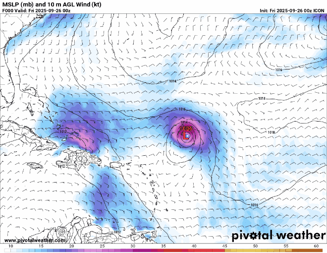
I'll tell you why. I don't think the models have handled 94L genesis all too well. Add 94L continuing to entangle itself with Hispanola and/or upper level shear for at least another day or two. Someone already mentioned that it appeared that had ICON's 18Z model run continued past 120 hr, it looked as if 94L was about to feel Humberto's tug and begin a NNE (and then N.E.) motion.
Looks to me that this solution is favored by ICON, CMC, NAVGEM, and yes... NAM as well. I think a quicker developing 94L would be stronger and apt to feel the CONUS trough and threaten S. Carolina. I think a slow to develop weak (Wave, T.D., T.S.) system will be apt to simply have its mid level vorticity pulled N.E.ward into a stronger Cat 2 or 3 circulation.

I may end up eating my words LOL but right now I'm hedging that 94L max's out as a T.D. or weak T.S. and never makes U.S. landfall.
2 likes   
Andy D

(For official information, please refer to the NHC and NWS products.)

User avatar
Ubuntwo
Category 5
Category 5
Posts: 1445
Age: 31
Joined: Thu Oct 05, 2017 10:41 pm

Re: NATL: INVEST 94L - Models

#187 Postby Ubuntwo » Thu Sep 25, 2025 7:08 pm

MetroMike wrote:The 18Z Gfs has only a 997mb low at landfall. I don't know why on Tropical Tidbits models it has been losing the MB # in certain systems from time to time.

It’s 989mb at landfall this run. Model trackers have been dropping the low label here due to proximity with the stronger Humberto, which shows up as the ‘dominant’ low for the area.
2 likes   
Kendall -> SLO -> PBC

Memorable Storms: Katrina (for its Florida landfall...) Wilma Matthew Irma

User avatar
ConvergenceZone
Category 5
Category 5
Posts: 5238
Joined: Fri Jul 29, 2005 1:40 am
Location: Northern California

Re: NATL: INVEST 94L - Models

#188 Postby ConvergenceZone » Thu Sep 25, 2025 7:15 pm

Blown Away wrote:Most of the 18z model intensity trending down to strong TS to Cat 1.


yea conditions just aren't that good for much strengthening and models seem to be all be picking up on that. But sometimes flooding rains can be much more damaging than winds.
2 likes   

User avatar
ronjon
Category 5
Category 5
Posts: 4882
Joined: Fri Aug 19, 2005 5:17 pm
Location: Hernando Beach, FL

Re: NATL: INVEST 94L - Models

#189 Postby ronjon » Thu Sep 25, 2025 7:22 pm

18z Euro AI shifted west toward SC landfall. It gets close to landfall and then moves slightly east, stalls, and eventually heads inland near the SC/NC border. A shift west however from the 12z run.
0 likes   

User avatar
ronjon
Category 5
Category 5
Posts: 4882
Joined: Fri Aug 19, 2005 5:17 pm
Location: Hernando Beach, FL

Re: NATL: INVEST 94L - Models

#190 Postby ronjon » Thu Sep 25, 2025 7:29 pm

Blown Away wrote:Most of the 18z model intensity trending down to strong TS to Cat 1.


All the hurricane models except HMON show around 985-989 mb storm making landfall (probably a CAT 1). They are showing some dry air wrapping into the storm most likely due to the influence of the cutoff mid-level low over the SE. And the storm really doesn't get organized until it's in the Bahamas.
1 likes   

LarryWx
S2K Supporter
S2K Supporter
Posts: 6831
Joined: Sun Sep 07, 2003 2:04 pm
Location: GA

Re: NATL: INVEST 94L - Models

#191 Postby LarryWx » Thu Sep 25, 2025 7:29 pm

Per WxBell (may be different from others like TT): 

​​​​​​​-Of the 18Z 30 GEFS/50 EPS members, I count ~25% that bring a lowest SLP of <1000 mb onto the E coast, but I see no lowest SLP <990 mb on the GEFS on land.

-There do appear to be 7 EPS members that are hurricanes/<990 mb hitting.
0 likes   
Personal Forecast Disclaimer:
The posts in this forum are NOT official forecasts and should not be used as such. They are just the opinion of the poster and may or may not be backed by sound meteorological data. They are NOT endorsed by any professional institution or storm2k.org. For official information, please refer to the NHC and NWS products.

User avatar
ronjon
Category 5
Category 5
Posts: 4882
Joined: Fri Aug 19, 2005 5:17 pm
Location: Hernando Beach, FL

Re: NATL: INVEST 94L - Models

#192 Postby ronjon » Thu Sep 25, 2025 7:39 pm

LarryWx wrote:Per WxBell (may be different from others like TT): 

​​​​​​​-Of the 18Z 30 GEFS/50 EPS members, I count ~25% that bring a lowest SLP of <1000 mb onto the E coast, but I see no lowest SLP <990 mb on the GEFS on land.

-There do appear to be 7 EPS members that are hurricanes/<990 mb hitting.


Yeah Larry I was referencing the HAFS and HWRF, which always tend to be lower than the globals.
1 likes   

User avatar
Teban54
Category 5
Category 5
Posts: 3579
Joined: Sat May 19, 2018 1:19 pm

Re: NATL: INVEST 94L - Models

#193 Postby Teban54 » Thu Sep 25, 2025 7:41 pm

18z model intensities of 94L:

HAFS-A (initialized on 94L):
  • Peak: 988 mb / 69 kt (Cat 1) / 96-99 hrs
  • Landfall a little NE of Charleston, near peak intensity
HAFS-A Parent (initialized on Humberto):
  • Peak: Pressure unknown, likely 970s / 96-108 hrs
  • Landfall near SC/GA border, near peak intensity

HAFS-B (initialized on 94L):
  • Peak: 984 mb / 67 kt (Cat 1) / 90-6 hrs
  • Landfall in Charleston (very slightly weakened)
HAFS-B Parent (initialized on Humberto):
  • Peak: 979 mb or lower / 114-126 hrs
  • Stalls offshore SC, Fujiwhara with Humberto (while bringing Humberto to offshore VA)

HWRF (initialized on 94L):
  • Peak: 975 mb / 80 kt (Cat 2) / 102-108 hrs
  • Landfall in Wilmington, NC at peak intensity
HWRF Parent (initialized on Humberto):
  • Peak: 990s
  • Landfall near SC/NC border

HMON:
  • Peak: 991 mb / 62 kt (TS) / 93 hrs
  • Landfall in Georgetown, SC at peak intensity
GFS:
  • Peak: 989 mb / 50 kt (TS) / 102 hrs
  • Landfall in Myrtle Beach, SC at peak intensity
ECMWF:
  • 18z hasn't loaded on TT yet, will update later
ICON:
  • Peak: Likely 970s or lower / 120 hrs -- end of run
  • Fujiwhara with Humberto, moving south back towards Grand Bahama
7 likes   

User avatar
cycloneye
Admin
Admin
Posts: 148074
Age: 69
Joined: Thu Oct 10, 2002 10:54 am
Location: San Juan, Puerto Rico

Re: NATL: INVEST 94L - Models

#194 Postby cycloneye » Thu Sep 25, 2025 8:23 pm

Image
0 likes   
Visit the Caribbean-Central America Weather Thread where you can find at first post web cams,radars
and observations from Caribbean basin members Click Here

User avatar
cycloneye
Admin
Admin
Posts: 148074
Age: 69
Joined: Thu Oct 10, 2002 10:54 am
Location: San Juan, Puerto Rico

NATL: INVEST 94L - Discussion (80/90)

#195 Postby cycloneye » Thu Sep 25, 2025 8:44 pm

0 likes   
Visit the Caribbean-Central America Weather Thread where you can find at first post web cams,radars
and observations from Caribbean basin members Click Here

User avatar
Woofde
Category 2
Category 2
Posts: 542
Joined: Tue Jul 06, 2021 11:33 am

Re: NATL: INVEST 94L - Models

#196 Postby Woofde » Thu Sep 25, 2025 9:19 pm

cycloneye wrote:Image


Total bifurcation of models. Those two tracks are two wildly different outcomes. Is there any model that's known to be best with binary systems?
0 likes   

floridasun
Tropical Storm
Tropical Storm
Posts: 244
Joined: Tue Sep 14, 2021 3:59 pm

Re: NATL: INVEST 94L - Models

#197 Postby floridasun » Thu Sep 25, 2025 9:39 pm

we cannot go any models run until hurricane hunter find low
0 likes   

BobHarlem
Category 5
Category 5
Posts: 2540
Joined: Thu Oct 20, 2005 6:11 pm

Re: NATL: INVEST 94L - Models

#198 Postby BobHarlem » Thu Sep 25, 2025 10:32 pm

0z icon
Image
1 likes   

User avatar
AnnularCane
S2K Supporter
S2K Supporter
Posts: 2940
Joined: Thu Jun 08, 2006 9:18 am
Location: Wytheville, VA

Re: NATL: INVEST 94L - Models

#199 Postby AnnularCane » Thu Sep 25, 2025 10:40 pm


Saw the mainland and immediately chickened out. :lol:
3 likes   
"But it never rained rain. It never snowed snow. And it never blew just wind. It rained things like soup and juice. It snowed mashed potatoes and green peas. And sometimes the wind blew in storms of hamburgers." -- Judi Barrett, Cloudy with a Chance of Meatballs

Pelicane
Tropical Storm
Tropical Storm
Posts: 185
Joined: Tue Sep 13, 2022 1:52 pm
Location: Lafayette, Louisiana

Re: NATL: INVEST 94L - Models

#200 Postby Pelicane » Thu Sep 25, 2025 10:58 pm

GFS looks a little slower and closer to Humberto initially, but it remains pretty much the same after that.
0 likes   


Return to “2025”

Who is online

Users browsing this forum: No registered users and 29 guests