WPAC: KAJIKI - Post-Tropical

Moderator: S2k Moderators

Message
Author
User avatar
Hayabusa
Category 5
Category 5
Posts: 4556
Joined: Sun Sep 16, 2018 1:05 pm

Re: WPAC: 19W - Tropical Depression

#21 Postby Hayabusa » Fri Aug 22, 2025 11:37 pm

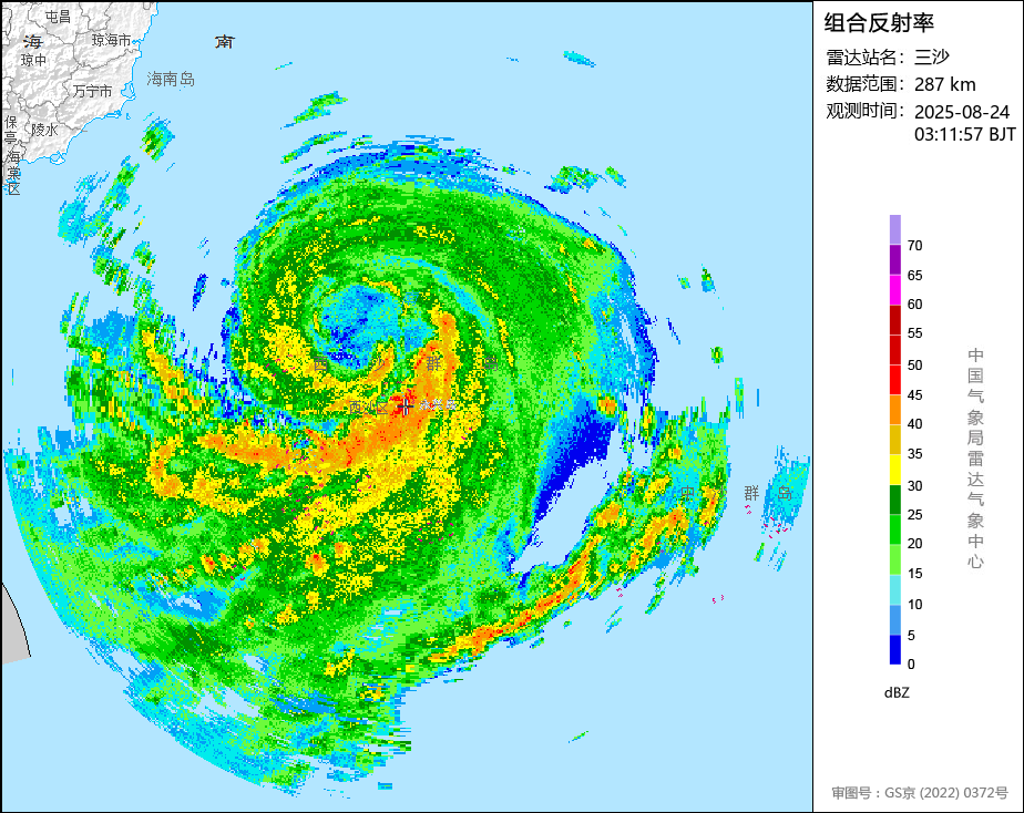
StormWeather wrote:Mods please update this to Kajiki

WTPQ51 RJTD 230000
RSMC TROPICAL CYCLONE ADVISORY
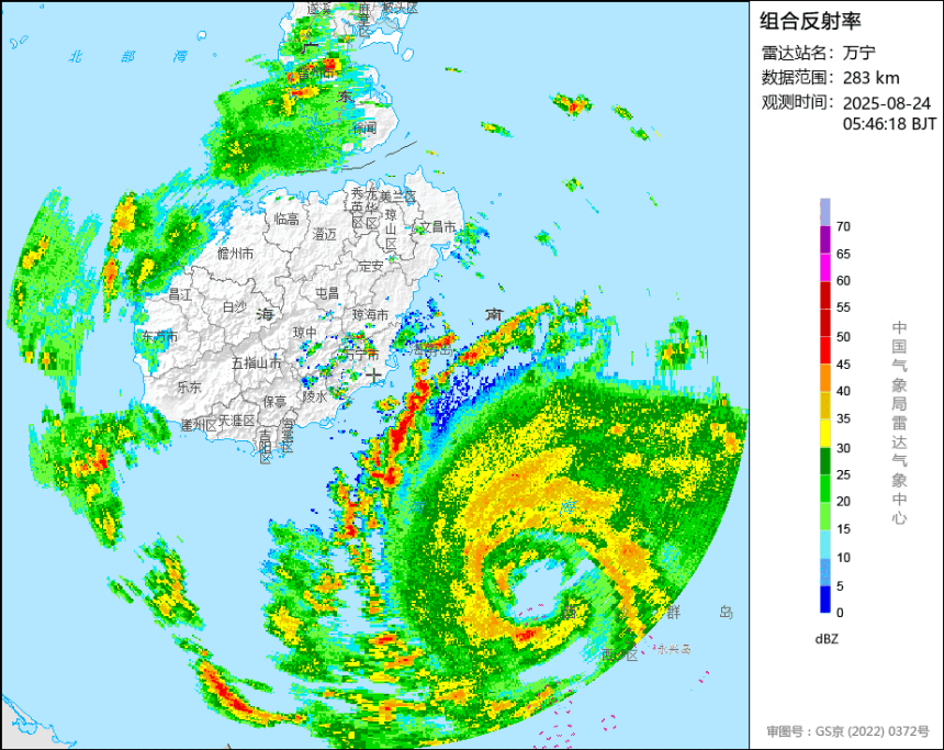
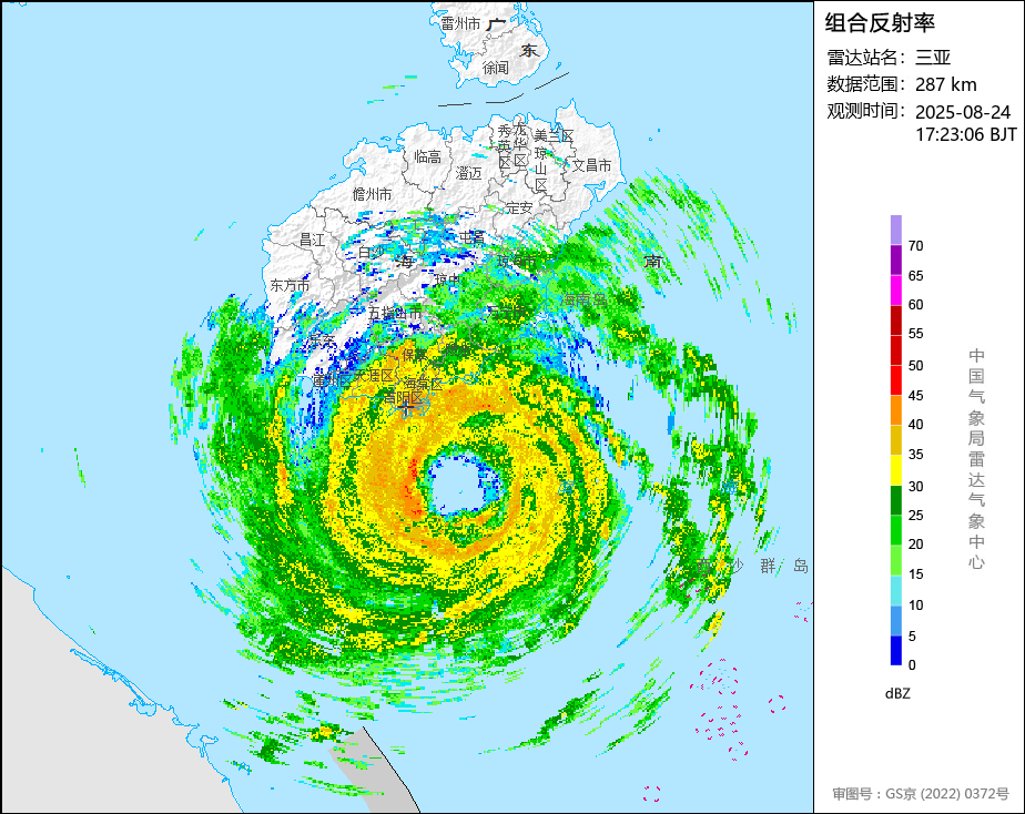
NAME TS 2513 KAJIKI (2513) UPGRADED FROM TD
ANALYSIS
PSTN 230000UTC 17.6N 116.4E FAIR
MOVE W 15KT
PRES 998HPA
MXWD 035KT
GUST 050KT
30KT 120NM
FORECAST
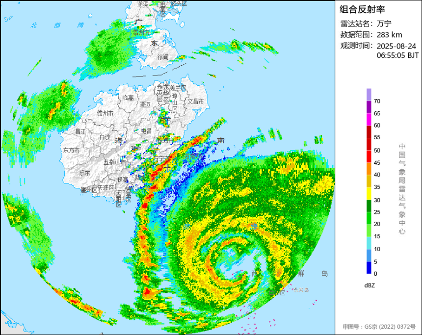
12HF 231200UTC 18.3N 114.2E 40NM 70%
MOVE WNW 11KT
PRES 996HPA
MXWD 040KT
GUST 060KT
24HF 240000UTC 18.3N 111.4E 57NM 70%
MOVE W 13KT
PRES 990HPA
MXWD 050KT
GUST 070KT
48HF 250000UTC 18.4N 107.5E 100NM 70%
MOVE W 09KT
PRES 965HPA
MXWD 070KT
GUST 100KT
72HF 260000UTC 19.1N 103.6E 140NM 70% TROPICAL DEPRESSION =


Also JTWC went with 40kts for 00z according to the ATCF.

Updated the title
1 likes   
ヤンデレ女が寝取られるているのを見たい!!!
ECMWF ensemble NWPAC plots: https://ecmwfensnwpac.imgbb.com/
Multimodel NWPAC plots: https://multimodelnwpac.imgbb.com/
GFS Ensemble NWPAC plots (16 & 35 day forecast): https://gefsnwpac.imgbb.com/
Plots updated automatically

User avatar
mrbagyo
Category 5
Category 5
Posts: 3765
Age: 33
Joined: Thu Apr 12, 2012 9:18 am
Location: 14.13N 120.98E
Contact:

Re: WPAC: KAJIKI - Tropical Storm

#22 Postby mrbagyo » Sat Aug 23, 2025 9:05 am

This thing is trying to form an eye based on Xisha's radar

Image

Image
3 likes   
The posts in this forum are NOT official forecast and should not be used as such. They are just the opinion of the poster and may or may not be backed by sound meteorological data. They are NOT endorsed by any professional institution or storm2k.org. For official information, please refer to RSMC, NHC and NWS products.

User avatar
mrbagyo
Category 5
Category 5
Posts: 3765
Age: 33
Joined: Thu Apr 12, 2012 9:18 am
Location: 14.13N 120.98E
Contact:

Re: WPAC: KAJIKI - Tropical Storm

#23 Postby mrbagyo » Sat Aug 23, 2025 11:30 am

Xisha @ 1500z

AAXX 23151 59981 04910 /2714 10266 20263 39953 49960 57047 61152 764// 333 10294 20256 3/025 5000/ 54415 59137 61041 71148 90720 91126

MSLP - 996 hPa
MSW - 50 kph
104mm over the past 6 hrs
2 likes   
The posts in this forum are NOT official forecast and should not be used as such. They are just the opinion of the poster and may or may not be backed by sound meteorological data. They are NOT endorsed by any professional institution or storm2k.org. For official information, please refer to RSMC, NHC and NWS products.

User avatar
Hurricane2022
Category 5
Category 5
Posts: 1673
Joined: Tue Aug 23, 2022 11:38 pm
Location: Araçatuba, Brazil

Re: WPAC: KAJIKI - Tropical Storm

#24 Postby Hurricane2022 » Sat Aug 23, 2025 5:27 pm

Holy cow!
 https://x.com/VortixWx/status/1959379765833720128


JMA says this is already a Typhoon. With this structure, I wouldn't rule out a HE C3/LE C4 peak before landfall in Vietnam.
0 likes   
Sorry for the bad English sometimes...!
For reliable and detailed information for any meteorological phenomenon, please consult the National Hurricane Center, Joint Typhoon Warning Center , or your local Meteo Center.

--------

Una cvm Christo, pro Christo, et in Christo. Sit nomen Domini benedictvm.

User avatar
mrbagyo
Category 5
Category 5
Posts: 3765
Age: 33
Joined: Thu Apr 12, 2012 9:18 am
Location: 14.13N 120.98E
Contact:

Re: WPAC: KAJIKI - Typhoon

#25 Postby mrbagyo » Sat Aug 23, 2025 6:12 pm

Last frame before Xisha radar stopped sending data
Image

Here are the latest radar frames from
Sanya
Image

Wanning
Image


Zhaoshu is a little bit more north of the radar site

Image
0 likes   
The posts in this forum are NOT official forecast and should not be used as such. They are just the opinion of the poster and may or may not be backed by sound meteorological data. They are NOT endorsed by any professional institution or storm2k.org. For official information, please refer to RSMC, NHC and NWS products.

User avatar
mrbagyo
Category 5
Category 5
Posts: 3765
Age: 33
Joined: Thu Apr 12, 2012 9:18 am
Location: 14.13N 120.98E
Contact:

Re: WPAC: KAJIKI - Typhoon

#26 Postby mrbagyo » Sat Aug 23, 2025 6:50 pm

Eye is starting to appear on visible light.
VHT are still rotating around it. RI is underway


Image

Image
2 likes   
The posts in this forum are NOT official forecast and should not be used as such. They are just the opinion of the poster and may or may not be backed by sound meteorological data. They are NOT endorsed by any professional institution or storm2k.org. For official information, please refer to RSMC, NHC and NWS products.

User avatar
cycloneye
Admin
Admin
Posts: 146756
Age: 69
Joined: Thu Oct 10, 2002 10:54 am
Location: San Juan, Puerto Rico

Re: WPAC: KAJIKI - Typhoon

#27 Postby cycloneye » Sat Aug 23, 2025 9:32 pm

Image
0 likes   
Visit the Caribbean-Central America Weather Thread where you can find at first post web cams,radars
and observations from Caribbean basin members Click Here

User avatar
mrbagyo
Category 5
Category 5
Posts: 3765
Age: 33
Joined: Thu Apr 12, 2012 9:18 am
Location: 14.13N 120.98E
Contact:

Re: WPAC: KAJIKI - Typhoon

#28 Postby mrbagyo » Sun Aug 24, 2025 4:28 am

It's moving NW over the last couple of frames - eyewall might clip Sanya
Image
0 likes   
The posts in this forum are NOT official forecast and should not be used as such. They are just the opinion of the poster and may or may not be backed by sound meteorological data. They are NOT endorsed by any professional institution or storm2k.org. For official information, please refer to RSMC, NHC and NWS products.

User avatar
StormWeather
Category 1
Category 1
Posts: 366
Joined: Wed Jun 05, 2024 2:34 pm

Re: WPAC: KAJIKI - Typhoon

#29 Postby StormWeather » Sun Aug 24, 2025 4:37 am

I had a feeling this would get much stronger than expected.
Last edited by StormWeather on Sun Aug 24, 2025 5:50 am, edited 1 time in total.
0 likes   
Just an average cyclone tracker

The posts in this forum are NOT official forecasts and should not be used as such. They are just the opinion of the poster and may or may not be backed by sound meteorological data. They are NOT endorsed by any professional institution or storm2k.org. For official information, please refer to the NHC and NWS products

User avatar
mrbagyo
Category 5
Category 5
Posts: 3765
Age: 33
Joined: Thu Apr 12, 2012 9:18 am
Location: 14.13N 120.98E
Contact:

Re: WPAC: KAJIKI - Typhoon

#30 Postby mrbagyo » Sun Aug 24, 2025 4:55 am

Image

Sanya now reporting typhoon strength gust
1 likes   
The posts in this forum are NOT official forecast and should not be used as such. They are just the opinion of the poster and may or may not be backed by sound meteorological data. They are NOT endorsed by any professional institution or storm2k.org. For official information, please refer to RSMC, NHC and NWS products.

User avatar
mrbagyo
Category 5
Category 5
Posts: 3765
Age: 33
Joined: Thu Apr 12, 2012 9:18 am
Location: 14.13N 120.98E
Contact:

Re: WPAC: KAJIKI - Typhoon

#31 Postby mrbagyo » Sun Aug 24, 2025 5:47 am

Image
0 likes   
The posts in this forum are NOT official forecast and should not be used as such. They are just the opinion of the poster and may or may not be backed by sound meteorological data. They are NOT endorsed by any professional institution or storm2k.org. For official information, please refer to RSMC, NHC and NWS products.

User avatar
eastcoastFL
Category 5
Category 5
Posts: 3936
Age: 43
Joined: Thu Apr 12, 2007 12:29 pm
Location: Palm City, FL

Re: WPAC: KAJIKI - Typhoon

#32 Postby eastcoastFL » Sun Aug 24, 2025 5:57 am

mrbagyo wrote:It's moving NW over the last couple of frames - eyewall might clip Sanya
https://s14.gifyu.com/images/bNBlp.gif


I wonder what the current intensity is. It looks a lot more organized in every frame
1 likes   
Personal Forecast Disclaimer:
The posts in this forum are NOT official forecast and should not be used as such. They are just the opinion of the poster and may or may not be backed by sound meteorological data. They are NOT endorsed by any professional institution or storm2k.org. For official information, please refer to the NHC and NWS products.

User avatar
mrbagyo
Category 5
Category 5
Posts: 3765
Age: 33
Joined: Thu Apr 12, 2012 9:18 am
Location: 14.13N 120.98E
Contact:

Re: WPAC: KAJIKI - Typhoon

#33 Postby mrbagyo » Sun Aug 24, 2025 6:01 am

Image
2 likes   
The posts in this forum are NOT official forecast and should not be used as such. They are just the opinion of the poster and may or may not be backed by sound meteorological data. They are NOT endorsed by any professional institution or storm2k.org. For official information, please refer to RSMC, NHC and NWS products.

User avatar
mrbagyo
Category 5
Category 5
Posts: 3765
Age: 33
Joined: Thu Apr 12, 2012 9:18 am
Location: 14.13N 120.98E
Contact:

Re: WPAC: KAJIKI - Typhoon

#34 Postby mrbagyo » Sun Aug 24, 2025 6:34 am

Image
0 likes   
The posts in this forum are NOT official forecast and should not be used as such. They are just the opinion of the poster and may or may not be backed by sound meteorological data. They are NOT endorsed by any professional institution or storm2k.org. For official information, please refer to RSMC, NHC and NWS products.

User avatar
mrbagyo
Category 5
Category 5
Posts: 3765
Age: 33
Joined: Thu Apr 12, 2012 9:18 am
Location: 14.13N 120.98E
Contact:

Re: WPAC: KAJIKI - Typhoon

#35 Postby mrbagyo » Sun Aug 24, 2025 7:37 am

Image

:uarrow: From TYboard forum
0 likes   
The posts in this forum are NOT official forecast and should not be used as such. They are just the opinion of the poster and may or may not be backed by sound meteorological data. They are NOT endorsed by any professional institution or storm2k.org. For official information, please refer to RSMC, NHC and NWS products.

Sciencerocks
Category 5
Category 5
Posts: 9409
Age: 39
Joined: Thu Jul 06, 2017 1:51 am

Re: WPAC: KAJIKI - Typhoon

#36 Postby Sciencerocks » Sun Aug 24, 2025 11:25 am

Image
0 likes   

User avatar
Ulf
Tropical Low
Tropical Low
Posts: 43
Joined: Sun Nov 03, 2024 9:32 pm

Re: WPAC: KAJIKI - Typhoon

#37 Postby Ulf » Sun Aug 24, 2025 4:16 pm

Structural deterioration from land interaction with Hainan might mean this will miss its chance at major and first very strong typhoon status of the season.

JTWC no longer forecasts any more strengthening due to less ocean heat content in the Gulf of Tonkin.
1 likes   

User avatar
cycloneye
Admin
Admin
Posts: 146756
Age: 69
Joined: Thu Oct 10, 2002 10:54 am
Location: San Juan, Puerto Rico

Re: WPAC: KAJIKI - Typhoon

#38 Postby cycloneye » Sun Aug 24, 2025 8:28 pm

Image
0 likes   
Visit the Caribbean-Central America Weather Thread where you can find at first post web cams,radars
and observations from Caribbean basin members Click Here


Return to “2025”

Who is online

Users browsing this forum: No registered users and 57 guests