
Exactly where I was thinking. Mid level shear isn't doing 94L any favors atm. Also, though not obvious on water vapor I'm thinking there's still some dry air for it to work out.
NATL: IMELDA - Post-Tropical - Discussion
Moderator: S2k Moderators
Re: NATL: INVEST 94L - Discussion (20/60)
Exactly where I was thinking. Mid level shear isn't doing 94L any favors atm. Also, though not obvious on water vapor I'm thinking there's still some dry air for it to work out.
0 likes
Andy D
(For official information, please refer to the NHC and NWS products.)
(For official information, please refer to the NHC and NWS products.)
-
cycloneye

- Admin

- Posts: 149703
- Age: 69
- Joined: Thu Oct 10, 2002 10:54 am
- Location: San Juan, Puerto Rico
Re: NATL: INVEST 94L - Discussion (30/70)
8 PM TWO:
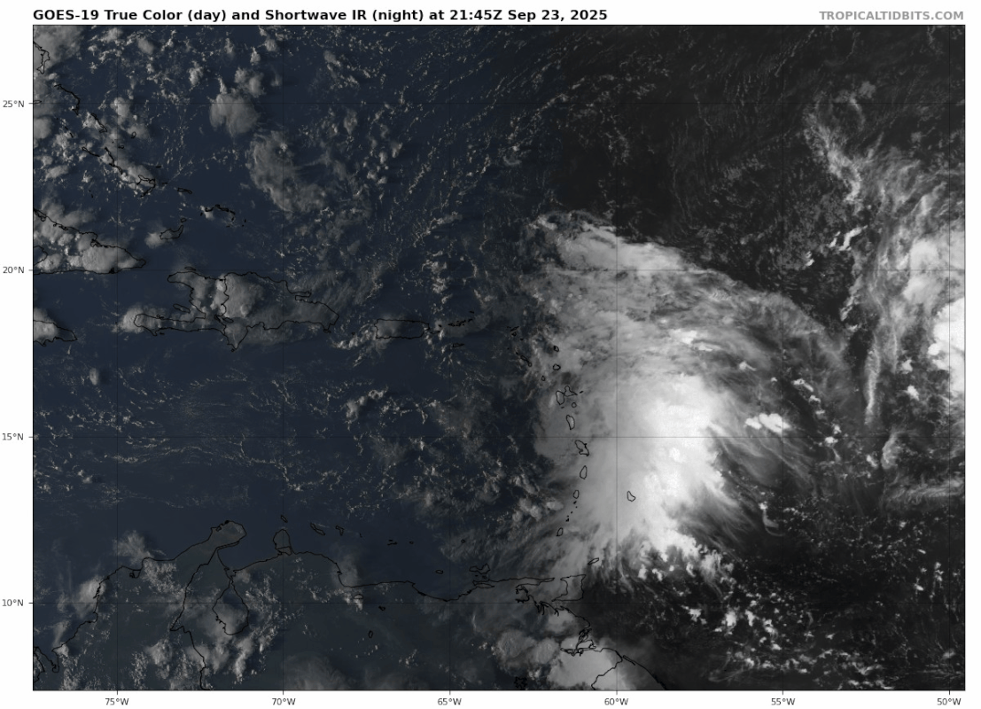
Eastern Caribbean Sea (AL94):
A tropical wave over the extreme northeastern Caribbean Sea
continues to produce a large area of disorganized showers,
thunderstorms and gusty winds across much of the Windward and
Leeward Islands. This wave is expected to move west-northwestward
at 15 to 20 mph, spreading heavy rainfall and gusty winds into
Puerto Rico and the Virgin Islands tonight and Wednesday, and across
the Dominican Republic beginning late Wednesday. The system is then
expected to slow down and turn northwestward when it reaches the
southwestern Atlantic in a couple of days. Environmental conditions
are forecast to be more conducive for development late this week,
and a tropical depression is likely to form when the disturbance is
in the vicinity of the Bahamas. Interests in the Virgin Islands,
Puerto Rico, the Dominican Republic, the Turks and Caicos Islands,
and the Bahamas should monitor the progress of this system.
* Formation chance through 48 hours...low...30 percent.
* Formation chance through 7 days...high...70 percent.
0 likes
Visit the Caribbean-Central America Weather Thread where you can find at first post web cams,radars
and observations from Caribbean basin members Click Here
and observations from Caribbean basin members Click Here
-
cycloneye
- Admin
- Posts: 149703
- Age: 69
- Joined: Thu Oct 10, 2002 10:54 am
- Location: San Juan, Puerto Rico
Re: NATL: INVEST 94L - Discussion (30/70)
00z Best Track:

AL, 94, 2025092400, , BEST, 0, 173N, 631W, 25, 1012, DB
0 likes
Visit the Caribbean-Central America Weather Thread where you can find at first post web cams,radars
and observations from Caribbean basin members Click Here
and observations from Caribbean basin members Click Here

Re: NATL: INVEST 94L - Discussion (30/70)
Interesting how the DeepMind ensembles have a significant number of members - some with serious depth - impacting the Bahamas and the US East Coast (particularly Georgia and the Carolinas), while the Euro is lukewarm on the idea, and the GFS consensus is against CONUS impacts altogether. Quite a spread of possible solutions, but the timeframe is still "6-7 days out". In 48 hours or so we might see more agreement one way or another; for now, the disturbance appears less organised than 93L & not especially close to TCG, which is bound to make forecasting more difficult.
2 likes
-
OuterBanker
- S2K Supporter

- Posts: 1761
- Joined: Wed Feb 26, 2003 10:53 am
- Location: Nags Head, NC
- Contact:
Re: NATL: INVEST 94L - Discussion (30/70)
Quite possibly some of the most bizarre scenarios I’ve ever seen.
Just when I thought this season was really boring.
Can’t wait to see this all pan out.
(as long as it doesn’t affect us)
Just when I thought this season was really boring.
Can’t wait to see this all pan out.
(as long as it doesn’t affect us)
6 likes
-
wzrgirl1

- S2K Supporter
- Posts: 1360
- Joined: Sat Sep 04, 2004 6:44 am
- Location: Pembroke Pines, Florida
Re: NATL: INVEST 94L - Discussion (30/70)
We have quite an interesting set up upon us and nobody’s talking about it?
1 likes
Re: NATL: INVEST 94L - Discussion (30/70)
If these two behave as the models are suggesting, I would advocate for putting both 93 and 94L into the same discussion and model forums.
0 likes

Re: NATL: INVEST 94L - Discussion (30/70)
This actually seems surprisingly decent for 94L, especially after days of being blasted by Gabrielle's outflow, too close to 93L, and unenthusiastic models. Perhaps this organization is what convinced the recent model runs?
1 likes
TC naming lists: retirements and intensity
Most aggressive Advisory #1's in North Atlantic (cr. kevin for starting the list)
Most aggressive Advisory #1's in North Atlantic (cr. kevin for starting the list)
-
HurricaneBelle

- S2K Supporter
- Posts: 1209
- Joined: Sun Aug 27, 2006 6:12 pm
- Location: Clearwater, FL
Re: NATL: INVEST 94L - Discussion (30/70)
Seems like it's been quite a while since we had a storm take a crazy track - Eta is the last one I remember, although I'm sure someone will chime in with one more recent. Typically they're late October or November storms (Gordon 1994 takes the cake).
2 likes
Re: NATL: INVEST 94L - Discussion (30/70)
Just as an aside....... both 93L & 94L kinda look like crap right now 
0 likes
Andy D
(For official information, please refer to the NHC and NWS products.)
(For official information, please refer to the NHC and NWS products.)
-
AutoPenalti
- Category 5

- Posts: 4091
- Age: 29
- Joined: Mon Aug 17, 2015 4:16 pm
- Location: Ft. Lauderdale, Florida
Re: NATL: INVEST 94L - Discussion (30/70)
I take it the NHC don’t seem to believe the AI ensemble models that are closer to FL?
0 likes
The posts in this forum are NOT official forecasts and should not be used as such. They are just the opinion of the poster and may or may not be backed by sound meteorological data. They are NOT endorsed by any professional institution or STORM2K. For official information, please refer to products from the NHC and NWS.
Model Runs Cheat Sheet:
GFS (5:30 AM/PM, 11:30 AM/PM)
HWRF, GFDL, UKMET, NAVGEM (6:30-8:00 AM/PM, 12:30-2:00 AM/PM)
ECMWF (1:45 AM/PM)
TCVN is a weighted averaged
-
cycloneye
- Admin
- Posts: 149703
- Age: 69
- Joined: Thu Oct 10, 2002 10:54 am
- Location: San Juan, Puerto Rico
Re: NATL: INVEST 94L - Discussion (30/80)
2 AM TWO:
Eastern Caribbean Sea (AL94):
A tropical wave over the northeastern Caribbean Sea continues to
produce a large area of disorganized showers, thunderstorms and
gusty winds across much of the Windward and Leeward Islands. This
wave is expected to move west-northwestward at 15 to 20 mph,
spreading heavy rainfall and gusty winds into Puerto Rico and the
Virgin Islands today, and across the Dominican Republic beginning
tonight. The system is then expected to slow down and turn
northwestward when it reaches the southwestern Atlantic in a couple
of days. Environmental conditions are forecast to be more conducive
for development late this week and weekend, and a tropical
depression is likely to form when the disturbance is in the vicinity
of the Bahamas. Interests in the Virgin Islands, Puerto Rico, the
Dominican Republic, the Turks and Caicos Islands, and the Bahamas
should monitor the progress of this system.
* Formation chance through 48 hours...low...30 percent.
* Formation chance through 7 days...high...80 percent.
0 likes
Visit the Caribbean-Central America Weather Thread where you can find at first post web cams,radars
and observations from Caribbean basin members Click Here
and observations from Caribbean basin members Click Here
-
Blown Away

- S2K Supporter
- Posts: 10253
- Joined: Wed May 26, 2004 6:17 am
Re: NATL: INVEST 94L - Discussion (30/80)
I'm calling it, naked swirl landfall in Puerto Rico!
2 likes
Hurricane Eye Experience: David 79, Irene 99, Frances 04, Jeanne 04, Wilma 05… Hurricane Brush Experience: Andrew 92, Erin 95, Floyd 99, Matthew 16, Irma 17, Ian 22, Nicole 22…
-
skillz305
- Category 1

- Posts: 312
- Joined: Sat Sep 08, 2018 11:10 am
- Location: Miami, Florida --> Vero Beach, Florida
Re: NATL: INVEST 94L - Discussion (30/80)
94L please stay away from Florida….
0 likes
 Hurricanes: Andrew 1992 - Irene 1999 - Frances 2004 - Jeanne 2004 - Katrina 2005 - Wilma 2005 - Matthew 2016 - Irma 2017 - Ian 2022 - Nicole 2022 - Milton 2024
Re: NATL: INVEST 94L - Discussion (30/80)
skillz305 wrote:94L please stay away from Florida….
An ULL is supposed to drop into the NE Gulf and shield Florida from 94L and turn it North towards the Carolinas.
1 likes
-
cycloneye
- Admin
- Posts: 149703
- Age: 69
- Joined: Thu Oct 10, 2002 10:54 am
- Location: San Juan, Puerto Rico
Re: NATL: INVEST 94L - Discussion (30/80)
Eastern Caribbean Sea (AL94):
A tropical wave over the northeastern Caribbean Sea is producing
disorganized showers and thunderstorms. This wave is expected to
move west-northwestward at 15 to 20 mph, spreading heavy rainfall
and gusty winds into Puerto Rico and the Virgin Islands today, and
across the Dominican Republic beginning tonight. The system is then
expected to slow down and turn northwestward when it reaches the
southwestern Atlantic late this week. Environmental conditions are
forecast to be more conducive for development in a few days, and a
tropical depression is likely to form when the disturbance is in the
vicinity of the Bahamas. Interests in the Virgin Islands, Puerto
Rico, the Dominican Republic, the Turks and Caicos Islands, and the
Bahamas should monitor the progress of this system. An Air Force
Hurricane Hunter Aircraft is scheduled to perform a system survey
this afternoon to gather data from the surrounding environment, if
necessary.
* Formation chance through 48 hours...low...30 percent.
* Formation chance through 7 days...high...80 percent.
0 likes
Visit the Caribbean-Central America Weather Thread where you can find at first post web cams,radars
and observations from Caribbean basin members Click Here
and observations from Caribbean basin members Click Here
-
cycloneye
- Admin
- Posts: 149703
- Age: 69
- Joined: Thu Oct 10, 2002 10:54 am
- Location: San Juan, Puerto Rico
Re: NATL: INVEST 94L - Discussion (30/80)
12z Best Track:

AL, 94, 2025092412, , BEST, 0, 176N, 650W, 25, 1012, DB
0 likes
Visit the Caribbean-Central America Weather Thread where you can find at first post web cams,radars
and observations from Caribbean basin members Click Here
and observations from Caribbean basin members Click Here
-
ScottNAtlanta

- Category 5
- Posts: 2535
- Joined: Sat May 25, 2013 3:11 pm
- Location: Atlanta, GA
Re: NATL: INVEST 94L - Discussion (30/80)
I've noticed that vorticity has increased and become more circular today. It will be slow to develop, but I believe it will eventually.
2 likes
The posts in this forum are NOT official forecast and should not be used as such. They are just the opinion of the poster and may or may not be backed by sound meteorological data. They are NOT endorsed by any professional institution or storm2k.org. For official information, please refer to the NHC and NWS products.
Re: NATL: INVEST 94L - Discussion (30/80)
Boy, the upper level winds are ripping! Given it's overall appearance, upper level conditions, near term land interaction, and GFS suggesting that 94L will become absorbed by 93L.... I'd reconsider the odds for development to be "a generous" 10/50.
0 likes
Andy D
(For official information, please refer to the NHC and NWS products.)
(For official information, please refer to the NHC and NWS products.)
Who is online
Users browsing this forum: No registered users and 74 guests