NATL: HUMBERTO - Remnants - Discussion
Moderator: S2k Moderators
-
Hurricane Mike
- Category 2

- Posts: 675
- Joined: Tue Apr 10, 2018 7:44 am
Re: NATL: HUMBERTO - Hurricane - Discussion
I disagree with the forecast to Category 5. I don't think Humberto will reach it. I could be wrong but I think it stays as a Category 4.
0 likes


-
cheezyWXguy

- Category 5

- Posts: 6282
- Joined: Mon Feb 13, 2006 12:29 am
- Location: Dallas, TX
Re: NATL: HUMBERTO - Hurricane - Discussion
Zonacane wrote:Looks like an ERC is underway
Although I had my suspicions earlier about this, I don’t think that’s what we’re seeing here. Switch over to nighttime visible and you can see that the eye is still stable, but it’s become partially clouded for the time being, as has been the case a couple of times today. Tomorrow it may be a different story, but for now I’d expect the eye to clear out again with time.
0 likes

Re: NATL: HUMBERTO - Hurricane - Discussion
Interesting discussion in the TAFB 06z subjective dvorak fix, they say weakness in the western eyewall is from shear from the outflow of PTC 9:
TXNT23 KNES 270616
TCSNTL
A. 08L (HUMBERTO)
B. 27/0600Z
C. 22.3N
D. 58.9W
E. ONE/GOES-E
F. T6.0/6.0
G. IR/EIR/PRXY/MHS
H. REMARKS...WMG EYE SURROUNDED BY W AND EMBEDDED IN LG RESULTS IN AN E#
OF 5.0 WITH +1.0 EADJ FOR A DT OF 6.0. EYE TEMP +12 C. SOME EROSION OF
WRN EYEWALL LAST 6 HR DUE TO W SHEAR FM OUTFLOW FM PTC 9. MET=5.0 AND
PT=5.5. FT BASED ON DT.
I. ADDL POSITIONS
27/0047Z 22.1N 58.5W MHS
...KONON
1 likes
-
MEANINGLESS_NUMBERS
- Category 2
- Posts: 503
- Joined: Mon Nov 02, 2020 1:43 pm
Re: NATL: HUMBERTO - Hurricane - Discussion
Travorum wrote:Interesting discussion in the TAFB 06z subjective dvorak fix, they say weakness in the western eyewall is from shear from the outflow of PTC 9:TXNT23 KNES 270616
TCSNTL
A. 08L (HUMBERTO)
B. 27/0600Z
C. 22.3N
D. 58.9W
E. ONE/GOES-E
F. T6.0/6.0
G. IR/EIR/PRXY/MHS
H. REMARKS...WMG EYE SURROUNDED BY W AND EMBEDDED IN LG RESULTS IN AN E#
OF 5.0 WITH +1.0 EADJ FOR A DT OF 6.0. EYE TEMP +12 C. SOME EROSION OF
WRN EYEWALL LAST 6 HR DUE TO W SHEAR FM OUTFLOW FM PTC 9. MET=5.0 AND
PT=5.5. FT BASED ON DT.
I. ADDL POSITIONS
27/0047Z 22.1N 58.5W MHS
...KONON
Good. Let them fight each other!
1 likes
Emily '87, Felix '95, Gert '99, Fabian '03, Humberto '19, Paulette '20, Teddy '20, Fiona '22, Lee '23, Ernesto '24, Humberto/Imelda '25


-
Hypercane_Kyle

- Category 5
- Posts: 3465
- Joined: Sat Mar 07, 2015 7:58 pm
- Location: Cape Canaveral, FL
Re: NATL: HUMBERTO - Hurricane - Discussion
Looking fierce this morning. Looks somewhat similar to Beryl last year.

5 likes
My posts are my own personal opinion, defer to the National Hurricane Center (NHC) and other NOAA products for decision making during hurricane season.
Re: NATL: HUMBERTO - Hurricane - Discussion
12z best track:
AL, 08, 2025092712, , BEST, 0, 225N, 597W, 125, 938, HU
0 likes

Re: NATL: HUMBERTO - Hurricane - Discussion
Travorum wrote:12z best track:AL, 08, 2025092712, , BEST, 0, 225N, 597W, 125, 938, HU
I'm a little surprised they didn't go higher than the 9z advisory. It still seems to be intensifying to me with the eye clearing out further.
5 likes
TC naming lists: retirements and intensity
Most aggressive Advisory #1's in North Atlantic (cr. kevin for starting the list)
Most aggressive Advisory #1's in North Atlantic (cr. kevin for starting the list)
-
cycloneye

- Admin

- Posts: 149688
- Age: 69
- Joined: Thu Oct 10, 2002 10:54 am
- Location: San Juan, Puerto Rico
Re: NATL: HUMBERTO - Hurricane - Discussion
Travorum wrote:12z best track:AL, 08, 2025092712, , BEST, 0, 225N, 597W, 125, 938, HU
The satellite presentation has improved bigtime and IMO, is stronger that 125kt.
1 likes
Visit the Caribbean-Central America Weather Thread where you can find at first post web cams,radars
and observations from Caribbean basin members Click Here
and observations from Caribbean basin members Click Here
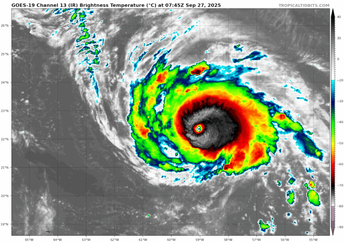
Re: NATL: HUMBERTO - Hurricane - Discussion
Teban54 wrote:Travorum wrote:12z best track:AL, 08, 2025092712, , BEST, 0, 225N, 597W, 125, 938, HU
I'm a little surprised they didn't go higher than the 9z advisory. It still seems to be intensifying to me with the eye clearing out further.
https://i.postimg.cc/Fs8ZYdM2/goes19-ir-08-L-202509270745.gif
It definitely looks stronger than 125kts but subjective dvorak bulletins came in at 6.0 and 6.5 (the B ring was just on the edge of being thick enough) and ADT CI# was down due to the weaker appearance overnight, so I imagine they split the difference and kept it constant. I think we'll see 130+ at 11am if trends continue.
2 likes
Re: NATL: HUMBERTO - Hurricane - Discussion
As a fun side note, the probable reason there's no meso sector over Humberto (at least yesterday, not sure about today) is a cascading situation that goes all the way over to Hawaii. Kauai radar was offline requiring a GOES-18 meso sector over it for forecasted weather. An extratropical low in Alaska took up the other GOES-18 meso. Excessive rainfall in Arizona required a meso sector that normally would be from GOES-18, but because Hawaii needs one as radar is down a GOES-19 sector was allocated instead. The second GOES-19 sector was allocated to PTC 9 and South Carolina. So if radar in Kauai didn't go down we may have had a meso sector over Humberto.
2 likes
-
Sciencerocks
- Category 5
- Posts: 10189
- Age: 40
- Joined: Thu Jul 06, 2017 1:51 am

Re: NATL: HUMBERTO - Hurricane - Discussion
Sciencerocks wrote:https://imagizer.imageshack.com/img923/2084/et3NZ4.gif
that's a lot of lightning in the W eyewall.
0 likes

Re: NATL: HUMBERTO - Hurricane - Discussion
Looking beastly compared to last night, the CDO has thickened a lot on the west side. The slight shear must have relaxed. Could be making a run for cat 5 now.
0 likes
Igor 2010, Sandy 2012, Fay 2014, Gonzalo 2014, Joaquin 2015, Nicole 2016, Humberto 2019, Imelda 2025
I am only a tropical weather enthusiast. My predictions are not official and may or may not be backed by sound meteorological data. For official information, please refer to the NHC and NWS products.
I am only a tropical weather enthusiast. My predictions are not official and may or may not be backed by sound meteorological data. For official information, please refer to the NHC and NWS products.
-
Hurricane2022

- Category 5
- Posts: 2090
- Joined: Tue Aug 23, 2022 11:38 pm
- Location: Araçatuba, Brazil
Re: NATL: HUMBERTO - Hurricane - Discussion
0 likes
Sorry for the bad English sometimes...!
For reliable and detailed information for any meteorological phenomenon, please consult the National Hurricane Center, Joint Typhoon Warning Center , or your local Meteo Center.
--------
ECCE OMNIA NOVA FACIAM (Ap 21,5).
For reliable and detailed information for any meteorological phenomenon, please consult the National Hurricane Center, Joint Typhoon Warning Center , or your local Meteo Center.
--------
ECCE OMNIA NOVA FACIAM (Ap 21,5).

Re: NATL: HUMBERTO - Hurricane - Discussion
Looks like I was wrong about that ERC last night, Humberto certainly looks like a category 5 this morning. Humberto reminds me a lot of the way Dorian looked.
2 likes

Re: NATL: HUMBERTO - Hurricane - Discussion
Man, I wish we had recon in this storm. I understand 9/future Imelda takes priority, but still. I’m convinced this storm is making a run at category 5 and I’m sure I speak for all of us when I say I’d love to see what some center passes would find…
3 likes
Who is online
Users browsing this forum: No registered users and 89 guests