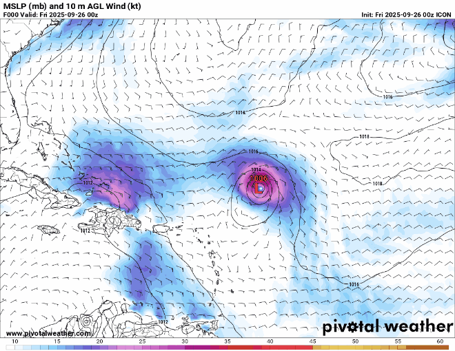
NATL: IMELDA - Models

Moderator: S2k Moderators

Message
Author
User avatar
Category5Kaiju
Category 5
Category 5
Posts: 4233
Joined: Thu Dec 24, 2020 12:45 pm
Location: Seattle

Re: NATL: INVEST 94L - Models

#201 Postby Category5Kaiju » Thu Sep 25, 2025 11:02 pm

AnnularCane wrote:


Saw the mainland and immediately chickened out. :lol:


Haha, I'm going to head towards the CONUS and then...oh wait, shoot, is that SOUTH CAROLINA? Nope, bye-bye.

That run literally has this system acting like a sentient being lol. Also, in all seriousness, that almost due southeast track in that particular location is something else, usually storms there head west, northwest, north, or northeast.
4 likes   
Unless explicitly stated, all info in my posts is based on my own opinions and observations. Tropical storms and hurricanes can be extremely dangerous. Do not think you can beat Mother Nature. Refer to an accredited weather research agency or meteorologist if you need to make serious decisions regarding an approaching storm.

BobHarlem
Category 5
Category 5
Posts: 2535
Joined: Thu Oct 20, 2005 6:11 pm

Re: NATL: INVEST 94L - Models

#202 Postby BobHarlem » Thu Sep 25, 2025 11:05 pm

0z gfs landfall myrtle beach, same place as 18z, just slightly stronger this run.
Image
Image
1 likes   

LarryWx
S2K Supporter
S2K Supporter
Posts: 6830
Joined: Sun Sep 07, 2003 2:04 pm
Location: GA

Re: NATL: INVEST 94L - Models

#203 Postby LarryWx » Fri Sep 26, 2025 12:12 am

0Z: So far, similar to 12Z with GFS hitting Myrtle Beach while Icon, CMC, and UKMET again all Fujiwara 94L safely OTS

JMA only goes out to 72 at 0Z…so, can’t tell much

Euro is next

—————-

0Z UKMET:

NEW TROPICAL CYCLONE FORECAST TO DEVELOP AFTER 48 HOURS
FORECAST POSITION AT T+ 48 : 22.5N 76.7W

LEAD CENTRAL MAXIMUM WIND
VERIFYING TIME TIME POSITION PRESSURE (MB) SPEED (KNOTS)
-------------- ---- -------- ------------- -------------
0000UTC 28.09.2025 48 22.5N 76.7W 1004 39
1200UTC 28.09.2025 60 24.8N 76.1W 1003 41
0000UTC 29.09.2025 72 25.6N 76.6W 1000 42
1200UTC 29.09.2025 84 26.5N 77.1W 999 40
0000UTC 30.09.2025 96 27.3N 77.3W 997 43
1200UTC 30.09.2025 108 27.3N 77.3W 995 43
0000UTC 01.10.2025 120 27.1N 75.4W 992 44
1200UTC 01.10.2025 132 27.3N 73.5W 989 44
0000UTC 02.10.2025 144 28.8N 70.0W 984 52
1200UTC 02.10.2025 156 30.8N 65.1W 979 69
0000UTC 03.10.2025 168 34.6N 57.8W 972 76
0 likes   
Personal Forecast Disclaimer:
The posts in this forum are NOT official forecasts and should not be used as such. They are just the opinion of the poster and may or may not be backed by sound meteorological data. They are NOT endorsed by any professional institution or storm2k.org. For official information, please refer to the NHC and NWS products.

User avatar
chaser1
S2K Supporter
S2K Supporter
Posts: 5718
Age: 64
Joined: Sat Oct 15, 2005 5:59 pm
Location: Longwood, Fl

Re: NATL: INVEST 94L - Models

#204 Postby chaser1 » Fri Sep 26, 2025 12:34 am


ICON be like -
The food coming out of the new Steak burger Food Truck smells amazing, until we see 3 cockroaches sitting directly on the order window menu! NOPE, WE'RE OUT :ggreen:
0 likes   
Andy D

(For official information, please refer to the NHC and NWS products.)

LarryWx
S2K Supporter
S2K Supporter
Posts: 6830
Joined: Sun Sep 07, 2003 2:04 pm
Location: GA

Re: NATL: INVEST 94L - Models

#205 Postby LarryWx » Fri Sep 26, 2025 12:40 am

0Z Euro much different vs prior Euros
0 likes   
Personal Forecast Disclaimer:
The posts in this forum are NOT official forecasts and should not be used as such. They are just the opinion of the poster and may or may not be backed by sound meteorological data. They are NOT endorsed by any professional institution or storm2k.org. For official information, please refer to the NHC and NWS products.

Stratton23
Category 5
Category 5
Posts: 2827
Joined: Fri Jul 21, 2023 10:59 pm
Location: Katy, Tx

Re: NATL: INVEST 94L - Models

#206 Postby Stratton23 » Fri Sep 26, 2025 12:45 am

Euro stalls out 94L inland, potential big time rain makwr in the carolinas
0 likes   

LarryWx
S2K Supporter
S2K Supporter
Posts: 6830
Joined: Sun Sep 07, 2003 2:04 pm
Location: GA

Re: NATL: INVEST 94L - Models

#207 Postby LarryWx » Fri Sep 26, 2025 12:48 am

0Z Euro stalls for 48 hours just offshore SC/GA before turning back WNW into Beaufort, SC and not til Thu night!
0 likes   
Personal Forecast Disclaimer:
The posts in this forum are NOT official forecasts and should not be used as such. They are just the opinion of the poster and may or may not be backed by sound meteorological data. They are NOT endorsed by any professional institution or storm2k.org. For official information, please refer to the NHC and NWS products.

User avatar
chaser1
S2K Supporter
S2K Supporter
Posts: 5718
Age: 64
Joined: Sat Oct 15, 2005 5:59 pm
Location: Longwood, Fl

Re: NATL: INVEST 94L - Models

#208 Postby chaser1 » Fri Sep 26, 2025 12:51 am

If NAM is the very worse model for tropical cyclone forecast accuracy, then tossing in a binary tropical twin into the mix can only be that much more fun to consider. Actually, 0Z NAM seems pretty on point. Delayed development until a weak TD forms just S.E. of Andros. Then, slowly strengthens and slowly crawls NNE to just east of Grand Bahama. Meanwhile, Humberto is closing the gap and deepening, and then passing north of 91L's latitude and shouts "Hold my beer"
0 likes   
Andy D

(For official information, please refer to the NHC and NWS products.)

LarryWx
S2K Supporter
S2K Supporter
Posts: 6830
Joined: Sun Sep 07, 2003 2:04 pm
Location: GA

Re: NATL: INVEST 94L - Models

#209 Postby LarryWx » Fri Sep 26, 2025 1:13 am

0Z GEFS: 14 of 30 members with SE US landfall with one of those 14 a hurricane
0 likes   
Personal Forecast Disclaimer:
The posts in this forum are NOT official forecasts and should not be used as such. They are just the opinion of the poster and may or may not be backed by sound meteorological data. They are NOT endorsed by any professional institution or storm2k.org. For official information, please refer to the NHC and NWS products.

LarryWx
S2K Supporter
S2K Supporter
Posts: 6830
Joined: Sun Sep 07, 2003 2:04 pm
Location: GA

Re: NATL: INVEST 94L - Models

#210 Postby LarryWx » Fri Sep 26, 2025 1:38 am

0Z EPS: 29 of 50 hit SE US with ~10-11 as hurricanes
0 likes   
Personal Forecast Disclaimer:
The posts in this forum are NOT official forecasts and should not be used as such. They are just the opinion of the poster and may or may not be backed by sound meteorological data. They are NOT endorsed by any professional institution or storm2k.org. For official information, please refer to the NHC and NWS products.

User avatar
chaser1
S2K Supporter
S2K Supporter
Posts: 5718
Age: 64
Joined: Sat Oct 15, 2005 5:59 pm
Location: Longwood, Fl

Re: NATL: INVEST 94L - Models

#211 Postby chaser1 » Fri Sep 26, 2025 3:01 am

Larry, you ever notice a EURO run that does what tonight's 0Z does LOL??
Approaches S. Carolina coast but then stops and moves southeast.... just to turn right around and steamroll back to the northwest and make landfall :lol:
0 likes   
Andy D

(For official information, please refer to the NHC and NWS products.)

skillz305
Category 1
Category 1
Posts: 311
Joined: Sat Sep 08, 2018 11:10 am
Location: Miami, Florida --> Vero Beach, Florida

Re: NATL: INVEST 94L - Models

#212 Postby skillz305 » Fri Sep 26, 2025 4:20 am

Image
0 likes   
:flag:Hurricanes: Andrew 1992 - Irene 1999 - Frances 2004 - Jeanne 2004 - Katrina 2005 - Wilma 2005 - Matthew 2016 - Irma 2017 - Ian 2022 - Nicole 2022 - Milton 2024

User avatar
kevin
Category 5
Category 5
Posts: 2795
Age: 27
Joined: Wed Aug 28, 2019 4:35 am

Re: NATL: INVEST 94L - Models

#213 Postby kevin » Fri Sep 26, 2025 4:23 am

06z ICON still shows 94L being dragged behind Humberto, most likely OTS. Ends the run at +120hr as a strengthening 960mb hurricane.
0 likes   

BobHarlem
Category 5
Category 5
Posts: 2535
Joined: Thu Oct 20, 2005 6:11 pm

Re: NATL: INVEST 94L - Models

#214 Postby BobHarlem » Fri Sep 26, 2025 5:20 am

6z gfs
Image
0 likes   

User avatar
Kohlecane
Category 2
Category 2
Posts: 600
Age: 34
Joined: Sun Jul 31, 2011 11:03 pm
Location: Beaufort, SC

Re: NATL: INVEST 94L - Models

#215 Postby Kohlecane » Fri Sep 26, 2025 5:37 am

LarryWx wrote:0Z Euro stalls for 48 hours just offshore SC/GA before turning back WNW into Beaufort, SC and not til Thu night!

Oh wonderful :roll:
1 likes   
Once I see the REDS and GREENS Converge on a Base Velocity. ... I'm There!!

This is NOT an Official Forecast....Just my Opinion. For official information, please refer to the NHC and NWS products.
HIGHLIGHTS : '13 El Reno Tornado : 2013 Storm Chaser Tour, Joaquin; SC flood event, Matthew '16, Lowcountry Snow storm Jan '18

BobHarlem
Category 5
Category 5
Posts: 2535
Joined: Thu Oct 20, 2005 6:11 pm

Re: NATL: INVEST 94L - Models

#216 Postby BobHarlem » Fri Sep 26, 2025 5:43 am

ensembles
0z euro ensembles:
Image

deep mind:
Image
0 likes   

TampaWxLurker
Tropical Storm
Tropical Storm
Posts: 195
Joined: Thu Aug 01, 2024 8:20 am

Re: NATL: INVEST 94L - Models

#217 Postby TampaWxLurker » Fri Sep 26, 2025 6:10 am

Literal fork in the road on models, still.

I really don't begrudge NHC on how they display the track when this gets tagged as a PTC/named.
2 likes   

User avatar
cycloneye
Admin
Admin
Posts: 148043
Age: 69
Joined: Thu Oct 10, 2002 10:54 am
Location: San Juan, Puerto Rico

Re: NATL: INVEST 94L - Models

#218 Postby cycloneye » Fri Sep 26, 2025 6:41 am

Cat 2 on HAFS-B as it approaches the Carolinas coast.

Image
2 likes   
Visit the Caribbean-Central America Weather Thread where you can find at first post web cams,radars
and observations from Caribbean basin members Click Here

User avatar
Blown Away
S2K Supporter
S2K Supporter
Posts: 10225
Joined: Wed May 26, 2004 6:17 am

Re: NATL: INVEST 94L - Models

#219 Postby Blown Away » Fri Sep 26, 2025 7:13 am

Image
Guidance continues wanting 94L to immediately begin moving NW and position keeps adjusting west. Moving into E Cuba or just S of E Cuba is possible.
1 likes   
Hurricane Eye Experience: David 79, Irene 99, Frances 04, Jeanne 04, Wilma 05… Hurricane Brush Experience: Andrew 92, Erin 95, Floyd 99, Matthew 16, Irma 17, Ian 22, Nicole 22…

User avatar
Travorum
Category 2
Category 2
Posts: 547
Joined: Tue Sep 05, 2023 9:36 am
Location: Dunedin, FL

Re: NATL: INVEST 94L - Models

#220 Postby Travorum » Fri Sep 26, 2025 7:20 am

Looking only at the operational models, it seems with the recent trends GFS is just about alone when it comes to showing a clean landfall. Icon, CMC, UKMET, and Euro-AI all show binary interaction pulling 94L away from the coast before landfall, and the Euro shows a stall off the coast before moving in. This largely comes down to forward speed, with the GFS showing a slightly faster 94L being pulled north by a stronger trough. As for the ensembles its pretty evenly split between landfall, stall, and being pulled behind Humberto, with Euro and GFS ensembles showing a greater preference for a landfall scenario, while CMC and AI ensembles are split between a stall and OTS scenario.

So long story short, we're about three and a half days out from a potential US landfall and not even sure its going to happen.
2 likes   


Return to “2025”

Who is online

Users browsing this forum: No registered users and 58 guests