NATL: IMELDA - Models

Moderator: S2k Moderators

Message
Author
BobHarlem
Category 5
Category 5
Posts: 2535
Joined: Thu Oct 20, 2005 6:11 pm

Re: NATL: INVEST 94L - Models

#221 Postby BobHarlem » Fri Sep 26, 2025 7:30 am

6z hurricane models all somewhere in the cat 2 range
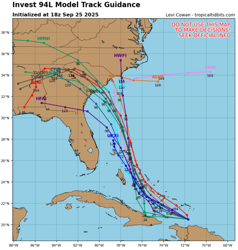
6z HWRF landfall near Myrtle Beach (Then goes into w nc)
Image
6z HMON landfall near Georgetown (also stalls around nc/tn border)
Image
6z HAFS-a landfall near Hilton Head
Image
6z HAFS-b landfall near Charleston
Image
1 likes   

User avatar
ronjon
Category 5
Category 5
Posts: 4881
Joined: Fri Aug 19, 2005 5:17 pm
Location: Hernando Beach, FL

Re: NATL: INVEST 94L - Models

#222 Postby ronjon » Fri Sep 26, 2025 7:36 am

The 06Z hurricane models are trending slightly faster and stronger. HWRF shifted 50 miles west w landfall near Myrtle Beach SC near 5 pm Monday and now 969 mb. HMON near Charleston SC at 2 pm Monday at 983 mb. HAFS-A just north of Savannah GA at 1am Tuesday at 983 mb and HAFS-B just north of Savannah near midnight Tuesday at 976 mb.

PS - I see Bob beat me to it.
0 likes   

User avatar
cycloneye
Admin
Admin
Posts: 148043
Age: 69
Joined: Thu Oct 10, 2002 10:54 am
Location: San Juan, Puerto Rico

Re: NATL: INVEST 94L - Models

#223 Postby cycloneye » Fri Sep 26, 2025 7:50 am

The 12z suite.

Image
0 likes   
Visit the Caribbean-Central America Weather Thread where you can find at first post web cams,radars
and observations from Caribbean basin members Click Here

User avatar
Travorum
Category 2
Category 2
Posts: 547
Joined: Tue Sep 05, 2023 9:36 am
Location: Dunedin, FL

Re: NATL: INVEST 94L - Models

#224 Postby Travorum » Fri Sep 26, 2025 8:31 am

The 0z experimental HAFS-M (multistorm) model shows little to no binary interaction and still has 94L making landfall in South Carolina. It will be interesting to see how well this model verifies, especially compared to the individual HAFS models.

Image

Some information about the model from Andy Hazelton:
 https://x.com/AndyHazelton/status/1971152756242034795


Link to the model viewer (select HAFS-M): https://storm.aoml.noaa.gov/viewer/
1 likes   

User avatar
Blown Away
S2K Supporter
S2K Supporter
Posts: 10225
Joined: Wed May 26, 2004 6:17 am

NATL: INVEST 94L - Models

#225 Postby Blown Away » Fri Sep 26, 2025 8:33 am

Image

Looking at the 18z yesterday, the HMON has had it right since with the COC relocation to the W.
3 likes   
Hurricane Eye Experience: David 79, Irene 99, Frances 04, Jeanne 04, Wilma 05… Hurricane Brush Experience: Andrew 92, Erin 95, Floyd 99, Matthew 16, Irma 17, Ian 22, Nicole 22…

LarryWx
S2K Supporter
S2K Supporter
Posts: 6830
Joined: Sun Sep 07, 2003 2:04 pm
Location: GA

Re: NATL: INVEST 94L - Models

#226 Postby LarryWx » Fri Sep 26, 2025 8:36 am

chaser1 wrote:Larry, you ever notice a EURO run that does what tonight's 0Z does LOL??
Approaches S. Carolina coast but then stops and moves southeast.... just to turn right around and steamroll back to the northwest and make landfall :lol:


Not that I can recall.

Hopefully Humberto overachieving increases the chance that 94L will be more influenced by it in a way that helps the SE US.
0 likes   
Personal Forecast Disclaimer:
The posts in this forum are NOT official forecasts and should not be used as such. They are just the opinion of the poster and may or may not be backed by sound meteorological data. They are NOT endorsed by any professional institution or storm2k.org. For official information, please refer to the NHC and NWS products.

User avatar
ScottNAtlanta
Category 5
Category 5
Posts: 2484
Joined: Sat May 25, 2013 3:11 pm
Location: Atlanta, GA

Re: NATL: INVEST 94L - Models

#227 Postby ScottNAtlanta » Fri Sep 26, 2025 8:52 am

LarryWx wrote:
chaser1 wrote:Larry, you ever notice a EURO run that does what tonight's 0Z does LOL??
Approaches S. Carolina coast but then stops and moves southeast.... just to turn right around and steamroll back to the northwest and make landfall :lol:


Not that I can recall.

Hopefully Humberto overachieving increases the chance that 94L will be more influenced by it in a way that helps the SE US.

I dont think it is as much strength as it is location. If 94L is further north then the influence changes. If it is more south it will influence it more by pulling it SE which could let it escape out. That's why the faster models show landfall and some of the slower models did not
3 likes   
The posts in this forum are NOT official forecast and should not be used as such. They are just the opinion of the poster and may or may not be backed by sound meteorological data. They are NOT endorsed by any professional institution or storm2k.org. For official information, please refer to the NHC and NWS products.

User avatar
Teban54
Category 5
Category 5
Posts: 3571
Joined: Sat May 19, 2018 1:19 pm

Re: NATL: INVEST 94L - Models

#228 Postby Teban54 » Fri Sep 26, 2025 8:55 am

6z ECMWF, compared to 0z, shows a much weaker landfall but followed by a stall in western NC, the region that was hit the hardest by Helene.
0 likes   

User avatar
cycloneye
Admin
Admin
Posts: 148043
Age: 69
Joined: Thu Oct 10, 2002 10:54 am
Location: San Juan, Puerto Rico

Re: NATL: INVEST 94L - Models

#229 Postby cycloneye » Fri Sep 26, 2025 9:24 am

Wow, over 12 inches of rain for the Carolinas is forecasting Euro at 06Z run.


Image
2 likes   
Visit the Caribbean-Central America Weather Thread where you can find at first post web cams,radars
and observations from Caribbean basin members Click Here

User avatar
BensonTCwatcher
Category 5
Category 5
Posts: 1050
Joined: Sat Aug 28, 2004 10:11 pm
Location: Southport NC

Re: NATL: INVEST 94L - Models

#230 Postby BensonTCwatcher » Fri Sep 26, 2025 9:31 am

Interesting that the HWRF model relocates the center northward between 15z and 18z we should be seeing if that verifies shortly. Still looks broad but getting it's act together with the mid and lower levels moving in tandem. Also the HWRF has the furthest N solution and strongest storm.

Be an interesting afternoon for model watching.
1 likes   

BobHarlem
Category 5
Category 5
Posts: 2535
Joined: Thu Oct 20, 2005 6:11 pm

Re: NATL: INVEST 94L - Models

#231 Postby BobHarlem » Fri Sep 26, 2025 9:41 am

6z ensembles
deep mind shifted pretty far left, only a handful out to sea now.
Image

6z euro ensembles
Image
2 likes   

tolakram
Admin
Admin
Posts: 20126
Age: 62
Joined: Sun Aug 27, 2006 8:23 pm
Location: Florence, KY (name is Mark)

Re: NATL: INVEST 94L - Models

#232 Postby tolakram » Fri Sep 26, 2025 9:49 am

I'm rooting for the ICON just because it seems to negate any landfall, but I can't imagine it will be correct.
8 likes   
M a r k
- - - - -
Join us in chat: Storm2K Chatroom Invite. Android and IOS apps also available.

The posts in this forum are NOT official forecasts and should not be used as such. Posts are NOT endorsed by any professional institution or STORM2K.org. For official information and forecasts, please refer to NHC and NWS products.

dexterlabio
Category 5
Category 5
Posts: 3482
Joined: Sat Oct 24, 2009 11:50 pm

Re: NATL: INVEST 94L - Models

#233 Postby dexterlabio » Fri Sep 26, 2025 9:55 am

I don't really follow the ATL basin that much but I'm interested in the cases of classic Fujiwara effect between two hurricanes in this part of the world. The examples that I often see are those from the Western Pacific, but with future Imelda and Humberto there is a chance of having one for the Atlantic. Although the latest model runs do not show the "dancing TCs" scenario, yet.
3 likes   
Personal Forecast Disclaimer:
The posts in this forum are NOT official forecast and should not be used as such. They are just the opinion of the poster and may or may not be backed by sound meteorological data. They are NOT endorsed by any professional institution or storm2k.org. For official information, please refer to the NHC and NWS products.

TampaWxLurker
Tropical Storm
Tropical Storm
Posts: 195
Joined: Thu Aug 01, 2024 8:20 am

Re: NATL: INVEST 94L - Models

#234 Postby TampaWxLurker » Fri Sep 26, 2025 10:12 am

12z Icon continues to be weak and meandering around the central & northern Bahamas thru 60 hours. A touch weaker than some recent runs, at 1001mb.

Edit: Slower on this run and weaker. Only barely north of the Bahamas at +75 hours, 998mb. Maybe Humberto tugging at it, slowing it down.
Last edited by TampaWxLurker on Fri Sep 26, 2025 10:22 am, edited 1 time in total.
0 likes   

User avatar
Travorum
Category 2
Category 2
Posts: 547
Joined: Tue Sep 05, 2023 9:36 am
Location: Dunedin, FL

Re: NATL: INVEST 94L - Models

#235 Postby Travorum » Fri Sep 26, 2025 10:22 am

So far through 120 hours the 12z ICON sticks to its guns with Humberto Fujiwhara-ing 94L southeast before it can make landfall, it has 94L deepening into the 950s so far.
0 likes   

TampaWxLurker
Tropical Storm
Tropical Storm
Posts: 195
Joined: Thu Aug 01, 2024 8:20 am

Re: NATL: INVEST 94L - Models

#236 Postby TampaWxLurker » Fri Sep 26, 2025 10:32 am

The Fujiwhara solution the Icon is adamant about seems to be dependant on 94L moving thru the Bahamas slow enough for Humberto to catch up to it in latitude, and then their do-si-do dance can start. Whereas the GFS, Euro, etc have 94L plowing thru the Bahamas and hitting the Carolinas before Humberto can catch up.
3 likes   

User avatar
Travorum
Category 2
Category 2
Posts: 547
Joined: Tue Sep 05, 2023 9:36 am
Location: Dunedin, FL

Re: NATL: INVEST 94L - Models

#237 Postby Travorum » Fri Sep 26, 2025 10:41 am

TampaWxLurker wrote:The Fujiwhara solution the Icon is adamant about seems to be dependant on 94L moving thru the Bahamas slow enough for Humberto to catch up to it in latitude, and then their do-si-do dance can start. Whereas the GFS, Euro, etc have 94L plowing thru the Bahamas and hitting the Carolinas before Humberto can catch up.


Yep, by the time ICON takes 94L North of the Bahamas the GFS has it over the Appalachian mountains. It's hard to buy ICON's solution right now when it has such a discrepancy in forward speed.
1 likes   

TampaWxLurker
Tropical Storm
Tropical Storm
Posts: 195
Joined: Thu Aug 01, 2024 8:20 am

Re: NATL: INVEST 94L - Models

#238 Postby TampaWxLurker » Fri Sep 26, 2025 11:02 am

12z GFS a bit slower this run, but still takes it into SC, around Isle of Palms, strong Cat 1/weak Cat 2, 978mb at +90 hrs.
1 likes   

BobHarlem
Category 5
Category 5
Posts: 2535
Joined: Thu Oct 20, 2005 6:11 pm

Re: NATL: INVEST 94L - Models

#239 Postby BobHarlem » Fri Sep 26, 2025 11:02 am

12z GFS Charleston early Tuesday morning

Image
1 likes   

User avatar
Teban54
Category 5
Category 5
Posts: 3571
Joined: Sat May 19, 2018 1:19 pm

Re: NATL: INVEST 94L - Models

#240 Postby Teban54 » Fri Sep 26, 2025 11:09 am

Looks like the slowdown on 12z GFS (compared to its own runs earlier) makes things even more problematic, as it (1) gives 94L more time to strengthen before landfall, and (2) allows for a more explicit stall due to shorter distance to Humberto, while maintaining higher intensity and thus rainfall potential during the stall.
1 likes   


Return to “2025”

Who is online

Users browsing this forum: No registered users and 58 guests