NATL: MELISSA - Aftermath - Discussion
Moderator: S2k Moderators
-
Hurricane2022

- Category 5

- Posts: 2062
- Joined: Tue Aug 23, 2022 11:38 pm
- Location: Araçatuba, Brazil
Re: NATL: MELISSA - Hurricane - Discussion
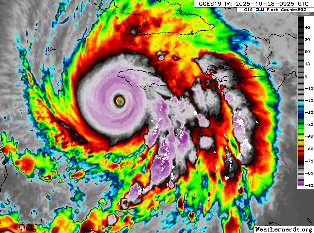
The person who said "880s are still in play" may be devilishly correct since the plane barely entered the eye
5 likes
Sorry for the bad English sometimes...!
For reliable and detailed information for any meteorological phenomenon, please consult the National Hurricane Center, Joint Typhoon Warning Center , or your local Meteo Center.
--------
ECCE OMNIA NOVA FACIAM (Ap 21,5).
For reliable and detailed information for any meteorological phenomenon, please consult the National Hurricane Center, Joint Typhoon Warning Center , or your local Meteo Center.
--------
ECCE OMNIA NOVA FACIAM (Ap 21,5).
-
InfernoFlameCat

- Category 5
- Posts: 2127
- Age: 22
- Joined: Mon Dec 14, 2020 10:52 am
- Location: Buford, GA
Re: NATL: MELISSA - Hurricane - Discussion
What the actual ****
1 likes
I am by no means a professional. DO NOT look at my forecasts for official information or make decisions based on what I post.
Goal: to become a registered expert over tropical and subtropical cyclones.
Goal: to become a registered expert over tropical and subtropical cyclones.

Re: NATL: MELISSA - Hurricane - Discussion
And I thought Milton, the first sub-900 mb storm in almost 20 years, would be 'generational'. This goes above and beyond.
6 likes
-
grapealcoholic
- Category 2

- Posts: 703
- Joined: Tue Aug 10, 2021 3:26 pm
Re: NATL: MELISSA - Hurricane - Discussion
grapealcoholic wrote:880s still in play
Hurricane2022 wrote:The person who said "880s are still in play" may be devilishly correct since the plane barely entered the eye
its not done
Last edited by grapealcoholic on Tue Oct 28, 2025 7:45 am, edited 1 time in total.
2 likes
-
Stormybajan

- Category 1

- Posts: 453
- Joined: Thu May 20, 2021 3:21 pm
- Location: Windward Islands
Re: NATL: MELISSA - Hurricane - Discussion
893 mb extrap.....ummm This might be a worse case scenario for Jamaica's landfall
This will be the FINAL Melissa but this hurricane wont be forgotten by anyone who tracked her.
-2.67 eye at its driest aswell...this is just beyond my wildest expectations
This will be the FINAL Melissa but this hurricane wont be forgotten by anyone who tracked her.
-2.67 eye at its driest aswell...this is just beyond my wildest expectations
Last edited by Stormybajan on Tue Oct 28, 2025 8:24 am, edited 4 times in total.
3 likes
Sad West Indies and Manchester United fan ⚽️
-
TheHurricaneGod
- Tropical Storm

- Posts: 165
- Age: 23
- Joined: Thu Apr 16, 2020 6:19 pm
- Location: Fort Lauderdale

Re: NATL: MELISSA - Hurricane - Discussion
Yesterday people said that Melissa is probably what the 1932 Cuba hurricane would look like on satellite.
Now... This is probably what the 1935 Labor Day hurricane would look like on satellite.

Now... This is probably what the 1935 Labor Day hurricane would look like on satellite.
3 likes
TC naming lists: retirements and intensity
Most aggressive Advisory #1's in North Atlantic (cr. kevin for starting the list)
Most aggressive Advisory #1's in North Atlantic (cr. kevin for starting the list)
Re: NATL: MELISSA - Hurricane - Discussion
This is this generation's Wilma moment. We'll still talk about this storm for decades to come. Unfortunately, unlike Wilma, this one will make landfall at its insane peak intensity. Prayers to all in Jamaica, I don't know what else to say.
8 likes
-
MarioProtVI
- Category 5
- Posts: 1035
- Age: 24
- Joined: Sun Sep 29, 2019 7:33 pm
- Location: New Jersey
Re: NATL: MELISSA - Hurricane - Discussion
What the actual hell. This wasn’t what I expected to wake up to.
2 likes
-
Hurricane2022
- Category 5
- Posts: 2062
- Joined: Tue Aug 23, 2022 11:38 pm
- Location: Araçatuba, Brazil
Re: NATL: MELISSA - Hurricane - Discussion
I can't even imagine what must be going through the minds of the NHC meteorologists. They must all be suffering from violent migraines and stomach upset...
3 likes
Sorry for the bad English sometimes...!
For reliable and detailed information for any meteorological phenomenon, please consult the National Hurricane Center, Joint Typhoon Warning Center , or your local Meteo Center.
--------
ECCE OMNIA NOVA FACIAM (Ap 21,5).
For reliable and detailed information for any meteorological phenomenon, please consult the National Hurricane Center, Joint Typhoon Warning Center , or your local Meteo Center.
--------
ECCE OMNIA NOVA FACIAM (Ap 21,5).

Re: NATL: MELISSA - Hurricane - Discussion
This storm is a perfect nightmare scenario of a climate-induced warm SST future.
3 likes
Igor 2010, Sandy 2012, Fay 2014, Gonzalo 2014, Joaquin 2015, Nicole 2016, Humberto 2019, Imelda 2025
I am only a tropical weather enthusiast. My predictions are not official and may or may not be backed by sound meteorological data. For official information, please refer to the NHC and NWS products.
I am only a tropical weather enthusiast. My predictions are not official and may or may not be backed by sound meteorological data. For official information, please refer to the NHC and NWS products.
Re: NATL: MELISSA - Hurricane - Discussion
If Jamaica wasn’t there and it was making landfall in Cuba instead, I think Melissa would beat both Wilma and Allen for intensity and wind speed.
1 likes

Re: NATL: MELISSA - Hurricane - Discussion
what's the strongest an Atlantic hurricane has been at landfall? 892mb for the labor day hurricane?
1 likes
Re: NATL: MELISSA - Hurricane - Discussion
ATDoel wrote:what's the strongest an Atlantic hurricane has been at landfall? 892mb for the labor day hurricane?
Yes, that's the current record.
2 likes
-
Hurricane2022
- Category 5
- Posts: 2062
- Joined: Tue Aug 23, 2022 11:38 pm
- Location: Araçatuba, Brazil
Re: NATL: MELISSA - Hurricane - Discussion
893.4 extrap.
3 likes
Sorry for the bad English sometimes...!
For reliable and detailed information for any meteorological phenomenon, please consult the National Hurricane Center, Joint Typhoon Warning Center , or your local Meteo Center.
--------
ECCE OMNIA NOVA FACIAM (Ap 21,5).
For reliable and detailed information for any meteorological phenomenon, please consult the National Hurricane Center, Joint Typhoon Warning Center , or your local Meteo Center.
--------
ECCE OMNIA NOVA FACIAM (Ap 21,5).

Re: NATL: MELISSA - Hurricane - Discussion
Teban54 wrote:Yesterday people said that Melissa is probably what the 1932 Cuba hurricane would look like on satellite.
Now... This is probably what the 1935 Labor Day hurricane would look like on satellite.
https://i.imgur.com/Xnp3Q5D.gif
I still think peak Milton is probably a better analog for Labor Day due to the incredibly rapid intensification to an upper-end C5, but yeah, Melissa is probably quite similar as well. Structurally though, I'm not sure you could get a better looking storm outside of the deep WCar though.
3 likes
-
Hypercane_Kyle

- Category 5
- Posts: 3465
- Joined: Sat Mar 07, 2015 7:58 pm
- Location: Cape Canaveral, FL
Re: NATL: MELISSA - Hurricane - Discussion
Entire row of sub-900 pressure. Recon did a double take to verify. 100% confirmed.
10 likes
My posts are my own personal opinion, defer to the National Hurricane Center (NHC) and other NOAA products for decision making during hurricane season.
Re: NATL: MELISSA - Hurricane - Discussion
ATDoel wrote:what's the strongest an Atlantic hurricane has been at landfall? 892mb for the labor day hurricane?
Yeah, that's the record. Although there is a possibility that Labor Day could've been even 10ish mb deeper according to anecdotal accounts, and considering that the 892 reading came from Craig Key and wasn't directly centered in the eye if I remember correctly. Even getting an on-ground reading of 892 is beyond insane.
3 likes
-
Hurricane2022
- Category 5
- Posts: 2062
- Joined: Tue Aug 23, 2022 11:38 pm
- Location: Araçatuba, Brazil
Re: NATL: MELISSA - Hurricane - Discussion
Saved for posterity. History is made!


6 likes
Sorry for the bad English sometimes...!
For reliable and detailed information for any meteorological phenomenon, please consult the National Hurricane Center, Joint Typhoon Warning Center , or your local Meteo Center.
--------
ECCE OMNIA NOVA FACIAM (Ap 21,5).
For reliable and detailed information for any meteorological phenomenon, please consult the National Hurricane Center, Joint Typhoon Warning Center , or your local Meteo Center.
--------
ECCE OMNIA NOVA FACIAM (Ap 21,5).
Re: NATL: MELISSA - Hurricane - Discussion
This is a set of recon obs for the record books, circling in the eye with sub-900 extrap for the full 10 minutes. You wouldn't even be able to do this in a smaller pinhole eye like Wilma and Milton.

1 likes
TC naming lists: retirements and intensity
Most aggressive Advisory #1's in North Atlantic (cr. kevin for starting the list)
Most aggressive Advisory #1's in North Atlantic (cr. kevin for starting the list)
Who is online
Users browsing this forum: No registered users and 15 guests