NATL: HUMBERTO - Remnants - Discussion
Moderator: S2k Moderators
-
Hurricane2022

- Category 5

- Posts: 2083
- Joined: Tue Aug 23, 2022 11:38 pm
- Location: Araçatuba, Brazil
Re: NATL: HUMBERTO - Hurricane - Discussion
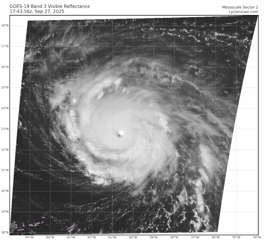
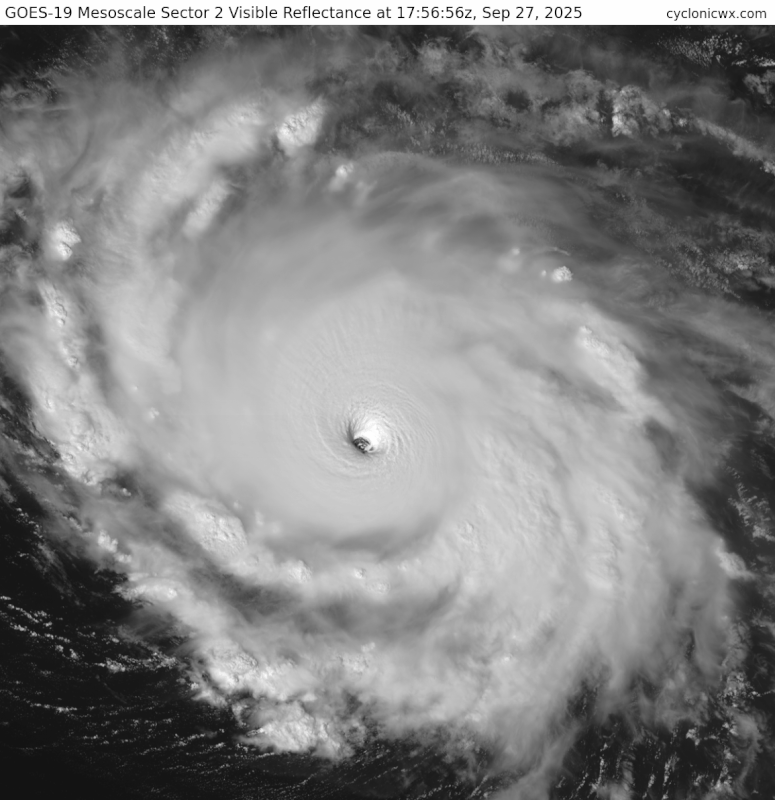
cycloneye wrote:AL, 08, 2025092718, , BEST, 0, 228N, 608W, 135, 926, HU
Yeah for sure this is Sam 2.0. I'm "sure" it's around 140 - 145 kt now.
6 likes
Sorry for the bad English sometimes...!
For reliable and detailed information for any meteorological phenomenon, please consult the National Hurricane Center, Joint Typhoon Warning Center , or your local Meteo Center.
--------
ECCE OMNIA NOVA FACIAM (Ap 21,5).
For reliable and detailed information for any meteorological phenomenon, please consult the National Hurricane Center, Joint Typhoon Warning Center , or your local Meteo Center.
--------
ECCE OMNIA NOVA FACIAM (Ap 21,5).

Re: NATL: HUMBERTO - Hurricane - Discussion
cycloneye wrote:AL, 08, 2025092718, , BEST, 0, 228N, 608W, 135, 926, HU
Fingers crossed they go 5 kt higher for the official advisory like they did several times Thursday and Friday. Although they tend to do that earlier in a system’s life or during initial RI bursts.
3 likes
Irene '11 Sandy '12 Hermine '16 5/15/2018 Derecho Fay '20 Isaias '20 Elsa '21 Henri '21 Ida '21
I am only a meteorology enthusiast who knows a decent amount about tropical cyclones. Look to the professional mets, the NHC, or your local weather office for the best information.
I am only a meteorology enthusiast who knows a decent amount about tropical cyclones. Look to the professional mets, the NHC, or your local weather office for the best information.

Re: NATL: HUMBERTO - Hurricane - Discussion
Wouldn’t be surprised if this is a 145+ kt storm right now. I’d say the satellite presentation looks even more impressive than Erin at her peak, and I don’t recall those eye temps being nearly this high, although I don’t remember for sure. Visually, it reminds me a lot of Irma. Operationally, it reminds me of Sam.
1 likes
-
WaveBreaking

- Category 2

- Posts: 727
- Joined: Sun Jun 30, 2024 11:33 am
- Location: US
Re: NATL: HUMBERTO - Hurricane - Discussion
Ngl I think Humberto is prettier than Erin was at its peak.


9 likes
I am NOT a professional meteorologist, so take all of my posts with a grain of salt. My opinions are mine and mine alone.
-
HurricaneAndre2008

- Category 1

- Posts: 356
- Age: 28
- Joined: Wed Jul 31, 2019 9:51 pm
- Contact:
Re: NATL: HUMBERTO - Hurricane - Discussion
cycloneye wrote:AL, 08, 2025092718, , BEST, 0, 228N, 608W, 135, 926, HU
I think that's a fake fix.
0 likes
Cindy(2005), Katrina(2005), Rita(2005), Erin(2007), Isaac(2012)
-
Sciencerocks
- Category 5
- Posts: 10189
- Age: 40
- Joined: Thu Jul 06, 2017 1:51 am

-
HurricaneAndre2008
- Category 1
- Posts: 356
- Age: 28
- Joined: Wed Jul 31, 2019 9:51 pm
- Contact:
Re: NATL: HUMBERTO - Hurricane - Discussion
TXNT23 KNES 271822
TCSNTL
A. 08L (HUMBERTO)
B. 27/1800Z
C. 22.7N
D. 60.7W
E. ONE/GOES-E
F. T6.5/6.5
G. IR/EIR/VIS
H. REMARKS...MWG EYE SURROUNDED BY W AND EMBEDDED IN B RESULTS IN A DT
OF 6.5. THE MET IS 6.5 BASED ON A RAPIDLY DEVELOPING 24 HOUR TREND. THE
PT IS 6.5. THE FT IS BASED ON THE DT.
I. ADDL POSITIONS
NIL
...MONAGHAN
1 likes
Cindy(2005), Katrina(2005), Rita(2005), Erin(2007), Isaac(2012)

Re: NATL: HUMBERTO - Hurricane - Discussion
T6.5 fix from SAB, somehow that W ring wasn't thick enough.
TXNT23 KNES 271822
TCSNTL
A. 08L (HUMBERTO)
B. 27/1800Z
C. 22.7N
D. 60.7W
E. ONE/GOES-E
F. T6.5/6.5
G. IR/EIR/VIS
H. REMARKS...MWG EYE SURROUNDED BY W AND EMBEDDED IN B RESULTS IN A DT
OF 6.5. THE MET IS 6.5 BASED ON A RAPIDLY DEVELOPING 24 HOUR TREND. THE
PT IS 6.5. THE FT IS BASED ON THE DT.
I. ADDL POSITIONS
NIL
...MONAGHAN
TCSNTL
A. 08L (HUMBERTO)
B. 27/1800Z
C. 22.7N
D. 60.7W
E. ONE/GOES-E
F. T6.5/6.5
G. IR/EIR/VIS
H. REMARKS...MWG EYE SURROUNDED BY W AND EMBEDDED IN B RESULTS IN A DT
OF 6.5. THE MET IS 6.5 BASED ON A RAPIDLY DEVELOPING 24 HOUR TREND. THE
PT IS 6.5. THE FT IS BASED ON THE DT.
I. ADDL POSITIONS
NIL
...MONAGHAN
0 likes
-
CrazyC83
- Professional-Met

- Posts: 34316
- Joined: Tue Mar 07, 2006 11:57 pm
- Location: Deep South, for the first time!
Re: NATL: HUMBERTO - Hurricane - Discussion
It looks T7.0 to me, especially with a hint of CMG and a very warm eye. If the CMG can wrap around, that would be T7.5.
I'd probably even consider 145 kt (if they went there, the pressure would likely be about 918 mb).
I'd probably even consider 145 kt (if they went there, the pressure would likely be about 918 mb).
Last edited by CrazyC83 on Sat Sep 27, 2025 1:47 pm, edited 1 time in total.
3 likes

Re: NATL: HUMBERTO - Hurricane - Discussion
Eye temp is still over 20°C and there are no signs of deterioration / another EWRC at this point. It's possible that if the upward trend in objective estimates holds for a couple more hours, they'll have what they need to make the call at 21z. As a layperson, this seems at the very least close to Erin's presentation at her peak intensity, but I suppose it makes sense to be a little more conservative in the absence of recon data.
1 likes
-
Iceresistance

- Category 5
- Posts: 9605
- Age: 22
- Joined: Sat Oct 10, 2020 9:45 am
- Location: Tecumseh, OK/Norman, OK
Re: NATL: HUMBERTO - Hurricane - Discussion
HurricaneAndre2008 wrote:cycloneye wrote:AL, 08, 2025092718, , BEST, 0, 228N, 608W, 135, 926, HU
I think that's a fake fix.
The real fix just came in
08L HUMBERTO 250927 1800 22.7N 60.7W ATL 135 929
1 likes
Bill 2015 & Beta 2020
Winter 2020-2021
All observations are in Tecumseh, OK unless otherwise noted.
Winter posts are focused mainly for Oklahoma & Texas.
Take any of my forecasts with a grain of salt, refer to the NWS, SPC, and NHC for official information
Never say Never with weather! Because ANYTHING is possible!
Winter 2020-2021
All observations are in Tecumseh, OK unless otherwise noted.
Winter posts are focused mainly for Oklahoma & Texas.
Take any of my forecasts with a grain of salt, refer to the NWS, SPC, and NHC for official information
Never say Never with weather! Because ANYTHING is possible!
-
CrazyC83
- Professional-Met
- Posts: 34316
- Joined: Tue Mar 07, 2006 11:57 pm
- Location: Deep South, for the first time!
Re: NATL: HUMBERTO - Hurricane - Discussion
sasha_B wrote:Eye temp is still over 20°C and there are no signs of deterioration / another EWRC at this point. It's possible that if the upward trend in objective estimates holds for a couple more hours, they'll have what they need to make the call at 21z. As a layperson, this seems at the very least close to Erin's presentation at her peak intensity, but I suppose it makes sense to be a little more conservative in the absence of recon data.
It's very rare for NHC to upgrade to a cat 5 without Recon. I know they famously did for Lorenzo in 2019, but before then Isabel in 2003 was the last time they did.
8 likes
-
Kingarabian

- S2K Supporter

- Posts: 16376
- Joined: Sat Aug 08, 2009 3:06 am
- Location: Honolulu, Hawaii
Re: NATL: HUMBERTO - Hurricane - Discussion
Travorum wrote:T6.5 fix from SAB, somehow that W ring wasn't thick enough.TXNT23 KNES 271822
TCSNTL
A. 08L (HUMBERTO)
B. 27/1800Z
C. 22.7N
D. 60.7W
E. ONE/GOES-E
F. T6.5/6.5
G. IR/EIR/VIS
H. REMARKS...MWG EYE SURROUNDED BY W AND EMBEDDED IN B RESULTS IN A DT
OF 6.5. THE MET IS 6.5 BASED ON A RAPIDLY DEVELOPING 24 HOUR TREND. THE
PT IS 6.5. THE FT IS BASED ON THE DT.
I. ADDL POSITIONS
NIL
...MONAGHAN
Its tough in these situations because the thickness on the W ring has been fluctuating. A CMG ring can help it get a 7.0.
But IMO a T6.5 and a perfect microwave pass means this is a Cat.5.
Last edited by Kingarabian on Sat Sep 27, 2025 1:51 pm, edited 1 time in total.
4 likes
RIP Kobe Bryant
Re: NATL: HUMBERTO - Hurricane - Discussion
An override to *increase* the central pressure estimate seems rather odd in this case. Perhaps the next full advisory will elaborate further on the factors that might be holding Humberto back.
2 likes
Re: NATL: HUMBERTO - Hurricane - Discussion
CrazyC83 wrote:sasha_B wrote:Eye temp is still over 20°C and there are no signs of deterioration / another EWRC at this point. It's possible that if the upward trend in objective estimates holds for a couple more hours, they'll have what they need to make the call at 21z. As a layperson, this seems at the very least close to Erin's presentation at her peak intensity, but I suppose it makes sense to be a little more conservative in the absence of recon data.
It's very rare for NHC to upgrade to a cat 5 without Recon. I know they famously did for Lorenzo in 2019, but before then Isabel in 2003 was the last time they did.
And Lorenzo had a research mission in it that IIRC verified that earlier Dvorak estimates matched the ground truth.
2 likes
-
HurricaneAndre2008
- Category 1
- Posts: 356
- Age: 28
- Joined: Wed Jul 31, 2019 9:51 pm
- Contact:
Re: NATL: HUMBERTO - Hurricane - Discussion
AL, 08, 2025092718, , BEST, 0, 227N, 607W, 135, 929, HU, 64, NEQ, 20, 20, 20, 20, 1011, 170, 10, 0, 0, L, 0, , 0, 0, HUMBERTO, D, 0, , 0, 0, 0, 0, genesis-num, 025
0 likes
Cindy(2005), Katrina(2005), Rita(2005), Erin(2007), Isaac(2012)


-
StormWeather

- Category 1
- Posts: 477
- Joined: Wed Jun 05, 2024 2:34 pm
Re: NATL: HUMBERTO - Hurricane - Discussion
The Raw T# numbers are almost at Category 5 level
Analysis
UW - CIMSS
ADVANCED DVORAK TECHNIQUE
ADT-Version 9.1
Tropical Cyclone Intensity Algorithm
----- Current Analysis -----
Date : 27 SEP 2025 Time : 181019 UTC
Lat : 22:40:48 N Lon : 60:43:47 W
CI# /Pressure/ Vmax
6.6 / 933.3mb/129.6kt
Final T# Adj T# Raw T#
6.6 6.8 6.8
Estimated radius of max. wind based on IR : 16 km
Center Temp : +19.2C Cloud Region Temp : -70.9C
Scene Type : EYE
4 likes
Just an average cyclone tracker
The posts in this forum are NOT official forecasts and should not be used as such. They are just the opinion of the poster and may or may not be backed by sound meteorological data. They are NOT endorsed by any professional institution or storm2k.org. For official information, please refer to the NHC and NWS products
The posts in this forum are NOT official forecasts and should not be used as such. They are just the opinion of the poster and may or may not be backed by sound meteorological data. They are NOT endorsed by any professional institution or storm2k.org. For official information, please refer to the NHC and NWS products
Who is online
Users browsing this forum: JRD and 81 guests