NATL: IMELDA - Models

Moderator: S2k Moderators

Message
Author
User avatar
SFLcane
S2K Supporter
S2K Supporter
Posts: 10279
Age: 47
Joined: Sat Jun 05, 2010 1:44 pm
Location: Lake Worth Florida

Re: NATL: NINE - Models

#281 Postby SFLcane » Fri Sep 26, 2025 11:25 pm

Weathertracker96 wrote:If the gfs keeps trending the way it is, parts of FL east coast could receive rain bands from this. It seems each run gets closer to coast which may help the Carolinas


Indeed! Early 00z shift about 50 miles W from 18z. Getting very close now for impacts on the eastcoast.

Close shave with florida and out.
2 likes   

shah83
Category 1
Category 1
Posts: 306
Joined: Sun Jul 31, 2016 4:55 pm

Re: NATL: NINE - Models

#282 Postby shah83 » Fri Sep 26, 2025 11:25 pm

I wonder what happens if future imelda is ever slower and further west...does the fujiwara still happen to our advantage?
0 likes   

AxaltaRacing24
Category 5
Category 5
Posts: 1772
Age: 25
Joined: Wed Jul 27, 2016 11:14 am
Location: Jupiter, FL

Re: NATL: NINE - Models

#283 Postby AxaltaRacing24 » Fri Sep 26, 2025 11:27 pm

this thing gets closer to florida on every single run. it’s subtle, but it’s there.
2 likes   

User avatar
SFLcane
S2K Supporter
S2K Supporter
Posts: 10279
Age: 47
Joined: Sat Jun 05, 2010 1:44 pm
Location: Lake Worth Florida

Re: NATL: NINE - Models

#284 Postby SFLcane » Fri Sep 26, 2025 11:30 pm

AxaltaRacing24 wrote:this thing gets closer to florida on every single run. it’s subtle, but it’s there.


Image
0 likes   

LarryWx
S2K Supporter
S2K Supporter
Posts: 6825
Joined: Sun Sep 07, 2003 2:04 pm
Location: GA

Re: NATL: NINE - Models

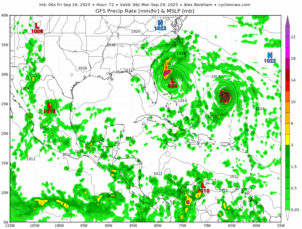
#285 Postby LarryWx » Fri Sep 26, 2025 11:31 pm

0Z JMA at 72 (limit for 0Z) implies later absorption by the much stronger pretty nearby Humberto

0Z CMC stays OTS unlike 12Z, which looped back to NC.

Edit: But CMC later does turn N and hit E MA!
Last edited by LarryWx on Fri Sep 26, 2025 11:53 pm, edited 1 time in total.
0 likes   
Personal Forecast Disclaimer:
The posts in this forum are NOT official forecasts and should not be used as such. They are just the opinion of the poster and may or may not be backed by sound meteorological data. They are NOT endorsed by any professional institution or storm2k.org. For official information, please refer to the NHC and NWS products.

Weathertracker96
Tropical Storm
Tropical Storm
Posts: 150
Joined: Mon Oct 16, 2023 3:41 pm

Re: NATL: NINE - Models

#286 Postby Weathertracker96 » Fri Sep 26, 2025 11:37 pm

SFLcane wrote:
AxaltaRacing24 wrote:this thing gets closer to florida on every single run. it’s subtle, but it’s there.


https://i.postimg.cc/g2b2Ffm3/fffff.gif


Even some of the ensembles for the GFS have moved left. Will be interesting to see how this plays out.
1 likes   

CycloysisNegative
Tropical Low
Tropical Low
Posts: 27
Joined: Fri Jul 05, 2024 11:36 am
Location: Summerville, SC

Re: NATL: NINE - Models

#287 Postby CycloysisNegative » Fri Sep 26, 2025 11:46 pm

BobHarlem wrote:No US landfall on 0z gfs, although it barely dodges Bermuda on the way out.


It then doubles back and smacks it from the east!
0 likes   

CycloysisNegative
Tropical Low
Tropical Low
Posts: 27
Joined: Fri Jul 05, 2024 11:36 am
Location: Summerville, SC

Re: NATL: NINE - Models

#288 Postby CycloysisNegative » Sat Sep 27, 2025 12:34 am

Just to keep things interesting, the euro ai has Imelda make landfall in southern SC
0 likes   

LarryWx
S2K Supporter
S2K Supporter
Posts: 6825
Joined: Sun Sep 07, 2003 2:04 pm
Location: GA

Re: NATL: NINE - Models

#289 Postby LarryWx » Sat Sep 27, 2025 12:43 am

0Z Euro stays away from the US.
0 likes   
Personal Forecast Disclaimer:
The posts in this forum are NOT official forecasts and should not be used as such. They are just the opinion of the poster and may or may not be backed by sound meteorological data. They are NOT endorsed by any professional institution or storm2k.org. For official information, please refer to the NHC and NWS products.

User avatar
cycloneye
Admin
Admin
Posts: 147987
Age: 69
Joined: Thu Oct 10, 2002 10:54 am
Location: San Juan, Puerto Rico

Re: NATL: NINE - Models

#290 Postby cycloneye » Sat Sep 27, 2025 5:18 am

GFS slightly closer to the east coast of Florida in trend of past three runs.

Image
1 likes   
Visit the Caribbean-Central America Weather Thread where you can find at first post web cams,radars
and observations from Caribbean basin members Click Here

User avatar
Beef Stew
Category 2
Category 2
Posts: 535
Joined: Sat May 30, 2020 11:31 am
Location: South Florida

Re: NATL: NINE - Models

#291 Postby Beef Stew » Sat Sep 27, 2025 5:25 am

If this really does stall and stay offshore, it will be a massive win for the ICON (and UKMet) which have been more or less set on this solution for the past couple of days.
2 likes   

tolakram
Admin
Admin
Posts: 20124
Age: 62
Joined: Sun Aug 27, 2006 8:23 pm
Location: Florence, KY (name is Mark)

Re: NATL: NINE - Models

#292 Postby tolakram » Sat Sep 27, 2025 5:30 am

... and now the Euro AI makes landfall.

:spam:

or not?
0 likes   
M a r k
- - - - -
Join us in chat: Storm2K Chatroom Invite. Android and IOS apps also available.

The posts in this forum are NOT official forecasts and should not be used as such. Posts are NOT endorsed by any professional institution or STORM2K.org. For official information and forecasts, please refer to NHC and NWS products.

User avatar
cycloneye
Admin
Admin
Posts: 147987
Age: 69
Joined: Thu Oct 10, 2002 10:54 am
Location: San Juan, Puerto Rico

Re: NATL: NINE - Models

#293 Postby cycloneye » Sat Sep 27, 2025 5:41 am

tolakram wrote:... and now the Euro AI makes landfall.

:spam:

or not?


At the end, yes it makes landfall.

Image
0 likes   
Visit the Caribbean-Central America Weather Thread where you can find at first post web cams,radars
and observations from Caribbean basin members Click Here

User avatar
cycloneye
Admin
Admin
Posts: 147987
Age: 69
Joined: Thu Oct 10, 2002 10:54 am
Location: San Juan, Puerto Rico

Re: NATL: NINE - Models

#294 Postby cycloneye » Sat Sep 27, 2025 5:54 am

The AI ensembles have landfall.

Image
0 likes   
Visit the Caribbean-Central America Weather Thread where you can find at first post web cams,radars
and observations from Caribbean basin members Click Here

caneman
Category 5
Category 5
Posts: 1478
Joined: Fri Sep 05, 2014 5:44 am
Location: Clearwater Beach, Fl

Re: NATL: NINE - Models

#295 Postby caneman » Sat Sep 27, 2025 5:56 am

cycloneye wrote:The AI ensembles have landfall.

https://i.imgur.com/JhKXBnG.jpeg


Another 30 to 50 miles west and SE Florida will get some pretty good effects.
0 likes   

User avatar
Travorum
Category 2
Category 2
Posts: 544
Joined: Tue Sep 05, 2023 9:36 am
Location: Dunedin, FL

Re: NATL: NINE - Models

#296 Postby Travorum » Sat Sep 27, 2025 6:07 am

06z ICON agrees to meet 06z GFS in the middle and both take the system north of Florida before heading east towards Bermuda. Now its the AI models that are more confident on a landfall scenario.
0 likes   

User avatar
cycloneye
Admin
Admin
Posts: 147987
Age: 69
Joined: Thu Oct 10, 2002 10:54 am
Location: San Juan, Puerto Rico

Re: NATL: NINE - Models

#297 Postby cycloneye » Sat Sep 27, 2025 6:37 am

06z EURO AIFS after twits and turns, makes landfall in Outerbanks and goes up to Virginia.


Image
0 likes   
Visit the Caribbean-Central America Weather Thread where you can find at first post web cams,radars
and observations from Caribbean basin members Click Here

User avatar
Travorum
Category 2
Category 2
Posts: 544
Joined: Tue Sep 05, 2023 9:36 am
Location: Dunedin, FL

Re: NATL: NINE - Models

#298 Postby Travorum » Sat Sep 27, 2025 6:44 am

0z HAFS multistorm pulls 9L east similar to ICON and GFS, gets down into the 960s and goes just south of Bermuda

Image
2 likes   

User avatar
Hypercane_Kyle
Category 5
Category 5
Posts: 3411
Joined: Sat Mar 07, 2015 7:58 pm
Location: Cape Canaveral, FL

Re: NATL: NINE - Models

#299 Postby Hypercane_Kyle » Sat Sep 27, 2025 6:56 am

Just based on the latest trends with the GFS, the overall probability of Humberto tugging it away from mainland USA is going up; but the impacts to far Eastern Florida and the Bahamas appear to be growing.
5 likes   
My posts are my own personal opinion, defer to the National Hurricane Center (NHC) and other NOAA products for decision making during hurricane season.

User avatar
ronjon
Category 5
Category 5
Posts: 4877
Joined: Fri Aug 19, 2005 5:17 pm
Location: Hernando Beach, FL

Re: NATL: NINE - Models

#300 Postby ronjon » Sat Sep 27, 2025 7:51 am

The 06z hurricane dynamic models now all show an OTS scenario except HMON. Looks like nearly all models now showing no US landfall and an OTS scenario. Good news for the Carolinas.
2 likes   


Return to “2025”

Who is online

Users browsing this forum: No registered users and 25 guests