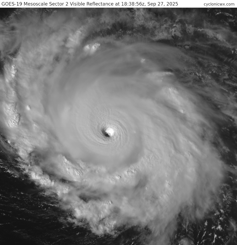
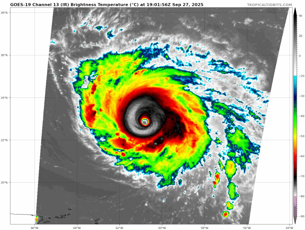
NATL: HUMBERTO - Remnants - Discussion

Moderator: S2k Moderators

Message
Author
TallyTracker
Category 2
Category 2
Posts: 769
Joined: Thu Oct 11, 2018 2:46 pm

Re: NATL: HUMBERTO - Hurricane - Discussion

#301 Postby TallyTracker » Sat Sep 27, 2025 1:55 pm


That is rare form for an Atlantic hurricane. I’d be stunned if this is not a Cat 5 and likely more than borderline at that.
4 likes   
Fran '96, Georges '98, Gordon '00, Gabrielle '01, Charley '04, Frances '04, Jeanne '04, Barry '07, Fay '08, Debby '12, Matthew '16, Emily '17, Irma '17, Michael ‘18, Elsa ‘21, Fred ‘21, Mindy ‘21, Nicole ‘22, Idalia ‘23, Debby ‘24, Helene ‘24

MarioProtVI
Category 5
Category 5
Posts: 1002
Age: 24
Joined: Sun Sep 29, 2019 7:33 pm
Location: New Jersey

Re: NATL: HUMBERTO - Hurricane - Discussion

#302 Postby MarioProtVI » Sat Sep 27, 2025 1:56 pm

aspen wrote:
cycloneye wrote:
AL, 08, 2025092718, , BEST, 0, 228N, 608W, 135, 926, HU

Fingers crossed they go 5 kt higher for the official advisory like they did several times Thursday and Friday. Although they tend to do that earlier in a system’s life or during initial RI bursts.

Highly doubt so as I’m already starting to see signs of an EWRC kicking in on IR. They’re not gonna upgrade it until it gets a SAB/ADT 7.0 which it very likely won’t.
0 likes   

User avatar
Beef Stew
Category 2
Category 2
Posts: 533
Joined: Sat May 30, 2020 11:31 am
Location: South Florida

Re: NATL: HUMBERTO - Hurricane - Discussion

#303 Postby Beef Stew » Sat Sep 27, 2025 1:57 pm

CrazyC83 wrote:
sasha_B wrote:Eye temp is still over 20°C and there are no signs of deterioration / another EWRC at this point. It's possible that if the upward trend in objective estimates holds for a couple more hours, they'll have what they need to make the call at 21z. As a layperson, this seems at the very least close to Erin's presentation at her peak intensity, but I suppose it makes sense to be a little more conservative in the absence of recon data.


It's very rare for NHC to upgrade to a cat 5 without Recon. I know they famously did for Lorenzo in 2019, but before then Isabel in 2003 was the last time they did.


This is why I was so surprised earlier when they explicitly forecast a 140 kt peak given the lack of recon that would be in the storm. I thought they may be setting the stage to justify an upgrade to cat 5 based on satellite, but then they backed back down to a 135 kt peak in the last advisory (which is also confusing to me), so I feel like they won’t be going any higher than that operationally.
3 likes   

zhukm29
Category 1
Category 1
Posts: 351
Joined: Tue Aug 28, 2018 2:37 pm

Re: NATL: HUMBERTO - Hurricane - Discussion

#304 Postby zhukm29 » Sat Sep 27, 2025 2:01 pm

TAFB just came in at 140kts:
https://ftp.nhc.noaa.gov/atcf/fix/fal082025.dat

AL, 08, 202509271800, 10, DVTS, CI, , 2280N, 6060W, , 1, 140, 2, 921, 2, DVRK, , , , , , , , , , , , , , L, TAFB, SK, VI, 1, 7070 /////, , , GOES19, CSC, T,
7 likes   

User avatar
WaveBreaking
Category 2
Category 2
Posts: 627
Joined: Sun Jun 30, 2024 11:33 am
Location: US

Re: NATL: HUMBERTO - Hurricane - Discussion

#305 Postby WaveBreaking » Sat Sep 27, 2025 2:02 pm

I think an EWRC is starting to happen based on the slight trochoidal eye motion, the shrinking eye, and even the CDO getting cooler. Usually the CDO gets warmer before an EWRC, but I think this might a case like Erin and Milton where the outer eyewall starts throwing up very deep convection before the inner eyewall dissipates.


Image
Last edited by WaveBreaking on Sat Sep 27, 2025 2:03 pm, edited 1 time in total.
2 likes   
I am NOT a professional meteorologist, so take all of my posts with a grain of salt. My opinions are mine and mine alone.

User avatar
Kingarabian
S2K Supporter
S2K Supporter
Posts: 16261
Joined: Sat Aug 08, 2009 3:06 am
Location: Honolulu, Hawaii

Re: NATL: HUMBERTO - Hurricane - Discussion

#306 Postby Kingarabian » Sat Sep 27, 2025 2:02 pm

Travorum wrote:T6.5 fix from SAB, somehow that W ring wasn't thick enough.

TXNT23 KNES 271822
TCSNTL

A. 08L (HUMBERTO)

B. 27/1800Z

C. 22.7N

D. 60.7W

E. ONE/GOES-E

F. T6.5/6.5

G. IR/EIR/VIS

H. REMARKS...MWG EYE SURROUNDED BY W AND EMBEDDED IN B RESULTS IN A DT
OF 6.5. THE MET IS 6.5 BASED ON A RAPIDLY DEVELOPING 24 HOUR TREND. THE
PT IS 6.5. THE FT IS BASED ON THE DT.

I. ADDL POSITIONS

NIL


...MONAGHAN

I've seen some outrageous SAB fixes but this one makes sense. Its unfortunately not a clear cut 7.0 on the Dvorak scale.
5 likes   
RIP Kobe Bryant

User avatar
StormWeather
Category 1
Category 1
Posts: 442
Joined: Wed Jun 05, 2024 2:34 pm

Re: NATL: HUMBERTO - Hurricane - Discussion

#307 Postby StormWeather » Sat Sep 27, 2025 2:02 pm

zhukm29 wrote:TAFB just came in at 140kts:
https://ftp.nhc.noaa.gov/atcf/fix/fal082025.dat

AL, 08, 202509271800, 10, DVTS, CI, , 2280N, 6060W, , 1, 140, 2, 921, 2, DVRK, , , , , , , , , , , , , , L, TAFB, SK, VI, 1, 7070 /////, , , GOES19, CSC, T,

So what does this mean? Is there a higher chance of seeing the NHC go for the 5?
0 likes   
Just an average cyclone tracker

The posts in this forum are NOT official forecasts and should not be used as such. They are just the opinion of the poster and may or may not be backed by sound meteorological data. They are NOT endorsed by any professional institution or storm2k.org. For official information, please refer to the NHC and NWS products

User avatar
Yellow Evan
Professional-Met
Professional-Met
Posts: 16198
Age: 27
Joined: Fri Jul 15, 2011 12:48 pm
Location: Henderson, Nevada/Honolulu, HI
Contact:

Re: NATL: HUMBERTO - Hurricane - Discussion

#308 Postby Yellow Evan » Sat Sep 27, 2025 2:06 pm

SAB did not fix this correctly by all accounts. W ring was >.5 degrees even if a spec of B appeared on the north.
5 likes   

User avatar
Kingarabian
S2K Supporter
S2K Supporter
Posts: 16261
Joined: Sat Aug 08, 2009 3:06 am
Location: Honolulu, Hawaii

Re: NATL: HUMBERTO - Hurricane - Discussion

#309 Postby Kingarabian » Sat Sep 27, 2025 2:06 pm

StormWeather wrote:
zhukm29 wrote:TAFB just came in at 140kts:
https://ftp.nhc.noaa.gov/atcf/fix/fal082025.dat

AL, 08, 202509271800, 10, DVTS, CI, , 2280N, 6060W, , 1, 140, 2, 921, 2, DVRK, , , , , , , , , , , , , , L, TAFB, SK, VI, 1, 7070 /////, , , GOES19, CSC, T,

So what does this mean? Is there a higher chance of seeing the NHC go for the 5?


The blend of SAB/ADT/TAFB CURRENTLY support a blend of 135kts. If ADT can get up to 7.0 by 5pm they will likely pull the trigger. Even if ADT stays at 6.8 or lower they may pull the trigger at 5 pm because the most recent microwave pass was really impressive, and that depiction is only associated with upper echelon hurricanes.
8 likes   
RIP Kobe Bryant

User avatar
Teban54
Category 5
Category 5
Posts: 3524
Joined: Sat May 19, 2018 1:19 pm

Re: NATL: HUMBERTO - Hurricane - Discussion

#310 Postby Teban54 » Sat Sep 27, 2025 2:11 pm

Image
8 likes   

bob rulz
Category 5
Category 5
Posts: 1709
Age: 35
Joined: Sat Jan 28, 2006 7:30 pm
Location: Salt Lake City, Utah

Re: NATL: HUMBERTO - Hurricane - Discussion

#311 Postby bob rulz » Sat Sep 27, 2025 2:17 pm

This is a cat 5 if I've ever seen one.
1 likes   

User avatar
ScottNAtlanta
Category 5
Category 5
Posts: 2468
Joined: Sat May 25, 2013 3:11 pm
Location: Atlanta, GA

Re: NATL: HUMBERTO - Hurricane - Discussion

#312 Postby ScottNAtlanta » Sat Sep 27, 2025 2:26 pm


Beautiful example of the stadium effect
1 likes   
The posts in this forum are NOT official forecast and should not be used as such. They are just the opinion of the poster and may or may not be backed by sound meteorological data. They are NOT endorsed by any professional institution or storm2k.org. For official information, please refer to the NHC and NWS products.

User avatar
aspen
Category 5
Category 5
Posts: 8918
Joined: Sat Oct 12, 2019 7:10 pm
Location: Connecticut, USA

Re: NATL: HUMBERTO - Hurricane - Discussion

#313 Postby aspen » Sat Sep 27, 2025 2:31 pm

Kingarabian wrote:
Travorum wrote:T6.5 fix from SAB, somehow that W ring wasn't thick enough.

TXNT23 KNES 271822
TCSNTL

A. 08L (HUMBERTO)

B. 27/1800Z

C. 22.7N

D. 60.7W

E. ONE/GOES-E

F. T6.5/6.5

G. IR/EIR/VIS

H. REMARKS...MWG EYE SURROUNDED BY W AND EMBEDDED IN B RESULTS IN A DT
OF 6.5. THE MET IS 6.5 BASED ON A RAPIDLY DEVELOPING 24 HOUR TREND. THE
PT IS 6.5. THE FT IS BASED ON THE DT.

I. ADDL POSITIONS

NIL


...MONAGHAN
I've seen some outrageous SAB fixes but this one makes sense. Its unfortunately not a clear cut 7.0 on the Dvorak scale.

I’m curious, why does this fall just below a clear-cut 7.0?
0 likes   
Irene '11 Sandy '12 Hermine '16 5/15/2018 Derecho Fay '20 Isaias '20 Elsa '21 Henri '21 Ida '21

I am only a meteorology enthusiast who knows a decent amount about tropical cyclones. Look to the professional mets, the NHC, or your local weather office for the best information.

User avatar
Ubuntwo
Category 5
Category 5
Posts: 1429
Age: 31
Joined: Thu Oct 05, 2017 10:41 pm

Re: NATL: HUMBERTO - Hurricane - Discussion

#314 Postby Ubuntwo » Sat Sep 27, 2025 2:36 pm

aspen wrote:
Kingarabian wrote:
aspen wrote:Knew they were going to go with T6.5.

Sometimes I wonder if they’re even looking at the same imagery as we are (I know that ADT’s Dvorak imagery is slightly different than on TT for some reason).

I've seen some outrageous SAB fixes but this one makes sense. Its unfortunately not a clear cut 7.0 on the Dvorak scale.

I’m curious, why does this fall just below a clear-cut 7.0?

The 18z frame had several blips in the W ring on the north side, which subjectively could prevent the eye from being truly "embedded in W". This was a case of bad timing, as prior to and especially after that frame, the break filled in.
3 likes   
Kendall -> SLO -> PBC

Memorable Storms: Katrina (for its Florida landfall...) Wilma Matthew Irma

User avatar
Teban54
Category 5
Category 5
Posts: 3524
Joined: Sat May 19, 2018 1:19 pm

Re: NATL: HUMBERTO - Hurricane - Discussion

#315 Postby Teban54 » Sat Sep 27, 2025 2:42 pm

Recent frames are looking more plausibly like an EWRC.

Image
1 likes   

User avatar
Yellow Evan
Professional-Met
Professional-Met
Posts: 16198
Age: 27
Joined: Fri Jul 15, 2011 12:48 pm
Location: Henderson, Nevada/Honolulu, HI
Contact:

Re: NATL: HUMBERTO - Hurricane - Discussion

#316 Postby Yellow Evan » Sat Sep 27, 2025 2:43 pm

Ubuntwo wrote:
aspen wrote:
Kingarabian wrote:I've seen some outrageous SAB fixes but this one makes sense. Its unfortunately not a clear cut 7.0 on the Dvorak scale.

I’m curious, why does this fall just below a clear-cut 7.0?

The 18z frame had several blips in the W ring on the north side, which subjectively could prevent the eye from being truly "embedded in W". This was a case of bad timing, as prior to and especially after that frame, the break filled in.


Even with the B spec (which probably wouldn’t show up on 4 km imagery), the W ring was still greater than .5 degrees though.
1 likes   

zhukm29
Category 1
Category 1
Posts: 351
Joined: Tue Aug 28, 2018 2:37 pm

Re: NATL: HUMBERTO - Hurricane - Discussion

#317 Postby zhukm29 » Sat Sep 27, 2025 2:48 pm

Some images for posterity:

Image
Image
Image
15 likes   

zzzh
Category 4
Category 4
Posts: 938
Joined: Thu Sep 02, 2021 1:13 pm

Re: NATL: HUMBERTO - Hurricane - Discussion

#318 Postby zzzh » Sat Sep 27, 2025 2:50 pm

1 likes   

User avatar
StormWeather
Category 1
Category 1
Posts: 442
Joined: Wed Jun 05, 2024 2:34 pm

Re: NATL: HUMBERTO - Hurricane - Discussion

#319 Postby StormWeather » Sat Sep 27, 2025 2:53 pm

T#6.7 now

UW - CIMSS
ADVANCED DVORAK TECHNIQUE
ADT-Version 9.1
Tropical Cyclone Intensity Algorithm

----- Current Analysis -----
Date : 27 SEP 2025 Time : 191019 UTC
Lat : 22:45:00 N Lon : 60:51:36 W


CI# /Pressure/ Vmax
6.7 / 931.0mb/132.2kt


Final T# Adj T# Raw T#
6.7 6.7 6.7

Estimated radius of max. wind based on IR : 17 km

Center Temp : +19.9C Cloud Region Temp : -70.7C

Scene Type : EYE

Subtropical Adjustment : OFF

Extratropical Adjustment : OFF

Positioning Method : ARCHER POSITIONING

Ocean Basin : ATLANTIC
Dvorak CI > MSLP Conversion Used : CKZ Method

Tno/CI Rules : Constraint Limits : NO LIMIT
Weakening Flag : OFF
Rapid Dissipation Flag : OFF

C/K/Z MSLP Estimate Inputs :
- Average 34 knot radii : 97nmi
- Environmental MSLP : 1011mb

Satellite Name : GOES19
Satellite Viewing Angle : 31.1 degrees
0 likes   
Just an average cyclone tracker

The posts in this forum are NOT official forecasts and should not be used as such. They are just the opinion of the poster and may or may not be backed by sound meteorological data. They are NOT endorsed by any professional institution or storm2k.org. For official information, please refer to the NHC and NWS products

zhukm29
Category 1
Category 1
Posts: 351
Joined: Tue Aug 28, 2018 2:37 pm

Re: NATL: HUMBERTO - Hurricane - Discussion

#320 Postby zhukm29 » Sat Sep 27, 2025 2:54 pm

0 likes   


Return to “2025”

Who is online

Users browsing this forum: No registered users and 53 guests