ATL: Ex-INVEST 91L - Models

Moderator: S2k Moderators

Message
Author
User avatar
Teban54
Category 5
Category 5
Posts: 3314
Joined: Sat May 19, 2018 1:19 pm

Re: ATL: INVEST 91L - Models

#81 Postby Teban54 » Thu Sep 04, 2025 2:37 pm

tolakram wrote:
sma10 wrote:
LarryWx wrote:12Z:
-Euro: TS that later weakens to a weak low as it crosses the Lesser Antilles and then goes through N Caribbean disorganized/very weak

-UKMET: no TC again/low too weak to be classified a TD


I find it interesting as well that the Euro AI model has consistently shown no development at all


What is the artificial intelligence that this model is using, just past storms? Unless I see evidence otherwise the AI models are just climatological likelihoods with maybe some recency bias throw in for good measure.

Deep learning: AIFS is a deep learning system trained on historical weather data.

Data sources: It uses the same observational initial conditions as ECMWF's traditional physics-based model. This includes data from satellites, aircraft, buoys, and other measurement stations.
High performance: AIFS offers significant advantages in speed and energy efficiency, allowing it to generate forecasts much faster and with a lower computational footprint than traditional methods.


source: https://www.ecmwf.int/en/about/media-centre/news/2025/ecmwfs-ai-forecasts-become-operational#:~:text=The%20AIFS%20uses%20the%20same,more%20than%20thirty%20years%20ago.

This is an over-simplistic view of what AI does, even though it's not totally inaccurate. I consider AI as "patterm finding on steroids": its use of "historical weather data" isn't solely about "what an average storm at 16N 50W would do on September 9", but "what an average storm at 16N 50W on September with XX relative humidity, YY shear, ZZ SST etc would do", for example. The actual "indicators" are way more complicated -- most AI models nowadays learn to pick up the indicators and their relative importance themselves, and they're often expressed as billions of numerical parameters in a neural network that's unexplainable to humans.

This applies to most AI models in general, not just weather models.
0 likes   

tolakram
Admin
Admin
Posts: 20047
Age: 62
Joined: Sun Aug 27, 2006 8:23 pm
Location: Florence, KY (name is Mark)

Re: ATL: INVEST 91L - Models

#82 Postby tolakram » Thu Sep 04, 2025 2:45 pm

Teban54 wrote:This is an over-simplistic view of what AI does, even though it's not totally inaccurate. I consider AI as "patterm finding on steroids": its use of "historical weather data" isn't solely about "what an average storm at 16N 50W would do on September 9", but "what an average storm at 16N 50W on September with XX relative humidity, YY shear, ZZ SST etc would do", for example. The actual "indicators" are way more complicated -- most AI models nowadays learn to pick up the indicators and their relative importance themselves, and they're often expressed as billions of numerical parameters in a neural network that's unexplainable to humans.

This applies to most AI models in general, not just weather models.


I don't disagree, but even with a rapid learning system in place how long will it take and are we collecting the right data? Data collection has not changed, that's the hard part. Get recon in the picture and the models change, get some high level recon data and they change more. The AI model can consume and forecast with this data faster but it will still change based on the quality and timing of the data.
1 likes   
M a r k
- - - - -
Join us in chat: Storm2K Chatroom Invite. Android and IOS apps also available.

The posts in this forum are NOT official forecasts and should not be used as such. Posts are NOT endorsed by any professional institution or STORM2K.org. For official information and forecasts, please refer to NHC and NWS products.

BobHarlem
Category 5
Category 5
Posts: 2412
Joined: Thu Oct 20, 2005 6:11 pm

Re: ATL: INVEST 91L - Models

#83 Postby BobHarlem » Thu Sep 04, 2025 2:55 pm

First set of earlies
Image

Image
0 likes   

User avatar
cycloneye
Admin
Admin
Posts: 146580
Age: 69
Joined: Thu Oct 10, 2002 10:54 am
Location: San Juan, Puerto Rico

Re: ATL: INVEST 91L - Models

#84 Postby cycloneye » Thu Sep 04, 2025 3:03 pm

0 likes   
Visit the Caribbean-Central America Weather Thread where you can find at first post web cams,radars
and observations from Caribbean basin members Click Here

User avatar
Hypercane_Kyle
Category 5
Category 5
Posts: 3389
Joined: Sat Mar 07, 2015 7:58 pm
Location: Cape Canaveral, FL

Re: ATL: INVEST 91L - Models

#85 Postby Hypercane_Kyle » Thu Sep 04, 2025 3:54 pm

https://x.com/DerekOrtt/status/1963692783736164515

Derek may be right here but I think he forgets Dorian. I remember when the Euro and its ensembles were Dorian's #1 hater.
1 likes   
My posts are my own personal opinion, defer to the National Hurricane Center (NHC) and other NOAA products for decision making during hurricane season.

User avatar
cycloneye
Admin
Admin
Posts: 146580
Age: 69
Joined: Thu Oct 10, 2002 10:54 am
Location: San Juan, Puerto Rico

Re: ATL: INVEST 91L - Models

#86 Postby cycloneye » Thu Sep 04, 2025 3:57 pm

Interesting point about the low SW of 91L and how the models handle that.

 https://x.com/NDGMETCHEF/status/1963698195760038367

0 likes   
Visit the Caribbean-Central America Weather Thread where you can find at first post web cams,radars
and observations from Caribbean basin members Click Here

User avatar
Teban54
Category 5
Category 5
Posts: 3314
Joined: Sat May 19, 2018 1:19 pm

Re: ATL: INVEST 91L - Models

#87 Postby Teban54 » Thu Sep 04, 2025 3:58 pm

cycloneye wrote:Intresting point about the low SW of 91L and how the models handle that.

 https://x.com/NDGMETCHEF/status/1963698195760038367


FWIW, I've made a new post about that feature at 45W WSW of 91L.
3 likes   

User avatar
Kazmit
Category 5
Category 5
Posts: 2143
Age: 22
Joined: Mon Jul 25, 2016 8:49 am
Location: Bermuda

Re: ATL: INVEST 91L - Models

#88 Postby Kazmit » Thu Sep 04, 2025 5:37 pm

18z GFS is looking like a weaker Maria so far.
0 likes   
Igor 2010, Sandy 2012, Fay 2014, Gonzalo 2014, Joaquin 2015, Nicole 2016, Humberto 2019

I am only a tropical weather enthusiast. My predictions are not official and may or may not be backed by sound meteorological data. For official information, please refer to the NHC and NWS products.

Stratton23
Category 5
Category 5
Posts: 2732
Joined: Fri Jul 21, 2023 10:59 pm
Location: Katy, Tx

Re: ATL: INVEST 91L - Models

#89 Postby Stratton23 » Thu Sep 04, 2025 5:47 pm

Safe bet its going to be another week before details can be ironed out, such an incredibly complex steering pattern on the GFS 18z
2 likes   

TampaWxLurker
Tropical Storm
Tropical Storm
Posts: 171
Joined: Thu Aug 01, 2024 8:20 am

Re: ATL: INVEST 91L - Models

#90 Postby TampaWxLurker » Thu Sep 04, 2025 6:01 pm

18z GFS pulls a 180. Goes over PR, approaches the southern Bahamas, then...turns northeast and out to sea. Although it looks like it's headed to Bermuda.
0 likes   

Pelicane
Tropical Storm
Tropical Storm
Posts: 149
Joined: Tue Sep 13, 2022 1:52 pm
Location: Lafayette, Louisiana

Re: ATL: INVEST 91L - Models

#91 Postby Pelicane » Thu Sep 04, 2025 6:06 pm

Not to beat a dead horse, but still not much ensemble support for this on the GFS. Perhaps because it's a smaller system, but I'd expect a larger signal given what the ops has been showing. Long-term, very uncertain but positive to see more troughing this go around. Looks like the strength of the cutoff low may correlate with the ability for the trough to dig down more, just from eyeballing the past model runs it looks like the stronger the low the less the trough digs down.
0 likes   

lsuhurricane
Category 1
Category 1
Posts: 269
Joined: Tue Aug 15, 2017 2:53 pm

Re: ATL: INVEST 91L - Models

#92 Postby lsuhurricane » Thu Sep 04, 2025 6:10 pm

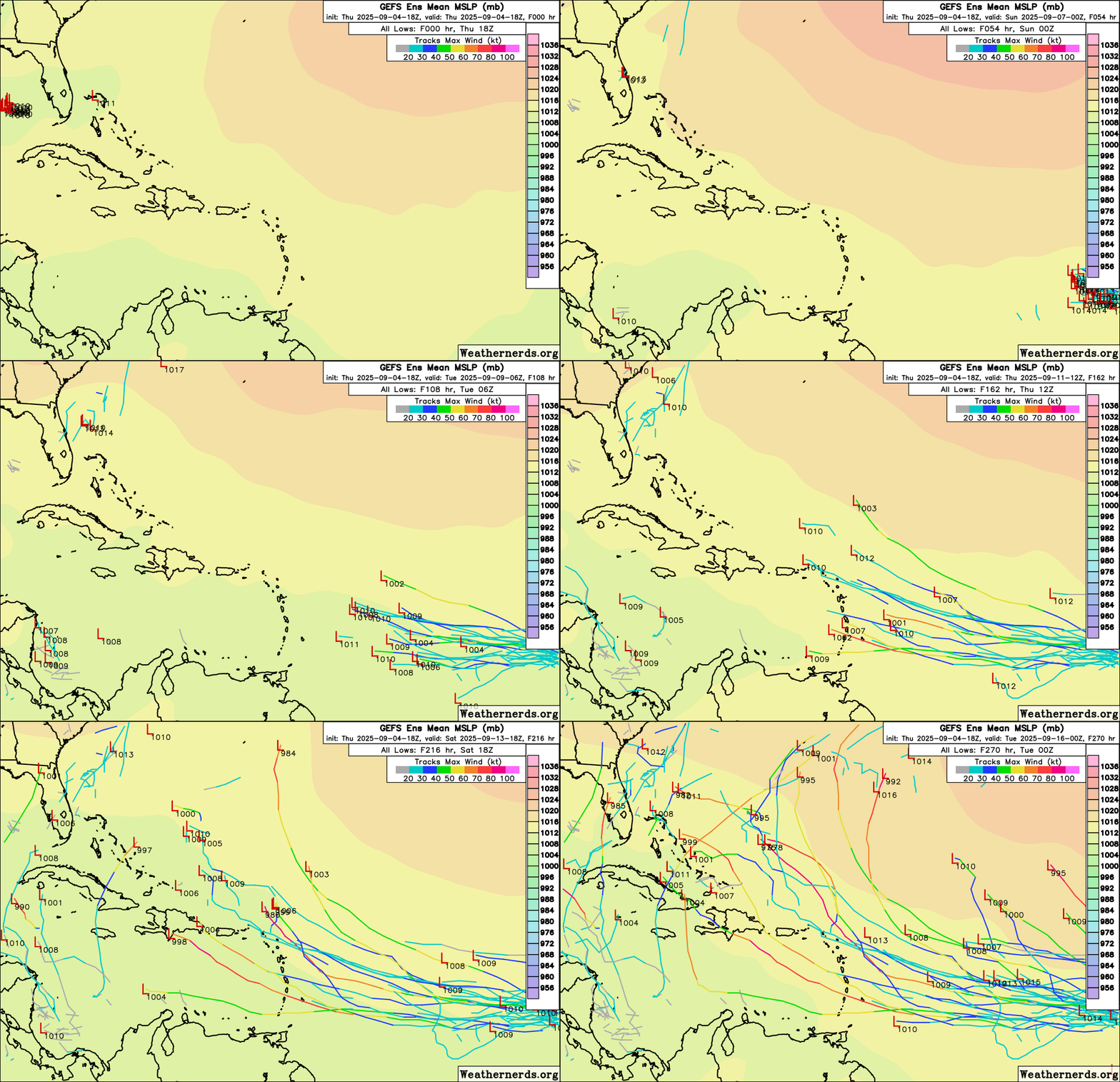
18z GEFS are not overly aggressive. They do, however, approach even further south across the Lesser Antilles through 180 hrs.
0 likes   

BobHarlem
Category 5
Category 5
Posts: 2412
Joined: Thu Oct 20, 2005 6:11 pm

Re: ATL: INVEST 91L - Models

#93 Postby BobHarlem » Thu Sep 04, 2025 6:49 pm

18z Euro, even weaker than the 12z.
Image
0 likes   

User avatar
chaser1
S2K Supporter
S2K Supporter
Posts: 5550
Age: 64
Joined: Sat Oct 15, 2005 5:59 pm
Location: Longwood, Fl

Re: ATL: INVEST 91L - Models

#94 Postby chaser1 » Thu Sep 04, 2025 6:56 pm

I wonder where the models will take 91L once initialized up around 14N? I'll say this much; Should that be verified at first light tomorrow morning (12Z), then I would suspect a quicker spin up to a T.D AND a pretty quick upgrade to T.S. The added couple of degrees distance between itself and the weak low to its southwest would probably mitigate low level convergence issues as well.
0 likes   
Andy D

(For official information, please refer to the NHC and NWS products.)

lsuhurricane
Category 1
Category 1
Posts: 269
Joined: Tue Aug 15, 2017 2:53 pm

Re: ATL: INVEST 91L - Models

#95 Postby lsuhurricane » Thu Sep 04, 2025 6:56 pm

Another comment on the 18z GEFS. Even members that do become strong and clip the Northern Lesser Antilles still have a difficult time recurving. They seem to stall and move westward towards the Bahamas. Clearly sensing high pressure building in after the ULL clears out.
0 likes   

IcyTundra
Category 5
Category 5
Posts: 1239
Joined: Mon Jun 07, 2021 9:32 pm
Location: Dickinson, Texas

Re: ATL: INVEST 91L - Models

#96 Postby IcyTundra » Thu Sep 04, 2025 7:19 pm

chaser1 wrote:I wonder where the models will take 91L once initialized up around 14N? I'll say this much; Should that be verified at first light tomorrow morning (12Z), then I would suspect a quicker spin up to a T.D AND a pretty quick upgrade to T.S. The added couple of degrees distance between itself and the weak low to its southwest would probably mitigate low level convergence issues as well.


I haven't looked at the satellite imagery today but I'm guessing that you have. Are you seeing something that makes you think that the models are intializing the center too far south?
0 likes   

User avatar
Teban54
Category 5
Category 5
Posts: 3314
Joined: Sat May 19, 2018 1:19 pm

Re: ATL: INVEST 91L - Models

#97 Postby Teban54 » Thu Sep 04, 2025 7:20 pm

Let me try to analyze why GFS did a complete 180, from a FL landfall at 12z to a recurve and Bermuda hit at 18z.

What happened on today's 18z run?

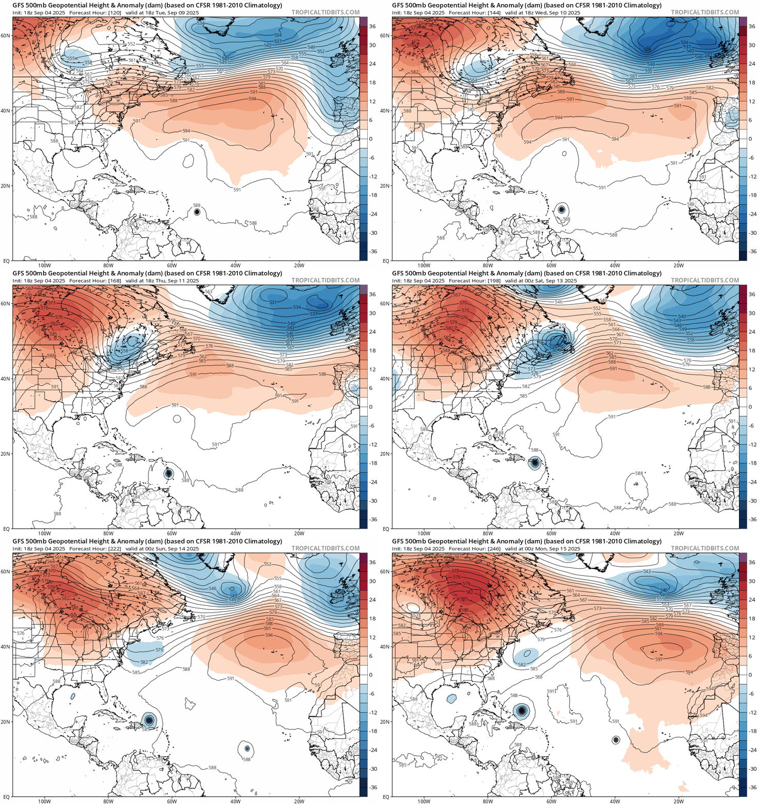
First, the run shows a trough coming down next week, making its closest approach to New England and Atlantic Canada on Friday 9/12. At this time, 91L is crossing into the Eastern Caribbean (landfall in Martinique) as a significant hurricane.

Even though the trough is too far north to pick up 91L, it leaves behind a cutoff low. In the last frame of the following loop, at 0z 9/15, the cutoff low is just east of Virginia. It has been around and eroded the ridge for long enough that 91L has made a very notable turn NW once past Lesser Antilles, and has now lifted to east of Bahamas.
Image

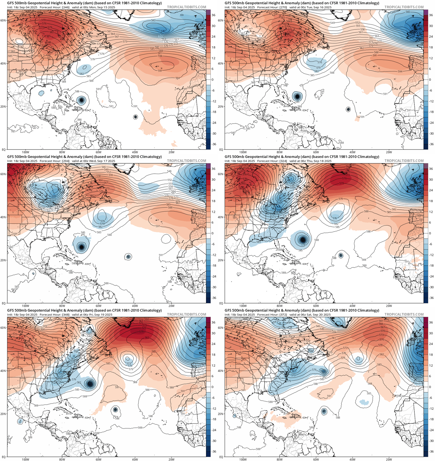
What happens afterwards is the interesting part. The cutoff low meanders along 40N and gradually moves east for 3-4 days, pulling 91L towards it ("recurving") very slowly. On 9/18, the cutoff low is still NE of 91L while a second trough is now to its NW. The complex upper-level pattern makes 91L move almost due north for a day while approaching Bermuda, before resuming a more conventional recurve pattern the next day (in tandem with the second trough).
Image

So three features played important roles in the evolution: The first trough (9/12), the cutoff low in the open Atlantic, and the second trough (9/18).

How confident are we with these features?

First trough: GFS has insisted on the 9/12 trough for the past 5-6 runs. ECMWF, on the other hand, only shows agreement in today's 12z run, but not the previous runs. CMC is inbetween. Regardless, the first trough itself isn't important (as it's too far north).

Atlantic cutoff low: It's the most crucial feature among the three -- but unfortunately, it's far from certain and very random.

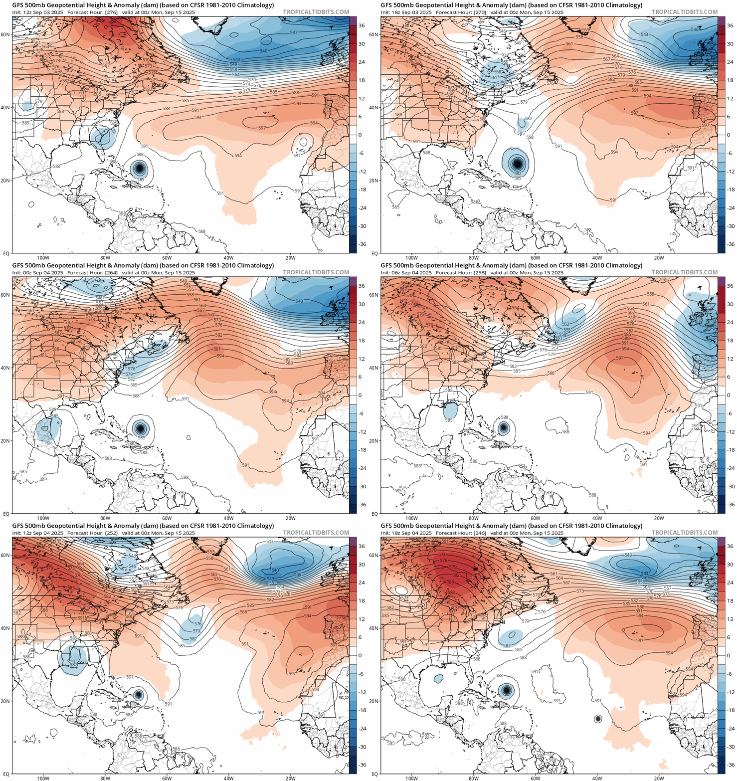
Remember the 0z 9/15 time stamp (246 hours out on the 18z)? Here's the trend for the past 6 runs:
Image

The GFS has remarkable consistency with 91L's location: east of the Bahamas. But the Atlantic low is everywhere. Sometimes it's non-existent, sometimes it's much further east at 50W, and sometimes there's even a second low in the Gulf!

  • 18z 9/4 (most recent)
    • 0z 9/15: Atlantic low east of VA; Gulf low very weak
    • Afterwards: Atlantic low slowly pulls 91L north, until the 9/18 trough tries to turn it but ultimately sends it OTS (past Bermuda)
  • 12z 9/4
    • 0z 9/15: Atlantic low south of Newfoundland; Gulf low moderately strong near AL
    • Afterwards: Ridge builds back, 91L moves WNW to FL, then pulled north by the Gulf low and brushes the East Coast
  • 6z 9/4
    • 0z 9/15: No Atlantic low; Gulf low weak and offshore FL Panhandle
    • Afterwards: 91L crosses through the Bahamas, interacts with Gulf low offshore FL, moves north and landfalls in SC
  • 0z 9/4
    • 0z 9/15: Atlantic low at New England-Nova Scotia and decaying; Gulf low in Mexico
    • Afterwards: Atlantic low is gone, but leaves a weakness long enough that 91L is still pulled north by it, and then OTS by the second trough
  • 18z 9/3
    • 0z 9/15: Atlantic low is quickly decaying, with some remnants near Bermuda and just north of 91L; no Gulf low
    • Afterwards: Ridge builds back quickly, 91L moves NW and brushes NC - New England

Not only are the strength, location and evolution of the Atlantic low very uncertain, but the possibility of a second Gulf low complicates things even further! For many East Coast states from FL to RI/MA, landfalls can occur in multiple scenarios depending on both lows (and a possible second trough).

Cross-checking with other models, 12z ECMWF has the cutoff low further east near Newfoundland, just like 12z GFS. Meanwhile, 12z CMC has the (very weak) Atlantic low all the way down to Florida, and 91L is already starting a turn NW (if not W) towards it at the end of the run.

IMO, this is nowhere close to "your typical mid-September with troughs everywhere". Betting on the Atlantic low lingering around for 3 days to save the day isn't very realistic.
7 likes   

User avatar
cycloneye
Admin
Admin
Posts: 146580
Age: 69
Joined: Thu Oct 10, 2002 10:54 am
Location: San Juan, Puerto Rico

Re: ATL: INVEST 91L - Models

#98 Postby cycloneye » Thu Sep 04, 2025 7:38 pm

Here are HWRF with a cat 3 while HAFS-A has almst nothing. The question is what does HWRF see very favorable while HAFS-A has it unfavorable?

Image

Image
0 likes   
Visit the Caribbean-Central America Weather Thread where you can find at first post web cams,radars
and observations from Caribbean basin members Click Here

BobHarlem
Category 5
Category 5
Posts: 2412
Joined: Thu Oct 20, 2005 6:11 pm

Re: ATL: INVEST 91L - Models

#99 Postby BobHarlem » Thu Sep 04, 2025 7:43 pm

18z GFS Ensembles plotted, half over the islands now, several go "poof", some curve west toward the end.
Image
0 likes   

User avatar
Teban54
Category 5
Category 5
Posts: 3314
Joined: Sat May 19, 2018 1:19 pm

Re: ATL: INVEST 91L - Models

#100 Postby Teban54 » Thu Sep 04, 2025 7:49 pm

cycloneye wrote:Here are HWRF with a cat 3 while HAFS-A has almst nothing. The question is what does HWRF see very favorable while HAFS-A has it unfavorable?

https://i.imgur.com/dSetyZQ.png

https://i.imgur.com/wY4qcOL.png

HMON, HAFS-A and HAFS-B all show a disorganized TD/TS or less. I can't recall the last time when even the CMC was more aggressive than the hurricane models.
1 likes   


Return to “2025”

Who is online

Users browsing this forum: No registered users and 34 guests