
Looks like this may pull in high-TPW air, from the EPAC, thru Panama into the Bahamas once it clears the Windward Passage.
https://tropic.ssec.wisc.edu/real-time/ ... anim=html5
NATL: IMELDA - Post-Tropical - Discussion
Moderator: S2k Moderators
Re: NATL: INVEST 94L - Discussion (70/90)
PTC advisories could happen later today just based on the Bahamas timing, although in a situation like this the forecast cone is going to be suspect.
1 likes
Re: NATL: INVEST 94L - Discussion (70/90)
I am not seeing much of a front to sweep this out to sea.
Not even close.
https://earth.nullschool.net/#2025/09/3 ... 328,35.321
Not even close.
https://earth.nullschool.net/#2025/09/3 ... 328,35.321
1 likes
Re: NATL: INVEST 94L - Discussion (70/90)
Persistent overshooting top about 60 nm south of LLC.
1 likes
-
Blown Away

- S2K Supporter

- Posts: 10253
- Joined: Wed May 26, 2004 6:17 am
Re: NATL: INVEST 94L - Discussion (70/90)
AL, 94, 2025092512, , BEST, 0, 200N, 707W, 25, 1011, DB,
0 likes
Hurricane Eye Experience: David 79, Irene 99, Frances 04, Jeanne 04, Wilma 05… Hurricane Brush Experience: Andrew 92, Erin 95, Floyd 99, Matthew 16, Irma 17, Ian 22, Nicole 22…
-
TampaWxLurker
- Tropical Storm

- Posts: 196
- Joined: Thu Aug 01, 2024 8:20 am
Re: NATL: INVEST 94L - Discussion (70/90)
Well...
If the models are to be believed...
The good news for the Carolinas is that 94L is going to have to compete with dry air entrainment and heavy shear during its trip north. So it shouldn't bomb out and rapidly intensify in a MH. Hopefully, anyways.
If the models are to be believed...
The good news for the Carolinas is that 94L is going to have to compete with dry air entrainment and heavy shear during its trip north. So it shouldn't bomb out and rapidly intensify in a MH. Hopefully, anyways.
1 likes
-
KeysRedWine
- Tropical Low

- Posts: 11
- Age: 42
- Joined: Thu Sep 19, 2024 12:30 pm
- Location: Summerland Key, FL
Re: NATL: INVEST 94L - Discussion (70/90)
Blown Away wrote:AL, 94, 2025092512, , BEST, 0, 200N, 707W, 25, 1011, DB,
There does seem to be a wind shift or wave axis on the north coast of DR. Recent dropsondes show SE winds east of that point, and ENE winds west of that. If a center develops up there this soon, it would be many hours ahead of the models.....
1 likes
Re: NATL: INVEST 94L - Discussion (70/90)
Looks like two LLCs
20N 71W (weak)
and
19N 71.5W.
https://rammb-data.cira.colostate.edu/t ... 0_swnd.gif
Convection is located closer to the southern.
I am going with that one.
20N 71W (weak)
and
19N 71.5W.
https://rammb-data.cira.colostate.edu/t ... 0_swnd.gif
Convection is located closer to the southern.
I am going with that one.
2 likes
-
OuterBanker
- S2K Supporter
- Posts: 1761
- Joined: Wed Feb 26, 2003 10:53 am
- Location: Nags Head, NC
- Contact:
Re: NATL: INVEST 94L - Discussion (70/90)
Quite possibly the longest long term discuss from nws I've ever seen locally (posted only what pertains to 94l and Humberto).
So many scenarios that are possible. Very rare.
Can I be excused, my brain is full.
So many scenarios that are possible. Very rare.
Can I be excused, my brain is full.
Sunday into midweek next week...Higher than avg uncertainty expected
in the forecast from Sun onwards given very complicated upper level
pattern around the Eastern Seaboard which leads into the big
question which is what will happen with Invest 94L and TS Humberto
early next week. Will go over the upper level pattern and
challenges and then potential solutions below.
Upper level cutoff low will meander around the Southeast and
Tennessee River Valley through early next week. Have followed recent
trends in the AI and ECWMF ensemble guidance which shows the upper
low pushing NE`wards early next week and exiting out to sea by
midweek as another trough dives SE`wards from the Canadian Maritimes
and provides an escape route for this upper low out ahead of an
upper level ridge to the west which will be approaching at the end
of the period. Key challenge here will be the eventual track of the
upper low as models notoriously have a hard time handling this type
of pattern and this low could have an impact on the eventual track
of Invest 94L. Otherwise temps stay about or just below avg through
the remainder of the long term given expected ample cloud cover and
widespread precip.
At the surface, stalled front remains over the coast through early
next week before dissipating keeping things unsettled through at
least Tue with daily chances for showers and storms across the
region. Strong high pressure ridging begins to build down across the
region as well on Tue/Wed from the north and west. At the same time
TS Humberto and Invest 94L look to be tracking NW to N on Sun and
Mon with Invest 94L potentially getting organized enough after it
departs Hispaniola earlier in the weekend to develop into a TD/TS
around the Bahamas. TS Humberto looks to continue off to the north
and eventually the NE closer to Bermuda as an upper trough leaves an
escape route for the system. The evolution of Invest 94L is where
the greatest uncertainty comes into play as multiple features will
play a role in the eventual track of the disturbance.
The first will be the speed in which Invest 94L develops. If the
system develops faster a quicker northward motion may occur with
greater impacts to the area, if slower development occurs more
interaction with TS Humberto is likely to occur limiting impacts
across ENC. The second will be the cutoff low in the Southeast which
if it moves far enough east could help to steer 94L closer to the
coast. Finally an incoming ridge of high pressure from the north
could block the escape route of both Humberto and 94L making the
forecast even more complicated. With this in mind and after taking a
look at the 00Z ensemble guidance it appears there will be three
possible solutions for early next week. The most likely as of right
now is that after 94L tracks across Hispaniola, it will gradually
develop on Mon/Tue into a TD/TS and begin interacting with TS
Humberto resulting in a rare phenomena called the Fujiwara effect.
With 94L likely being the weaker system at the time, TS Humberto
will flex its muscles on the disturbance creating an area of
enhanced wind shear over 94L keeping the system weak as well as
allowing 94L to attempt to circle around Humberto thus keeping both
systems out to sea and resulting in more indirect impacts to ENC.
The second solution which is currently less likely is that 94L
develops faster and the cut off low to its west is closer to the
coast allowing for less impact from Humberto and thus allowing for a
stronger system that moves more N/NW than NE and brings more direct
impacts to the area. Finally the least likely solution is that
Hispaniola disturbs the low level center of 94L enough to result in
no formation and TS Humberto remaining well out to sea. Given the
continued vast differences in the forecast make sure you continue to
stay weather aware this week and be on the lookout for further
updates.
6 likes

Re: NATL: INVEST 94L - Discussion (70/90)
Besides Erin, the 2025 season was pretty much nothing until a week ago. But it seems the basin feels like it has to compensate, because this is easily one of the most interesting, difficult and unfortunately most dangerous (due to uncertain intensity and the short time frame until a potential landfall) setups I've seen in quite a while. The fact that models range from a weak slop being pulled after Humberto to a MH threatening the Bahamas and the US in the 4 - 5 day range is quite extraordinary, but to be expected considering the tricky setup with Humberto and land interaction.
5 likes

Re: NATL: INVEST 94L - Discussion (70/90)
TampaWxLurker wrote:Well...
If the models are to be believed...
The good news for the Carolinas is that 94L is going to have to compete with dry air entrainment and heavy shear during its trip north. So it shouldn't bomb out and rapidly intensify in a MH. Hopefully, anyways.
Venting from the ULL and reduced storm relative shear if it’s trucking north rapidly could offset the limiting factors.
2 likes
Re: NATL: INVEST 94L - Discussion (70/90)
Surely we'll have a better idea this morning what's going to happen, it's in the 4-5 day range for landfall..
oh
oh
2 likes
-
wxman57

- Moderator-Pro Met

- Posts: 23175
- Age: 68
- Joined: Sat Jun 21, 2003 8:06 pm
- Location: Houston, TX (southwest)
Re: NATL: INVEST 94L - Discussion (70/90)
Major shift in models overnight - from a track out to sea to landfall in SC Monday. Issuing our first advisory now. Inland up the coast of CHS Monday afternoon as a 55kt TS. NHC should be starting advisories this morning, as TS warnings are needed for Bahamas with TS wind possible within 48 hrs.
6 likes
-
ScottNAtlanta

- Category 5

- Posts: 2535
- Joined: Sat May 25, 2013 3:11 pm
- Location: Atlanta, GA
Re: NATL: INVEST 94L - Discussion (70/90)
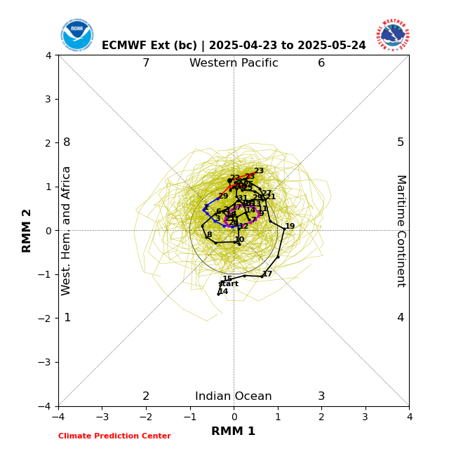
Have a look at the EMOM BC MJO Forecast. That side of the graph usually corresponds to US hits
1 likes
The posts in this forum are NOT official forecast and should not be used as such. They are just the opinion of the poster and may or may not be backed by sound meteorological data. They are NOT endorsed by any professional institution or storm2k.org. For official information, please refer to the NHC and NWS products.
Re: NATL: INVEST 94L - Discussion (70/90)
Looks like ole Jed tried to shoot a possum and up from the ground came a bubblin crude.
https://weather.cod.edu/satrad/?parms=s ... =undefined
https://weather.cod.edu/satrad/?parms=s ... =undefined
3 likes
Re: NATL: INVEST 94L - Discussion (70/90)
Drop 34: saturated boundary layer and above.
I am going with a TD before dusk.
https://www.tropicaltidbits.com/recon/r ... sondes.png
https://www.tropicaltidbits.com/recon/r ... 5-1324.png
I am going with a TD before dusk.
https://www.tropicaltidbits.com/recon/r ... sondes.png
https://www.tropicaltidbits.com/recon/r ... 5-1324.png
1 likes
Who is online
Users browsing this forum: No registered users and 83 guests