https://ftp.nhc.noaa.gov/atcf/btk/bal932025.dat
NATL: HUMBERTO - Remnants - Discussion
Moderator: S2k Moderators
- cycloneye
- Admin

- Posts: 149660
- Age: 69
- Joined: Thu Oct 10, 2002 10:54 am
- Location: San Juan, Puerto Rico
NATL: HUMBERTO - Remnants - Discussion
AL, 93, 2025092306, , BEST, 0, 142N, 476W, 20, 1011, DB, 34, NEQ, 0, 0, 0, 0, 1013, 150, 120, 0, 0, L, 0, , 0, 0, INVEST, S, 0, , 0, 0, 0, 0, genesis-num, 025, SPAWNINVEST, al762025 to al932025,
https://ftp.nhc.noaa.gov/atcf/btk/bal932025.dat
0 likes
Visit the Caribbean-Central America Weather Thread where you can find at first post web cams,radars
and observations from Caribbean basin members Click Here
and observations from Caribbean basin members Click Here
- cycloneye
- Admin

- Posts: 149660
- Age: 69
- Joined: Thu Oct 10, 2002 10:54 am
- Location: San Juan, Puerto Rico
Re: NATL: INVEST 93L - Discussion (50/90)
Central and Western Tropical Atlantic (AL93):
Shower and thunderstorm activity associated with a tropical wave
located a little less than 1000 miles east of the Lesser Antilles
continues to show signs of organization. Environmental conditions
are forecast to be favorable for development over the next several
days, and a tropical depression is likely to form by the latter half
of this week while the system moves west-northwestward to
northwestward into the western tropical Atlantic.
* Formation chance through 48 hours...medium...50 percent.
* Formation chance through 7 days...high...90 percent.
0 likes
Visit the Caribbean-Central America Weather Thread where you can find at first post web cams,radars
and observations from Caribbean basin members Click Here
and observations from Caribbean basin members Click Here
- cycloneye
- Admin

- Posts: 149660
- Age: 69
- Joined: Thu Oct 10, 2002 10:54 am
- Location: San Juan, Puerto Rico
Re: NATL: INVEST 93L - Discussion (50/90)
AL, 93, 2025092312, , BEST, 0, 150N, 480W, 20, 1011, DB
0 likes
Visit the Caribbean-Central America Weather Thread where you can find at first post web cams,radars
and observations from Caribbean basin members Click Here
and observations from Caribbean basin members Click Here
-
MEANINGLESS_NUMBERS
- Category 2

- Posts: 503
- Joined: Mon Nov 02, 2020 1:43 pm
Re: NATL: INVEST 93L - Discussion (50/90)
Convention decreasing this morning but there is good rotation.
0 likes
Emily '87, Felix '95, Gert '99, Fabian '03, Humberto '19, Paulette '20, Teddy '20, Fiona '22, Lee '23, Ernesto '24, Humberto/Imelda '25
- cycloneye
- Admin

- Posts: 149660
- Age: 69
- Joined: Thu Oct 10, 2002 10:54 am
- Location: San Juan, Puerto Rico
Re: NATL: INVEST 93L - Discussion (50/90)

4 likes
Visit the Caribbean-Central America Weather Thread where you can find at first post web cams,radars
and observations from Caribbean basin members Click Here
and observations from Caribbean basin members Click Here
- HurricaneAndre2008
- Category 1

- Posts: 356
- Age: 28
- Joined: Wed Jul 31, 2019 9:51 pm
- Contact:
Re: NATL: INVEST 93L - Discussion (50/90)
cycloneye wrote:https://i.imgur.com/2Wr8KWm.gif
This one may get going sooner than what we think.
4 likes
Cindy(2005), Katrina(2005), Rita(2005), Erin(2007), Isaac(2012)
Re: NATL: INVEST 93L - Discussion (50/90)
Looks like it's trying right now right around 15.5N and 47.8W under or just north of that new convection going off.
0 likes
Andy D
(For official information, please refer to the NHC and NWS products.)
(For official information, please refer to the NHC and NWS products.)
- cycloneye
- Admin

- Posts: 149660
- Age: 69
- Joined: Thu Oct 10, 2002 10:54 am
- Location: San Juan, Puerto Rico
Re: NATL: INVEST 93L - Discussion (60/90)
2 PM TWO:
Central and Western Tropical Atlantic (AL93):
Shower and thunderstorm activity associated with a tropical wave
located about 900 miles east of the Lesser Antilles continues to
show signs of organization. Environmental conditions are forecast
to be generally favorable for development, and a tropical
depression is likely to form during the next couple of days while
the system moves west-northwestward to northwestward into the
western tropical Atlantic.
* Formation chance through 48 hours...medium...60 percent.
* Formation chance through 7 days...high...90 percent.
0 likes
Visit the Caribbean-Central America Weather Thread where you can find at first post web cams,radars
and observations from Caribbean basin members Click Here
and observations from Caribbean basin members Click Here
- cycloneye
- Admin

- Posts: 149660
- Age: 69
- Joined: Thu Oct 10, 2002 10:54 am
- Location: San Juan, Puerto Rico
Re: NATL: INVEST 93L - Discussion (60/90)
18z Best Track:

AL, 93, 2025092318, , BEST, 0, 164N, 490W, 25, 1010, DB

0 likes
Visit the Caribbean-Central America Weather Thread where you can find at first post web cams,radars
and observations from Caribbean basin members Click Here
and observations from Caribbean basin members Click Here
Re: NATL: INVEST 93L - Discussion (60/90)
We're now hitting the 91L mark of 60/90!


5 likes
TC naming lists: retirements and intensity
Most aggressive Advisory #1's in North Atlantic (cr. kevin for starting the list)
Most aggressive Advisory #1's in North Atlantic (cr. kevin for starting the list)
- cycloneye
- Admin

- Posts: 149660
- Age: 69
- Joined: Thu Oct 10, 2002 10:54 am
- Location: San Juan, Puerto Rico
Re: NATL: INVEST 93L - Discussion (70/90)
8 PM TWO:
Central and Western Tropical Atlantic (AL93):
Shower and thunderstorm activity associated with a tropical wave
located about 750 miles east of the Leeward Islands has become
better organized since yesterday. Environmental conditions are
forecast to be favorable for further development, and a tropical
depression is likely to form during the next couple of days while
the system moves west-northwestward to northwestward into the
western tropical Atlantic, well north of the Leeward Islands.
* Formation chance through 48 hours...high...70 percent.
* Formation chance through 7 days...high...90 percent.
0 likes
Visit the Caribbean-Central America Weather Thread where you can find at first post web cams,radars
and observations from Caribbean basin members Click Here
and observations from Caribbean basin members Click Here
- AnnularCane
- S2K Supporter

- Posts: 2964
- Joined: Thu Jun 08, 2006 9:18 am
- Location: Wytheville, VA
Re: NATL: INVEST 93L - Discussion (60/90)
Teban54 wrote:We're now hitting the 91L mark of 60/90!
https://i.postimg.cc/VLbB2Xh4/goes19-truecolor-93-L-202509231615.gif
Slightly more at 70/90!
0 likes
"But it never rained rain. It never snowed snow. And it never blew just wind. It rained things like soup and juice. It snowed mashed potatoes and green peas. And sometimes the wind blew in storms of hamburgers." -- Judi Barrett, Cloudy with a Chance of Meatballs
Re: NATL: INVEST 93L - Discussion (70/90)
High pressure closes off the weakness after Gabrielle moves out.
And some models have this approaching 94L for a fujiwara dance.
The late developing waves were out there a week ago but there is too much confusion for the models.
And some models have this approaching 94L for a fujiwara dance.
The late developing waves were out there a week ago but there is too much confusion for the models.
0 likes
- cycloneye
- Admin

- Posts: 149660
- Age: 69
- Joined: Thu Oct 10, 2002 10:54 am
- Location: San Juan, Puerto Rico
Re: NATL: INVEST 93L - Discussion (70/90)
00z Best Track:
AL, 93, 2025092400, , BEST, 0, 172N, 502W, 25, 1010, DB
0 likes
Visit the Caribbean-Central America Weather Thread where you can find at first post web cams,radars
and observations from Caribbean basin members Click Here
and observations from Caribbean basin members Click Here
Re: NATL: INVEST 93L - Discussion (70/90)
If this continues developing quicker than 94L, is there any chance that affects its development (for better or worse)?
0 likes
- cycloneye
- Admin

- Posts: 149660
- Age: 69
- Joined: Thu Oct 10, 2002 10:54 am
- Location: San Juan, Puerto Rico
Re: NATL: INVEST 93L - Discussion (70/90)
Buck wrote:If this continues developing quicker than 94L, is there any chance that affects its development (for better or worse)?
A Fujiwhara between the two is a possibility as some models hint.
1 likes
Visit the Caribbean-Central America Weather Thread where you can find at first post web cams,radars
and observations from Caribbean basin members Click Here
and observations from Caribbean basin members Click Here
Re: NATL: INVEST 93L - Discussion (70/90)
cycloneye wrote:Buck wrote:If this continues developing quicker than 94L, is there any chance that affects its development (for better or worse)?
A Fujiwhara between the two is a possibility as some models hint.
Right, but are the close enough that outflow from one might inhibit development of the other? Doesn’t seem like it but the model spread is just so broad at the moment.
0 likes
Re: NATL: INVEST 93L - Discussion (70/90)
I hope this one gets the H
Last edited by Fancy1002 on Tue Sep 23, 2025 9:51 pm, edited 1 time in total.
0 likes
Re: NATL: INVEST 93L - Discussion (70/90)
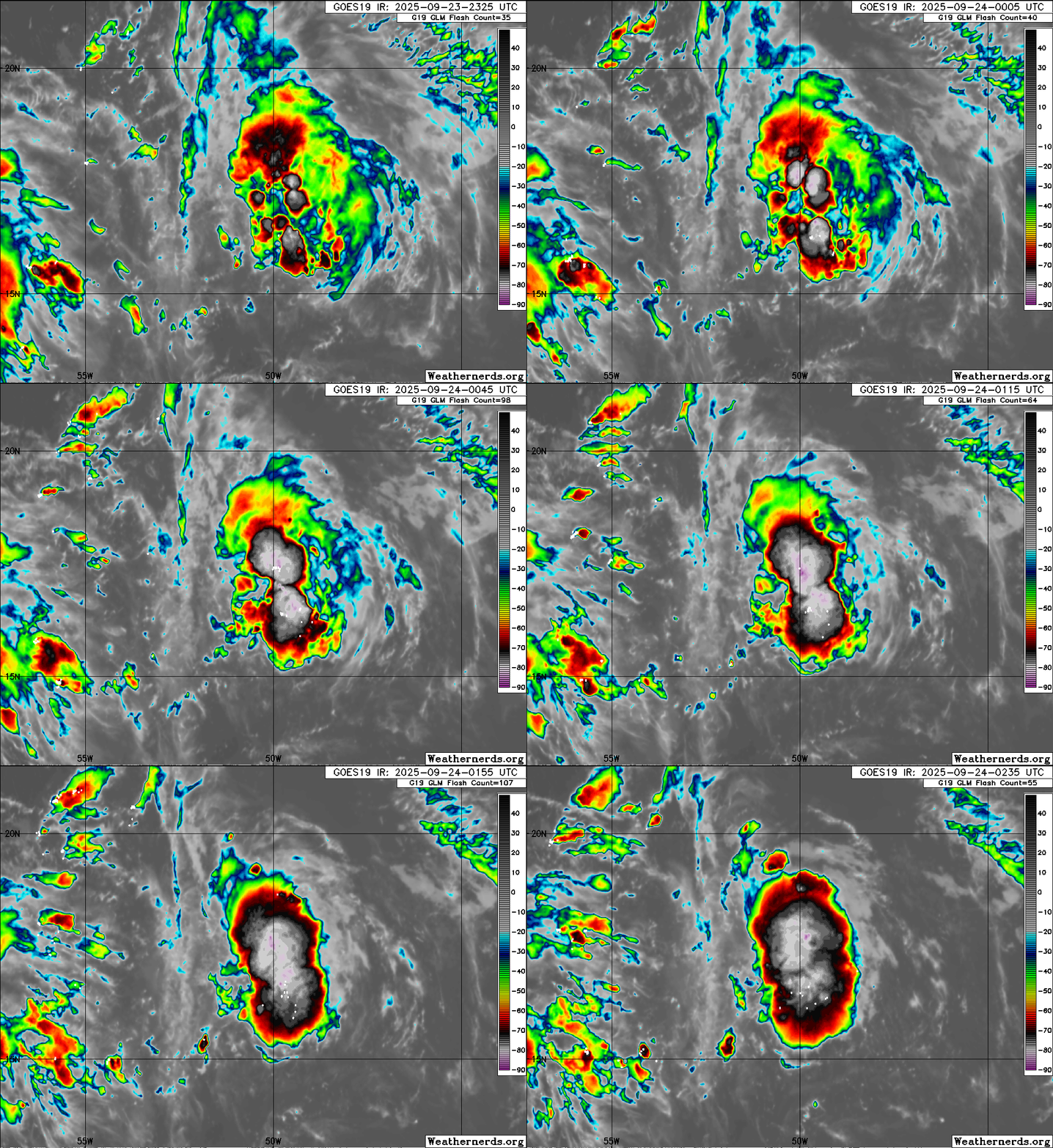
Very concentrated convection in recent frames. Will these hot towers be the final push towards genesis?


0 likes
TC naming lists: retirements and intensity
Most aggressive Advisory #1's in North Atlantic (cr. kevin for starting the list)
Most aggressive Advisory #1's in North Atlantic (cr. kevin for starting the list)
- cycloneye
- Admin

- Posts: 149660
- Age: 69
- Joined: Thu Oct 10, 2002 10:54 am
- Location: San Juan, Puerto Rico
Re: NATL: INVEST 93L - Discussion (80/90)
2 AM TWO:
Central and Western Tropical Atlantic (AL93):
Shower and thunderstorm activity associated with a tropical wave
located about 700 miles east of the Leeward Islands continues to
show signs of organization. Environmental conditions are forecast
to be favorable for further development, and a tropical depression
is likely to form during the next couple of days while the system
moves west-northwestward to northwestward into the western tropical
Atlantic, well north of the Leeward Islands.
* Formation chance through 48 hours...high...80 percent.
* Formation chance through 7 days...high...90 percent.
0 likes
Visit the Caribbean-Central America Weather Thread where you can find at first post web cams,radars
and observations from Caribbean basin members Click Here
and observations from Caribbean basin members Click Here
Who is online
Users browsing this forum: No registered users and 48 guests


