NATL: HUMBERTO - Models
Moderator: S2k Moderators
-
MEANINGLESS_NUMBERS
- Category 2

- Posts: 503
- Joined: Mon Nov 02, 2020 1:43 pm
NATL: HUMBERTO - Models
This is the more easterly red (50/90) area. The models that develop it (all except GFS) recurve near Bermuda around 144-168 hours.
0 likes
Emily '87, Felix '95, Gert '99, Fabian '03, Humberto '19, Paulette '20, Teddy '20, Fiona '22, Lee '23, Ernesto '24, Humberto/Imelda '25

Re: NATL: INVEST 93L - Models
Not quite all -- the 6z Euro AI hit the NC coast with this system.
0 likes

Re: NATL: INVEST 93L - Models
This is a tricky forecast - you have the interaction of these two invests, plus the remnants of a front that will move through the mid-Atlantic on Friday.
The GFS develops the trailing wave. The Euro seems to favor the leading wave. And Icon has both doing about equally as well.
The GFS develops the trailing wave. The Euro seems to favor the leading wave. And Icon has both doing about equally as well.
2 likes
-
cycloneye

- Admin

- Posts: 149829
- Age: 69
- Joined: Thu Oct 10, 2002 10:54 am
- Location: San Juan, Puerto Rico
Re: NATL: INVEST 93L - Models
12z GFS has 93L as the dominant system.

0 likes
Visit the Caribbean-Central America Weather Thread where you can find at first post web cams,radars
and observations from Caribbean basin members Click Here
and observations from Caribbean basin members Click Here


Re: NATL: INVEST 93L - Models
12z ICON with the Bermuda double MH whammy.
1 likes
Igor 2010, Sandy 2012, Fay 2014, Gonzalo 2014, Joaquin 2015, Nicole 2016, Humberto 2019, Imelda 2025
I am only a tropical weather enthusiast. My predictions are not official and may or may not be backed by sound meteorological data. For official information, please refer to the NHC and NWS products.
I am only a tropical weather enthusiast. My predictions are not official and may or may not be backed by sound meteorological data. For official information, please refer to the NHC and NWS products.
-
MEANINGLESS_NUMBERS
- Category 2
- Posts: 503
- Joined: Mon Nov 02, 2020 1:43 pm
Re: NATL: INVEST 93L - Models
Kazmit wrote:12z ICON with the Bermuda double MH whammy.
12z CMC with double Cat 1-2s. Really complex situation if they both develop. Forecasters will earn their keep, that's for sure.
2 likes
Emily '87, Felix '95, Gert '99, Fabian '03, Humberto '19, Paulette '20, Teddy '20, Fiona '22, Lee '23, Ernesto '24, Humberto/Imelda '25

Re: NATL: INVEST 93L - Models
MEANINGLESS_NUMBERS wrote:Kazmit wrote:12z ICON with the Bermuda double MH whammy.
12z CMC with double Cat 1-2s. Really complex situation if they both develop. Forecasters will earn their keep, that's for sure.
And now 12z ECMWF is also onboard with double MHs... That escalated quickly within a single model cycle.
4 likes
TC naming lists: retirements and intensity
Most aggressive Advisory #1's in North Atlantic (cr. kevin for starting the list)
Most aggressive Advisory #1's in North Atlantic (cr. kevin for starting the list)


Re: NATL: INVEST 93L - Models
Wow, yeah  That 12Z EURO is wild to look at! Even weirder to contemplate in a scenario where steering temporarily breaks down
4 likes
Andy D
(For official information, please refer to the NHC and NWS products.)
(For official information, please refer to the NHC and NWS products.)
Re: NATL: INVEST 93L - Models
The GFS has 93L and 94L developing and moving almost in lockstep with each other. Extremely unusual setup. They don't seem to affect each other much at all.
4 likes
-
cycloneye
- Admin
- Posts: 149829
- Age: 69
- Joined: Thu Oct 10, 2002 10:54 am
- Location: San Juan, Puerto Rico
Re: NATL: INVEST 93L - Models
I didn't know where to post this as Maue talks about both invests, but decided to post here. 
https://x.com/RyanMaue/status/1970641972143530251
https://x.com/RyanMaue/status/1970641972143530251
0 likes
Visit the Caribbean-Central America Weather Thread where you can find at first post web cams,radars
and observations from Caribbean basin members Click Here
and observations from Caribbean basin members Click Here

Re: NATL: INVEST 93L - Models
Quoting what I just posted in the 94L model thread:
Teban54 wrote:A surprising number of operational models are now not just developing both 93L and 94L, but having both grow into significant hurricanes - and often, extremely close to each other. This trend started at 12z today and continued into 18z.
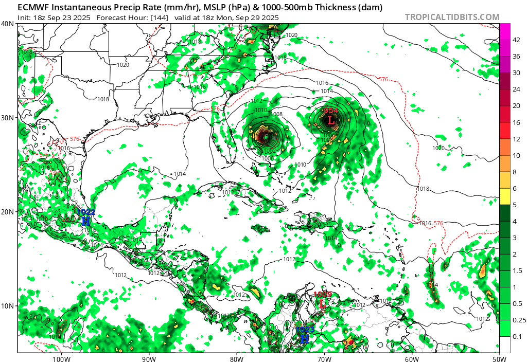
18z ECMWF. This is the end of the run, and both storms are stronger than 12z.
https://i.postimg.cc/fRzK8skZ/ecmwf-mslp-pcpn-watl-48.png
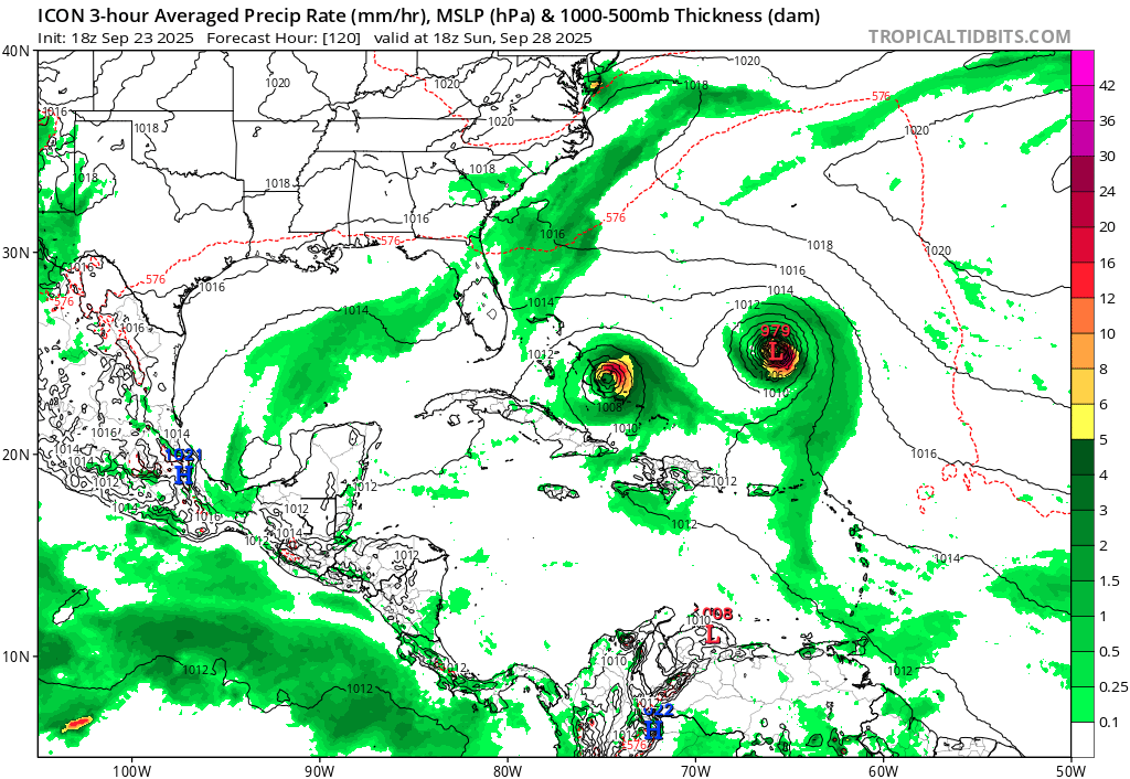
18z ICON. Compared to the 12z run, 93L's intensity is about the same, and 94L is only a tad weaker.
https://i.postimg.cc/gjpRryZd/icon-mslp-pcpn-watl-40.png
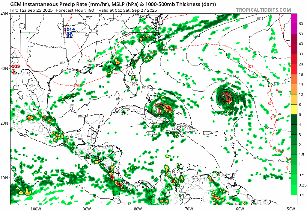
12z CMC, showing a loop with the peaks of both storms.
https://i.postimg.cc/MGypHCbM/gem-mslp-pcpn-watl-fh90-240.gif
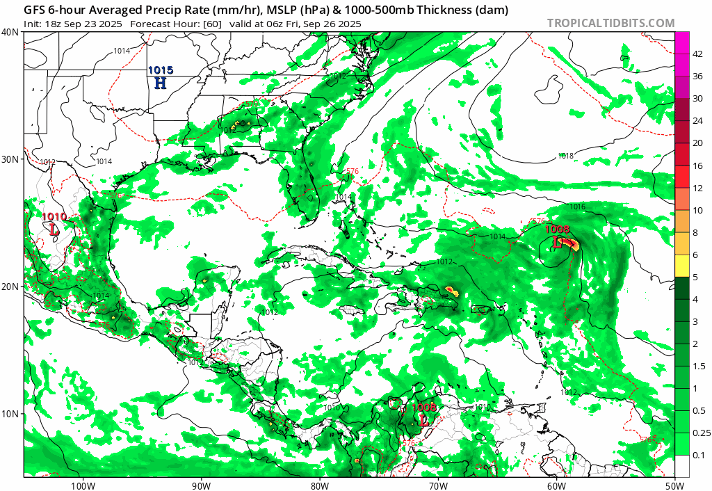
18z GFS. While much weaker in intensity, the GFS has never really been enthusiastic with either 93L or 94L becoming strong hurricanes. This is also the first GFS run clearly showing both co-existing as TCs. You can argue that it's playing catchup.
https://i.postimg.cc/dQWthmdB/gfs-mslp-pcpn-watl-fh60-168.gif
Does that give us any certainty? No.
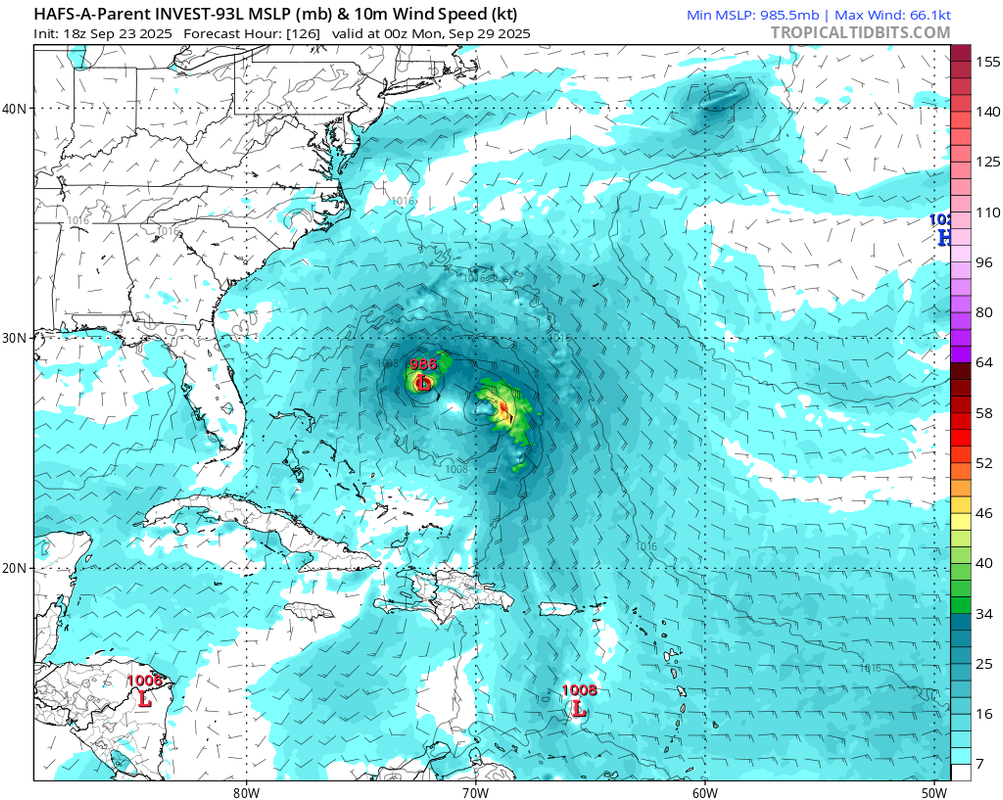
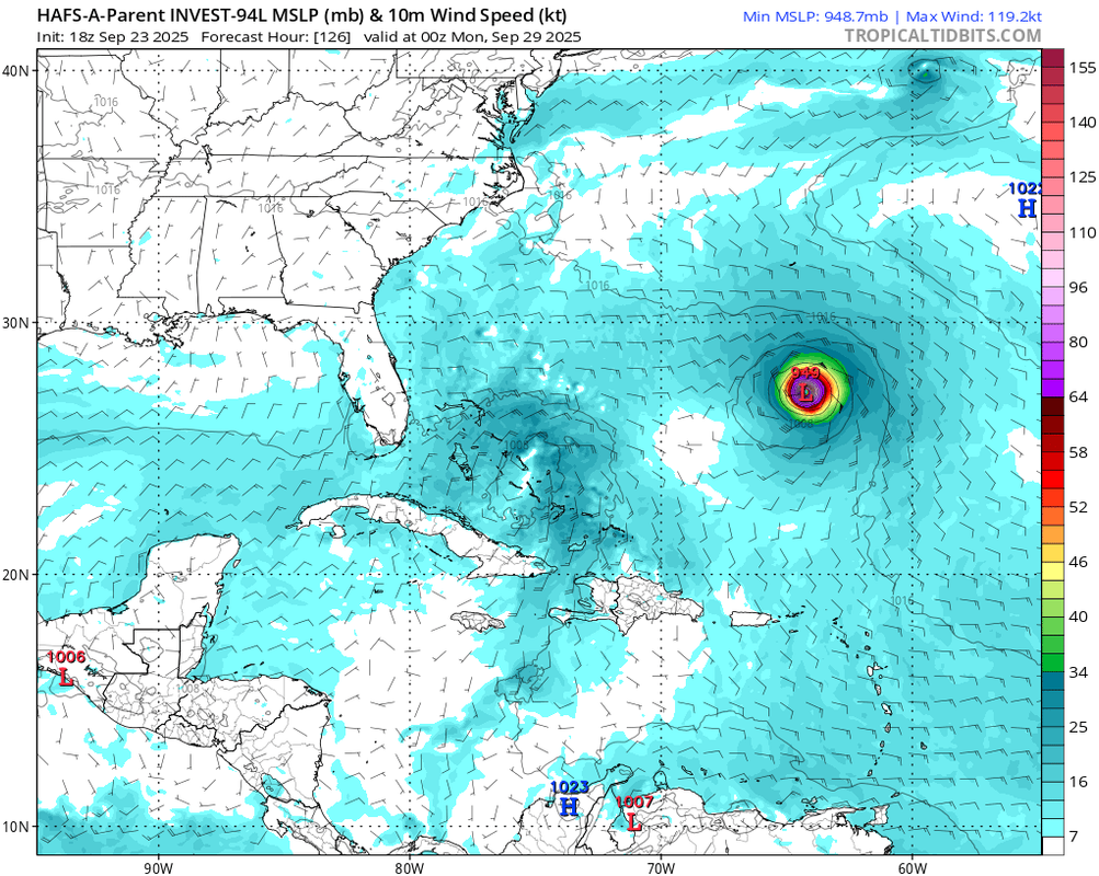
Look no further than 18z HAFS-A Parent: Same model, same init time, just initialized on the two different systems.
18z HAFS-A Parent for 93L: A full Fujiwhara between the two storms, neither of which getting beyond a minimal hurricane at most.
https://i.postimg.cc/13TZSJkg/hafsa-p-mslp-wind-93-L-43.png
18z HAFS-A Parent for 94L: The "other" storm, 93L, cleanly separates and bombs out. Meanwhile, 94L's vorticity crosses through the Greater Antilles, and slowly organizes from a broad, weak low at the end of the run.
https://i.postimg.cc/rmG6ScKW/hafsa-p-mslp-wind-94-L-43.png
The hurricanes models in general are much less enthusiastic on intensification - or development at all - than the global models.
I don't know why there's such a difference. Perhaps the hurricane models are designed for forecasting a single storm, and struggles with interactions of multiple systems?
0 likes
TC naming lists: retirements and intensity
Most aggressive Advisory #1's in North Atlantic (cr. kevin for starting the list)
Most aggressive Advisory #1's in North Atlantic (cr. kevin for starting the list)

Re: NATL: INVEST 93L - Models
00z Euro already shows a closed 30 kt TD (1011 mb) at +30 hr. Becomes a TS at +48 hr, a hurricane at +78 hr and then a MH around +126 hr based on the pressure. Peaks at 958 mb and recurves west of Bermuda.
0 likes
-
cycloneye
- Admin
- Posts: 149829
- Age: 69
- Joined: Thu Oct 10, 2002 10:54 am
- Location: San Juan, Puerto Rico
Re: NATL: INVEST 93L - Models
06z GFS has this invest as the dominant one.

0 likes
Visit the Caribbean-Central America Weather Thread where you can find at first post web cams,radars
and observations from Caribbean basin members Click Here
and observations from Caribbean basin members Click Here
-
cycloneye
- Admin
- Posts: 149829
- Age: 69
- Joined: Thu Oct 10, 2002 10:54 am
- Location: San Juan, Puerto Rico
Re: NATL: INVEST 93L - Models
Is becoming more consistent the dominance of 93L in the models. 06z Euro shows it.

0 likes
Visit the Caribbean-Central America Weather Thread where you can find at first post web cams,radars
and observations from Caribbean basin members Click Here
and observations from Caribbean basin members Click Here
Re: NATL: INVEST 93L - Models
12z ICON shows both systems within 90 hours (93L forming at +39hr and 94L at +66hr). 93L is clearly the stronger system, at least in the short-term. Also note Gabrielle near Portugal.

0 likes
Re: NATL: INVEST 93L - Models
Welp, 12z ICON goes all in... two MH it is. Also posted this in the 94L models thread, but it's also very relevant here. 93L passes just west of Bermuda (but still close enough for at the very least TS sustained winds) at +168hr with a pressure of 938 mb.

1 likes
Re: NATL: INVEST 93L - Models
GFS is catching up with 93L's short-term organization and dominance over 94L, more in line with what other models have been doing for days.
Its 12z run has 972 mb just 78 hours from now. Trend:
Its 12z run has 972 mb just 78 hours from now. Trend:
0 likes
TC naming lists: retirements and intensity
Most aggressive Advisory #1's in North Atlantic (cr. kevin for starting the list)
Most aggressive Advisory #1's in North Atlantic (cr. kevin for starting the list)
Re: NATL: INVEST 93L - Models
12Z UK just W of Bermuda
TROPICAL DEPRESSION 93L ANALYSED POSITION : 19.7N 53.9W
ATCF IDENTIFIER : AL932025
LEAD CENTRAL MAXIMUM WIND
VERIFYING TIME TIME POSITION PRESSURE (MB) SPEED (KNOTS)
-------------- ---- -------- ------------- -------------
1200UTC 24.09.2025 0 19.7N 53.9W 1014 33
0000UTC 25.09.2025 12 20.6N 56.0W 1013 32
1200UTC 25.09.2025 24 21.3N 57.4W 1012 33
0000UTC 26.09.2025 36 21.7N 57.9W 1009 34
1200UTC 26.09.2025 48 21.7N 58.5W 1007 35
0000UTC 27.09.2025 60 22.0N 59.1W 1005 42
1200UTC 27.09.2025 72 22.0N 60.3W 1003 44
0000UTC 28.09.2025 84 22.2N 61.0W 1000 44
1200UTC 28.09.2025 96 22.8N 63.0W 998 47
0000UTC 29.09.2025 108 23.7N 64.5W 994 49
1200UTC 29.09.2025 120 24.5N 66.3W 992 52
0000UTC 30.09.2025 132 25.6N 67.8W 991 56
1200UTC 30.09.2025 144 27.3N 68.4W 991 54
0000UTC 01.10.2025 156 29.1N 67.8W 984 59
1200UTC 01.10.2025 168 31.9N 66.6W 972 61
0 likes
Personal Forecast Disclaimer:
The posts in this forum are NOT official forecasts and should not be used as such. They are just the opinion of the poster and may or may not be backed by sound meteorological data. They are NOT endorsed by any professional institution or storm2k.org. For official information, please refer to the NHC and NWS products.
The posts in this forum are NOT official forecasts and should not be used as such. They are just the opinion of the poster and may or may not be backed by sound meteorological data. They are NOT endorsed by any professional institution or storm2k.org. For official information, please refer to the NHC and NWS products.
-
cycloneye
- Admin
- Posts: 149829
- Age: 69
- Joined: Thu Oct 10, 2002 10:54 am
- Location: San Juan, Puerto Rico
Re: NATL: HUMBERTO - Models
HMON blowsup to cat 4.

1 likes
Visit the Caribbean-Central America Weather Thread where you can find at first post web cams,radars
and observations from Caribbean basin members Click Here
and observations from Caribbean basin members Click Here
Who is online
Users browsing this forum: No registered users and 36 guests