
[/img]http://www.ssd.noaa.gov/PS/TROP/DATA/RT/FLOAT2/IR4/20.jpg[img]
Where is the center here?[/img]
Invest 95L,Comments,Sat Pics,Models Thread
Moderator: S2k Moderators
Forum rules

The posts in this forum are NOT official forecasts and should not be used as such. They are just the opinion of the poster and may or may not be backed by sound meteorological data. They are NOT endorsed by any professional institution or STORM2K. For official information, please refer to products from the National Hurricane Center and National Weather Service.

-
cycloneye

- Admin

- Posts: 148821
- Age: 69
- Joined: Thu Oct 10, 2002 10:54 am
- Location: San Juan, Puerto Rico
A TROPICAL DISTURBANCE...1009 MB LOW...IS CENTERED ABOUT 400 NM
ESE OF BARBADOS NEAR 11.5N53W MOVING WNW 10-15 KT...ALONG THE
TROPICAL WAVE NEAR 52W/53W. VISIBLE IMAGERY INDICATES THAT THE
CIRCULATION AROUND THE SURFACE LOW IS BECOMING MORE CONSOLIDATED
AND IS ISOLATING ITSELF FROM THE ITCZ AXIS AND A SEPARATE SWIRL
ABOUT 400 NM TO THE N. THE SYSTEM IS EMBEDDED IN A BROAD
DIFFLUENT UPPER LEVEL ENVIRONMENT AND THESE CONDITIONS ARE
EXPECTED TO PERSIST FOR THE NEXT SEVERAL DAYS. TROPICAL CYCLONE
DEVELOPMENT IS POSSIBLE JUST E OF THE LESSER ANTILLES WITHIN THE
NEXT 36 HRS...WITH HEAVY SHOWERS/TSTMS EXPECTED TO SPREAD OVER
THE ISLANDS LATER ON SAT AND SUN. NUMEROUS MODERATE/ISOLATED
STRONG CONVECTION FROM 10N-13N BETWEEN 47W-56W.
8 PM Discussion.
0 likes
Visit the Caribbean-Central America Weather Thread where you can find at first post web cams,radars
and observations from Caribbean basin members Click Here
and observations from Caribbean basin members Click Here
-
cycloneye
- Admin
- Posts: 148821
- Age: 69
- Joined: Thu Oct 10, 2002 10:54 am
- Location: San Juan, Puerto Rico
TROPICAL DEPRESSION INVEST (AL952005) ON 20050917 0000 UTC
...00 HRS... ...12 HRS... ...24 HRS... ...36 HRS...
050917 0000 050917 1200 050918 0000 050918 1200
LAT LON LAT LON LAT LON LAT LON
BAMD 11.8N 53.4W 12.6N 54.7W 13.4N 55.7W 14.2N 56.5W
BAMM 11.8N 53.4W 12.7N 54.7W 13.5N 55.6W 14.3N 56.4W
A98E 11.8N 53.4W 12.8N 55.1W 13.7N 56.7W 14.5N 58.0W
LBAR 11.8N 53.4W 12.8N 55.1W 13.6N 56.9W 14.3N 58.5W
SHIP 25KTS 33KTS 43KTS 54KTS
DSHP 25KTS 33KTS 43KTS 54KTS
...48 HRS... ...72 HRS... ...96 HRS... ..120 HRS...
050919 0000 050920 0000 050921 0000 050922 0000
LAT LON LAT LON LAT LON LAT LON
BAMD 15.0N 57.1W 16.8N 58.1W 18.9N 58.9W 21.1N 59.4W
BAMM 15.1N 57.0W 16.4N 58.0W 18.0N 59.2W 19.7N 60.0W
A98E 15.4N 59.1W 17.7N 61.2W 19.9N 63.1W 22.5N 63.9W
LBAR 14.9N 60.1W 16.1N 63.2W 17.8N 65.7W 21.0N 66.6W
SHIP 65KTS 79KTS 87KTS 92KTS
DSHP 65KTS 79KTS 87KTS 92KTS
...INITIAL CONDITIONS...
LATCUR = 11.8N LONCUR = 53.4W DIRCUR = 305DEG SPDCUR = 10KT
LATM12 = 10.6N LONM12 = 51.7W DIRM12 = 307DEG SPDM12 = 10KT
LATM24 = 9.6N LONM24 = 50.0W
WNDCUR = 25KT RMAXWD = 30NM WNDM12 = 25KT
CENPRS = 1009MB OUTPRS = 1012MB OUTRAD = 150NM SDEPTH = D
RD34NE = 0NM RD34SE = 0NM RD34SW = 0NM RD34NW = 0NM
00:00z Tropical Models.
0 likes
Visit the Caribbean-Central America Weather Thread where you can find at first post web cams,radars
and observations from Caribbean basin members Click Here
and observations from Caribbean basin members Click Here


-
Windtalker1

- S2K Supporter

- Posts: 523
- Age: 37
- Joined: Sun Jul 31, 2005 11:00 am
- Location: Mesa, Arizona
Maybe not Fish.....
Isn't the High suspose to build back and push this more west once she or he passes 22N?
0 likes
-
Charles-KD5ZSM
- Tropical Depression

- Posts: 62
- Joined: Fri Aug 26, 2005 5:09 pm
- Location: Ocean Springs, MS
-
Windtalker1
- S2K Supporter
- Posts: 523
- Age: 37
- Joined: Sun Jul 31, 2005 11:00 am
- Location: Mesa, Arizona
-
SeaBrz_FL

- S2K Supporter
- Posts: 472
- Age: 70
- Joined: Thu Aug 12, 2004 10:47 am
- Location: Cape Canaveral, FL
No fish for me! Leaving on a cruise out of Pt Canaveral tomorrow heading for Nassau then St Thomas and St Marteen.
I know, I can hear you all saying ..."who in their right mind would book a Caribbean cruise in September??!!" I like the cheap prices and lack of kids on Sept cruises, but looks like my luck may have run out.
I know, I can hear you all saying ..."who in their right mind would book a Caribbean cruise in September??!!" I like the cheap prices and lack of kids on Sept cruises, but looks like my luck may have run out.
0 likes
This is not a forecast-just my simple analysis.
http://www.ssd.noaa.gov/PS/TROP/DATA/RT ... -loop.html
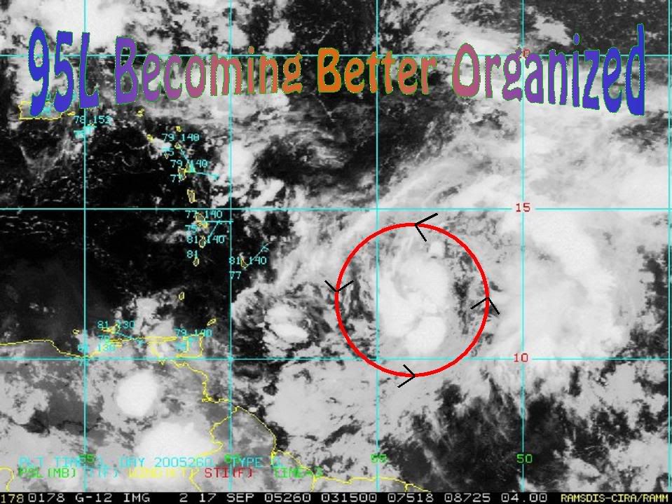
Shortwave imagery shows good organization taking place. The convection may not be as deep as earlier today...but is more concentrated near the center. Some weak banding also noted...it was easily seen earlier on visable imagery. You can also see in satellite imagery how the system is becoming detached from the wave itself...another indicator of development.
The only thing that can hold up development is the shear that is currently just north and west of the system. If it doesn't develop during the next 24 hours then it will probably have to wait until it gets north of the islands...or there about.
Looking down the road...model guidance builds the ridge back in after day 5. This means a possible W or WNW track thereafter. Keep in mind this is based on the consensus of global model data.
Historically systems that make it north of the islands this time of year recurve around 65W, 70W or 75W. We shall see.
http://www.ssd.noaa.gov/PS/TROP/DATA/RT ... -loop.html
Shortwave imagery shows good organization taking place. The convection may not be as deep as earlier today...but is more concentrated near the center. Some weak banding also noted...it was easily seen earlier on visable imagery. You can also see in satellite imagery how the system is becoming detached from the wave itself...another indicator of development.
The only thing that can hold up development is the shear that is currently just north and west of the system. If it doesn't develop during the next 24 hours then it will probably have to wait until it gets north of the islands...or there about.
Looking down the road...model guidance builds the ridge back in after day 5. This means a possible W or WNW track thereafter. Keep in mind this is based on the consensus of global model data.
Historically systems that make it north of the islands this time of year recurve around 65W, 70W or 75W. We shall see.
0 likes
-
Brent
- S2K Supporter
- Posts: 38590
- Age: 37
- Joined: Sun May 16, 2004 10:30 pm
- Location: Tulsa Oklahoma
- Contact:
10:30pm TWO:
THE VIGOROUS TROPICAL WAVE LOCATED ABOUT 400 MILES EAST OF THE
WINDWARD ISLANDS HAS CHANGED LITTLE THIS EVENING. HOWEVER...
UPPER-LEVEL WINDS HAVE CONTINUED TO BECOME MORE FAVORABLE...AND A
TROPICAL DEPRESSION COULD FORM ON SATURDAY AS THE SYSTEM MOVES
WEST-NORTHWESTWARD AT AROUND 10 TO 15 MPH. INTERESTS IN THE LESSER
ANTILLES AND THE EASTERN CARIBBEAN SEA SHOULD CLOSELY MONITOR THIS
SYSTEM OVER THE NEXT COUPLE OF DAYS. AN AIR FORCE RESERVE UNIT
RECONNAISSANCE AIRCRAFT IS SCHEDULED TO INVESTIGATE THE SYSTEM
SATURDAY AFTERNOON...IF NECESSARY.
0 likes
#neversummer


Who is online
Users browsing this forum: No registered users and 81 guests