TD 24,Comments,Sat Pics,Models Thread

This is the general tropical discussion area. Anyone can take their shot at predicting a storms path.

Moderator: S2k Moderators

Forum rules

The posts in this forum are NOT official forecasts and should not be used as such. They are just the opinion of the poster and may or may not be backed by sound meteorological data. They are NOT endorsed by any professional institution or STORM2K. For official information, please refer to products from the National Hurricane Center and National Weather Service.

Help Support Storm2K
Message
Author
rockyman
Category 5
Category 5
Posts: 1967
Joined: Thu Jun 26, 2003 12:24 pm
Location: Dauphin Island, AL

#321 Postby rockyman » Sun Oct 16, 2005 7:19 am

cycloneye wrote:CHGQLM
ATTENTION...NATIONAL HURRICANE CENTER

NCEP COUPLED GFDL HURRICANE MODEL FORECAST MADE FOR

TROPICAL DEPRESSION TWENTY-FO 24L

INITIAL TIME 6Z OCT 16

DISCLAIMER ... THIS INFORMATION IS PROVIDED AS GUIDANCE. IT
REQUIRES INTERPRETATION BY HURRICANE SPECIALISTS AND SHOULD
NOT BE CONSIDERED AS A FINAL PRODUCT. PLEASE SEE THE TPC/NHC
OFFICIAL FORECAST.


FORECAST STORM POSITION

HOUR LATITUDE LONGITUDE HEADING/SPEED(KT)

0 17.0 79.3 250./ 2.9
6 17.0 79.4 312./ 1.2
12 16.9 79.4 188./ 1.4
18 16.9 79.2 82./ 1.4
24 17.0 79.2 51./ .6
30 17.1 79.3 336./ 1.7
36 17.5 79.3 350./ 3.5
42 17.8 79.6 315./ 4.3
48 18.1 80.0 308./ 4.7
54 18.2 80.6 285./ 6.0
60 18.5 81.0 301./ 4.3
66 18.5 81.4 279./ 3.6
72 18.8 81.7 308./ 4.4
78 19.3 82.1 321./ 5.5
84 19.7 82.5 317./ 5.8
90 20.2 82.8 330./ 5.7
96 20.7 83.1 329./ 5.3
102 21.4 83.4 336./ 7.9
108 22.2 83.7 342./ 9.0
114 23.3 83.8 351./10.5
120 24.4 84.2 342./11.2
126 25.5 84.1 4./11.8


6z GFDL.Anyone has the graphic for this GFDL run?


Hey, Luis...here 'tis (pink line):

Image
0 likes   

User avatar
cycloneye
Admin
Admin
Posts: 145867
Age: 69
Joined: Thu Oct 10, 2002 10:54 am
Location: San Juan, Puerto Rico

#322 Postby cycloneye » Sun Oct 16, 2005 7:21 am

16/1145 UTC 17.1N 79.2W T2.5/2.5 24 -- Atlantic Ocean


2.5 dvorak sat estimates means 35 kts but not necessary NHC follows this as Stacey Stewart said in discussion about this but it has been two times in a row that 2.5 appears.
0 likes   
Visit the Caribbean-Central America Weather Thread where you can find at first post web cams,radars
and observations from Caribbean basin members Click Here

User avatar
cycloneye
Admin
Admin
Posts: 145867
Age: 69
Joined: Thu Oct 10, 2002 10:54 am
Location: San Juan, Puerto Rico

#323 Postby cycloneye » Sun Oct 16, 2005 7:23 am

No rockyman thank you for that one what I want is the one graphic for GFDL only that shows the intensity pressure.
0 likes   
Visit the Caribbean-Central America Weather Thread where you can find at first post web cams,radars
and observations from Caribbean basin members Click Here

User avatar
senorpepr
Military Met/Moderator
Posts: 12542
Age: 43
Joined: Fri Aug 22, 2003 9:22 pm
Location: Mackenbach, Germany
Contact:

#324 Postby senorpepr » Sun Oct 16, 2005 7:29 am

EDITED TO ADD 06Z...


Here ya go: here's the peak...

Image
0 likes   

mtm4319
Category 5
Category 5
Posts: 1537
Joined: Sun Sep 12, 2004 2:47 am
Location: Mobile, AL

#325 Postby mtm4319 » Sun Oct 16, 2005 7:33 am

cycloneye wrote:No rockyman thank you for that one what I want is the one graphic for GFDL only that shows the intensity pressure.


http://moe.met.fsu.edu/cyclonephase/gfd ... urrent.png

Seems to indicate something below 950mb.
0 likes   

User avatar
WindRunner
Category 5
Category 5
Posts: 5806
Age: 34
Joined: Fri Jul 29, 2005 8:07 pm
Location: Warrenton, VA, but Albany, NY for school
Contact:

#326 Postby WindRunner » Sun Oct 16, 2005 7:35 am

It's been interesting watching the GFDL the past couple of days. The 06Z and 18Z runs will max out as a cat 4, while 00Z and 12Z runs go after the 145-150kt cat 5. I guess synopitc input really does have an effect with this storm.
0 likes   

User avatar
senorpepr
Military Met/Moderator
Posts: 12542
Age: 43
Joined: Fri Aug 22, 2003 9:22 pm
Location: Mackenbach, Germany
Contact:

#327 Postby senorpepr » Sun Oct 16, 2005 7:37 am

Code: Select all

NCEP COUPLED GFDL HURRICANE MODEL FORECAST MADE FOR

TROPICAL DEPRESSION TWENTY-FO 24L

INITIAL TIME 6Z OCT 16

DISCLAIMER ... THIS INFORMATION IS PROVIDED AS GUIDANCE. IT
REQUIRES INTERPRETATION BY HURRICANE SPECIALISTS AND SHOULD
NOT BE CONSIDERED AS A FINAL PRODUCT. PLEASE SEE THE TPC/NHC
OFFICIAL FORECAST.

HOUR MIN PRES MAX 950MB WIND(KT)
000  0999.1   043.7
006  0995.9   043.6
012  0992.2   065.5
018  0985.9   070.7
024  0976.9   077.5
030  0968.0   096.7
036  0964.7   101.0
042  0963.9   091.7
048  0960.6   094.2
054  0947.7   105.0
060  0942.0   108.0
066  0933.5   118.0
072  0936.4   111.0
078  0938.2   114.0
084  0936.6   113.0
090  0935.8   114.0
096  0938.3   111.0
102  0940.4   110.0
108  0943.4   108.0
114  0944.7   111.0
120  0946.3   103.0
126  0948.7   103.0
0 likes   

User avatar
cycloneye
Admin
Admin
Posts: 145867
Age: 69
Joined: Thu Oct 10, 2002 10:54 am
Location: San Juan, Puerto Rico

#328 Postby cycloneye » Sun Oct 16, 2005 7:39 am

Thanks senor. :)
0 likes   
Visit the Caribbean-Central America Weather Thread where you can find at first post web cams,radars
and observations from Caribbean basin members Click Here

User avatar
cycloneye
Admin
Admin
Posts: 145867
Age: 69
Joined: Thu Oct 10, 2002 10:54 am
Location: San Juan, Puerto Rico

#329 Postby cycloneye » Sun Oct 16, 2005 7:43 am


TROPICAL DEPRESSION TWENTY-FOUR (AL242005) ON 20051016 1200 UTC

...00 HRS... ...12 HRS... ...24 HRS... ...36 HRS...
051016 1200 051017 0000 051017 1200 051018 0000

LAT LON LAT LON LAT LON LAT LON
BAMD 17.1N 79.3W 17.4N 79.6W 17.5N 80.0W 17.7N 80.7W
BAMM 17.1N 79.3W 17.6N 79.9W 17.7N 80.4W 17.7N 81.3W
A98E 17.1N 79.3W 17.3N 79.3W 17.5N 79.6W 17.9N 80.3W
LBAR 17.1N 79.3W 17.4N 79.6W 18.1N 80.1W 18.9N 80.6W
SHIP 30KTS 39KTS 48KTS 57KTS
DSHP 30KTS 39KTS 48KTS 57KTS

...48 HRS... ...72 HRS... ...96 HRS... ..120 HRS...
051018 1200 051019 1200 051020 1200 051021 1200

LAT LON LAT LON LAT LON LAT LON
BAMD 17.8N 81.8W 18.7N 83.9W 20.6N 85.3W 24.0N 85.4W
BAMM 17.7N 82.3W 18.2N 84.2W 20.0N 85.4W 23.3N 85.3W
A98E 18.6N 81.2W 19.9N 83.1W 21.8N 84.5W 25.0N 84.8W
LBAR 20.0N 80.9W 22.9N 80.5W 27.1N 77.5W 32.4N 72.3W
SHIP 65KTS 80KTS 83KTS 80KTS
DSHP 65KTS 80KTS 83KTS 76KTS

...INITIAL CONDITIONS...
LATCUR = 17.1N LONCUR = 79.3W DIRCUR = 0DEG SPDCUR = 0KT
LATM12 = 17.1N LONM12 = 78.9W DIRM12 = 232DEG SPDM12 = 2KT
LATM24 = 17.6N LONM24 = 78.3W
WNDCUR = 30KT RMAXWD = 35NM WNDM12 = 25KT
CENPRS = 1003MB OUTPRS = 1009MB OUTRAD = 240NM SDEPTH = D
RD34NE = 0NM RD34SE = 0NM RD34SW = 0NM RD34NW = 0NM


12:00z Guidance
0 likes   
Visit the Caribbean-Central America Weather Thread where you can find at first post web cams,radars
and observations from Caribbean basin members Click Here

SotabusterFL
Tropical Low
Tropical Low
Posts: 21
Joined: Wed Aug 24, 2005 9:15 pm
Location: Sarasota, FL

#330 Postby SotabusterFL » Sun Oct 16, 2005 7:46 am

Talk about nightmare senario. This is the GFS 144 hours out......i sure hope this changes.

http://moe.met.fsu.edu/cgi-bin/gfstc2.c ... =Animation[/url]
0 likes   

User avatar
Tampa Bay Hurricane
Category 5
Category 5
Posts: 5597
Age: 37
Joined: Fri Jul 22, 2005 7:54 pm
Location: St. Petersburg, FL

#331 Postby Tampa Bay Hurricane » Sun Oct 16, 2005 7:57 am

SotabusterFL wrote:Talk about nightmare senario. This is the GFS 144 hours out......i sure hope this changes.

http://moe.met.fsu.edu/cgi-bin/gfstc2.c ... =Animation[/url]


That would be an absolute nightmare :cry:
I can't believe this is happening...just 3 days ago all was looking
good for great fall weather this week...but the tropics change so much
each day...
0 likes   

User avatar
Aquawind
Category 5
Category 5
Posts: 6714
Age: 62
Joined: Mon Jun 16, 2003 10:41 pm
Location: Salisbury, NC
Contact:

#332 Postby Aquawind » Sun Oct 16, 2005 8:00 am

Some ugly early models runs alrighty.. That's outright mean there..

Paul
0 likes   

Brent
S2K Supporter
S2K Supporter
Posts: 38105
Age: 37
Joined: Sun May 16, 2004 10:30 pm
Location: Tulsa Oklahoma
Contact:

#333 Postby Brent » Sun Oct 16, 2005 8:05 am

SotabusterFL wrote:Talk about nightmare senario. This is the GFS 144 hours out......i sure hope this changes.

http://moe.met.fsu.edu/cgi-bin/gfstc2.c ... =Animation[/url]


Not only that... but look after it crosses Florida.

EXTREMELY close to the Outer Banks.

Image
0 likes   
#neversummer

SotabusterFL
Tropical Low
Tropical Low
Posts: 21
Joined: Wed Aug 24, 2005 9:15 pm
Location: Sarasota, FL

#334 Postby SotabusterFL » Sun Oct 16, 2005 8:05 am

Very true aqua. It is still very early and like i said i hope they change. But i couldnt help but take notice seeming the GFS is bringing right into Sarasota. I was born here and then moved to NC, and just recently relocated back to Sarasota. I havent been through a hurricane or TS ever so im a little nervous
0 likes   

StormFury

#335 Postby StormFury » Sun Oct 16, 2005 8:05 am

According to the NHC statement, many of the global models are underestimating the strength of the future trough. With this said, I would say the greatest threat would be south of Tampa Bay. Oh, here is their quote..."IF ANYTHING... THE GLOBAL MODELS TEND TO
DAMPEN THESE TYPES OF SHORTWAVES TOO MUCH... SO MY FEELING IS THAT
THE GFS... GFDL... UKMET... AND ECMWF MODELS MAY NOT HAVE ENOUGH
SHORTWAVE ENERGY EMERGING OVER THE SOUTHEASTERN U.S. BY DAYS 2-3
AND... THEREFORE... THE RIDGE TO THE NORTH SHOULD WEAKEN MORE THAN
INDICATED BY THOSE MODELS."
0 likes   

tracyswfla
S2K Supporter
S2K Supporter
Posts: 792
Joined: Tue May 18, 2004 1:19 pm
Location: Rochester, NY

#336 Postby tracyswfla » Sun Oct 16, 2005 8:07 am

Well if this holds true, a west coast florida hit with this intensity, I am leaving.
0 likes   

User avatar
cycloneye
Admin
Admin
Posts: 145867
Age: 69
Joined: Thu Oct 10, 2002 10:54 am
Location: San Juan, Puerto Rico

#337 Postby cycloneye » Sun Oct 16, 2005 8:10 am

tracyswfla wrote:Well if this holds true, a west coast florida hit with this intensity, I am leaving.


Also if this pans out like the models are indicating the dirty part or the strongest part of the system the right quadrant will affect the West Florida area.
0 likes   
Visit the Caribbean-Central America Weather Thread where you can find at first post web cams,radars
and observations from Caribbean basin members Click Here

tracyswfla
S2K Supporter
S2K Supporter
Posts: 792
Joined: Tue May 18, 2004 1:19 pm
Location: Rochester, NY

#338 Postby tracyswfla » Sun Oct 16, 2005 8:14 am

cycloneye wrote:
tracyswfla wrote:Well if this holds true, a west coast florida hit with this intensity, I am leaving.


Also if this pans out like the models are indicating the dirty part or the strongest part of the system the right quadrant will affect the West Florida area.


Luis, we have at least 5 days, right?
0 likes   

User avatar
WindRunner
Category 5
Category 5
Posts: 5806
Age: 34
Joined: Fri Jul 29, 2005 8:07 pm
Location: Warrenton, VA, but Albany, NY for school
Contact:

#339 Postby WindRunner » Sun Oct 16, 2005 8:17 am

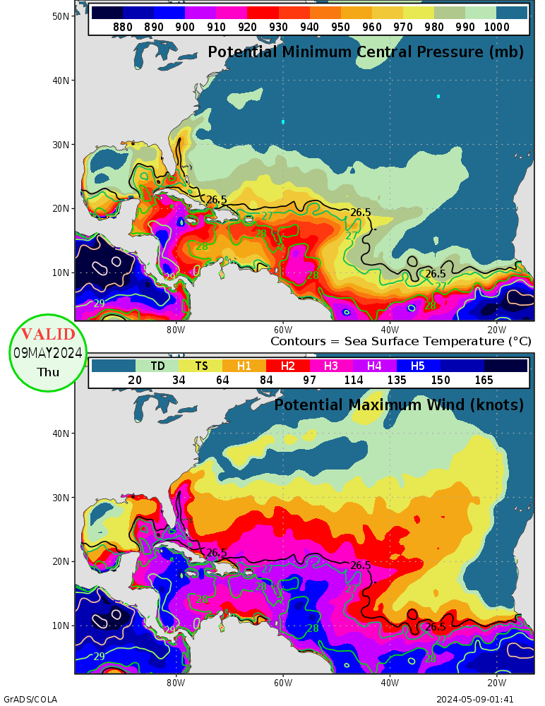
Haven't seen the SST potential maps posted yet, so here they are. Plenty of potential no matter where this thing goes.
Image
0 likes   

User avatar
Aquawind
Category 5
Category 5
Posts: 6714
Age: 62
Joined: Mon Jun 16, 2003 10:41 pm
Location: Salisbury, NC
Contact:

#340 Postby Aquawind » Sun Oct 16, 2005 8:18 am

cycloneye wrote:
tracyswfla wrote:Well if this holds true, a west coast florida hit with this intensity, I am leaving.


Also if this pans out like the models are indicating the dirty part or the strongest part of the system the right quadrant will affect the West Florida area.


Exactly..So far it looks to be affecting alot of coastline as expected coming from down there..Especially if she(Wilma) would become large and move slow..

Paul
0 likes   


Return to “Talkin' Tropics”

Who is online

Users browsing this forum: AnnularCane, Hurricaneman, hurricanes1234, riapal, TampaWxLurker and 39 guests