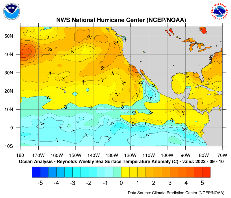
SST'S and Anomalies in Atlantic and Pacific

This is the general tropical discussion area. Anyone can take their shot at predicting a storms path.

Moderator: S2k Moderators

Forum rules

The posts in this forum are NOT official forecasts and should not be used as such. They are just the opinion of the poster and may or may not be backed by sound meteorological data. They are NOT endorsed by any professional institution or STORM2K. For official information, please refer to products from the National Hurricane Center and National Weather Service.

Help Support Storm2K
Message
Author
User avatar
Tampa Bay Hurricane
Category 5
Category 5
Posts: 5597
Age: 37
Joined: Fri Jul 22, 2005 7:54 pm
Location: St. Petersburg, FL

#201 Postby Tampa Bay Hurricane » Wed Dec 21, 2005 6:49 pm

cycloneye wrote:
Tampa Bay Hurricane wrote:I would have to say a very severe Cape Verde Season
in 2006. Homegrown storms may be big but not as
bad as Cape Verde. Look at those anomalies in the E. Atlantic.
Very Warm.

But cooler than normal close to the EGOM and east coast of the US.

So I would guess a very severe Cape Verde Season, and a more
modest homegrown season.


However you have to see how those SSTA'S look like when June arrives and not think that what is showing now will be the same by next summer as changes may occur.


Yes your right I'll keep checking each month through the summer. It's just I got a bad feeling with that heat out there near Cape Verde...
But yes stuff will change.
0 likes   

quandary
Category 1
Category 1
Posts: 362
Joined: Thu Sep 16, 2004 4:04 pm

#202 Postby quandary » Wed Dec 21, 2005 7:42 pm

Homegrown storms are easily as bad as Cape Verde Hurricanes if we use homegrown to refer to all storms produced near the coast especially with some initial baroclinic support. Let's just look at the most intense storms in history... Wilma, Rita and Katrina were all homegrown. Wilma formed at the tail end of an extratropical system interacting with a tropical wave near Jamaica. Katrina and Rita both formed in the Bermuda Triangle area, which would be more homegrown than Cape Verde. In addition, the 1935 FL Keys Hurricane did the same thing.

Gilbert, Allen and Ivan are the big Cape Verde storms, but Mitch and Camille, in addition to the already named ones, are more homegrown.
0 likes   

quandary
Category 1
Category 1
Posts: 362
Joined: Thu Sep 16, 2004 4:04 pm

#203 Postby quandary » Wed Dec 21, 2005 7:45 pm

A strong Cape Verde season, like 1999, might be good for us. Storms like Cindy and Gert will zap the energy of the ocean, unlike Katrina, Wilma and Rita, which all were extremely intense, but produced low ACE as they were brief.

It is ironic to note that the only significant storm in the last 2 years that we've had that didn't affect anything was Karl. Maria sortof counts, but it wasn't a monster (mid-range or better Cat 4). The only majors that haven't been retired since 2003 are Karl, Maria, Kate and Beta (which can't really be retired anyways).
0 likes   

User avatar
Tampa Bay Hurricane
Category 5
Category 5
Posts: 5597
Age: 37
Joined: Fri Jul 22, 2005 7:54 pm
Location: St. Petersburg, FL

#204 Postby Tampa Bay Hurricane » Thu Dec 22, 2005 12:11 am

quandary wrote:Homegrown storms are easily as bad as Cape Verde Hurricanes if we use homegrown to refer to all storms produced near the coast especially with some initial baroclinic support. Let's just look at the most intense storms in history... Wilma, Rita and Katrina were all homegrown. Wilma formed at the tail end of an extratropical system interacting with a tropical wave near Jamaica. Katrina and Rita both formed in the Bermuda Triangle area, which would be more homegrown than Cape Verde. In addition, the 1935 FL Keys Hurricane did the same thing.

Gilbert, Allen and Ivan are the big Cape Verde storms, but Mitch and Camille, in addition to the already named ones, are more homegrown.

Yes. Homegrown could absolutely be as bad or worse than Cape Verdes.
It's just interesting to speculate the origin of most of 06's storms for me.
Generally the East Coast has a higher risk with Cape Verde?
0 likes   

User avatar
sponger
S2K Supporter
S2K Supporter
Posts: 1623
Joined: Thu Jul 22, 2004 11:26 am
Location: St Augustine

#205 Postby sponger » Thu Dec 22, 2005 11:06 am

Yep, the east coast and the Gulf depending on the orientation of the Bermuda High. Maybe 06 will be the year of the fishes! We can only hope! Another Florida billion dollar storm and any one in the state pool will need another job to pay the insurance (40% rate hike for 06 and counting)
0 likes   

quandary
Category 1
Category 1
Posts: 362
Joined: Thu Sep 16, 2004 4:04 pm

#206 Postby quandary » Thu Dec 22, 2005 11:34 am

Yeah, East Coast is more threatened by the rogue long-tracking hurricane (Fran, Bonnie, Bertha, Floyd, Isabel). Fortunately, all these storms have shown signs of significant weakening before making landfall. They also tend to weaken well before landfall so the surge is not nearly as bad, unlike Katrina and Ivan, which weakened only in the last few hours or Charley and Wilma, which strengthened right up to landfall.

Of course, with the current trends and all that, the East Coast might be in line for a big one (Cat 4+). Hopefully, there just isn't nearly as much to destroy in NC, especially just along the coast.
0 likes   

User avatar
Tampa Bay Hurricane
Category 5
Category 5
Posts: 5597
Age: 37
Joined: Fri Jul 22, 2005 7:54 pm
Location: St. Petersburg, FL

#207 Postby Tampa Bay Hurricane » Thu Dec 22, 2005 7:48 pm

04/05 have been very intense years in terms of major hurricanes and
ACE.
We'll have to see if 06 does something similar.
0 likes   

User avatar
cycloneye
Admin
Admin
Posts: 146178
Age: 69
Joined: Thu Oct 10, 2002 10:54 am
Location: San Juan, Puerto Rico

#208 Postby cycloneye » Mon Dec 26, 2005 2:08 pm

Image

The latest update of the anomalys in the Atlantic Basin show a big cooldown in the Eastern gulf and off the east coast of the US.But that may be normal for this time of the year there.However look at the area west of Africa where anomalys around +2.0c to almost +3.0c are there.And in the rest of the Atlantic things are almost the same as last week with near average temps maybe slightly above readings in parts of the MDR area and in the subtropical Atlantic.
0 likes   
Visit the Caribbean-Central America Weather Thread where you can find at first post web cams,radars
and observations from Caribbean basin members Click Here

MiamiensisWx

#209 Postby MiamiensisWx » Mon Dec 26, 2005 2:47 pm

The area near Newfoundland has cooled down as well. Also, even the warm area near Africa is smaller and less intense than last week. I wonder if the Pacific is still cooling, because the Atlantic has cooled hugely now from the last few weeks.
0 likes   

User avatar
Tampa Bay Hurricane
Category 5
Category 5
Posts: 5597
Age: 37
Joined: Fri Jul 22, 2005 7:54 pm
Location: St. Petersburg, FL

#210 Postby Tampa Bay Hurricane » Fri Dec 30, 2005 12:30 pm

Although things are likely to change...IMO the 2006 Hurricane
Season could be the Killer Cape Verde Season.
Very Active Cape Verde...those waters are explosive and didn't
get drained in 2005.

Again we'll have to wait until June-August 2006 to know for sure
but I strongly believe the 2006 hurricane season will be
super-active with regards to Cape Verde Activity.
0 likes   

User avatar
WindRunner
Category 5
Category 5
Posts: 5806
Age: 34
Joined: Fri Jul 29, 2005 8:07 pm
Location: Warrenton, VA, but Albany, NY for school
Contact:

#211 Postby WindRunner » Fri Dec 30, 2005 12:35 pm

Tampa Bay Hurricane wrote:those waters are explosive and didn't
get drained in 2005.


Good point, nothing touched them all year! It might be time for the three areas that did not see an active storm all year to get busy next year: the CV region, the Northern lesser antilles, and the Appalachians.
0 likes   

User avatar
cycloneye
Admin
Admin
Posts: 146178
Age: 69
Joined: Thu Oct 10, 2002 10:54 am
Location: San Juan, Puerto Rico

#212 Postby cycloneye » Fri Dec 30, 2005 1:02 pm

Agree with the discussion from the above members,Tampa Bay Hurricane and WindRunner.What worries me is what WR said about the northern islands and I agree :eek:
0 likes   
Visit the Caribbean-Central America Weather Thread where you can find at first post web cams,radars
and observations from Caribbean basin members Click Here

MiamiensisWx

#213 Postby MiamiensisWx » Fri Dec 30, 2005 1:11 pm

I wonder why SST anomalies have cooled so much in the past few weeks while the Pacific has continued to cool. Also, the latest SST anomaly graphic I viewed yesterday shows signs that the western Pacific has more SST anomalies than the Atlantic. Does anyone think this is interesting?
0 likes   

MiamiensisWx

#214 Postby MiamiensisWx » Fri Dec 30, 2005 2:15 pm

*BUMP*
0 likes   

MiamiensisWx

#215 Postby MiamiensisWx » Sat Dec 31, 2005 7:47 pm

*BUMP*

Anyone to answer my question?
0 likes   

MiamiensisWx

#216 Postby MiamiensisWx » Mon Jan 02, 2006 1:37 pm

Image

The Atlantic SST anomalies have continued to cool. Even the area of high SST anomalies off Africa has cooled significantly. In addition, parts of the Pacific seemed to have warmed slightly. It will be interesting if an El Nino attempts to form.
0 likes   

User avatar
cycloneye
Admin
Admin
Posts: 146178
Age: 69
Joined: Thu Oct 10, 2002 10:54 am
Location: San Juan, Puerto Rico

#217 Postby cycloneye » Mon Jan 02, 2006 1:38 pm

Image

This weeks update of the Atlantic anomalys show less warm readings off the COA area but still there are values around +1.5c there.At the MDR area the temps are near normal around +0.5c.Where is really cool is in the NE GOMwhere temps around -3.5c are found.Also off the east coast of the US cool waters are there but not as cold as the eastern GOM.In general a somewhat less warm Atlantic in this update.

Image

In the equatorial Pacific less cooler waters are seen in this weeks update especially at el nino 1-2 area off SouthAmerica.El nino 3 has pockets of cool anomalys but in general neutral ENSO is there.Let's watch both the Atlantic and Pacific to see if trends develop on both basins,in the Atlantic the trend for cooling and in the Pacific the trend for warming.
0 likes   

MiamiensisWx

#218 Postby MiamiensisWx » Mon Jan 02, 2006 1:44 pm

GO, GO EL NINO! GO, GO NEUTRAL CONDITIONS!
0 likes   

User avatar
P.K.
Professional-Met
Professional-Met
Posts: 5149
Joined: Thu Sep 23, 2004 5:57 pm
Location: Watford, England
Contact:

#219 Postby P.K. » Mon Jan 02, 2006 1:49 pm

The next BoM update is due out by the 4th Jan. :)
0 likes   

User avatar
cycloneye
Admin
Admin
Posts: 146178
Age: 69
Joined: Thu Oct 10, 2002 10:54 am
Location: San Juan, Puerto Rico

#220 Postby cycloneye » Mon Jan 02, 2006 1:50 pm

P.K. wrote:The next BoM update is due out by the 4th Jan. :)


Yes I always wait for that one. :)
0 likes   
Visit the Caribbean-Central America Weather Thread where you can find at first post web cams,radars
and observations from Caribbean basin members Click Here


Return to “Talkin' Tropics”

Who is online

Users browsing this forum: duilaslol, Killjoy12, Ulf and 34 guests