Tropical Depression Carlotta (04E) in EPAC

This is the general tropical discussion area. Anyone can take their shot at predicting a storms path.

Moderator: S2k Moderators

Forum rules

The posts in this forum are NOT official forecasts and should not be used as such. They are just the opinion of the poster and may or may not be backed by sound meteorological data. They are NOT endorsed by any professional institution or STORM2K. For official information, please refer to products from the National Hurricane Center and National Weather Service.

Help Support Storm2K
Message
Author
clfenwi
Category 5
Category 5
Posts: 3331
Joined: Thu Jun 09, 2005 12:54 pm

#21 Postby clfenwi » Tue Jul 11, 2006 4:44 pm

From the 2205Z TWD

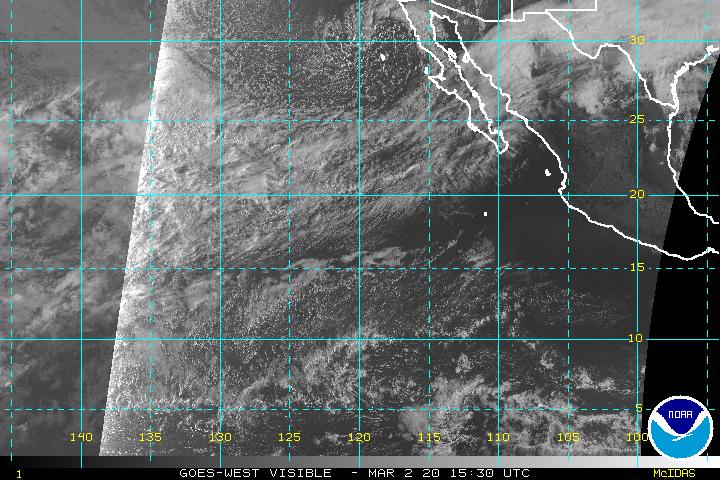
A 1008 MB LOW IS CENTERED NEAR 13N102W...ABOUT 260 NM SSW OF
ACAPULCO MEXICO...MOVING WNW A LITTLE FASTER AT 15-20 KT. THE
CONTINUES TO DISPLAY A BROAD CIRCULATION WITH DISORGANIZED
CLUSTER OF DEEP CONVECTION ROTATING MAINLY AROUND THE E AND N
SEMICIRCLES. UPPER LEVEL OUTFLOW IS RELATIVELY GOOD AROUND THE
SYSTEM...EXCEPT IS SOMEWHAT LIMITED OVER THE NW QUADRANT.
CONDITIONS WILL REMAIN FAVORABLE FOR TROPICAL DEVELOPMENT WITHIN
THE NEXT 36 HRS. IN FACT...MODEL GUIDANCE REMAINS BULLISH WITH
FORMATION...EVEN MORE SO THAN FOR T.S. BUD. SCATTERED
MODERATE/STRONG CONVECTION FROM 9N-16N BETWEEN 94W-105W.
----------------------------------------------------------------------------------------
A shot of the eastern east Pacific Pacific:

Image
0 likes   

User avatar
AnnularCane
S2K Supporter
S2K Supporter
Posts: 2872
Joined: Thu Jun 08, 2006 9:18 am
Location: Wytheville, VA

#22 Postby AnnularCane » Tue Jul 11, 2006 5:28 pm

That is one of the most beautiful invests I have ever seen. How close is she to Bud? Could there be a Fujiwara dance between the two?
0 likes   

User avatar
WindRunner
Category 5
Category 5
Posts: 5806
Age: 34
Joined: Fri Jul 29, 2005 8:07 pm
Location: Warrenton, VA, but Albany, NY for school
Contact:

#23 Postby WindRunner » Tue Jul 11, 2006 5:31 pm

You can half see it in this shot, the rest of it is under the blacked out part.

Image

EDIT: And just a note, the one on the left is now Hurricane Bud. :D
0 likes   

HurricaneHunter914
Category 5
Category 5
Posts: 4439
Age: 31
Joined: Fri Mar 10, 2006 7:36 pm
Location: College Station, TX

#24 Postby HurricaneHunter914 » Tue Jul 11, 2006 5:45 pm

90# should be moving over warmer waters soon, this will greatly strengthen this Invest.
0 likes   
Personal Forecast Disclaimer:
The posts in this forum are NOT official forecast and should not be used as such. They are just the opinion of the poster and may or may not be backed by sound meteorological data. They are NOT endorsed by any professional institution or storm2k.org. For official information, please refer to the NHC and NWS products.

User avatar
cycloneye
Admin
Admin
Posts: 145923
Age: 69
Joined: Thu Oct 10, 2002 10:54 am
Location: San Juan, Puerto Rico

#25 Postby cycloneye » Tue Jul 11, 2006 6:25 pm

ABPZ20 KNHC 112257
TWOEP
TROPICAL WEATHER OUTLOOK
NWS TPC/NATIONAL HURRICANE CENTER MIAMI FL
400 PM PDT TUE JUL 11 2006

FOR THE EASTERN NORTH PACIFIC...EAST OF 140 DEGREES WEST LONGITUDE..

THE NATIONAL HURRICANE CENTER IS ISSUING ADVISORIES ON
RECENTLY-UPGRADED HURRICANE BUD...LOCATED ABOUT 635 MILES
SOUTH-SOUTHWEST OF THE SOUTHERN TIP OF BAJA CALIFORNIA.

A LARGE TROPICAL DISTURBANCE CENTERED ABOUT 275 MILES
SOUTH-SOUTHWEST OF ACAPULCO MEXICO IS CONTINUING TO SHOW SIGNS OF
INCREASING ORGANIZATION. ENVIRONMENTAL CONDITIONS APPEAR CONDUCIVE
FOR ADDITIONAL DEVELOPMENT...AND A TROPICAL DEPRESSION COULD FORM
LATER TONIGHT OR WEDNESDAY AS THE SYSTEM MOVES WEST-NORTHWESTWARD
AT ABOUT 10-15 MPH.

ELSEWHERE...TROPICAL STORM FORMATION IS NOT EXPECTED THROUGH
WEDNESDAY.

FORECAST/ADVISORIES ON HURRICANE BUD ARE ISSUED UNDER WMO
HEADER WTPZ23 AND UNDER AWIPS HEADER MIATCMEP3.

$$
FORECASTER STEWART/RHOME

0 likes   
Visit the Caribbean-Central America Weather Thread where you can find at first post web cams,radars
and observations from Caribbean basin members Click Here

CrazyC83
Professional-Met
Professional-Met
Posts: 34009
Joined: Tue Mar 07, 2006 11:57 pm
Location: Deep South, for the first time!

#26 Postby CrazyC83 » Tue Jul 11, 2006 6:30 pm

Carlotta is just around the corner it looks like...
0 likes   

User avatar
Cyclenall
Category 5
Category 5
Posts: 6667
Joined: Thu Jun 08, 2006 10:01 pm
Location: Ontario, Canada

#27 Postby Cyclenall » Tue Jul 11, 2006 6:38 pm

They said a TD could form later tonight. That would crush my prediction of it becoming a TD tomorrow afternoon.
0 likes   

User avatar
cycloneye
Admin
Admin
Posts: 145923
Age: 69
Joined: Thu Oct 10, 2002 10:54 am
Location: San Juan, Puerto Rico

#28 Postby cycloneye » Tue Jul 11, 2006 7:00 pm

Tropical Cyclone Formation Alert

:uarrow: :uarrow: :uarrow: :uarrow: :uarrow: :uarrow:

It is now on the virge of TD status.
0 likes   

User avatar
gatorcane
S2K Supporter
S2K Supporter
Posts: 23692
Age: 47
Joined: Sun Mar 13, 2005 3:54 pm
Location: Boca Raton, FL

#29 Postby gatorcane » Tue Jul 11, 2006 7:03 pm

cycloneye wrote:Tropical Cyclone Formation Alert

:uarrow: :uarrow: :uarrow: :uarrow: :uarrow: :uarrow:

It is now on the virge of TD status.


Thanks Luis, I figured it would be. It's looking pretty darn good
0 likes   

User avatar
cycloneye
Admin
Admin
Posts: 145923
Age: 69
Joined: Thu Oct 10, 2002 10:54 am
Location: San Juan, Puerto Rico

#30 Postby cycloneye » Tue Jul 11, 2006 7:08 pm

SUBJ/TROPICAL CYCLONE FORMATION ALERT 112351Z JUL 06//
WTPN21 PHNC 120000
RMKS/
1. FORMATION OF A SIGNIFICANT TROPICAL CYCLONE IS POSSIBLE WITHIN
165 NM EITHER SIDE OF A LINE FROM 13.3N 101.1W TO 16.2N 109.4W
WITHIN THE NEXT 12 TO 24 HOURS. AVAILABLE DATA DOES NOT JUSTIFY
ISSUANCE OF NUMBERED TROPICAL CYCLONE WARNINGS AT THIS TIME.
WINDS IN THE AREA ARE ESTIMATED TO BE 20 TO 25 KNOTS. METSAT IM­
AGERY AT 111145Z INDICATES THAT A CIRCULATION CENTER IS LOCATED
NEAR 13.5N 101.7W. THE SYSTEM IS MOVING WEST-NORTHWESTWARD AT 15
KNOTS.
2. REMARKS:
3. THIS ALERT WILL BE REISSUED, UPGRADED TO WARNING OR CANCELLED BY 070000Z.
//


Above is the text of the TCFA issued.
0 likes   
Visit the Caribbean-Central America Weather Thread where you can find at first post web cams,radars
and observations from Caribbean basin members Click Here

User avatar
cycloneye
Admin
Admin
Posts: 145923
Age: 69
Joined: Thu Oct 10, 2002 10:54 am
Location: San Juan, Puerto Rico

#31 Postby cycloneye » Tue Jul 11, 2006 7:30 pm

11/2345 UTC 14.1N 102.8W T1.5/1.5 90E -- East Pacific Ocean
0 likes   
Visit the Caribbean-Central America Weather Thread where you can find at first post web cams,radars
and observations from Caribbean basin members Click Here

User avatar
Epsilon_Fan
Category 1
Category 1
Posts: 353
Joined: Fri Jan 13, 2006 1:03 pm
Location: Charleston, SC

#32 Postby Epsilon_Fan » Tue Jul 11, 2006 7:31 pm

could Bud eat this one up? They are very close to each other
0 likes   

User avatar
cycloneye
Admin
Admin
Posts: 145923
Age: 69
Joined: Thu Oct 10, 2002 10:54 am
Location: San Juan, Puerto Rico

#33 Postby cycloneye » Tue Jul 11, 2006 7:54 pm

http://tcweb.fnmoc.navy.mil/tc-bin/tc_home.cgi

NRL has changed to TD 4-E. so first advisory at 11 PM EDT or 8 PM PDT.
0 likes   
Visit the Caribbean-Central America Weather Thread where you can find at first post web cams,radars
and observations from Caribbean basin members Click Here

clfenwi
Category 5
Category 5
Posts: 3331
Joined: Thu Jun 09, 2005 12:54 pm

#34 Postby clfenwi » Tue Jul 11, 2006 8:00 pm

Epsilon_Fan wrote:could Bud eat this one up? They are very close to each other


Using the SSD estimates, they are about 620 nautical miles away from each other...Bud is moving wnw at 8 knots... 90E is moving wnw at 15-20 (TWD said 15-20, the TCFA said 15 knots, those extra few knots would make a difference)...hmm...
0 likes   

User avatar
Cyclenall
Category 5
Category 5
Posts: 6667
Joined: Thu Jun 08, 2006 10:01 pm
Location: Ontario, Canada

#35 Postby Cyclenall » Tue Jul 11, 2006 8:03 pm

Nice!! I was wrong on that one. Crow for me.

The Eastern Pacific Season is starting to heat up now. 4 TC's so far. Will TD 4-E follow in Bud's footsteps?
0 likes   

Jim Cantore

#36 Postby Jim Cantore » Tue Jul 11, 2006 8:03 pm

EPAC is picking up.
0 likes   

User avatar
WindRunner
Category 5
Category 5
Posts: 5806
Age: 34
Joined: Fri Jul 29, 2005 8:07 pm
Location: Warrenton, VA, but Albany, NY for school
Contact:

#37 Postby WindRunner » Tue Jul 11, 2006 8:05 pm

Wow . . . I even thought about calling this one this morning . . . of course I wish I had now. Definately going to be a TS by morning IMO.
0 likes   

User avatar
Cyclenall
Category 5
Category 5
Posts: 6667
Joined: Thu Jun 08, 2006 10:01 pm
Location: Ontario, Canada

#38 Postby Cyclenall » Tue Jul 11, 2006 8:23 pm

CrazyC83 wrote:I think by the end of the day, we will have at lest TD4-E on our hands.

Great call, again. No crow for you.
0 likes   

clfenwi
Category 5
Category 5
Posts: 3331
Joined: Thu Jun 09, 2005 12:54 pm

#39 Postby clfenwi » Tue Jul 11, 2006 8:25 pm

Cyclenall wrote:
CrazyC83 wrote:I think by the end of the day, we will have at lest TD4-E on our hands.

Great call, again. No crow for you.


But a helping for me... I started to fire up the grill at around 2200Z...
0 likes   

HurricaneHunter914
Category 5
Category 5
Posts: 4439
Age: 31
Joined: Fri Mar 10, 2006 7:36 pm
Location: College Station, TX

#40 Postby HurricaneHunter914 » Tue Jul 11, 2006 8:26 pm

Its like the EPAC is doing a repeat of 2005. :eek:
0 likes   
Personal Forecast Disclaimer:
The posts in this forum are NOT official forecast and should not be used as such. They are just the opinion of the poster and may or may not be backed by sound meteorological data. They are NOT endorsed by any professional institution or storm2k.org. For official information, please refer to the NHC and NWS products.


Return to “Talkin' Tropics”

Who is online

Users browsing this forum: Ian2401, Stratton23, wwizard and 62 guests