CAT 5 Hurricane Dean - Archived threads
Moderator: S2k Moderators
-
KFDM Meteorologist

- Professional-Met

- Posts: 1314
- Joined: Tue May 16, 2006 9:52 pm
- Location: Upper Texas Coast/Orange County
Re: HR Dean: For any Island in the Carib that could be affected
msbe,that is the problem;this radar is access restricted I got the password,but i cannot deliver it .So i will give to you periodic photos of the radar advance of Dean;i'am prepared since the begining of the season,as every year.
See you later
http://www.meteo.gp/pro/donnees/radar/m ... 00_ppz.gif
See you later
http://www.meteo.gp/pro/donnees/radar/m ... 00_ppz.gif
0 likes


Re: Global Models:12z GFS,NOGAPS,CMC,UKMET,GFDL Posted
12 GFDL south of New Orleans moving WNW towards SE Texas. Shifted to the left from the 6Z guidance. More in line with the consensus. Going to be interesting to see how the 00Z models change with the synoptic data coming in.
0 likes
-
Typhoon_Willie

- Category 5

- Posts: 1042
- Joined: Mon Jun 09, 2003 3:19 pm
- Location: Greenacres City, Florida
Re: Hurricane DEAN:(Page 106) Discussions, Analysis and Imagery
In weak and or developing systems center relocations do occur quite a bit. You can just about pick any storm in the past and find some mention from the Tropical Prediction Center that said storms's center has reformed during it's development phase...
0 likes


-
Sabanic

- Category 2

- Posts: 683
- Age: 66
- Joined: Wed Aug 01, 2007 7:01 am
- Location: Mobile, AL
- Contact:
Re: Global Models:12z GFS,NOGAPS,CMC,UKMET,GFDL Posted
vaffie wrote:12 GFDL south of New Orleans moving WNW towards SE Texas. Shifted to the left from the 6Z guidance. More in line with the consensus. Going to be interesting to see how the 00Z models change with the synoptic data coming in.
Texas bound ?? Maybe, maybe not . . .
0 likes

Re: Hurricane DEAN:(Page 106) Discussions, Analysis and Imagery
Tireman4 wrote:Brent wrote:Tireman4 wrote:Question...not that I am doubting anything, but is the GFS model good for tropical forecasts? Or is NAM the one that is not good? I am so confused.
NAM... the GFS is heavily used by pro mets.
Well I hope things change. Goodness. Rita taught us a lesson in Houston. I just hope we learned from it.
Well, from doing just an informal poll around the office; I'm getting the feeling that no one in Houston wants to evacuate. I pray we don't get hit by a Cat 3 or higher it could be disastrous. People saying things to me like "Oh, we aren't really that close to the coast anyway."
0 likes
-
SouthFloridawx

- S2K Supporter

- Posts: 8346
- Age: 47
- Joined: Tue Jul 26, 2005 1:16 am
- Location: Sarasota, FL
- Contact:
Re: Hurricane DEAN: Recon obs
695
URNT15 KNHC 161743
AF304 0104A DEAN HDOB 18 20070816
173600 1343N 05519W 6967 03052 9950 +081 +070 195064 066 056 032 03
173630 1342N 05518W 6970 03056 9951 +090 +070 194059 060 051 041 03
173700 1340N 05517W 6967 03062 9955 +089 +070 196055 057 048 011 00
173730 1339N 05517W 6964 03069 9958 +090 +070 196051 052 045 026 03
173800 1338N 05516W 6967 03067 9955 +093 +070 196049 049 042 018 00
173830 1337N 05515W 6968 03072 9963 +089 +070 199048 049 040 008 00
173900 1336N 05513W 6967 03074 9967 +090 +070 201047 047 039 008 00
173930 1334N 05512W 6963 03080 9971 +087 +070 199044 045 039 007 00
174000 1333N 05511W 6972 03075 9971 +091 +070 198041 042 040 007 00
174030 1332N 05510W 6971 03074 9967 +094 +070 192039 040 040 007 00
174100 1331N 05509W 6966 03081 9970 +092 +070 193038 038 040 007 00
174130 1330N 05508W 6968 03079 9972 +092 +070 192038 038 039 007 00
174200 1329N 05507W 6968 03083 9979 +089 +070 192038 039 037 007 00
174230 1328N 05505W 6967 03085 9980 +088 +070 193039 040 036 007 00
174300 1327N 05504W 6964 03090 9983 +086 +070 193040 041 035 007 00
174330 1325N 05503W 6966 03089 9988 +084 +070 190041 041 036 006 00
174400 1324N 05502W 6969 03086 9990 +085 +070 190042 043 036 007 00
174430 1323N 05501W 6964 03093 9991 +085 +070 193043 043 037 007 00
174500 1322N 05500W 6964 03095 9990 +086 +070 196044 044 035 007 00
174530 1321N 05459W 6968 03091 9994 +084 +070 194044 046 042 026 00
$$

Last edited by SouthFloridawx on Thu Aug 16, 2007 12:51 pm, edited 5 times in total.
0 likes
-
HardCard
- Tropical Depression

- Posts: 64
- Joined: Thu Sep 09, 2004 8:01 pm
- Location: Winter Garden, Fl
- Contact:
Re: Hurricane DEAN:(Page 106) Discussions, Analysis and Imagery
I think we can expect Dean to be Cat 2 by the 2AST advisory.
0 likes
-
miamicanes177
- Category 5
- Posts: 1131
- Joined: Tue Aug 01, 2006 10:53 pm
Re: Hurricane DEAN: Recon obs
172600 1359N 05545W 6969 03089 9976 +098 +070 056048 049 048 007 00
Does this mean the flight level winds are 49kts and surface winds are 48kts?
Does this mean the flight level winds are 49kts and surface winds are 48kts?
0 likes
-
Wx_Warrior
- Category 5
- Posts: 2718
- Joined: Thu Aug 03, 2006 3:58 pm
- Location: Beaumont, TX
Re: Global Models:12z GFS,NOGAPS,CMC,UKMET,GFDL Posted
Tampico to Tx/La....goodness...I dont like this model at all!
0 likes
-
Starburst

- S2K Supporter
- Posts: 484
- Joined: Sun Aug 28, 2005 11:03 pm
- Location: Beeville, TX
- Contact:
Re: Hurricane DEAN: Recon obs
Product: Air Force High Density (HDOB) Message (URNT15 KNHC)
Transmitted: 16th day of the month at 17:43Z
Date: August 16, 2007
Aircraft: Air Force Aircraft (Last digit of aircraft registration number is 304)
Storm Number: 04
Storm Name: Dean (in the North Atlantic basin)
Mission Number: 1
Observation Number: 18
Time (Z) / Coordinates / Acft. Static Air Press. / Acft. Geo. Hgt. / Extrap. Sfc. Press. / Flt. Lvl. Wind (30s) / Peak (10s) Flt. Lvl. Wind / SFMR Peak (10s) Sfc. Wind / SFMR Rain Rate
17:36:00 13.72N 55.32W 696.7 mb 3,052 m 995.0 mb From 195° (SSW) at 64 kts (73.6 mph) 66 kts (~ 75.9 mph) 56 kts* 32 mm/hr*
17:36:30 13.70N 55.30W 697.0 mb 3,056 m 995.1 mb From 194° (SSW) at 59 kts (67.8 mph) 60 kts (~ 69.0 mph) 51 kts* 41 mm/hr*
17:37:00 13.67N 55.28W 696.7 mb 3,062 m 995.5 mb From 196° (SSW) at 55 kts (63.2 mph) 57 kts (~ 65.5 mph) 48 kts 11 mm/hr
17:37:30 13.65N 55.28W 696.4 mb 3,069 m 995.8 mb From 196° (SSW) at 51 kts (58.6 mph) 52 kts (~ 59.8 mph) 45 kts* 26 mm/hr*
17:38:00 13.63N 55.27W 696.7 mb 3,067 m 995.5 mb From 196° (SSW) at 49 kts (56.3 mph) 49 kts (~ 56.3 mph) 42 kts 18 mm/hr
17:38:30 13.62N 55.25W 696.8 mb 3,072 m 996.3 mb From 199° (SSW) at 48 kts (55.2 mph) 49 kts (~ 56.3 mph) 40 kts 8 mm/hr
17:39:00 13.60N 55.22W 696.7 mb 3,074 m 996.7 mb From 201° (SSW) at 47 kts (54.0 mph) 47 kts (~ 54.0 mph) 39 kts 8 mm/hr
17:39:30 13.57N 55.20W 696.3 mb 3,080 m 997.1 mb From 199° (SSW) at 44 kts (50.6 mph) 45 kts (~ 51.7 mph) 39 kts 7 mm/hr
17:40:00 13.55N 55.18W 697.2 mb 3,075 m 997.1 mb From 198° (SSW) at 41 kts (47.1 mph) 42 kts (~ 48.3 mph) 40 kts 7 mm/hr
17:40:30 13.53N 55.17W 697.1 mb 3,074 m 996.7 mb From 192° (SSW) at 39 kts (44.8 mph) 40 kts (~ 46.0 mph) 40 kts 7 mm/hr
17:41:00 13.52N 55.15W 696.6 mb 3,081 m 997.0 mb From 193° (SSW) at 38 kts (43.7 mph) 38 kts (~ 43.7 mph) 40 kts 7 mm/hr
17:41:30 13.50N 55.13W 696.8 mb 3,079 m 997.2 mb From 192° (SSW) at 38 kts (43.7 mph) 38 kts (~ 43.7 mph) 39 kts 7 mm/hr
17:42:00 13.48N 55.12W 696.8 mb 3,083 m 997.9 mb From 192° (SSW) at 38 kts (43.7 mph) 39 kts (~ 44.8 mph) 37 kts 7 mm/hr
17:42:30 13.47N 55.08W 696.7 mb 3,085 m 998.0 mb From 193° (SSW) at 39 kts (44.8 mph) 40 kts (~ 46.0 mph) 36 kts 7 mm/hr
17:43:00 13.45N 55.07W 696.4 mb 3,090 m 998.3 mb From 193° (SSW) at 40 kts (46.0 mph) 41 kts (~ 47.1 mph) 35 kts 7 mm/hr
17:43:30 13.42N 55.05W 696.6 mb 3,089 m 998.8 mb From 190° (S) at 41 kts (47.1 mph) 41 kts (~ 47.1 mph) 36 kts 6 mm/hr
17:44:00 13.40N 55.03W 696.9 mb 3,086 m - From 190° (S) at 42 kts (48.3 mph) 43 kts (~ 49.4 mph) 36 kts 7 mm/hr
17:44:30 13.38N 55.02W 696.4 mb 3,093 m 999.1 mb From 193° (SSW) at 43 kts (49.4 mph) 43 kts (~ 49.4 mph) 37 kts 7 mm/hr
17:45:00 13.37N 55.00W 696.4 mb 3,095 m - From 196° (SSW) at 44 kts (50.6 mph) 44 kts (~ 50.6 mph) 35 kts 7 mm/hr
17:45:30 13.35N 54.98W 696.8 mb 3,091 m 999.4 mb From 194° (SSW) at 44 kts (50.6 mph) 46 kts (~ 52.9 mph) 42 kts 26 mm/hr
At 17:36:00Z (first observation), the observation was 292 miles (470 km) to the E (81°) from Bridgetown, Barbados.
At 17:45:30Z (last observation), the observation was 312 miles (503 km) to the E (86°) from Bridgetown, Barbados.
Map this message:
http://www.tropicalatlantic.com/recon/p ... .00c-54.98
Suspect values are noted by an asterisk (*).
Last edited by Starburst on Thu Aug 16, 2007 12:56 pm, edited 1 time in total.
0 likes
-
Extremeweatherguy

- Category 5
- Posts: 11095
- Joined: Mon Oct 10, 2005 8:13 pm
- Location: Florida
Re: Global Models:12z GFS,NOGAPS,CMC,UKMET,GFDL Posted
I just plotted the latest GFDL track. It looks like this...
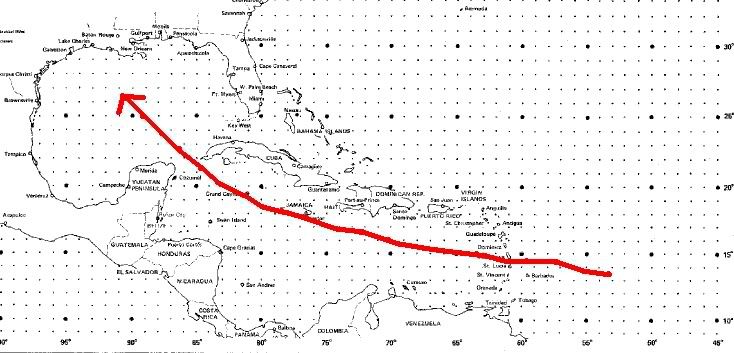
Scary! Probably the worst possible scenario for SE Texas and SW Louisiana (assuming it doesn't turn north or west after the last given GFDL point).
Scary! Probably the worst possible scenario for SE Texas and SW Louisiana (assuming it doesn't turn north or west after the last given GFDL point).
Last edited by Extremeweatherguy on Thu Aug 16, 2007 12:58 pm, edited 2 times in total.
0 likes
-
senorpepr

- Military Met/Moderator

- Posts: 12542
- Age: 43
- Joined: Fri Aug 22, 2003 9:22 pm
- Location: Mackenbach, Germany
- Contact:
Re: Hurricane DEAN: Recon obs
miamicanes177 wrote:172600 1359N 05545W 6969 03089 9976 +098 +070 056048 049 048 007 00
Does this mean the flight level winds are 49kts and surface winds are 48kts?
48KT is the 30-sec average flight level wind.
49KT is the 10-sec peak flight level wind.
0 likes
Re: Global Models:12z GFS,NOGAPS,CMC,UKMET,GFDL Posted
Sabanic wrote:vaffie wrote:12 GFDL south of New Orleans moving WNW towards SE Texas. Shifted to the left from the 6Z guidance. More in line with the consensus. Going to be interesting to see how the 00Z models change with the synoptic data coming in.
Texas bound ?? Maybe, maybe not . . .
I drew a straight line using the three last coordinates they give and the line goes into Galveston Bay.
0 likes
-
Wx_Warrior
- Category 5
- Posts: 2718
- Joined: Thu Aug 03, 2006 3:58 pm
- Location: Beaumont, TX
Re: Global Models:12z GFS,NOGAPS,CMC,UKMET,GFDL Posted
If Erin stalls, then the west ridge weakens I suppose....If this is true, I dont want the dirty side!
UP NEXT: EURO.....
UP NEXT: EURO.....
0 likes
Who is online
Users browsing this forum: No registered users and 12 guests