
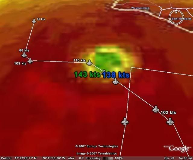
Derek Ortt wrote:according to H-WIND, May Pen did take the brunt of the storm. I expect the worst from that city, even worse than Kingston
Yeah, I'm reading that as at least 100k sustained at the surface. Devastating.
Moderator: S2k Moderators
Derek Ortt wrote:according to H-WIND, May Pen did take the brunt of the storm. I expect the worst from that city, even worse than Kingston
TampaFl wrote:Fasterdisaster, notice the wind of 81 & 114mph bottom right corner of graph. Also this is not from weatherunderground, this is the metar obs from the Kingston Airport (MKJP).


jhamps10 wrote:Cape Verde wrote:I don't buy the praying storms away stuff, but Dr. Frank does know his weather. There could be a bit of -removed- to keep the Houston viewers tuned in, but he knows more about weather than I ever will.
I agree, I mean come on people he was in charge of NHC for goodness sakes, and I just watched the video of the weathercast in question. I thought his statement was VERY reasonable, as quite frankly that low if it doesn't get to the Shore, then it could very well easily end up going to the Texas gulf coast. That is Why we keep watching this until it is dead and gone.

Texashawk wrote:Extremeweatherguy wrote:Portastorm wrote:The 0z NAM is starting to run ... it'll be interesting to see how it treats the ULL as well as Dean. Not that I trust this model at all ... only curious as its the first 0z model out for consumption and I'm kinda curious what it does with this low, if anything at all.
The 0z NAM is showing a landfall in far northeast Mexico.. http://www.nco.ncep.noaa.gov/pmb/nwprod ... 0_060l.gif
This is well north of the 18z run.. http://www.nco.ncep.noaa.gov/pmb/nwprod ... 0_066l.gif
That is.... unsettling, to say the least. And that is probably without the full brunt of a possible stalled ULL...

weatherguru18 wrote:A serious concern now guys...it appears the ULL has stalled. Why did the NHC push the cone south??
Steve wrote:>>Certainly didn't see that coming. Wait for more models before resuming panic though Texas.
That area is within the 5 day cone by the NHC.
Steve

wxmann_91 wrote:J. 18 C/ 3043 m
K. 15 C/ NA
That's a weak differential.
Not sold on Cat 5 yet for Dean, I'd like to see some higher cloud tops for that to happen. Although the current intensity, structure, and the Derek Ortt & NHC fcsts would argue a pretty high likelihood for 5.
sphelps8681 wrote:weatherguru18 wrote:A serious concern now guys...it appears the ULL has stalled. Why did the NHC push the cone south??
What will this mean for Texas?
Users browsing this forum: No registered users and 12 guests


