TD INGRID: Discussions & Images - Last Advisory

Moderator: S2k Moderators

Message
Author
User avatar
skysummit
S2K Supporter
S2K Supporter
Posts: 5305
Age: 49
Joined: Tue Aug 31, 2004 11:09 pm
Location: Ponchatoula, LA
Contact:

Re: 91L,East of Windwards: Discussions=5:30 PM TWO Shortly

#641 Postby skysummit » Tue Sep 11, 2007 4:06 pm

jdjaguar wrote:a newbie here..but I'll throw my hat in the ring and say we will have a TD by 11:00

http://www.ssd.noaa.gov/goes/flt/t2/loop-avn.html


PM or AM tomorrow? :D
0 likes   

User avatar
HURAKAN
Professional-Met
Professional-Met
Posts: 46086
Age: 38
Joined: Thu May 20, 2004 4:34 pm
Location: Key West, FL
Contact:

Re: 91L,East of Windwards: Discussions=5:30 PM TWO Shortly

#642 Postby HURAKAN » Tue Sep 11, 2007 4:07 pm

skysummit wrote:
jdjaguar wrote:a newbie here..but I'll throw my hat in the ring and say we will have a TD by 11:00

http://www.ssd.noaa.gov/goes/flt/t2/loop-avn.html


PM or AM tomorrow? :D


Unless it's close to land, the NHC won't upgrade a system without visible.
0 likes   

User avatar
Gustywind
Category 5
Category 5
Posts: 12334
Joined: Mon Sep 03, 2007 7:29 am
Location: Baie-Mahault, GUADELOUPE

#643 Postby Gustywind » Tue Sep 11, 2007 4:08 pm

000
FXCA62 TJSJ 111916
AFDSJU


NATIONAL WEATHER SERVICE SAN JUAN PR
316 PM AST TUE SEP 11 2007

AN AREA OF LOW PRESSURE
AND ASSOCIATED TROPICAL WAVE NEAR 41 WEST WILL APPROACH THE LESSER
ANTILLES LATE FRIDAY...THEN ENTER THE EASTERN CARIBBEAN ON
SATURDAY MORNING...AND MOVE ACROSS THE REGIONAL WATERS
SATURDAY THROUGH SUNDAY.

Interresting discussion...system churning near the Leewards Islands according to Puerto Rico AREA FORECAST DISCUSSION.....
:double: :roll: :eek:
0 likes   

User avatar
skysummit
S2K Supporter
S2K Supporter
Posts: 5305
Age: 49
Joined: Tue Aug 31, 2004 11:09 pm
Location: Ponchatoula, LA
Contact:

#644 Postby skysummit » Tue Sep 11, 2007 4:09 pm

TROPICAL WEATHER OUTLOOK
NWS TPC/NATIONAL HURRICANE CENTER MIAMI FL
530 PM EDT TUE SEP 11 2007

FOR THE NORTH ATLANTIC...CARIBBEAN SEA AND THE GULF OF MEXICO...

SHOWER AND THUNDERSTORM ACTIVITY HAS PERSISTED THIS AFTERNOON IN
ASSOCIATION WITH A TROPICAL WAVE AND BROAD AREA OF LOW PRESSURE
LOCATED ABOUT 1200 MILES EAST OF THE WINDWARD ISLANDS. CONDITIONS
APPEAR FAVORABLE FOR DEVELOPMENT...AND THIS SYSTEM COULD BECOME A
TROPICAL DEPRESSION WITHIN A DAY OR TWO AS IT MOVES
WEST-NORTHWESTWARD NEAR 10 MPH.

A BROAD LOW PRESSURE AREA THAT IS CENTERED ABOUT 100 MILES EAST OF
THE LOWER TEXAS COAST IS PRODUCING DISORGANIZED SHOWERS AND
THUNDERSTORMS. ENVIRONMENTAL CONDITIONS APPEAR CONDUCIVE FOR SOME
DEVELOPMENT OF THIS SYSTEM AS IT DRIFTS SLOWLY WESTWARD OVER THE
NEXT DAY OR TWO.

ELSEWHERE...TROPICAL CYCLONE FORMATION IS NOT EXPECTED DURING THE
NEXT 48 HOURS.

$$

FORECASTER PASCH/LANDSEA
0 likes   

User avatar
punkyg
Category 2
Category 2
Posts: 770
Joined: Mon Apr 23, 2007 7:37 pm
Location: sanford florida

#645 Postby punkyg » Tue Sep 11, 2007 4:11 pm

Aw nothing new with the TWO oh well lets wait til tomorrow and see if they say something else. so is convection now over the center? or is the convection still around it.
0 likes   

RL3AO
Moderator-Pro Met
Moderator-Pro Met
Posts: 16308
Joined: Thu Jun 14, 2007 10:03 pm
Location: NC

#646 Postby RL3AO » Tue Sep 11, 2007 4:12 pm

I said 11am Wednesday in the poll yesterday. I might nail it...

I guess it comes down to what it can do tonight.
0 likes   

User avatar
Extremeweatherguy
Category 5
Category 5
Posts: 11095
Joined: Mon Oct 10, 2005 8:13 pm
Location: Florida

#647 Postby Extremeweatherguy » Tue Sep 11, 2007 4:12 pm

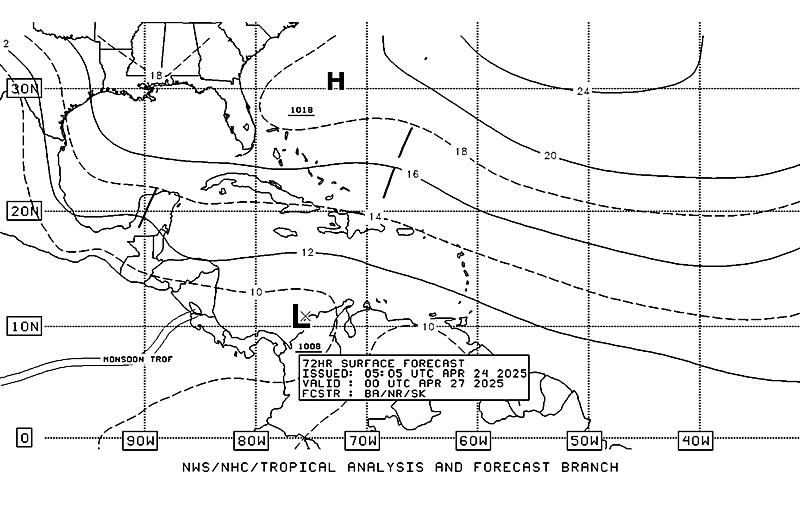
The TCP seems to disagree with the models NW movement of this system. Take a look at where they place 91L in 72 hours...

Image
0 likes   

User avatar
cycloneye
Admin
Admin
Posts: 145332
Age: 68
Joined: Thu Oct 10, 2002 10:54 am
Location: San Juan, Puerto Rico

Re:

#648 Postby cycloneye » Tue Sep 11, 2007 4:12 pm

punkyg wrote:Aw nothing new with the TWO oh well lets wait til tomorrow and see if they say something else. so is convection now over the center? or is the convection still around it.


SHOWER AND THUNDERSTORM ACTIVITY HAS PERSISTED THIS AFTERNOON IN
ASSOCIATION WITH A TROPICAL WAVE


That is new. :)
0 likes   

User avatar
HurricaneMaster_PR
Category 2
Category 2
Posts: 795
Joined: Tue Jul 22, 2003 6:23 pm
Location: San Juan, Puerto Rico

Re: 91L,East of Windwards: Discussions=5:30 PM TWO Shortly

#649 Postby HurricaneMaster_PR » Tue Sep 11, 2007 4:13 pm

It seems like TPC products (TAFB, Surface Analysis Chart) wants to take the system into the Eastern Caribbean contrary to what the the models are predicting...

18Z Surface Analysis Chart
Image

TAFB Surface Forecast 72 hours
Image
0 likes   

User avatar
skysummit
S2K Supporter
S2K Supporter
Posts: 5305
Age: 49
Joined: Tue Aug 31, 2004 11:09 pm
Location: Ponchatoula, LA
Contact:

#650 Postby skysummit » Tue Sep 11, 2007 4:13 pm

That's also an old image EWG....that's valid as of 12z.

***Editted: maybe they'll change their thinking for the next release?
Last edited by skysummit on Tue Sep 11, 2007 4:14 pm, edited 1 time in total.
0 likes   

User avatar
HurricaneMaster_PR
Category 2
Category 2
Posts: 795
Joined: Tue Jul 22, 2003 6:23 pm
Location: San Juan, Puerto Rico

Re:

#651 Postby HurricaneMaster_PR » Tue Sep 11, 2007 4:14 pm

skysummit wrote:That's also an old image EWG....that's valid as of 12z.


The new one will be out around 00Z
0 likes   

User avatar
Blown Away
S2K Supporter
S2K Supporter
Posts: 10146
Joined: Wed May 26, 2004 6:17 am

Re: 91L,East of Windwards: Discussions=5:30 PM TWO at page 33

#652 Postby Blown Away » Tue Sep 11, 2007 4:16 pm

Is 91L the EC storm JB has been talking about?
0 likes   

User avatar
punkyg
Category 2
Category 2
Posts: 770
Joined: Mon Apr 23, 2007 7:37 pm
Location: sanford florida

#653 Postby punkyg » Tue Sep 11, 2007 4:16 pm

I picked tomorrow at 5pm. that this will develop, but i don't know if it'll get organized in time.
0 likes   

Anthonyl
Tropical Depression
Tropical Depression
Posts: 97
Joined: Wed Apr 20, 2005 4:20 pm

Re: 91L,East of Windwards: Discussions=5:30 PM TWO at page 33

#654 Postby Anthonyl » Tue Sep 11, 2007 4:16 pm

Agian I may be wrong but I just can't by into the modles and expext the MHC take on this system to be more plausible.Pro Met Derek what's your take.
0 likes   

User avatar
Gustywind
Category 5
Category 5
Posts: 12334
Joined: Mon Sep 03, 2007 7:29 am
Location: Baie-Mahault, GUADELOUPE

Re:

#655 Postby Gustywind » Tue Sep 11, 2007 4:18 pm

punkyg wrote:Aw nothing new with the TWO oh well lets wait til tomorrow and see if they say something else. so is convection now over the center? or is the convection still around it.


HI punkyg , how are you , nice to see you!
I continue to monitor this system carefully, very interressing system... :cheesy: :D
0 likes   

jdjaguar
Category 2
Category 2
Posts: 551
Joined: Fri Aug 26, 2005 12:07 pm
Location: Jacksonville Beach, FL

Re: 91L,East of Windwards: Discussions=5:30 PM TWO Shortly

#656 Postby jdjaguar » Tue Sep 11, 2007 4:19 pm

skysummit wrote:
jdjaguar wrote:a newbie here..but I'll throw my hat in the ring and say we will have a TD by 11:00

http://www.ssd.noaa.gov/goes/flt/t2/loop-avn.html


PM or AM tomorrow? :D


Personal upgrade PM.

Official upgrade AM.

:D
0 likes   

Weatherfreak000

#657 Postby Weatherfreak000 » Tue Sep 11, 2007 4:19 pm

There is currently no real reason to assume the storm is heading towards the East Coast.

Model guidance typically always shows this scenario for invests in this area (Pre-Dean/Felix anyone?)

The point here is regardless whether it's a Caribbean storm or not, it's September and there is no more reason to assume the High Pressure is going to save the CONUS now.

I personally am not seeing a fish with 91L and believe a Caribbean track is most likely. But obviously it's just as likely as dissipation.
0 likes   

Derek Ortt

Re: 91L,East of Windwards: Discussions=5:30 PM TWO at page 33

#658 Postby Derek Ortt » Tue Sep 11, 2007 4:19 pm

a track primarily to the WNW; however, center reformations to the north of the actual track are likely
0 likes   

User avatar
canegrl04
Category 5
Category 5
Posts: 2486
Joined: Thu Aug 26, 2004 5:37 pm
Location: Texas

Re: 91L,East of Windwards: Discussions=5:30 PM TWO at page 33

#659 Postby canegrl04 » Tue Sep 11, 2007 4:21 pm

I say TD by 11am Wed.,too
0 likes   

User avatar
punkyg
Category 2
Category 2
Posts: 770
Joined: Mon Apr 23, 2007 7:37 pm
Location: sanford florida

#660 Postby punkyg » Tue Sep 11, 2007 4:25 pm

I'm doing good Gusty. :D
Hey guys on the navy/NRL site they said that the pressure for 91L is down to 1009mb. and now the winds are up to 25kts if you didn't know
0 likes   


Return to “2007”

Who is online

Users browsing this forum: No registered users and 12 guests