INVEST 92L: Bahamas : Gone fron NRL
Moderator: S2k Moderators

Re: INVEST 92L : Near Bahamas : Discussions & Images
Only care right now about whether this comes together and what might drive intensification. We could have just a wave drifting past. But there's always that Andros-to-Craig Key nightmare intensification to remember. Seems only the small ones do that, or whatever causes it keeps em small and winds em up very fast.
Not too worried the way it's looking now, but it's pretty close for comfort if it get's going.
Tracks SW from the Bahamas are good for the Keys but seem a bit odd. What's the confidence in that high setup?
Not too worried the way it's looking now, but it's pretty close for comfort if it get's going.
Tracks SW from the Bahamas are good for the Keys but seem a bit odd. What's the confidence in that high setup?
0 likes


-
Extremeweatherguy

- Category 5

- Posts: 11095
- Joined: Mon Oct 10, 2005 8:13 pm
- Location: Florida
Re:
That would truely be crazy if it played out. A storm of that size would mean that I could feel effects here in Houston even with the storm being hundreds of miles away..even to my east.Derek Ortt wrote:I am expecting a TC as large as the WPAC typhoons based upon the initial vortex size and model solutions.
if this gets into the GOM, it will probably take up most of the GOM
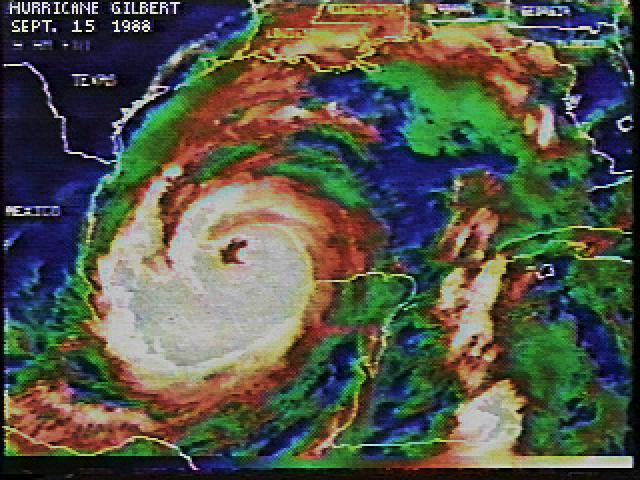
BTW..Gilbert is a good example of a large GOM storm. It likely will never be as strong as Gilbert was, but if Derek is correct then the overall size could be comparable:

Last edited by Extremeweatherguy on Wed Oct 03, 2007 11:01 pm, edited 2 times in total.
0 likes
-
'CaneFreak

- Category 5
- Posts: 1487
- Joined: Mon Jun 05, 2006 10:50 am
- Location: New Bern, NC
boy gotta love the one-liners.....geez...kids these days...ok folks...if you want to post something it needs to have some scientific credibility so that others don't get false information because some people come to this site for real information...not trying to play mod here but for once could we back up our statements? Thanks. Meteorology is a science so why? is a common question asked when you get the one-liners going.
0 likes
-
americanrebel
-
bocadude86
- Tropical Depression

- Posts: 52
- Joined: Wed Sep 12, 2007 3:29 pm
- Location: Boca Raton, Fl
-
deltadog03

- Professional-Met

- Posts: 3580
- Joined: Tue Jul 05, 2005 6:16 pm
- Location: Macon, GA


Re: INVEST 92L : Near Bahamas : Discussions & Images
Well...there is the possibility that 92L might never get going and be another all bark no biter like just about everything else so far this season. There is no LLC established with this system and it is very disorganized at the moment. The deeper almost black reds that look really dark in some of those t-storms are real impressive on IR tonight. Looks like it is just going take awhile due to the size of this system. You would think that 92L has more of an opportunity to become something more significant than the other invests with a track the models are showing. One thing for sure is this storm does have the potential to be one the most interesting tracks this season. Guess we will all know more by Saturday if this looks to be a real deal or not.
Last edited by robert_88 on Wed Oct 03, 2007 11:05 pm, edited 1 time in total.
0 likes
-
cycloneye

- Admin

- Posts: 149283
- Age: 69
- Joined: Thu Oct 10, 2002 10:54 am
- Location: San Juan, Puerto Rico
Re: INVEST 92L : Models Thread=00z GFS Rolling in at page 6
For the members that came in recent minutes to Talking Tropics forum,the 00z GFS run is being posted in a post at page 6.But if anyone has a comment about the run,you can post while I post the 00z run.
0 likes
Re:
americanrebel wrote:I would like to know why windly thinks that also. A lot of the models and stuff in the climate says that this could be a very large intense storm in about 3-4 days and still have a few days until it makes landfall where ever it does.
Of course storms can do that but this isn't a storm yet, so very large and intense in 3-4 days is optomistic IMO, or pessimistic, depending on where you are.
0 likes
-
'CaneFreak
- Category 5
- Posts: 1487
- Joined: Mon Jun 05, 2006 10:50 am
- Location: New Bern, NC
Re: INVEST 92L : Near Bahamas : Discussions & Images
robert_88 wrote:Well...there is the possibility that 92L might never get going and be another all bark no biter like just about everything else so far this season. There is no LLC established with this system and it is very disorganized at the moment. The deeper almost black reds that look really dark in some of those t-storms are real impressive tonight. Looks like it is just going take awhile due to the size of this system. You would think that 92L has more of an opportunity to become something more significant than the other invests with a track the models are showing. This storm does have the potential to be one the most interesting tracks this season. Guess we will all know more by Saturday if this looks to be a real deal or not.
It may not take that long rob...I mean..its disorganized now...but you just wait until tomorrow...that center needs to center itself under the anticyclone in the central bahamas right now and you will be surprised what 24 to 48 hours can do in the tropics..trust me...you'll see. Personally, I think this could be the big event we have been waiting for all season. There is too much energy piled into one area for nothing to develop whatsoever with light UL shear and all. It just does not bode well if you dont want a strong TC striking land somewhere.
0 likes
-
Extremeweatherguy
- Category 5
- Posts: 11095
- Joined: Mon Oct 10, 2005 8:13 pm
- Location: Florida
-
americanrebel
http://www.ssd.noaa.gov/goes/east/carb/loop-wv.html
Looking at this looks like the LLC might be around 25.5N and 72.5W.
Just might be decieving but it looks like the LLC is forming there.
Looking at this looks like the LLC might be around 25.5N and 72.5W.
Just might be decieving but it looks like the LLC is forming there.
0 likes
-
'CaneFreak
- Category 5
- Posts: 1487
- Joined: Mon Jun 05, 2006 10:50 am
- Location: New Bern, NC
Re:
americanrebel wrote:http://www.ssd.noaa.gov/goes/east/carb/loop-wv.html
Looking at this looks like the LLC might be around 25.5N and 72.5W.
Just might be decieving but it looks like the LLC is forming there.
Yep..i agree...northern side is trying to gain some convection...see...what did I tell you? That LLC is trying to find the best environment to intensify and consolidate in and it is finding it closer to the CENTER of the anticyclone!!! Now your getting it!!!
Ad lib: The tropics WANT to get rid of this extra energy and it does so through building of hurricanes. That is how it does that when the ul conditions are right of course.
0 likes
-
cycloneye
- Admin
- Posts: 149283
- Age: 69
- Joined: Thu Oct 10, 2002 10:54 am
- Location: San Juan, Puerto Rico
Re: INVEST 92L : Models Thread=00z GFS Rolling in at page 6
Is in the Yucatan Channel,Crunch time is comming now to see if the front grabs it in this 00z run.
0 likes
Who is online
Users browsing this forum: No registered users and 32 guests