Here is the link to the first thread about this system:
viewtopic.php?f=31&t=98577
Invest 97L near Canaries - Gone from NRL
Moderator: S2k Moderators
-
TheEuropean

- Professional-Met

- Posts: 1797
- Age: 60
- Joined: Tue Sep 20, 2005 3:17 pm
- Location: Voerde, Germany
- Contact:
-
TheEuropean
- Professional-Met
- Posts: 1797
- Age: 60
- Joined: Tue Sep 20, 2005 3:17 pm
- Location: Voerde, Germany
- Contact:
Invest 97L: Models Thread
445
WHXX01 KWBC 120704
CHGHUR
TROPICAL CYCLONE GUIDANCE MESSAGE
NWS TPC/NATIONAL HURRICANE CENTER MIAMI FL
0704 UTC FRI OCT 12 2007
DISCLAIMER...NUMERICAL MODELS ARE SUBJECT TO LARGE ERRORS.
PLEASE REFER TO NHC OFFICIAL FORECASTS FOR TROPICAL CYCLONE
AND SUBTROPICAL CYCLONE INFORMATION.
ATLANTIC OBJECTIVE AIDS FOR
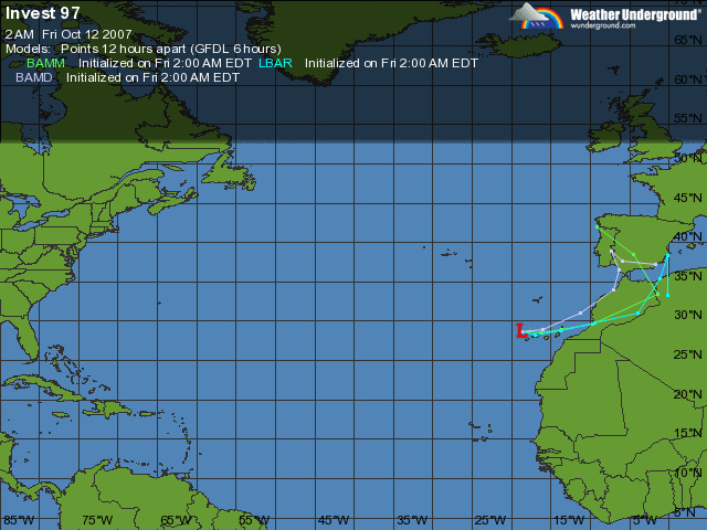
DISTURBANCE INVEST (AL972007) 20071012 0600 UTC
...00 HRS... ...12 HRS... ...24 HRS. .. ...36 HRS...
071012 0600 071012 1800 071013 0600 071013 1800
LAT LON LAT LON LAT LON LAT LON
BAMS 28.7N 18.7W 28.9N 18.9W 28.3N 19.0W 27.5N 18.8W
BAMD 28.7N 18.7W 28.9N 16.0W 31.1N 11.2W 34.0N 7.1W
BAMM 28.7N 18.7W 28.6N 17.9W 28.5N 16.3W 28.9N 13.6W
LBAR 28.7N 18.7W 28.3N 17.0W 28.8N 13.8W 29.8N 9.5W
...48 HRS... ...72 HRS... ...96 HRS. .. ..120 HRS...
071014 0600 071015 0600 071016 0600 071017 0600
LAT LON LAT LON LAT LON LAT LON
BAMS 26.7N 18.1W 26.1N 15.3W 26.0N 11.0W 27.2N 6.2W
BAMD 36.5N 6.3W 38.9N 7.4W 37.7N 6.0W 37.2N 1.7E
BAMM 29.6N 9.7W 33.5N 1.5W 38.5N 4.5E 42.0N 9.2E
LBAR 31.1N 4.0W 35.4N 1.2E 38.3N .2E 33.3N .2E
...INITIAL CONDITIONS...
LATCUR = 28.7N LONCUR = 18.7W DIRCUR = 150DEG SPDCUR = 7KT
LATM12 = 30.0N LONM12 = 19.5W DIRM12 = 189DEG SPDM12 = 11KT
LATM24 = 31.3N LONM24 = 17.6W
WNDCUR = 25KT RMAXWD = 30NM WNDM12 = 25KT
CENPRS = 1008MB OUTPRS = 1013MB OUTRAD = 150NM SDEPTH = D
RD34NE = 0NM RD34SE = 0NM RD34SW = 0NM RD34NW = 0NM
$$
NNNN
WHXX01 KWBC 120704
CHGHUR
TROPICAL CYCLONE GUIDANCE MESSAGE
NWS TPC/NATIONAL HURRICANE CENTER MIAMI FL
0704 UTC FRI OCT 12 2007
DISCLAIMER...NUMERICAL MODELS ARE SUBJECT TO LARGE ERRORS.
PLEASE REFER TO NHC OFFICIAL FORECASTS FOR TROPICAL CYCLONE
AND SUBTROPICAL CYCLONE INFORMATION.
ATLANTIC OBJECTIVE AIDS FOR
DISTURBANCE INVEST (AL972007) 20071012 0600 UTC
...00 HRS... ...12 HRS... ...24 HRS. .. ...36 HRS...
071012 0600 071012 1800 071013 0600 071013 1800
LAT LON LAT LON LAT LON LAT LON
BAMS 28.7N 18.7W 28.9N 18.9W 28.3N 19.0W 27.5N 18.8W
BAMD 28.7N 18.7W 28.9N 16.0W 31.1N 11.2W 34.0N 7.1W
BAMM 28.7N 18.7W 28.6N 17.9W 28.5N 16.3W 28.9N 13.6W
LBAR 28.7N 18.7W 28.3N 17.0W 28.8N 13.8W 29.8N 9.5W
...48 HRS... ...72 HRS... ...96 HRS. .. ..120 HRS...
071014 0600 071015 0600 071016 0600 071017 0600
LAT LON LAT LON LAT LON LAT LON
BAMS 26.7N 18.1W 26.1N 15.3W 26.0N 11.0W 27.2N 6.2W
BAMD 36.5N 6.3W 38.9N 7.4W 37.7N 6.0W 37.2N 1.7E
BAMM 29.6N 9.7W 33.5N 1.5W 38.5N 4.5E 42.0N 9.2E
LBAR 31.1N 4.0W 35.4N 1.2E 38.3N .2E 33.3N .2E
...INITIAL CONDITIONS...
LATCUR = 28.7N LONCUR = 18.7W DIRCUR = 150DEG SPDCUR = 7KT
LATM12 = 30.0N LONM12 = 19.5W DIRM12 = 189DEG SPDM12 = 11KT
LATM24 = 31.3N LONM24 = 17.6W
WNDCUR = 25KT RMAXWD = 30NM WNDM12 = 25KT
CENPRS = 1008MB OUTPRS = 1013MB OUTRAD = 150NM SDEPTH = D
RD34NE = 0NM RD34SE = 0NM RD34SW = 0NM RD34NW = 0NM
$$
NNNN
0 likes

Re: Invest 97L near Canaries - Discussions & Images
On NRL: http://www.nrlmry.navy.mil/tc_pages/tc_home.html
From the 5:30am TWO:
SHOWER ACTIVITY HAS INCREASED A LITTLE THIS MORNING IN ASSOCIATION
WITH A NON-TROPICAL LOW CENTERED JUST WEST OF THE CANARY ISLANDS.
ADDITIONAL DEVELOPMENT OF THIS SYSTEM IS EXPECTED TO BE SLOW TO
OCCUR AS IT MOVES EASTWARD.
FORECASTER BEVEN
From the 5:30am TWO:
SHOWER ACTIVITY HAS INCREASED A LITTLE THIS MORNING IN ASSOCIATION
WITH A NON-TROPICAL LOW CENTERED JUST WEST OF THE CANARY ISLANDS.
ADDITIONAL DEVELOPMENT OF THIS SYSTEM IS EXPECTED TO BE SLOW TO
OCCUR AS IT MOVES EASTWARD.
FORECASTER BEVEN
0 likes
-
TheEuropean
- Professional-Met
- Posts: 1797
- Age: 60
- Joined: Tue Sep 20, 2005 3:17 pm
- Location: Voerde, Germany
- Contact:
Re: Invest 97L near Canaries - Discussions & Images
12/0600 UTC 28.7N 18.7W ST1.5/1.5 97L -- Atlantic Ocean

1008mb, 25kts
1008mb, 25kts
0 likes
-
TheEuropean
- Professional-Met
- Posts: 1797
- Age: 60
- Joined: Tue Sep 20, 2005 3:17 pm
- Location: Voerde, Germany
- Contact:
Re: Invest 97L near Canaries - Discussions & Images
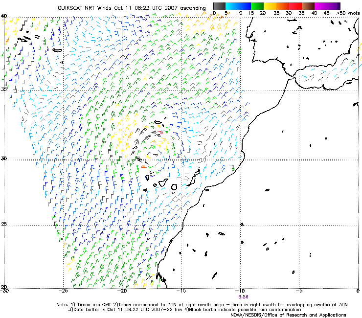
Quikscat yesterday:
Quikscat today:
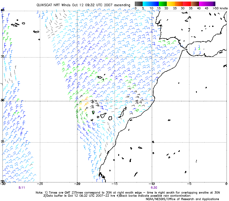
It looked better yesterday, but why wasn't it an invest or a subtropical depression yesterday?
Quikscat today:
It looked better yesterday, but why wasn't it an invest or a subtropical depression yesterday?
0 likes
-
TheEuropean
- Professional-Met
- Posts: 1797
- Age: 60
- Joined: Tue Sep 20, 2005 3:17 pm
- Location: Voerde, Germany
- Contact:
-
P.K.

- Professional-Met
- Posts: 5149
- Joined: Thu Sep 23, 2004 5:57 pm
- Location: Watford, England
- Contact:
Re: Invest 97L near Canaries - Discussions & Images
For some reason this low appears to listed twice here with different centre pressures.
FQNT50 LFPW 120908
A
SECURITE
Weather bulletin for METAREA 2, METEO-FRANCE,
Toulouse, Friday 12 October 2007 at 09 UTC.
- Wind speed in BEAUFORT SCALE - Sea : Total significant -
- Please be aware, wind gusts can be a further 40 percent stronger
than the averages given here, and maximum waves may be up to twice
the significant height.
Part 1 : WARNING 464.
Part 2 : General synopsis, Friday 12 at 00 UTC
Low 969 between Greenland and Iceland, gradually filling with
little move. Associated cold front extended from west of Ireland to
south of Azores island, with little move.
High 1022 38N40W, drifting east and building, expected 1026 just
west of Azores islands by 13/12UTC.
High 1028 just southwest of British Isles, drifting northeast,
expected 1030 over Germany by 13/12UTC.
Shallow thundery low 1010 around Canary Islands extended with
trough to Gibraltar Strait, with little change, trough slightly
deepening just south of strait by 13/00UTC.
Thundery low 1008 near Canary islands, slow-moving.
ITCZ along 11N14W 7N28W 7N44W.
Part 3 : Area forecasts to Saturday 13 at 12 UTC
FARADAY :
Southwest or West 3 to 5, gradually veering Northwest 3 or 4, but
backing Southwest in west at end. Rough or very rough in westerly
swell, gradually becoming rough in northwest swell. Showers.
ROMEO :
Southerly 3 to 5, veering Northwest 2 or 3 in west soon. Moderate
or rough in westerly swell. Rain in west.
ALTAIR :
West or Northwest 3 or 4, sometimes 5, but locally Southerly in far
east at first, gradually veering Northwest or North, and backing
Southwest in west at end. Rough in northwest swell. Showers, rain
in far east at first.
CHARCOT :
Variable 1 to 3, sometimes 4. Moderate or rough in westerly swell.
Rain in west.
ACORES, IRVING :
Northeasterly 2 to 4, increasing 3 to 5 later. Moderate or rough in
northwest swell. Rain near front, showers in west.
JOSEPHINE :
Northeast 3 or 4. Moderate with northwest swell.
MADEIRA :
Northeast 4 or 5, increasing sometimes 6 with severe gusts.
Moderate with northwest swell. Showers locally thundersqualls.
PAZENN :
East or Southeast 3 or 4. Moderate with westerly swell.
IROISE :
Mainly East 2 or 3. Moderate with westerly swell. Fog patches.
YEU, ROCHEBONNE :
East or Northeast 3 or 4. Moderate with westerly swell. Sometimes
fog patches near coast.
CANTABRICO :
East or Northeast 2 to 4, sometimes 5 in west but sometimes
variable in southeast. Moderate with westerly swell.
FINISTERRE :
In north: Easterly 4 or 5, locally 6 near cape at first, decreasing
3 or 4 later. In south: Variable 1 to 3. Moderate with westerly
swell, locally rough at first.
PORTO :
Mainly East 2 or 3 backing Northeast 3 or 4 soon. Moderate with
northwest swell.
SAO VICENTE :
Mainly Northeast 2 to 4, increasing 4 or 5 in southeast later.
Moderate with northwest swell, becoming locally rough in southeast.
Some showers.
CADIZ, GIBRALTAR STRAIT :
East or Northeast 4 to 6, increasing locally 7 occasionally 8 in
and near strait soon. Moderate or rough. Some showers.
CASABLANCA :
Northeasterly 4 or 5, increasing occasionally 6 with gusts in
south. Moderate with northwest swell. Showers locally
thundersqualls.
AGADIR :
East or Northeast 4 or 5, occasionally 6 with gusts, becoming
cyclonic 2 to 4 later. Moderate with northwest swell. Showers
locally thundersqualls.
METEOR :
Far northwest : Variable 2 or 3.
Elsewhere : Northeast 3 or 4, but North at times 5 in east.
Moderate, locally rough in northwest in NW swell. Some showers.
CANARIAS, TARFAYA :
Cyclonic 3 to 5, at times 6 in CANARIAS. Moderate. Some
thundersqualls with severe gusts.
CAPE VERDE :
Northeasterly 4, at times 5. Moderate.
CAP BLANC :
North or Northwest 3 to 5. Moderate.
CAP TIMIRIS :
Northerly 4, at times 5. Moderate.
SIERRA LEONE :
Northeast 3 to 5, locally Variable 2 to 4 in southeast. Locally
rough in SE swell. Thundersqualls with severe gusts, mainly in
south.
GULF OF GUINEA :
Southerly 2 to 4. Locally rough in SE swell, decreasing.
Thundersqualls with severe gusts, in north and in Gulf.
POINTE NOIRE :
South or Southeast 3 to 5, locally Variable 2 or 3 near coasts.
Locally rough in SE swell,
decreasing. Thundersqualls with severe gusts near northern coasts.
Part 4 : outlook for next ## hours :
Shallow low over FARADAY with near gale expected. Threat of
Easterly gale over GIBRALTAR, CADIZ.
0 likes


Re:
RL3AO wrote:If it could get one solid burst of convection and maintain it that would probably do it because of relation to land.
Well given the very unusual location, they might not be so keen on upgrading this. We'll see. It looked much better yesterday.
0 likes
-
hurricanetrack

- HurricaneTrack.com

- Posts: 1781
- Joined: Tue Dec 02, 2003 10:46 pm
- Location: Wilmington, NC
- Contact:

-
Category 5

- Category 5
- Posts: 10074
- Age: 36
- Joined: Sun Feb 11, 2007 10:00 pm
- Location: New Brunswick, NJ
- Contact:
Re:
hurricanetrack wrote:Landfall in Morocco...wow. It has come to this! I can't seem to find any good, cheap flights to Morocco
LOL!
I have a question, have you ever wanted to go after a storm outside the U.S, a storm like Emily or Dean?
0 likes
-
HURAKAN

- Professional-Met
- Posts: 46084
- Age: 39
- Joined: Thu May 20, 2004 4:34 pm
- Location: Key West, FL
- Contact:
Re: Re:
Category 5 wrote:hurricanetrack wrote:Landfall in Morocco...wow. It has come to this! I can't seem to find any good, cheap flights to Morocco
LOL!
I have a question, have you ever wanted to go after a storm outside the U.S, a storm like Emily or Dean?
If I had the money and time needed to do so, I would stormchase most of the landfalling cyclones around the world. Unfortunately I don't have the time or money to do it, so I have to wait for them to come to me!!!
0 likes


Re: Invest 97L near Canaries - Gone from NRL
NHC is too slow at recognizing these systems out of the tropics, there may be several post-season upgrades, when all the data is looked back on every system.
0 likes
Who is online
Users browsing this forum: No registered users and 42 guests