Hurricane NOEL : Discussions & Images
Moderator: S2k Moderators
-
Blown Away

- S2K Supporter

- Posts: 10253
- Joined: Wed May 26, 2004 6:17 am
Re: INVEST 90L Central Caribbean : Discussions & Images
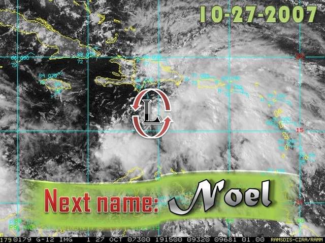
If that is the LLC near 16N/70.8W, then it looks almost completely exposed and moving NW. I may be wrong but it is not looking as impressive as we might think.
http://www.ssd.noaa.gov/goes/flt/t1/loop-vis.html
http://www.ssd.noaa.gov/goes/flt/t1/loop-vis.html
0 likes
-
Derek Ortt
-
Typhoon_Willie

- Category 5

- Posts: 1042
- Joined: Mon Jun 09, 2003 3:19 pm
- Location: Greenacres City, Florida
Re: INVEST 90L Central Caribbean : Discussions & Images
Looks a possible shift to a more wnw course as well. I thought maybe that I might see some shear affecting the system as well on the visible loop coming in from the west.
0 likes
-
Blown Away
- S2K Supporter
- Posts: 10253
- Joined: Wed May 26, 2004 6:17 am
Re:
Derek Ortt wrote:yeah, but who knows if SFWMD will artifically lower the lake again if under a TS or hurricane warning
Even thinking they would do that makes me steam!! I know your being sarcastic, they might just do it.
0 likes
-
wxman57

- Moderator-Pro Met

- Posts: 23175
- Age: 68
- Joined: Sat Jun 21, 2003 8:06 pm
- Location: Houston, TX (southwest)
Re: INVEST 90L Central Caribbean : Discussions & Images
I was just plotting the model data and notice an "OFCI" plot. That's an unofficial NHC "interpolated" forecast track based on some preliminary data someone there entered. Note that as a preliminary track, the forecaster just went right between the shallow and mid-layer BAM models. But also note that the dynamic models all turn the system northward to the east of the non-dynamic BAM models.
On satellite, it looks about the same as it has the past day or two now. Exposed low-level swirl with convection sheared off to the east. Winds 10-15 kts around the swirl. Not a TD yet, probably another 24-36 hours to go at least.

On satellite, it looks about the same as it has the past day or two now. Exposed low-level swirl with convection sheared off to the east. Winds 10-15 kts around the swirl. Not a TD yet, probably another 24-36 hours to go at least.
0 likes

Re: INVEST 90L Models Thread
Do we have a depression yet? All season for the most part models have not been too accurate with "could be" systems..Until a depression forms,I'll take models with a grain of salt..
Burned once, shame on you,burned twice, shame on me...burned beyond that number you're a masochist.....
Burned once, shame on you,burned twice, shame on me...burned beyond that number you're a masochist.....
0 likes
Re: INVEST 90L Models Thread
Let's see if we get a storm first. The models are "trending east" but where will the focus of energy end up. Looks like the Euro and NOGAPS bring it to the NW Carib/western Cuba, then "hop" over Florida and develop near the eastern seaboard (at least the NOGAPS). GFS is showing something similar, where it shows an elongated area of low pressure that snaps like a rubber band to the eastern seaboard. The HRF and GFDL are a little disturbing for me on the east coast of Florida. They both develop a cane, but seem too far east from what the Globals show. Again, I think we need to wait another day or two to see where this develops.
0 likes
-
Blown Away
- S2K Supporter
- Posts: 10253
- Joined: Wed May 26, 2004 6:17 am
Re: INVEST 90L Central Caribbean : Discussions & Images
On this path the mostly exposed LLC is moving WNW to NW towards western Haiti. Maybe the LBAR is going to get it right? 
0 likes


-
cycloneye

- Admin

- Posts: 149579
- Age: 69
- Joined: Thu Oct 10, 2002 10:54 am
- Location: San Juan, Puerto Rico
Re:
Vortex wrote:This looks to be a major flood event for Haiti....
It may be a tragic massive flooding event for them.Also the Dominican Republic will get it.Mudslides are a very big threat in DR with those big mountains.
This is what Haiti and DR will see.

0 likes
Buoy well east of LLC has very gusty winds and a rapidly falling pressure.
Station 42059 - Eastern Caribbean
Owned and maintained by National Data Buoy Center
6-meter NOMAD buoy
ARES payload
15.01 N 67.5 W (15°00'20" N 67°29'44" W)
Wind Direction (WDIR): SE ( 140 deg true )
Wind Speed (WSPD): 25.3 kts
Wind Gust (GST): 29.1 kts
Wave Height (WVHT): 6.6 ft
Dominant Wave Period (DPD): 6 sec
Average Period (APD): 4.8 sec
Atmospheric Pressure (PRES): 29.69 in
Pressure Tendency (PTDY): -0.10 in ( Falling Rapidly )
Air Temperature (ATMP): 79.5 °F
Water Temperature (WTMP): 83.3 °F
Dew Point (DEWP): 73.6 °F
Heat Index (HEAT): 83.5 °F
0 likes


-
wxman57
- Moderator-Pro Met
- Posts: 23175
- Age: 68
- Joined: Sat Jun 21, 2003 8:06 pm
- Location: Houston, TX (southwest)
Re:
bvigal wrote:2nd low has been indicated on radar looping for almost 24hrs, moving W. (I asked about it last night) That would explain the 67W buoy's readings now.
That buoy is 200nm away from the nearest radar, making the radar beam height over 30,000 feet above the surface. Any rotation you're seeing on San Juan radar is well above the surface. Here's the link to the beam height/width calculator:
http://www.wdtb.noaa.gov/tools/misc/beamwidth/beamwidth.html
0 likes
A close call..I think the next 24 hours will be crucial for S.FL.
(1)A NW/NNW track would favor Haiti, Eastern Cuba and the Bahamas.
(2)A WNW/NW track would favor Jamaica,Central/E Cuba, Western Bahamas and Extrme SE Florida.
(3)A W/WNW would favor Jamaica, Caymans, Western Cuba,Keys and S.FL.
At this point I'm going with a track between 2 and 3 and bring it over central Cuba and into the Florida Straits.
*Theres also a chance it remains S of Cuba for several days before being ejected NE late next week.
0 likes
Who is online
Users browsing this forum: No registered users and 33 guests