
Hurricane NOEL : Discussions & Images
Moderator: S2k Moderators

-
HenkL
- S2K Supporter

- Posts: 2401
- Joined: Fri Sep 10, 2004 5:33 pm
- Location: Groningen, The Netherlands
- Contact:
URNT12 KNHC 311830
VORTEX DATA MESSAGE AL162007
A. 31/17:49:00Z
B. 22 deg 33 min N
078 deg 50 min W
C. 850 mb 1385 m
D. 44 kt
E. 299 deg 82 nm
F. 034 deg 040 kt
G. 299 deg 063 nm
H. 995 mb
I. 24 C/ 335 m
J. 21 C/ 1523 m
K. 18 C/ NA
L. NA
M. NA
N. 134/8
O. 0.03 / 8 nm
P. AF302 0816A NOEL OB 08
MAX FL WIND 49 KT N QUAD 16:34:30 Z
MAX TEMP OUTSIDE EYE OUTBOUND 17C
CLIMBED TO 850MB ON INBOUND
MAX SFC WIND OUTBOUND 53 KT NE QUAD 18:16:00Z
Just a few miles SW of the previous one.
0 likes
-
feederband

- S2K Supporter
- Posts: 3423
- Joined: Wed Oct 01, 2003 6:21 pm
- Location: Lakeland Fl
Re: Tropical Storm NOEL : Discussions & Images
Mets can't be really wrong...They gather the info avaible and give their best analysis of where it may go...Things change like the weather always does and they adjust to it no biggie...
0 likes


Re: Tropical Storm NOEL Models Thread
365
WHXX01 KWBC 311835
CHGHUR
TROPICAL CYCLONE GUIDANCE MESSAGE
NWS TPC/NATIONAL HURRICANE CENTER MIAMI FL
1835 UTC WED OCT 31 2007
DISCLAIMER...NUMERICAL MODELS ARE SUBJECT TO LARGE ERRORS.
PLEASE REFER TO NHC OFFICIAL FORECASTS FOR TROPICAL CYCLONE
AND SUBTROPICAL CYCLONE INFORMATION.
ATLANTIC OBJECTIVE AIDS FOR
TROPICAL CYCLONE NOEL (AL162007) 20071031 1800 UTC
...00 HRS... ...12 HRS... ...24 HRS. .. ...36 HRS...
071031 1800 071101 0600 071101 1800 071102 0600
LAT LON LAT LON LAT LON LAT LON
BAMS 22.6N 78.8W 23.4N 80.0W 23.6N 80.6W 23.0N 80.5W
BAMD 22.6N 78.8W 23.5N 78.7W 24.9N 77.8W 26.6N 75.5W
BAMM 22.6N 78.8W 23.4N 79.2W 24.2N 78.8W 25.0N 77.3W
LBAR 22.6N 78.8W 23.2N 78.9W 24.2N 78.5W 26.0N 78.1W
SHIP 45KTS 52KTS 59KTS 63KTS
DSHP 45KTS 52KTS 59KTS 63KTS
...48 HRS... ...72 HRS... ...96 HRS. .. ..120 HRS...
071102 1800 071103 1800 071104 1800 071105 1800
LAT LON LAT LON LAT LON LAT LON
BAMS 22.4N 80.9W 21.3N 82.7W 19.3N 85.6W 16.9N 89.9W
BAMD 29.0N 71.5W 37.0N 61.8W 48.4N 53.7W 59.4N 44.6W
BAMM 26.1N 74.6W 30.9N 65.6W 38.1N 53.6W 43.7N 46.2W
LBAR 27.6N 76.9W 32.6N 71.9W 39.8N 60.5W .0N .0W
SHIP 67KTS 64KTS 60KTS 44KTS
DSHP 67KTS 64KTS 60KTS 31KTS
...INITIAL CONDITIONS...
LATCUR = 22.6N LONCUR = 78.8W DIRCUR = 0DEG SPDCUR = 0KT
LATM12 = 21.8N LONM12 = 78.1W DIRM12 = 344DEG SPDM12 = 7KT
LATM24 = 21.0N LONM24 = 77.6W
WNDCUR = 45KT RMAXWD = 75NM WNDM12 = 35KT
CENPRS = 995MB OUTPRS = 1008MB OUTRAD = 180NM SDEPTH = D
RD34NE = 100NM RD34SE = 100NM RD34SW = 0NM RD34NW = 100NM
$$
NNNN
0 likes
-
HenkL
- S2K Supporter
- Posts: 2401
- Joined: Fri Sep 10, 2004 5:33 pm
- Location: Groningen, The Netherlands
- Contact:
UZNT13 KNHC 311837
XXAA 81188 99225 70788 08028 99995 26608 13009 00544 ///// /////
92645 23007 14010 85382 19000 14512 88999 77999
31313 09608 81749
61616 AF302 0816A NOEL OB 11
62626 EYE SPL 2254N07882W 1751 MBL WND 13509 AEV 00000 =
XXBB 81188 99225 70788 08028 00995 26608 11850 19000 22843 18400
21212 00995 13009 11930 16010 22925 13510 33843 14512
31313 09608 81749
61616 AF302 0816A NOEL OB 11
62626 EYE SPL 2254N07882W 1751 MBL WND 13509 AEV 00000 =
Dropsonde in the 'eye'.
0 likes
-
wxman57

- Moderator-Pro Met

- Posts: 23175
- Age: 68
- Joined: Sat Jun 21, 2003 8:06 pm
- Location: Houston, TX (southwest)
Re: Tropical Storm NOEL : Discussions & Images
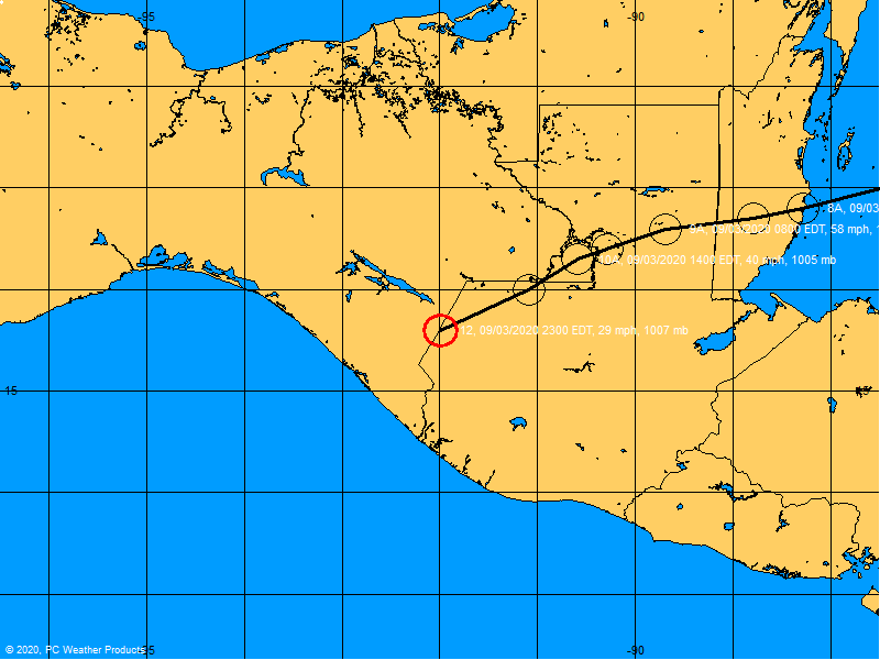
Take a look at the upper level winds on the 12Z GFS (below). As it moves northward, wind shear steadily increases. If the low-level center moves toward Florida Noel gets ripped apart by shear. Westerly winds aloft are steadily increasing across Florida, making for a very hostile environment north of Noel.
By the way, I just checked my email for a copy of the first track I issued on the disturbance (long before it became Noel). It was issued at 10am Thursday, October 25th. I had it crossing central Cuba from the south Monday night and moving N-NNE, passing 60-80 miles east of Miami today. (We issue 7-day tracks for certain customers that need a longer-range outlook on disturbances that could potentially develop into storms.)
Anyway, here's the 200mb wind flow valid 10am CDT this morning from the 12Z GFS:
0 likes
-
Canelaw99

- S2K Supporter
- Posts: 2128
- Age: 49
- Joined: Tue Aug 31, 2004 8:27 am
- Location: Homestead, FL
Re: Tropical Storm NOEL : Discussions & Images
As a member for a few years, I'm disappointed at how snippy so many people seem today. We are all interested in tropical weather or we wouldn't be here. Some of us are novice folks who come here to learn or get info, some are pro forecasters with great insight into what's going on, some are here to instigate, and some are in between. Whoever you are, you ought to still show respect to the other members of the board and what they say. Remember that you can't take everything that you read here at face value. There are many times that someone is saying something one way and people take it another. I, for one, enjoy seeing what other people's opinions are because they may be seeing something that I'm not. Now, as long as we all pay attention to what the authorities are telling us as for as pertinent info, then there's no harm done, in my opinion. I just think everyone needs to chill and not be so darn snippy LOL
Anyway, back on topic now - it will be VERY interesting to see what the NHC does at 5 as far as S FL is concerned. I don't expect a ton of horrible weather, granted, but there are plenty of people in the area who really don't have a clue what is going on, or they just brush it off. Yes, putting up warnings requires money, other things being done, but at what point does that outweigh safety for the citizens? I think that becomes the important question overall.
Anyway, back on topic now - it will be VERY interesting to see what the NHC does at 5 as far as S FL is concerned. I don't expect a ton of horrible weather, granted, but there are plenty of people in the area who really don't have a clue what is going on, or they just brush it off. Yes, putting up warnings requires money, other things being done, but at what point does that outweigh safety for the citizens? I think that becomes the important question overall.
0 likes
-
HenkL
- S2K Supporter
- Posts: 2401
- Joined: Fri Sep 10, 2004 5:33 pm
- Location: Groningen, The Netherlands
- Contact:
URNT15 KNHC 311842
AF302 0816A NOEL HDOB 45 20071031
183000 2358N 07742W 6830 03286 0008 +094 +062 096031 031 999 999 03
183030 2359N 07744W 6834 03271 0005 +090 +063 099030 031 999 999 03
183100 2359N 07747W 6832 03278 0011 +088 +067 096029 030 999 999 03
183130 2400N 07749W 6833 03292 0024 +088 +070 098026 028 999 999 03
183200 2400N 07749W 6833 03292 0029 +086 +073 097027 027 042 000 03
183230 2401N 07754W 6833 03305 0036 +085 +075 094027 028 040 000 00
183300 2402N 07757W 6832 03305 0038 +084 +074 092029 029 037 002 00
183330 2403N 07759W 6833 03306 0038 +083 +083 089027 028 037 002 00
183400 2403N 07802W 6832 03310 0040 +083 +076 081027 028 038 001 00
183430 2404N 07805W 6832 03305 0036 +085 +074 084028 029 037 002 00
183500 2405N 07807W 6833 03303 0039 +084 +071 081028 029 036 002 00
183530 2405N 07810W 6832 03304 0044 +080 +075 079028 029 037 002 00
183600 2406N 07812W 6832 03304 0039 +082 +073 081028 028 037 002 00
183630 2407N 07815W 6833 03306 0039 +082 +073 081027 028 038 001 00
183700 2408N 07817W 6832 03308 0040 +082 +073 079028 029 037 002 00
183730 2408N 07820W 6833 03303 0043 +081 +074 076030 031 037 001 00
183800 2409N 07822W 6834 03306 0048 +077 +077 077029 031 039 001 00
183830 2410N 07825W 6832 03310 0049 +076 +075 072028 028 038 002 00
183900 2410N 07825W 6832 03310 0049 +076 +074 071028 028 038 002 00
183930 2410N 07825W 6832 03310 0050 +074 +074 071027 028 038 002 00
0 likes
-
Derek Ortt
-
Evil Jeremy

- S2K Supporter
- Posts: 5463
- Age: 32
- Joined: Mon Apr 10, 2006 2:10 pm
- Location: Los Angeles, CA
Re: Tropical Storm NOEL : Discussions & Images
Derek, what do you think the NHC is going to do at 5?
0 likes
-
Derek Ortt
-
Rainband
Re: Tropical Storm NOEL : Discussions & Images
If there was a threat to the Citizens, there would be a warning.Canelaw99 wrote: Yes, putting up warnings requires money, other things being done, but at what point does that outweigh safety for the citizens? I think that becomes the important question overall.
0 likes
Re:
Derek Ortt wrote:since this is not moving, they may keep the status quo
I heard that it is the Miami NWS that is the ones preventing a TS warning from being issued.
I think the only reason they would do the TS Warning is because it is Halloween and you have the kids T&T to worry about.
0 likes
-
Evil Jeremy
- S2K Supporter
- Posts: 5463
- Age: 32
- Joined: Mon Apr 10, 2006 2:10 pm
- Location: Los Angeles, CA
Re:
Derek Ortt wrote:since this is not moving, they may keep the status quo
I heard that it is the Miami NWS that is the ones preventing a TS warning from being issued.
Really? Their allowed to do that? Well, they might change their minds after the Special Weather Statment earlier and the change of movment and uncertainity with Noel.
0 likes
-
Blown Away

- S2K Supporter
- Posts: 10253
- Joined: Wed May 26, 2004 6:17 am
Re: Tropical Storm NOEL : Discussions & Images
Convection seems to have busted through that wall we saw this morning, not as flat as it was this morning. Making its way slowly to the SFL coast. It is what it is.
http://cimss.ssec.wisc.edu/tropic/real- ... cjava.html
http://cimss.ssec.wisc.edu/tropic/real- ... cjava.html
0 likes
-
HenkL
- S2K Supporter
- Posts: 2401
- Joined: Fri Sep 10, 2004 5:33 pm
- Location: Groningen, The Netherlands
- Contact:
URNT15 KNHC 311852
AF302 0816A NOEL HDOB 46 20071031
184000 2412N 07832W 6833 03306 0043 +080 +077 071026 026 035 002 00
184030 2412N 07835W 6832 03306 0040 +084 +073 068025 026 036 001 00
184100 2413N 07837W 6832 03307 0041 +083 +072 071025 025 037 001 00
184130 2414N 07840W 6833 03308 0038 +085 +076 074026 027 036 002 00
184200 2414N 07842W 6713 03454 0037 +076 +063 072023 025 037 000 00
184230 2415N 07845W 6484 03742 0029 +066 +060 082021 022 036 001 00
184300 2415N 07847W 6329 03942 0031 +056 +040 085023 023 037 001 00
184330 2416N 07850W 6311 03971 0039 +051 +025 079023 023 038 000 00
184400 2417N 07852W 6316 03961 0040 +050 +030 077024 025 037 001 00
184430 2418N 07855W 6317 03958 0039 +052 +032 078024 025 037 002 00
184500 2418N 07858W 6317 03961 0038 +054 +034 078024 025 038 000 00
184530 2419N 07900W 6317 03960 0033 +055 +030 066027 028 037 002 00
184600 2420N 07903W 6317 03963 0036 +055 +025 060029 030 037 001 00
184630 2420N 07906W 6316 03963 0038 +053 +031 063029 029 037 002 00
184700 2420N 07906W 6316 03963 0038 +054 +031 063029 029 037 002 00
184730 2420N 07906W 6316 03963 0035 +056 +030 065029 029 037 002 00
184800 2422N 07914W 6317 03962 0037 +055 +033 068027 028 042 000 00
184830 2423N 07916W 6316 03965 0041 +054 +029 065027 028 041 000 00
184900 2424N 07919W 6317 03967 0039 +056 +020 057026 026 038 000 00
184930 2425N 07922W 6316 03973 0040 +056 +020 054024 025 039 000 00
0 likes
-
Evil Jeremy
- S2K Supporter
- Posts: 5463
- Age: 32
- Joined: Mon Apr 10, 2006 2:10 pm
- Location: Los Angeles, CA
-
shinglesflyin
- Tropical Wave

- Posts: 1
- Joined: Tue Oct 30, 2007 4:58 pm
I am by no means even an amateur (I enjoy reading the posts of all of you that are) but the system is still in the cone isn't it? So why are so many so critical of the NHC for there forecasts? To me storms like this are fun to watch, it’s similar to watching Tiger woods and the rest of the PGA at a US Open! Sometimes even the best pull their hair out with difficult conditions!
0 likes
Who is online
Users browsing this forum: No registered users and 28 guests