I'm in the middle of this one. Some very heavy rain and a few thunderstorms coming up my way in the next few hours.
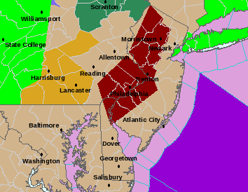
FLASH FLOOD WARNING
DEC003-NJC005-007-015-021-033-PAC017-029-045-091-101-082100-
/O.NEW.KPHI.FF.W.0002.080308T1703Z-080308T2100Z/
/00000.0.ER.000000T0000Z.000000T0000Z.000000T0000Z.OO/
BULLETIN - EAS ACTIVATION REQUESTED
FLASH FLOOD WARNING
NATIONAL WEATHER SERVICE MOUNT HOLLY NJ
1203 PM EST SAT MAR 8 2008
THE NATIONAL WEATHER SERVICE IN MOUNT HOLLY NJ HAS ISSUED A
* FLASH FLOOD WARNING FOR...
MERCER COUNTY IN CENTRAL NEW JERSEY...
THIS INCLUDES THE CITY OF TRENTON...
NEW CASTLE COUNTY IN NORTHERN DELAWARE...
THIS INCLUDES THE CITY OF WILMINGTON...
BUCKS COUNTY IN SOUTHEAST PENNSYLVANIA...
CHESTER COUNTY IN SOUTHEAST PENNSYLVANIA...
DELAWARE COUNTY IN SOUTHEAST PENNSYLVANIA...
MONTGOMERY COUNTY IN SOUTHEAST PENNSYLVANIA...
PHILADELPHIA COUNTY IN SOUTHEAST PENNSYLVANIA...
THIS INCLUDES THE CITY OF PHILADELPHIA...
NORTHWESTERN BURLINGTON COUNTY IN SOUTHERN NEW JERSEY...
CAMDEN COUNTY IN SOUTHERN NEW JERSEY...
THIS INCLUDES THE CITY OF CAMDEN...
GLOUCESTER COUNTY IN SOUTHERN NEW JERSEY...
SALEM COUNTY IN SOUTHERN NEW JERSEY...
* UNTIL 400 PM EST
* AT 1159 AM EST...NATIONAL WEATHER SERVICE DOPPLER RADAR
INDICATED AN AREA OF VERY HEAVY RAIN ASSOCIATED WITH SHOWERS AND
THUNDERSTORMS MOVING OVER THE WARNED AREA.
* LOCATIONS IN THE WARNING INCLUDE BUT ARE NOT LIMITED TO
PHILADELPHIA...BENSALEM...WILLOW GROVE...DREXEL HILL...
DOYLESTOWN...DOWNINGTOWN...BRISTOL...RIVERSIDE...MOUNT HOLLY...
LINDENWOLD AND GLOUCESTER CITY
EXCESSIVE RUNOFF FROM HEAVY RAINFALL WILL CAUSE FLOODING OF SMALL
CREEKS AND STREAMS...URBAN AREAS...HIGHWAYS...STREETS AND UNDERPASSES
AS WELL AS OTHER DRAINAGE AREAS AND LOW LYING SPOTS.
DO NOT DRIVE YOUR VEHICLE INTO AREAS WHERE THE WATER COVERS THE
ROADWAY. THE WATER DEPTH MAY BE TOO GREAT TO ALLOW YOUR CAR TO CROSS
SAFELY. MOVE TO HIGHER GROUND.
LAT...LON 3942 7547 3945 7554 3940 7551 3938 7555
3946 7558 3944 7555 3950 7557 3957 7553
3958 7554 3948 7559 4007 7583 4053 7522
4044 7506 4040 7504 4039 7496 4033 7493
4034 7487 4024 7469 3996 7455
TIME...MOT...LOC 1703Z 180DEG 0KT 3967 7552
$$
SZATKOWSKI/KRUZDLO
2008 Severe Weather Thread
Moderator: S2k Moderators
Forum rules

The posts in this forum are NOT official forecast and should not be used as such. They are just the opinion of the poster and may or may not be backed by sound meteorological data. They are NOT endorsed by any professional institution or STORM2K.
-
Category 5

- Category 5

- Posts: 10074
- Age: 36
- Joined: Sun Feb 11, 2007 10:00 pm
- Location: New Brunswick, NJ
- Contact:
Re: 2008 Severe Weather thread
0 likes
-
Category 5
- Category 5
- Posts: 10074
- Age: 36
- Joined: Sun Feb 11, 2007 10:00 pm
- Location: New Brunswick, NJ
- Contact:
Re: 2008 Severe Weather thread
the entire western half of New Jersey is under a flash flood warning
0 likes
-
Ed Mahmoud
Re: 2008 Severe Weather thread
SWODY 3 has TX and LA in a "See Text", and the long range SPC outlook has the Lower Mississippi Valley in a risk area Day 4, but I'm still more gung-ho about a Sunday-Tuesday event.
Re: SWODY3 "See Text" discussion
12Z WRF brings a decent little disturbance out of Mexico into Texas, just in time to spark some activity near HOU.

GFS much more subtle

WRF sounding shows very little instability in below 800 mb, and not much speed or directional shear where there is elevated instability, and the WRF is the more agressive model, so I'm not gung-ho on severe Thursday, yet.

Re: SWODY3 "See Text" discussion
12Z WRF brings a decent little disturbance out of Mexico into Texas, just in time to spark some activity near HOU.
GFS much more subtle
WRF sounding shows very little instability in below 800 mb, and not much speed or directional shear where there is elevated instability, and the WRF is the more agressive model, so I'm not gung-ho on severe Thursday, yet.
0 likes
-
Ed Mahmoud
Re: 2008 Severe Weather thread
TORNADO WARNING
FLC021-111700-
/O.NEW.KMFL.TO.W.0017.080311T1631Z-080311T1700Z/
BULLETIN - EAS ACTIVATION REQUESTED
TORNADO WARNING
NATIONAL WEATHER SERVICE MIAMI FL
1231 PM EDT TUE MAR 11 2008
THE NATIONAL WEATHER SERVICE IN MIAMI HAS ISSUED A
* TORNADO WARNING FOR...
SOUTH CENTRAL COLLIER COUNTY IN SOUTH FLORIDA.
* UNTIL 100 PM EDT
* AT 1228 PM EDT...NATIONAL WEATHER SERVICE DOPPLER RADAR INDICATED A
SEVERE THUNDERSTORM CAPABLE OF PRODUCING A TORNADO NEAR EVERGLADES
CITY...MOVING NORTHEAST AT 31 MPH.
THIS STORM IS ALSO CAPABLE OF PRODUCING DAMAGING WINDS IN EXCESS OF
60 MPH.
* THE TORNADO WILL BE NEAR...
CARNESTOWN...
OCHOPEE...
0 likes

-
Ed Mahmoud
Re: 2008 Severe Weather thread
Day 3 (Friday) has a Slight Risk, which an area of hatched probabilities over the lower Mississippi Valley, but I still think Sunday-Tuesday, or maybe Monday-Wednesday, will be a bigger deal.
Models still show a monster upper low, with low heights, and cold air aloft, moving into California this weekend.
Monday afternoon Euro surface

Euro 500 mb

0Z GFS Monday afternoon

Models still show a monster upper low, with low heights, and cold air aloft, moving into California this weekend.
Monday afternoon Euro surface
Euro 500 mb
0Z GFS Monday afternoon
0 likes

-
Ed Mahmoud
Re: 2008 Severe Weather thread
Eastern Texas and Oklahoma, and most of Arkansas and Louisiana are in a slight risk, with a hatched area for hail near the Arklatex.
I still think Monday starts the big severe weather episode.
Monday's severe weather maker in the Pacific
Now, the Euro doesn't give info on pops or instability for free, but for long lead time severe forecasting, in my practiced but extremely amateur and unofficial manner, I look for good speed/directional shear suggested by the Euro surface and 500 mb maps.
0 likes
-
Ed Mahmoud
Re: 2008 Severe Weather thread
Re: Jeff Linder- (relevant parts quoted)
That is what I am saying. Considering it is really only 8:11 am (solar time), the low clouds are doing an ok job here at the Galleria of starting to lift and break up a tad, so maybe we'll get enough of that near Equinox sunshine to break the cap.
12Z WRF suggests cap might be breakable late this afternoon. Instability a tad meager, especially the lowest 2 km of the atmosphere if the forecast sounding is correct, but good mid-level instability. If we can get a degree or two warmer than the WRF is forecasting, strong storms would be a good bet.

Just looked at my PPV model isotherms from the WRF, DW Hooks right at 20ºC, or 68ºF. It is already 57ºF. Still lots of low clouds, but I'm seeing occnl peaks of sun.
Discussion:
Upper trough moving into TX this morning with surface low pressure over SW OK and a strong low level jet over E TX. Highly modified Gulf air mass with low 60 degree dewpoints is starting to return to the coastal bend and will rapidly advect northward today as 50kt low level jet develops over SE and E TX. As surface low moves to the E this afternoon the W TX dryline will surge eastward deep into E TX. While capping is very strong…enough heating may be had by late afternoon along with surface forcing along the dryline to lift surface based energy through the capped layer and allowed thunderstorms to develop. Given the expected cap intensity advecting NE off the higher terrain of NE Mexico I suspect only a few storms will be able to develop and mainly along and E of US 59 and E of SH 288. It should be noted that both the NAM and GFS are showing more development this afternoon than their previous runs!
Early Next Week:
Big upper trough will carve into the SW US this weekend and begins its eastward track early next week in highly progressive US flow. Long period of return Gulf flow should result in a moderate to possibly highly unstable air mass by Monday. Looks like high rain chances are in the offing along with good severe potential. Close watch is needed on this system.
That is what I am saying. Considering it is really only 8:11 am (solar time), the low clouds are doing an ok job here at the Galleria of starting to lift and break up a tad, so maybe we'll get enough of that near Equinox sunshine to break the cap.
12Z WRF suggests cap might be breakable late this afternoon. Instability a tad meager, especially the lowest 2 km of the atmosphere if the forecast sounding is correct, but good mid-level instability. If we can get a degree or two warmer than the WRF is forecasting, strong storms would be a good bet.
Just looked at my PPV model isotherms from the WRF, DW Hooks right at 20ºC, or 68ºF. It is already 57ºF. Still lots of low clouds, but I'm seeing occnl peaks of sun.
0 likes
-
Ed Mahmoud
Re: 2008 Severe Weather thread
15Z RUC sounding still predicts a cap, but extreme mid-level instability, and some speed shear in the unstable layer. Looks like a potential hail sounding, for any cells that can break the cap.

Only thing is, RUC suggests storms will be very isolated.
The RUC does seem to suggest storms fire somewhat East of the Metroplex, just after 7 pm CDT.
Greenville, TX 7 pm forecast sounding from the 15Z RUC does look impressive...

Only thing is, RUC suggests storms will be very isolated.
The RUC does seem to suggest storms fire somewhat East of the Metroplex, just after 7 pm CDT.
Greenville, TX 7 pm forecast sounding from the 15Z RUC does look impressive...
0 likes
-
Ed Mahmoud
Re: 2008 Severe Weather thread
I can see where the dryline is on satellite, and the GRK radar showed a shower or two trying to pop, but it looks like most/all the action stays in far NE Texas and points North and East.

4 severe warnings currently in Arkansas
4 severe warnings currently in Arkansas
0 likes
-
Ed Mahmoud
Re: 2008 Severe Weather thread
Monday afternoon/evening Oklahoma & North and Northwest Texas

GFS instability forecast (MUCAPE)

Forecast Abilene sounding from GFS Monday late afternoon

Tuesday afternoon/evening: Missouri to Southeast Texas and Louisiana

For Monday, Euro sees a 40 knot low level jet:

and a deep 500 mb trough:

As mentioned, thse areas are in the general Day 4, then Day 5 SPC outlook.
GFS instability forecast (MUCAPE)
Forecast Abilene sounding from GFS Monday late afternoon
Tuesday afternoon/evening: Missouri to Southeast Texas and Louisiana
For Monday, Euro sees a 40 knot low level jet:
and a deep 500 mb trough:
As mentioned, thse areas are in the general Day 4, then Day 5 SPC outlook.
0 likes
-
Ed Mahmoud
Re: 2008 Severe Weather thread
 DOUBLE POST ALERT
 In the WRF window now for Monday. MUCAPE in excess of 1000 J/Kg, and deep layer shear 50 knots and higher Southern Oklahoma and North Texas, well...
Added detail: My wife is a teacher, and she and the kids are on Spring Break. May limit my access time to Storm2K this weekend, as we are driving to Hurst-Euless-Bedford suburboplex near DFW this weekend, coming back Monday afternoon because my wife has a doctor's appointment Tuesday morning, and I am working Wednesday through Friday. I suppose, for the safety of the family, we will load up and move out back for Houston by early afternoon, but a little bit of me will miss being in what will probably be a hatched tornado and hail MODERATE RISK area on the 1300 SWODY1 issued on St. Patrick's Day.

0 likes

-
SamSagnella
- Category 2

- Posts: 630
- Age: 39
- Joined: Fri Aug 26, 2005 12:02 pm
- Location: Westport, CT
- Contact:
Re: 2008 Severe Weather thread
Code: Select all
NOUS44 KLZK 142138 AAA
PNSLZK
ARZ003>007-012>016-021>025-030>034-037>047-052>057-062>069-150300-

PUBLIC INFORMATION STATEMENT...CORRECTED TIME
NATIONAL WEATHER SERVICE LITTLE ROCK AR
435 PM CDT FRI MAR 14 2008

...TORNADO CONFIRMED IN CLEVELAND COUNTY...

SEVERE WEATHER WAS FAIRLY WIDESPREAD ACROSS ARKANSAS THURSDAY
EVENING INTO FRIDAY MORNING. MOST OF THE STORMS PRODUCED PENNY TO
QUARTER SIZE HAIL...WITH UP TO GOLFBALL SIZE HAIL. HOWEVER...THERE
WAS ONE TORNADO SPAWNED IN CLEVELAND COUNTY.

THE TORNADO TRACKED FROM 5.4 MILES EAST-SOUTHEAST OF NEW EDINBURG TO
1 MILE NORTHEAST OF RYE. THE TRACK LENGTH WAS 9.4 MILES...AND THE
TORNADO WAS RATED EF2 ON THE ENHANCED FUJITA SCALE. THE TORNADO
OCCURRED SHORTLY BEFORE 3 AM CDT FRIDAY MORNING.

THE TORNADO DESTROYED AN UNOCCUPIED HOUSE...WITH ROOFS MOSTLY
REMOVED FROM TWO OTHER HOMES. A TREE FELL ON AND DESTROYED AN
UNOCCUPIED HOUSE TRAILER...WITH TREES ON AT LEAST TWO VEHICLES.
SEVERAL CHICKEN HOUSES WERE DAMAGED OR DESTROYED...WITH BARNS AND
OUTBUILDINGS DAMAGED AS WELL. HUNDREDS OF TREES WERE DOWNED.

THE DAMAGE SURVEY WAS CONDUCTED BY JOHN ROBINSON...WARNING
COORDINATION METEOROLOGIST...AND RENEE FAIR...METEOROLOGIST IN
CHARGE...BOTH FROM THE NATIONAL WEATHER SERVICE IN LITTLE ROCK.

$$

46
http://kamala.cod.edu/offs/KLZK/0803142138.nous44.html
Code: Select all
 .TIME...   ...EVENT...      ...CITY LOCATION...     ...LAT.LON
 .DATE...   ....MAG....      ..COUNTY LOCATION..ST.. ...SOURCE.
            ..REMARKS..

1038 PM     TORNADO          6 NE RATTAN             34.26N 95.34W
03/13/2008                   PUSHMATAHA         OK   TRAINED SPOTTER

            SPOTTERS ON HWY 3 REPORTED A TORNADO TOUCHDOWN 6NE OF
            RATTAN
http://kamala.cod.edu/offs/KTSA/0803140556.nwus54.html
0 likes
-
Brent
- S2K Supporter

- Posts: 38735
- Age: 37
- Joined: Sun May 16, 2004 10:30 pm
- Location: Tulsa Oklahoma
- Contact:
Re: 2008 Severe Weather thread
Damage in Downtown Atlanta in the vicinity of the Georgia Dome/CNN Center/Centennial Olympic Park, it hit the Georgia Dome during one of the games at the SEC tournament.
http://www.ajc.com/metro/content/metro/ ... _0315.html
MAJOR very impressive hook now from the storm, it looks much better than it did when it hit Atlanta.
http://www.ajc.com/metro/content/metro/ ... _0315.html
MAJOR very impressive hook now from the storm, it looks much better than it did when it hit Atlanta.
0 likes
Return to “USA & Caribbean Weather”
Who is online
Users browsing this forum: No registered users and 50 guests