Global Model Runs for W.Caribbean Early Season Development
Moderator: S2k Moderators
Forum rules
The posts in this forum are NOT official forecasts and should not be used as such. They are just the opinion of the poster and may or may not be backed by sound meteorological data. They are NOT endorsed by any professional institution or STORM2K. For official information, please refer to products from the National Hurricane Center and National Weather Service.
Well the 18z GFS sort of develops both system though the stronger of the two is certainly the EPAC system which looks pretty decent. It seems that the GFS tries to merge the two low pressures with the Caribbean system eventually absorbing the landfalling EPAC system however if that occured there'd probably be so much shear on the weaker Sw Caribbean storm i doubt it would survive.
0 likes
Re: GFS (Western Caribbean) Early Season Development?
lol, 18z gfs is sort of a blend of its previous 12z run, the euro, cmc, ukmet.
0 likes
Re: GFS (Western Caribbean) Early Season Development?
It has been a long time since the last cane we went through here in South Florida. I'm having withdrawal syptoms. First there was Francis and jeanne when we were living in Hobe Sound. Then Wilma at our third floor apartment in West Palm. I will never forget the back end of Wilma after the eye. Hitting the northeast wall of our termite bitten apartment. The andrenaline rush. Better than any thrill from any roller coaster ride I have ever had. Oh well I can only hope. 
0 likes
- micktooth
- S2K Supporter

- Posts: 391
- Joined: Mon Jul 11, 2005 3:47 pm
- Location: PreK:New Orleans,PostK:Colorado
Re: GFS (Western Caribbean) Early Season Development?
Wow, look at this. Almost 20 pages about.....nothing really. Are we ready for the season to begin or what? Hmm, if we are talking about something that might happen 10+ days from now, I wonder if one of these models can also give us the winning powerball numbers! We might have a better chance with that prediction. 
0 likes
Well I wouldn't say nothing the models have been very consistant about some sort of tropical cyclone developing in either the EPAC or the SW Caribbean though which one is uncertain but nearly all models in all runs they do has shown some sort of activity in one of those two places, or in the case of the 18z GFS tonight in both basins!
0 likes
- gatorcane
- S2K Supporter

- Posts: 23703
- Age: 47
- Joined: Sun Mar 13, 2005 3:54 pm
- Location: Boca Raton, FL
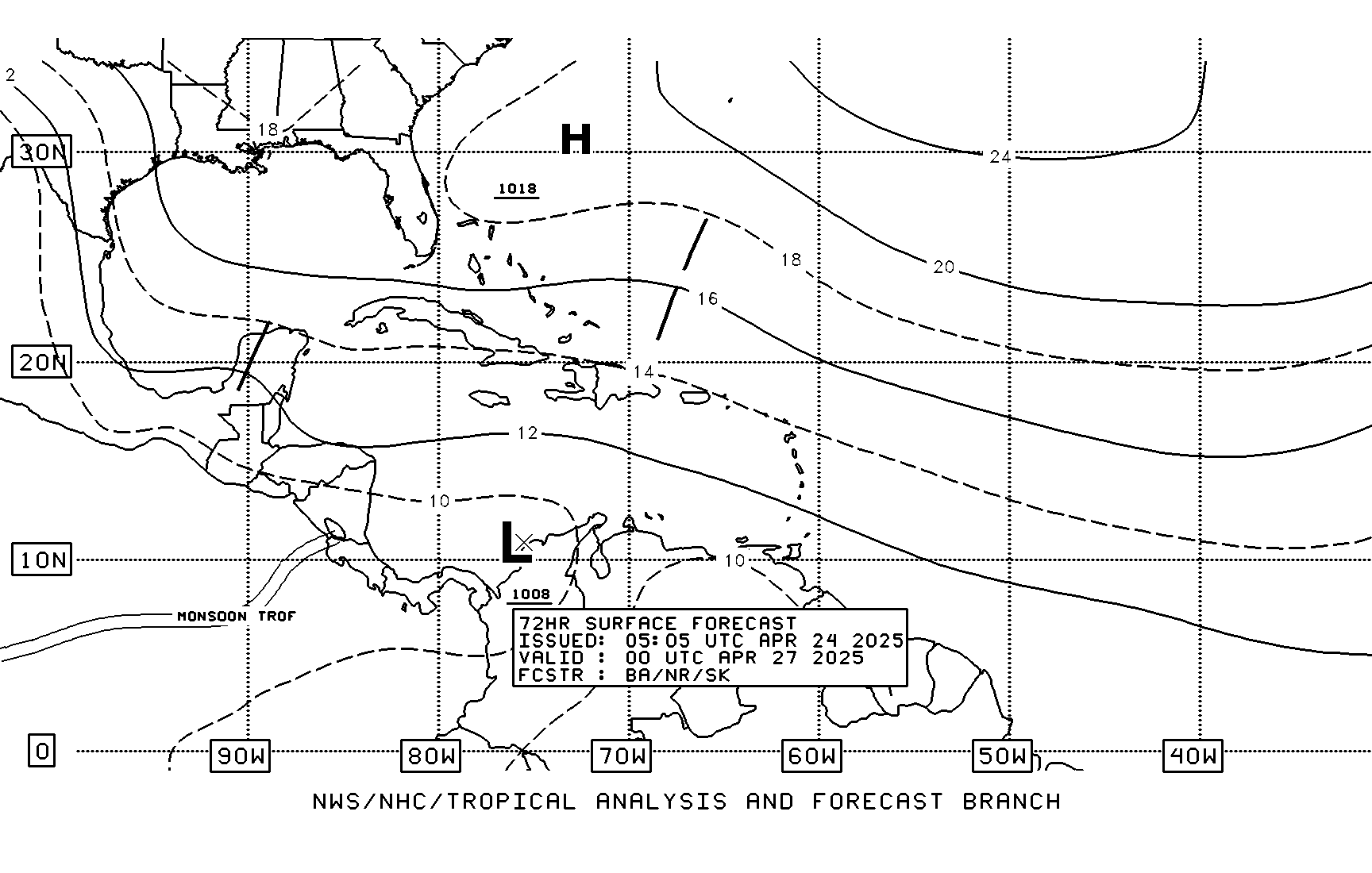
Latest 72 hour TAFB shows a tropical wave approaching the lesser antilles which is the farthest north I have seen a wave thus far this year.....this is probably the same wave with the noticeable circulation we all witnessed as it rolled off of Africa a couple of days ago.
Could this wave be the spark to create cyclogenesis in the SW Caribbean? Thoughts welcome

Could this wave be the spark to create cyclogenesis in the SW Caribbean? Thoughts welcome

0 likes
Excerpt from Miami NWS today:
THE FCST CONTINUES RATHER UNCERTAIN FOR LATE NEXT WEEK INTO NEXT
WEEKEND. GFS SHOWS ANOTHER SHORTWAVE DIVING SE INTO THE AREA...BUT
THE BULK OF IT STAYS TO OUR NORTHEAST. ECMWF DOES NOT SHOW THIS.
STILL...BOTH MODELS DO SHOW A SLOW INCREASE IN MOISTURE
BEGINNING THURSDAY AND CONTINUING INTO NEXT WEEKEND. GFS/ECMWF HAVE
BEEN CONSISTENT IN DEVELOPING A TROPICAL SYSTEM OVER THE WESTERN
CARIB...BUT HOW STRONG AND WHERE IT WOULD GO...IF EVEN ANYTHING
DEVELOPS...IS JUST WAY TOO FAR OUT TO TELL AT THIS TIME.
0 likes
Re: GFS (Western Caribbean) Early Season Development?
Wow, look at this. Almost 20 pages about.....nothing really.
This thread does have a purpose. It's about the fundamental American belief. The idea that when you wish upon a star, your dreams come true.
0 likes
Re: GFS (Western Caribbean) Early Season Development?
Zadok wrote:Wow, look at this. Almost 20 pages about.....nothing really.
This thread does have a purpose. It's about the fundamental American belief. The idea that when you wish upon a star, your dreams come true.
That was good.
0 likes
- lrak
- S2K Supporter

- Posts: 1770
- Age: 59
- Joined: Thu Jun 21, 2007 2:48 pm
- Location: Corpus Christi, TX
Re: GFS (Western Caribbean) Early Season Development?
http://polar.ncep.noaa.gov/waves/latest_run/wna_ecg.anim.gif this is a nice animation showing waves all week for my area and then the last few frames show my next opportunity.
Absolutely Zadok, got to wish for something,
http://www.youtube.com/watch?v=-7GQzmUNWXs&feature=related
and is this model based off the GFS?
Also hope for those big ones to keep South this year and run fast West like last year too, I hope my memory is thinking correctly.
Absolutely Zadok, got to wish for something,
http://www.youtube.com/watch?v=-7GQzmUNWXs&feature=related
and is this model based off the GFS?
Also hope for those big ones to keep South this year and run fast West like last year too, I hope my memory is thinking correctly.
0 likes
-
Ed Mahmoud
Re: GFS (Western Caribbean) Early Season Development?
I haven't checked the Japanese Met model on my AccuWx PPV site yet...
It says EPAC through Day 8, not particularly strong.
It says EPAC through Day 8, not particularly strong.
0 likes
-
Ed Mahmoud
Re: GFS (Western Caribbean) Early Season Development?
EastPac
MET OFFICE TROPICAL CYCLONE GUIDANCE FOR NORTH-EAST PACIFIC
AND ATLANTIC
GLOBAL MODEL DATA TIME 12UTC 24.05.2008
NEW TROPICAL STORM FORECAST TO DEVELOP AFTER 48 HOURS
FORECAST POSITION AT T+ 48 : 9.6N 94.8W
VERIFYING TIME POSITION STRENGTH TENDENCY
-------------- -------- -------- --------
12UTC 26.05.2008 9.6N 94.8W WEAK
00UTC 27.05.2008 8.7N 92.5W WEAK INTENSIFYING SLIGHTLY
12UTC 27.05.2008 8.4N 90.3W MODERATE INTENSIFYING RAPIDLY
00UTC 28.05.2008 8.9N 89.1W MODERATE INTENSIFYING SLIGHTLY
12UTC 28.05.2008 9.6N 89.2W STRONG LITTLE CHANGE
00UTC 29.05.2008 10.4N 90.1W STRONG LITTLE CHANGE
12UTC 29.05.2008 10.8N 91.0W INTENSE INTENSIFYING RAPIDLY
00UTC 30.05.2008 11.3N 91.5W INTENSE INTENSIFYING RAPIDLY
12UTC 30.05.2008 11.9N 91.6W INTENSE INTENSIFYING RAPIDLY
THIS INFORMATION IS PROVIDED AS GUIDANCE FOR TROPICAL CYCLONE
RSMCS. IT REQUIRES INTERPRETATION BY TROPICAL CYCLONE SPECIALISTS
AND SHOULD NOT BE CONSIDERED AS A FINAL PRODUCT
MET OFFICE, EXETER, UK
0 likes
18Z Nogaps looks interesting tonight. Favoring the GFS...
https://www.fnmoc.navy.mil/wxmap_cgi/cg ... rp&tau=144
https://www.fnmoc.navy.mil/wxmap_cgi/cg ... rp&tau=144
0 likes
Re: GFS (Western Caribbean) Early Season Development?
I wonder what causing the mesoscale complex in Central America in the Yucatan and surrounding areas.
http://www.ssd.noaa.gov/goes/east/watl/avn-l.jpg
http://www.ssd.noaa.gov/goes/east/watl/avn-l.jpg
0 likes
- wxman57
- Moderator-Pro Met

- Posts: 23127
- Age: 68
- Joined: Sat Jun 21, 2003 8:06 pm
- Location: Houston, TX (southwest)
Re: GFS (Western Caribbean) Early Season Development?
boca wrote:I wonder what causing the mesoscale complex in Central America in the Yucatan and surrounding areas.
http://www.ssd.noaa.gov/goes/east/watl/avn-l.jpg
Looks like a weak tropical wave axis passing south of the Yucatan. Can see it moving westward on the water vapor loop.
0 likes
- Category 5
- Category 5

- Posts: 10074
- Age: 35
- Joined: Sun Feb 11, 2007 10:00 pm
- Location: New Brunswick, NJ
- Contact:
Re: GFS (Western Caribbean) Early Season Development?
RL3AO wrote:Zadok wrote:Wow, look at this. Almost 20 pages about.....nothing really.
This thread does have a purpose. It's about the fundamental American belief. The idea that when you wish upon a star, your dreams come true.

That was good.
Good enough for my Motivational Poster series on -removed- in fact.
0 likes
-
Ed Mahmoud
Re: GFS (Western Caribbean) Early Season Development?
Even the 0Z GFS is in the East Pac now.
Good practice at spending time on the blog and looking at models anyway.

Good practice at spending time on the blog and looking at models anyway.

0 likes
Who is online
Users browsing this forum: No registered users and 176 guests


