[b]The posts in this forum are NOT official forecast and should not be used as such. They are just the opinion of the poster and may or may not be backed by sound meteorological data. They are NOT endorsed by any professional institution or storm2k.org. For official information, please refer to the NHC and NWS products.
http://weather.unisys.com/hurricane/atl ... index.html
Just to point out that we are having a "super" major midwest flood not unlike 1993. Also 1993 was one of the quitest seasons of the last few decades. http://en.wikipedia.org/wiki/June_2008_Midwest_floods
http://en.wikipedia.org/wiki/Iowa_flood_of_2008
http://en.wikipedia.org/wiki/Floods_in_ ... _1901-2000
Some years that had records that where broken or coming close...Also years that had a flood over the midwest.
1913
1978
1991
Further downstream in Elkader, the river crested in the morning on Tuesday June 10 at nearly 31 feet, besting the previous record set in 1991.
http://weather.unisys.com/hurricane/atl ... /track.gif 8 named storms.
1918
1927
http://weather.unisys.com/hurricane/atl ... /track.gif 7 named storms.
1937
http://weather.unisys.com/hurricane/atl ... /track.gif 9 named storms.
1945
http://weather.unisys.com/hurricane/atl ... /track.gif 11 named storms.
1951
http://weather.unisys.com/hurricane/atl ... /track.gif 10 named storms.
1965
http://weather.unisys.com/hurricane/atl ... /track.gif 6 named storms.
1977
http://weather.unisys.com/hurricane/atl ... /track.gif 6 named storms.
1983
http://weather.unisys.com/hurricane/atl ... /track.gif 4 named storms.
1993
http://weather.unisys.com/hurricane/atl ... index.html 8 named storms.
1997
http://weather.unisys.com/hurricane/atl ... /track.gif
Named storms 8 on this map and I believe a unnamed system. Making 9.
This has to do with a stream of moisture aimed at the midwest. This can have effects of more shear over the Gulf and western Atlantic, I believe. In affect hurting tropical cyclone development in these years. This year unlike 1997 is a La nina so I expect less shear over the centeral and Eastern Atlantic prviding the best activity over these area's. I expect this to be leaning towards 65% cape verde and 35% home grown activity. I also based on this data and because we have a La nina inside a active phase to be around 11-13 named storms overall as I forecasted earlier this year.
Years with a huge midwest flood to tropical activity.
Moderator: S2k Moderators
Forum rules

The posts in this forum are NOT official forecasts and should not be used as such. They are just the opinion of the poster and may or may not be backed by sound meteorological data. They are NOT endorsed by any professional institution or STORM2K. For official information, please refer to products from the National Hurricane Center and National Weather Service.
-
weatherwindow

- Category 4

- Posts: 904
- Joined: Mon Sep 20, 2004 9:48 am
- Location: key west/ft lauderdale
Re: Years with a huge midwest flood to tropical activity.
matt..lastest estimates indicate a good probability of the weak la nina fading to a sustained neutral thru the season...which, if any, of the listed years were neutral?...btw, thanks for the research......rich
0 likes

Re: Years with a huge midwest flood to tropical activity.
1993 we were in the middle of a prolonged El Nino event
0 likes
Re: Years with a huge midwest flood to tropical activity.
Interesting that almost all of those years (except for '45 and '65) were not very active at all when it came to tropical systems - perhaps many or all related to El Nino phases (as said in the earlier post, '93 was a prolonged El Nino event)...
As TWC mentioned, the shear across the Gulf and Caribbean is uncharacteristically strong for this time of year, since both are favored areas for early season development. Since we are not shown to be in an El Nino phase, this might increase the theories about Global Warming increasing shear across the tropics, unrelated to an El Nino event...
As one poster said on this board, one model shows 50 Kt shear across the Caribbean in the days ahead, something that in years past was not even seen during the Winter months...
0 likes

Frank, I think higher shear across the Caribbean is what normally happens in a La nina...think aobut why most la ninas don't get going till August and that alot of la ninas favor cape verde systems rather then home brew systems.
The overall basin shear is far more important for the season as a whole but higher shear in what is probably less then 25% of the whole basin is no proof of GW induced shear occuring.
The overall basin shear is far more important for the season as a whole but higher shear in what is probably less then 25% of the whole basin is no proof of GW induced shear occuring.
0 likes
-
'CaneFreak

- Category 5

- Posts: 1487
- Joined: Mon Jun 05, 2006 10:50 am
- Location: New Bern, NC
"As TWC mentioned, the shear across the Gulf and Caribbean is uncharacteristically strong for this time of year, since both are favored areas for early season development. Since we are not shown to be in an El Nino phase, this might increase the theories about Global Warming increasing shear across the tropics, unrelated to an El Nino event..."
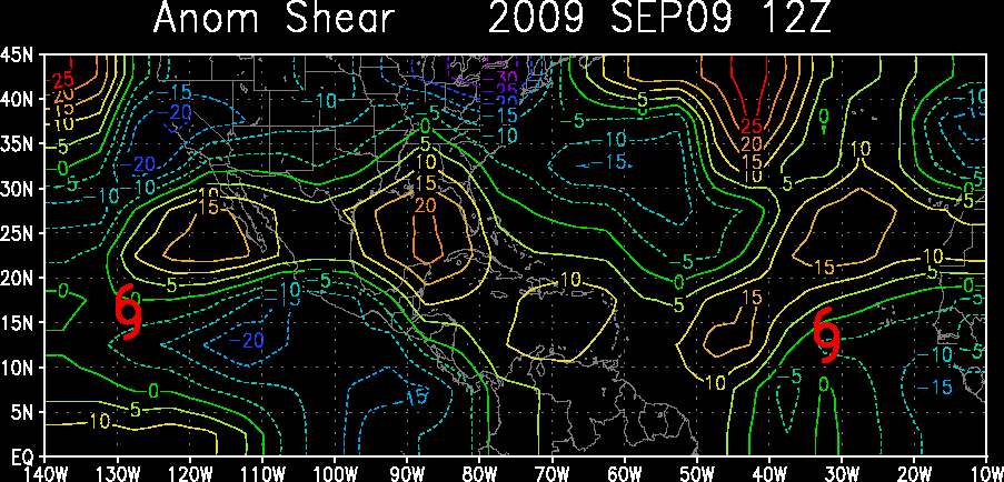
To prove that some of us do not know what in the heck we are talking about, here are the shear anomalies AS OF TODAY with the 30 to 40 knots of shear blowing around in the Carribean. GUESS WHAT? You are correct, but the exact opposite of what you said is true. The shear is uncharacteristically WEAK for this time of year. There should be 40-50 knots of shear blowing around in the Carribean but in reality there is only 30-40 knots at this very moment in time.
http://www.ssd.noaa.gov/PS/TROP/DATA/gparm/xyashr.gif
Oh and one other thing, the GFS that peers into the next two weeks in time does NOT SHOW 50 knots of 300 mb winds at any point in the Carribean or the Subtropical Atlantic for that manner. Go look yourself. I will even give you the link.
http://www.nco.ncep.noaa.gov/pmb/nwprod ... arib.shtml
Click on any run and you will see what I mean. In fact, in early July the GFS shows that upper level winds will go to a stand still.
0 likes
-
hurricanetrack

- HurricaneTrack.com
- Posts: 1781
- Joined: Tue Dec 02, 2003 10:46 pm
- Location: Wilmington, NC
- Contact:
Re: Years with a huge midwest flood to tropical activity.
Question:
What is today's date?
Answer: June 19
Any further questions? Send them to donotworrythehurricaneseasonisaliveandwell@yahoo.com
What is today's date?
Answer: June 19
Any further questions? Send them to donotworrythehurricaneseasonisaliveandwell@yahoo.com
0 likes
Yep hurricanetrack as you say we are still fairly early in the season we aren't going to get really low shear values probably for another month or two but as canefreak said the overall picture is we are decent below average, indeed across the Atlantic we have only been above average for a couple of days at a time then we go through a prolonged period of b elow normal shear.
0 likes
-
Derek Ortt
Re: Years with a huge midwest flood to tropical activity.
canefreak,
You might be correct, but, I'm just repeating what one of the veteran TWC OCM's mentioned on Tuesday morning (it was not Jim Cantore, by the way)...
Perhaps it's their new HD set - last night, they showed both OCM's standing in front of the big screens, but, they appeared so small, that they might as well have been at your house in NC - being in my 50's, my eyes are already complaining at having to squint to see these miniature OCM's, so, I'm constantly finding myself migrating to NBCWP, since they still use the "old technology", which is much easier on old eyes like mine...
I used to think that NBCWP was a bit behind TWC since WP is mostly rebroadcast material, but, now TWC is "off the air" between 11 p.m. - 4 a.m., so, it's now about the same when it comes to watching taped broadcasts...
Seriously, though, true that there is more shear with a La Nina (that's one reason for the severe weather), but, there is much debate now (including from NOAA) as to whether GW does increase shear in the tropics, so, I wouldn't be so quick to say we don't know what we are saying - the old rules of nature are being rewritten as we speak, due to serious changes in the Earth's climate, a result of man's constant and damaging "interaction"...
Frank
You might be correct, but, I'm just repeating what one of the veteran TWC OCM's mentioned on Tuesday morning (it was not Jim Cantore, by the way)...
As TWC mentioned, "...shear across the Gulf and Caribbean is uncharacteristically strong for this time of year, since both are favored areas for early season development."
Perhaps it's their new HD set - last night, they showed both OCM's standing in front of the big screens, but, they appeared so small, that they might as well have been at your house in NC - being in my 50's, my eyes are already complaining at having to squint to see these miniature OCM's, so, I'm constantly finding myself migrating to NBCWP, since they still use the "old technology", which is much easier on old eyes like mine...
I used to think that NBCWP was a bit behind TWC since WP is mostly rebroadcast material, but, now TWC is "off the air" between 11 p.m. - 4 a.m., so, it's now about the same when it comes to watching taped broadcasts...
Seriously, though, true that there is more shear with a La Nina (that's one reason for the severe weather), but, there is much debate now (including from NOAA) as to whether GW does increase shear in the tropics, so, I wouldn't be so quick to say we don't know what we are saying - the old rules of nature are being rewritten as we speak, due to serious changes in the Earth's climate, a result of man's constant and damaging "interaction"...
Frank
0 likes
-
OuterBanker
- S2K Supporter

- Posts: 1761
- Joined: Wed Feb 26, 2003 10:53 am
- Location: Nags Head, NC
- Contact:
This year is nothing like 1993 which was a prolonged event that lasted through August. This years flooding was bad, but for all intents and purposes it is over. We may get a few more tstorms in these areas, but nothing like the prolonged 93 event. Not to mention that we are in the waning days of a La Nina not El Nino. Shear this time of year is not all that rare for June, that is why this time of year is so void of storms traditionally. Global warming scare tacticians must choose another route since the past two years have been void of hurricane landfalls on the CONUS. So they comparing this years Midwest flooding to 1993 as an example. But I'm afraid that they will have plenty of fodder later because I think that this year will be a bad one for land falling hurricanes. Both Gulf and all of the east coast waters near the CONUS are above average which doesn't bode well. I think that this year will favor long tracking and close in development. One other thing, the MJO pulse will be favorable in a couple weeks. So my guess on Bertha is early July.
BTW, last year was actually cooler on earth than the year before
BTW, last year was actually cooler on earth than the year before
0 likes
Re: Years with a huge midwest flood to tropical activity.
After posting the above, I read Derek's comment:
I was always told the same by other meteorologists, and, was one reason I mentioned it - so, the TWC comment was correct in that strong shear across the Caribbean is uncharacteristic (my comments about their new HD set remain, however)...
As for what outerbanker said, true, the La Nina is in it's later stages, but, let's hope and pray that the season isn't what you think it might become...
Still, we are seeing constant EC troughs (unusual for an active stationary front to be across Central Florida on June 19), so, that long-wave pattern will have an affect on what might form to our east...
One last thing - it confounds me when many continue to deny the role that climate change (a/k/a GW) has on our Earth - Man's abuse of nature has been ongoing for centuries, but, especially since the Industrial Revolution, and, why many think this abuse would not have any consequence is hard to understand...
La nina favors lower shear over the Caribbean and more Caribbean development
El nino favors shear over the Caribbean. The Walker circulation is displaced to the east in a warm ENSO phase
I was always told the same by other meteorologists, and, was one reason I mentioned it - so, the TWC comment was correct in that strong shear across the Caribbean is uncharacteristic (my comments about their new HD set remain, however)...
As for what outerbanker said, true, the La Nina is in it's later stages, but, let's hope and pray that the season isn't what you think it might become...
Still, we are seeing constant EC troughs (unusual for an active stationary front to be across Central Florida on June 19), so, that long-wave pattern will have an affect on what might form to our east...
One last thing - it confounds me when many continue to deny the role that climate change (a/k/a GW) has on our Earth - Man's abuse of nature has been ongoing for centuries, but, especially since the Industrial Revolution, and, why many think this abuse would not have any consequence is hard to understand...
Last edited by Frank2 on Thu Jun 19, 2008 10:51 am, edited 1 time in total.
0 likes
Yep Franbk but its all about averages.
as someone else said we have had BELOW normal shear elvels in the Caribbean when we had a La Nina still present, though its come up in the last month or so as La Nina has decayed away. I don't actually like the way Derek words that IMO to use above and below normal would be a far more reflective of what is the case IMO. At this time of year 25-35kts which is pretty reflective of the area looking at this map here:
http://cimss.ssec.wisc.edu/tropic/real- ... g8shr.html
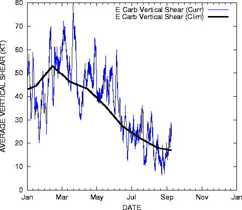
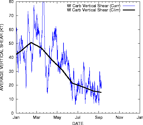
Now to clear up this once and for all take a look at this...this is shear compared to average across the Caribbean:
http://www.ssd.noaa.gov/PS/TROP/DATA/gparm/ecashr.gif
http://www.ssd.noaa.gov/PS/TROP/DATA/gparm/wcashr.gif
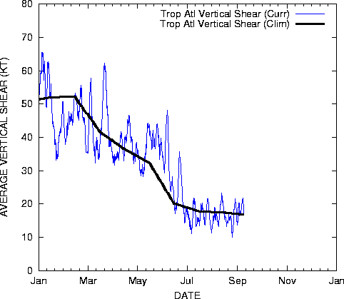
As you can see probably would average out across the Caribbean close to average over the past month. Also here is the tropical Atlantic shear levels:
http://www.ssd.noaa.gov/PS/TROP/DATA/gparm/tatshr.gif
Finally one last thing...we are not in a La Nina, we are now in a neutral phase which probably would favor close to normal shear levels which is what we are seeing.
as someone else said we have had BELOW normal shear elvels in the Caribbean when we had a La Nina still present, though its come up in the last month or so as La Nina has decayed away. I don't actually like the way Derek words that IMO to use above and below normal would be a far more reflective of what is the case IMO. At this time of year 25-35kts which is pretty reflective of the area looking at this map here:
http://cimss.ssec.wisc.edu/tropic/real- ... g8shr.html
Now to clear up this once and for all take a look at this...this is shear compared to average across the Caribbean:
http://www.ssd.noaa.gov/PS/TROP/DATA/gparm/ecashr.gif
http://www.ssd.noaa.gov/PS/TROP/DATA/gparm/wcashr.gif
As you can see probably would average out across the Caribbean close to average over the past month. Also here is the tropical Atlantic shear levels:
http://www.ssd.noaa.gov/PS/TROP/DATA/gparm/tatshr.gif
Finally one last thing...we are not in a La Nina, we are now in a neutral phase which probably would favor close to normal shear levels which is what we are seeing.
0 likes
-
vacanechaser

- Category 5
- Posts: 1461
- Joined: Wed Dec 03, 2003 9:34 pm
- Location: Portsmouth, Va
- Contact:
Re: Years with a huge midwest flood to tropical activity.
but, there is much debate now (including from NOAA) as to whether GW does increase shear in the tropics, so, I wouldn't be so quick to say we don't know what we are saying - the old rules of nature are being rewritten as we speak, due to serious changes in the Earth's climate, a result of man's constant and damaging "interaction"...
ok, i just have to jump in on this... didnt i read lately that GW has taken a break??? i mean they are all saying that the temp of the planet has not warmed since '98 and that the global temp has actually decreased... this as you guys like to say is "fact" .. all the global warming folks have said this lately.. if thats the case, then how is it possible that it is having this effect now with the shear... and if i is such a problem and causing this shear, why wouldnt have been in effect in ';05...
point i am making, its june... we are in transition to summer and a weakening la nina.. all of this would help lead me to believe that the atmosphere is in an upheavil right now and going through change due to these conditons, not GW...we do not get development this time of year... maybe once every other year... they due point that out as well on twc, "once every other year" ...
Jesse V. Bass III
http://www.vastormphoto.com
Hurricane Intercept Research Team
0 likes

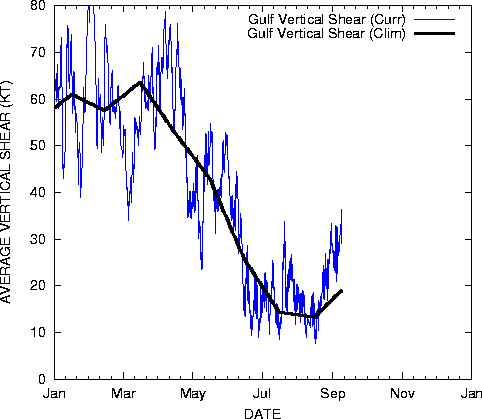
I would say that shear across the Caribbean has bear near or just below normal in average for the last 8 weeks or so. Nothing unusual for this time of the year, for the TWC to say that it is high for being a La Nina year is incorrect. GOM shear has actually being running below climatology since the end of May. Other La Nina years at this time of the year it has been as high or higher what they are currently are.
The last La Nina there was as strong or stronger shear across The Caribbean and GOM.


The last La Nina there was as strong or stronger shear across The Caribbean and GOM.
Last edited by NDG on Thu Jun 19, 2008 11:36 am, edited 1 time in total.
0 likes
From the looks of the data there weren't a la nina summer though that was neutral though we did breifly dip into very weak la nina status during the 00-01 winter it was long gone by the summer, do you have 2000 in that format as that would probably be a better reflection of how this year will likely turn out:
http://www.cpc.noaa.gov/products/analys ... ears.shtml
http://www.cpc.noaa.gov/products/analys ... ears.shtml
0 likes
Re: Years with a huge midwest flood to tropical activity.
Yeah, I should had used 2000 as an example, here it is:


0 likes
Who is online
Users browsing this forum: Dougiefresh, JoshwaDone, Ntxw and 24 guests