TC Bertha
Moderator: S2k Moderators
-
Scorpion

Re:
Scorpion wrote:I don't think the path is quite clear-cut yet... IMO climatology needs to be thrown out the window in this case. There hasn't been a TC forming this east in July since '96.. and that hit the East coast.
I tend to agree. There was a lot of talk here on Monday and Tuesday of how climatology would doom this system, yet here we are with a TS coming out of the CV stream near the ITCZ and continuing with a clear (albeit weak) structure.
Without recon and other certain measurement, we cannot be sure what conditions are in the area, but my guess is that we might be looking at a southside track on this (although the latest "wobbles" are showing more of a NW track to my eye).
OPEN QUESTION:
Is this showing a Cape Verde scenario starting this early?
0 likes

Re: Tropical Storm Bertha in East Atlantic
tailgater wrote:Nice Pic
http://www.esl.lsu.edu/webpics/goes/Sto ... est_lc.jpg
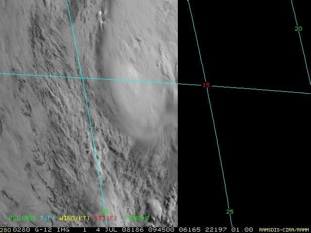
04/0545 UTC 14.5N 27.5W T3.0/3.0 BERTHA -- Atlantic Ocean
I'm still seeing a good NW jog on the wobble.... it could just be my eyes though.
She should get a floater shortly.
0 likes

Still looking good given its now over water around 25C, still bursting convection nicely as well still and if it can keep this up for the next 24-36hrs then its got every chance of making it to the warmer waters where stronger development is possible, esp if it can keep its shape. SAL clearly just off to the north and north-west so it needs to keep the convection going.
As for track, still westward right now I think, models that turn this system off to the NW though do really pick up the foward speed from this stage on and we shall have to see if that happen, if it doesn't then ther eis a chance its going to at least not get effected by it as much and the system will end up being a possible threat to Bermuda down the road.
As for track, still westward right now I think, models that turn this system off to the NW though do really pick up the foward speed from this stage on and we shall have to see if that happen, if it doesn't then ther eis a chance its going to at least not get effected by it as much and the system will end up being a possible threat to Bermuda down the road.
0 likes

This loop shows a clear west-northwest motion:
http://www.star.nesdis.noaa.gov/smcd/op ... loope.html
http://www.star.nesdis.noaa.gov/smcd/op ... loope.html
0 likes
-
HarlequinBoy

- Category 5

- Posts: 1400
- Age: 35
- Joined: Wed Nov 29, 2006 1:57 am
- Location: Memphis
000
WTNT42 KNHC 040859
TCDAT2
TROPICAL STORM BERTHA DISCUSSION NUMBER 5
NWS TPC/NATIONAL HURRICANE CENTER MIAMI FL AL022008
500 AM EDT FRI JUL 04 2008
A STRONG BURST OF DEEP CONVECTION BEGAN AT ABOUT 05Z...RESULTING IN
SUBJECTIVE DVORAK INTENSITY ESTIMATES AT 06Z OF 45-55 KT. THESE
ESTIMATES...HOWEVER...WERE CONTINGENT UPON THE LOW-LEVEL
CIRCULATION CENTER BEING LOCATED MUCH FARTHER NORTH THAN PREVIOUSLY
THOUGHT...AND RIGHT IN THE MIDDLE OF THE CONVECTION. PASSIVE
MICROWAVE IMAGES FROM TRMM AT 0146Z AND AMSR-E AT 0326Z SUGGEST THE
LOW-LEVEL CENTER HAS BEEN MOVING NORTH OF THE PREVIOUS MOTION
ESTIMATE...BUT BENEATH THE SOUTHERN PORTION OF THE COLD CLOUD TOP
CANOPY. SINCE 06Z...THE CLOUD TOPS HAVE WARMED A BIT...SO I DO
NOT THINK THE DVORAK ESTIMATES WOULD BE AS HIGH NOW. BEST I CAN
TELL FROM FIRST LIGHT VISIBLE IMAGES...THE LOW-LEVEL CENTER SEEMS TO
BE MOVING ALONG THE HEADING SUGGESTED BY THE MICROWAVE IMAGERY...OR
290/12... BENEATH THE SOUTHERN PORTION OF THE DEEP CONVECTION. THE
INITIAL INTENSITY WILL BE HELD AT 40 KT FOR NOW...TO SEE IF THE
DEEP CONVECTION PERSISTS AS BERTHA HEADS TOWARD SLIGHTLY COOLER
WATERS TODAY.
THE FORECAST REASONING HAS NOT CHANGED TOO MUCH. THE FIRST TWO DAYS
OF THE TRACK FORECAST HAVE BEEN ADJUSTED SLIGHTLY NORTHWARD...
MAINLY TO ACCOUNT FOR THE CHANGE IN THE INITIAL MOTION.
THEREAFTER...ONCE BERTHA FINDS ITSELF DUE SOUTH OF THE MID-LEVEL
RIDGE TO ITS NORTH...THE TRACK HAS BEEN SPED UP AND EDGED A LITTLE
TO THE LEFT OR WEST...IN ACCORDANCE WITH A WESTWARD SHIFT IN MOST
OF THE MODELS. ALL OF THE MODELS STILL FORECAST A WEAKNESS IN THE
RIDGE TO ALLOW BERTHA TO TURN TO THE RIGHT LATE IN THE FORECAST
PERIOD...BUT RECENT RUNS HAVE BEEN TRENDING TOWARD DELAYING THIS
TURN. THE NEW OFFICIAL TRACK FORECAST IS KEPT CLOSE TO THE MODEL
CONSENSUS...BUT THE MODEL SPREAD IS SUBSTANTIAL AT DAYS 4-5. THE
MODELS THAT FORECAST A STRONGER BERTHA...SUCH AS THE
GFDL...FORECAST MORE OF A NORTHWESTWARD MOTION BY DAY 5...WHILE
MODELS SUCH AS THE ECMWF AND UKMET INSIST ON A WEAKER CYCLONE
CONTINUING WEST-NORTHWESTWARD. THE OFFICIAL INTENSITY
FORECAST...LIKE THE TRACK FORECAST...IS CLOSE TO THE
CONSENSUS...TAKING A STRONG TROPICAL STORM DOWN THE MIDDLE OF THE
GUIDANCE ENVELOPE...IN CLOSEST AGREEMENT WITH THE LGEM GUIDANCE.
STRENGTHENING SHOULD BE LIMITED BY COOL WATERS DURING THE NEXT TWO
DAYS...AND BY INCREASING SHEAR ON DAYS 4 AND 5. IT IS NOTABLE THAT
THE GFDL AND HWRF INTENSITY FORECASTS ARE VERY MUCH IN
DISAGREEMENT...INDICATIVE OF GREAT UNCERTAINTY IN THE INTENSITY
FORECAST AS WELL.
FORECAST POSITIONS AND MAX WINDS
INITIAL 04/0900Z 14.2N 28.3W 40 KT
12HR VT 04/1800Z 15.0N 30.6W 45 KT
24HR VT 05/0600Z 15.9N 34.0W 45 KT
36HR VT 05/1800Z 16.6N 37.7W 50 KT
48HR VT 06/0600Z 17.3N 41.4W 55 KT
72HR VT 07/0600Z 19.0N 48.0W 60 KT
96HR VT 08/0600Z 21.5N 53.0W 60 KT
120HR VT 09/0600Z 25.0N 56.5W 60 KT
$$
FORECASTER KNABB
0 likes
The problem is Tropics the convection is on the NE side compared with yesterday when it was bang over most quadrants, this therefore may be making it looking its heading WNW infact its just a slight relocation of the convection further north whilst the center continues close to what it has been. IMO this may be heading back on a 285 track though but I'm not sure we shall have to wait for the NHC offical word.
0 likes

-
HURAKAN

- Professional-Met

- Posts: 46084
- Age: 39
- Joined: Thu May 20, 2004 4:34 pm
- Location: Key West, FL
- Contact:
Loop: http://rammb.cira.colostate.edu/product ... 030800.GIF
It looks pretty good in the look. The center is co-located with the area of convection. The intensity is probably in the range of 50-60 mph.
It looks pretty good in the look. The center is co-located with the area of convection. The intensity is probably in the range of 50-60 mph.
0 likes
-
Gustywind

- Category 5
- Posts: 12334
- Joined: Mon Sep 03, 2007 7:29 am
- Location: Baie-Mahault, GUADELOUPE
000
FXCA62 TJSJ 040722
AFDSJU
AREA FORECAST DISCUSSION
NATIONAL WEATHER SERVICE SAN JUAN PR
322 AM AST FRI JUL 4 2008
AS OF THIS LATEST FORECAST PACKAGE GENERATION...TROPICAL STORM
BERTHA IS CURRENTLY LOCATED ABOUT 185 MILES WEST-SOUTHWEST OF THE
SOUTHERNMOST CAPE VERDE ISLANDS AS PER LATEST NHC GUIDANCE. BASED
UPON THE LATEST MEDIUM-RANGE TRACK GUIDANCE...THE SYSTEM SHOULD
MAINTAIN A WEST-NORTHWEST TRACK. LATEST GFS SHOWS THE SYSTEM
EVENTUALLY MEANDERING 780 MILES TO THE NORTHEAST OF PUERTO RICO BY
11/1200Z. WHILE ITS PRECISE LOCATION WILL BE SUSPECT THIS FAR OUT
IN ADVANCE...IT IS IMPERATIVE THAT MARINERS...RESIDENTS...AND
TOURISTS MAINTAIN A WEATHER WATCH AND STAY TUNED TO THE LATEST
UPDATES FROM THE NATIONAL WEATHER SERVICE.
0 likes
-
StormTracker

- S2K Supporter

- Posts: 2909
- Age: 59
- Joined: Thu Jun 29, 2006 6:06 am
- Location: Quail Heights(Redlands), FL.
Re: Tropical Storm Bertha in East Atlantic
Happy 4th of July everybody!!!

Looks like the July fireworks might be starting early, with Bertha leading the pack!!!
Looks like the July fireworks might be starting early, with Bertha leading the pack!!!
0 likes
Convection has become a little more shallow now as we start to head through the daylight hours, this is to be somewhat expected mind you as these systems do tend to flare up and pulse down somewhat during the 24hrs of the day. Still looks decent enough:
http://www.ssd.noaa.gov/goes/east/catl/avn-l.jpg
Also if you look at wv you can see the are aof very high shear, the best chance is if this system stays to the south. It will still get hit by a strong region of shear for about 12-24hrs (really hefty shear at that) but once clear from that it reduces again quite a bit looking at current wv....of course thats assuming there isn't any major changes over the next week which is quite possible!
Also right now Bertha is a small compact system, wonder whether that has something to do with the low SST's as well?
0 likes
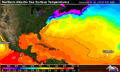

A little bit Hurakan but then again thats to be expected given the type of waters its over right now and so the convection won't be as impressive as it would be over warmer waters, the next 48hrs will be a good test of whether it can survive or not IMO. Once it reaches 40W the SST's start to increase again though after 96hrs the shear may start to increase as well. Going to have to wait and see.
0 likes
-
StormTracker
- S2K Supporter
- Posts: 2909
- Age: 59
- Joined: Thu Jun 29, 2006 6:06 am
- Location: Quail Heights(Redlands), FL.

Who is online
Users browsing this forum: No registered users and 37 guests