TC Bertha
Moderator: S2k Moderators

-
weatherguru18
Re: Hurricane Bertha in Western Atlantic
Bertha appears to be taking on more annular characteristics. Anybody else think so?
0 likes

Yeah that may well be the case, I've see recon before show these double eyewalls where the inner eyewall just won't collapse!
Hurakan, I'm not sure though I bet this may have a shot at the longest lasting July tropical cyclone in the north Atlantic. Emily tracked a long way as have a few others but this has the advantage of forming a good deal east of most of those.
Hurakan, I'm not sure though I bet this may have a shot at the longest lasting July tropical cyclone in the north Atlantic. Emily tracked a long way as have a few others but this has the advantage of forming a good deal east of most of those.
0 likes
-
HURAKAN

- Professional-Met

- Posts: 46084
- Age: 39
- Joined: Thu May 20, 2004 4:34 pm
- Location: Key West, FL
- Contact:
Re: Hurricane Bertha in Western Atlantic
Top 3:
BETSY 1965-08-27 18 days
BEULAH 1967-09-05 18 days
BONNIE 1992-09-17 16 days
Link: http://www.hurricaneville.com/longest_lasting.php
BETSY 1965-08-27 18 days
BEULAH 1967-09-05 18 days
BONNIE 1992-09-17 16 days
Link: http://www.hurricaneville.com/longest_lasting.php
0 likes


-
Cryomaniac
- Category 5

- Posts: 1289
- Joined: Tue Aug 15, 2006 2:26 pm
- Location: Newark, Nottinghamshire, UK
- Contact:
Re:
cheezyWXguy wrote:I dont know, im not a pro. But it looks like Bertha may be undergoing a transition to being an annular hurricane.
I thought that earlier, but didn't post it, partly because people tend to get angsty about anyone mentioning annular hurricanes.
Hurricanewatcher2007 wrote:Could Bertha become a problem for the US after all?
The following is the opinion of Cryomaniac, and is not backed by any evidence, meteorological, economic or otherwise. As such it should not be used for any purpose.
I seriously doubt it. I refuse to say it's impossible, because it isn't.
0 likes

-
Scorpion
-
MiamiensisWx
Re: Hurricane Bertha in Western Atlantic
The divergence from the upper low is providing excellent ascent and outflow along the western semicircle.
On another note, the outer (secondary) eyewall is steadily contracting, while a larger eye develops simultaneously and shrinks as well.
http://www.ssd.noaa.gov/goes/flt/t1/loop-ir2.html
On another note, the outer (secondary) eyewall is steadily contracting, while a larger eye develops simultaneously and shrinks as well.
http://www.ssd.noaa.gov/goes/flt/t1/loop-ir2.html
0 likes
Re: Hurricane Bertha in Western Atlantic
looks ok but last image shows holes in convection
you gotta think about upwelling over the next couple days (should model speed verify) this would inhibit her abit...ya
also appears northward motion may have taken a breather (but would need a few more images to confirm)
you gotta think about upwelling over the next couple days (should model speed verify) this would inhibit her abit...ya
also appears northward motion may have taken a breather (but would need a few more images to confirm)
0 likes

Re: Hurricane Bertha in Western Atlantic
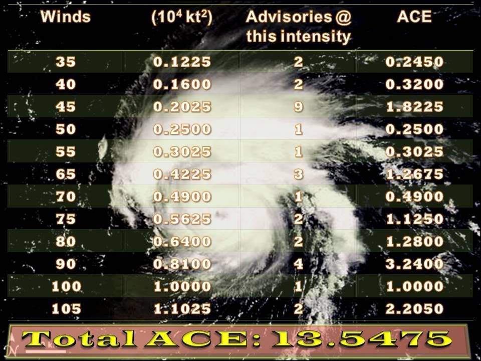
cycloneye wrote:ACE for Bertha continues to go up,now 13.915,the season in total is at 14.3:Code: Select all
Season total
Storm Type ACE (104 kt2)
01L (Arthur) Operational 0.3675
02L (Bertha) Operational 13.915
Total  14.2825
http://en.wikipedia.org/wiki/2008_Atlan ... ane_season
That's, again, wrong. Operationally it's 13.5475; best-track is 13.4125. Not 13.915.
0 likes


-
cycloneye

- Admin

- Posts: 149298
- Age: 69
- Joined: Thu Oct 10, 2002 10:54 am
- Location: San Juan, Puerto Rico
Re: Hurricane Bertha in Western Atlantic
No change from ATCF:
75 kts,980 mbs
AL, 02, 2008071100, , BEST, 0, 274N, 610W, 75, 980, HU, 64, NEQ, 25, 15, 15, 15, 1014, 200, 15, 0, 0,
75 kts,980 mbs
AL, 02, 2008071100, , BEST, 0, 274N, 610W, 75, 980, HU, 64, NEQ, 25, 15, 15, 15, 1014, 200, 15, 0, 0,
0 likes
Who is online
Users browsing this forum: No registered users and 42 guests