ATL: Tropical Depression Dolly
Moderator: S2k Moderators
Re: ATL: H Dolly in Western Gulf of Mexico
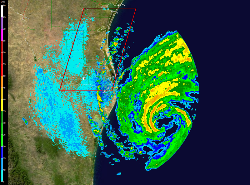
The eye is nice and round at low level but dirty higher up. Could be shear on it. Could be intensifiying - I'm not sure.
0 likes

-
MGC

- S2K Supporter

- Posts: 5940
- Joined: Sun Mar 23, 2003 9:05 pm
- Location: Pass Christian MS, or what is left.
Re: ATL: H Dolly in Western Gulf of Mexico
Dolly's radar and satellite presentations in the past couple of hours appear to indicate that the intensification trend has leveled off. Dry air appears to have become entrained into the hurricane's circulation from the south. The eyewall on the south and eastern side of the hurricane have appeared to have eroded by dry air from the south due to a ULL low to Dolly's south. The dry air is clearly evident on the WV satellite loop. The ULL to the south is also restricting outflow to the south. So, it looks like Dolly may have reached maxium intensity for now. Of course things can change quickly. Hopefully Dolly does not intensify more tonight. I think she has reached rock bottom.......MGC
0 likes
-
cheezyWXguy

- Category 5

- Posts: 6282
- Joined: Mon Feb 13, 2006 12:29 am
- Location: Dallas, TX
Re: ATL: H Dolly in Western Gulf of Mexico
Sanibel wrote:The eye is nice and round at low level but dirty higher up. Could be shear on it. Could be intensifiying - I'm not sure.
Not shear at all. Its only 80mph...what do you expect? The eye is just starting to clear out now, as a band is moving to the north of it. Organization is improving and it will likely continue to strengthen.
0 likes
-
HarlequinBoy

- Category 5
- Posts: 1400
- Age: 35
- Joined: Wed Nov 29, 2006 1:57 am
- Location: Memphis
-
cheezyWXguy
- Category 5
- Posts: 6282
- Joined: Mon Feb 13, 2006 12:29 am
- Location: Dallas, TX
Re: ATL: H Dolly in Western Gulf of Mexico
MGC wrote:Dolly's radar and satellite presentations in the past couple of hours appear to indicate that the intensification trend has leveled off. Dry air appears to have become entrained into the hurricane's circulation from the south. The eyewall on the south and eastern side of the hurricane have appeared to have eroded by dry air from the south due to a ULL low to Dolly's south. The dry air is clearly evident on the WV satellite loop. The ULL to the south is also restricting outflow to the south. So, it looks like Dolly may have reached maxium intensity for now. Of course things can change quickly. Hopefully Dolly does not intensify more tonight. I think she has reached rock bottom.......MGC
Nope I dont agree...what you are seeing is what is seen on every system as it approaches a coastline. The radar cant see through the heavy precipitation on the western side. I highly doubt this has leveled off...eye is just starting to show up on IR.
0 likes

Re: ATL: H Dolly in Western Gulf of Mexico
ROCK wrote:ULL to her NW is eating at her...see her flatten out on the NW...ULL to the SW restricting as well....trof digging in the plains.....she really is moving slow in the last few frames...
Yeah, I think that ULL is keeping the moisture from getting into central Texas - that would be a plus for us with this storm.
0 likes
Re: ATL: H Dolly in Western Gulf of Mexico
Less warm water nearer to coast. Trend would be slow continued intensification.
0 likes
-
fasterdisaster
- Category 5
- Posts: 1868
- Joined: Mon Sep 19, 2005 4:41 pm
- Location: Miami, Florida
Re: ATL: H Dolly in Western Gulf of Mexico
Sanibel wrote:Less warm water nearer to coast. Trend would be slow continued intensification.
Usually this only affects northward moving systems though, Dolly is westward so it shouldn't be a problem for her.
0 likes
-
alan1961

- Category 2

- Posts: 771
- Joined: Mon Mar 20, 2006 11:58 am
- Location: Derby, Derbyshire, England
- Contact:
Re: Re:
Ivanhater wrote:alan1961 wrote:KWT wrote:Yeah I'd like to see that as well Boca as I'm in the UK and don't have nearly quite the same TV options as some of you guys in the states have.
hsvwx, yeah its done a pretty decent job thus far, I think the NHC always say prepare for a category above, so in the as eof the offical NHC forecast, prepare for a high end cat-2 I think.
http://www.newslink.org/stattele.html
just 52 states to choose from there KWT
Now I know you Brits know we have 50 states!
ok go on then, i'll drop hawaii and alaska out of the contigous equation
0 likes
Re: ATL: H Dolly in Western Gulf of Mexico
This looks like a good one to chase. I hope TWC is there.
0 likes
-
JonathanBelles
- Professional-Met

- Posts: 11430
- Age: 35
- Joined: Sat Dec 24, 2005 9:00 pm
- Location: School: Florida State University (Tallahassee, FL) Home: St. Petersburg, Florida
- Contact:
Re: ATL: H Dolly in Western Gulf of Mexico
Sanibel wrote:This looks like a good one to chase. I hope TWC is there.
Theyve got two people including Cantore.
0 likes
-
cycloneye

- Admin

- Posts: 149338
- Age: 69
- Joined: Thu Oct 10, 2002 10:54 am
- Location: San Juan, Puerto Rico
Re: ATL: H Dolly in Western Gulf of Mexico
Sanibel wrote:This looks like a good one to chase. I hope TWC is there.
Cantore is in South Padre island.
0 likes

Re: ATL: H Dolly in Western Gulf of Mexico
Heavy rain about to start on shore. Also, the NE quadrant around the center has become better defined on radar.
0 likes
-
HarlequinBoy
- Category 5
- Posts: 1400
- Age: 35
- Joined: Wed Nov 29, 2006 1:57 am
- Location: Memphis


-
HarlequinBoy
- Category 5
- Posts: 1400
- Age: 35
- Joined: Wed Nov 29, 2006 1:57 am
- Location: Memphis
Re: ATL: H Dolly in Western Gulf of Mexico
That little eye at higher level in the eye is sometimes seen in storms doing intensification jerks. Or it's nothing.
0 likes
-
Weatherfreak14

- Category 5
- Posts: 1381
- Joined: Sat Sep 24, 2005 3:40 pm
- Location: Beaufort, SC
- Contact:
Who is online
Users browsing this forum: No registered users and 32 guests