RL3AO wrote:New VDM gives us a movement of 320.
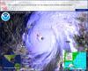
I live in the Rio Grande Valley, just wnw of BRO, and I just finished completing my hurricane preparations. Of course, as soon as I finished I took a gander at the 00z GFDL, which now has a landfall in NE Mexico about 30-50 miles south of BRO with a rapid turn to the west and wsw, ala the very consistent runs of the EURO, meaning that while we do get rain and some wind, the worst impacts will be south of Texas/Mexico border. In addition, I believe that there may be some evidence of a turn to the west-http://www.ssd.noaa.gov/goes/flt/t2/loop-ir2.html. This may be a wooble, or it may be the beginning of the west turn suggested by the GFDL and the previous runs of the EURO. Of course, while writing this post, I checked the 00z EURO which has landfall further north than most of its previous runs (i.e., right along the Tex./Mex. border. Please let me know your thoughts, as my wife and I are very concerned about potentially catastrophic flooding.