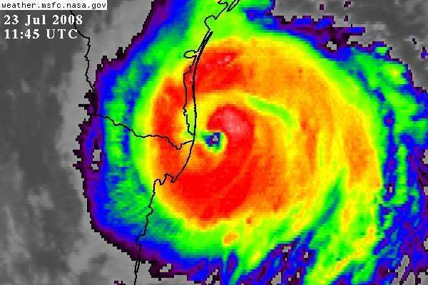
ATL: Tropical Depression Dolly

Moderator: S2k Moderators

Message
Author
paintplaye
Category 1
Category 1
Posts: 380
Joined: Sun Jul 20, 2008 11:25 pm

Re: Re:

#7361 Postby paintplaye » Wed Jul 23, 2008 6:58 am

ALhurricane wrote:
HURAKAN wrote:114630 2549N 09637W 6969 02855 9661 +147 +090 172010 012 000 005 03

extra: 966 mb


Dolly is certainly strengthening rather rapidly mow. IMO, NHC needs to upgrade at the next advisory.


COMON NWC UPDATE!!! We are even having pro mets say this. haha
0 likes   

HurricaneHunter914
Category 5
Category 5
Posts: 4439
Age: 31
Joined: Fri Mar 10, 2006 7:36 pm
Location: College Station, TX

#7362 Postby HurricaneHunter914 » Wed Jul 23, 2008 6:58 am

Looks like her eye is going to pass Brownsville at this rate. I hope she doesn't skirt the coast though. I think if she continues strengthening like this, she'll be a cat-2 of 95-100 mph by 10am.
0 likes   

User avatar
lrak
S2K Supporter
S2K Supporter
Posts: 1770
Age: 58
Joined: Thu Jun 21, 2007 2:48 pm
Location: Corpus Christi, TX

Re: ATL: H Dolly in Western Gulf of Mexico

#7363 Postby lrak » Wed Jul 23, 2008 7:00 am

Since this thing has passed Brownsville, where to next? I've got tape LOL on my monitor, not the most scientific way to show movement, but each piece of tape shows no westward movement, and the NHC graphic still shows it heading right for Brownville. Should Corpus really get ready now??
0 likes   

paintplaye
Category 1
Category 1
Posts: 380
Joined: Sun Jul 20, 2008 11:25 pm

Re: ATL: H Dolly in Western Gulf of Mexico

#7364 Postby paintplaye » Wed Jul 23, 2008 7:00 am

lrak wrote:Since this thing has passed Brownsville, where to next? I've got tape LOL on my monitor, not the most scientific way to show movement, but each piece of tape shows no westward movement, and the NHC graphic still shows it heading right for Brownville. Should Corpus really get ready now??


Dude i love the way you track storms.
0 likes   

User avatar
KWT
Category 5
Category 5
Posts: 31415
Joined: Tue Aug 17, 2004 11:02 am
Location: UK!!!

#7365 Postby KWT » Wed Jul 23, 2008 7:01 am

Wow extrap pressure of 966mbs, thats relaly low and it just proves that Dolly is for now undergoing RI, winds should catch up with the system asit makes landfall and that will probably the mean the highest winds founds by recon will be carried into land.
0 likes   

User avatar
hurricanefloyd5
Category 5
Category 5
Posts: 1659
Age: 44
Joined: Sun May 02, 2004 10:53 am
Location: Spartanburg
Contact:

Re:

#7366 Postby hurricanefloyd5 » Wed Jul 23, 2008 7:01 am

HurricaneHunter914 wrote:Looks like her eye is going to pass Brownsville at this rate. I hope she doesn't skirt the coast though. I think if she continues strengthening like this, she'll be a cat-2 of 95-100 mph by 10am.


If the winds start measering up with the mb Pressure then it shoul;d already be a Cat.2 maybe weak3!!!!!!!!!!But that is not happening!!!!!!!!!!!
0 likes   

User avatar
lrak
S2K Supporter
S2K Supporter
Posts: 1770
Age: 58
Joined: Thu Jun 21, 2007 2:48 pm
Location: Corpus Christi, TX

Re: ATL: H Dolly in Western Gulf of Mexico

#7367 Postby lrak » Wed Jul 23, 2008 7:02 am

paintplaye wrote:
lrak wrote:Since this thing has passed Brownsville, where to next? I've got tape LOL on my monitor, not the most scientific way to show movement, but each piece of tape shows no westward movement, and the NHC graphic still shows it heading right for Brownville. Should Corpus really get ready now??


Dude i love the way you track storms.


LMAO, I'm an accountant/broker...and I have you guys and gals to fill me in. I did get A's in science and math.
0 likes   

User avatar
HarlequinBoy
Category 5
Category 5
Posts: 1400
Age: 34
Joined: Wed Nov 29, 2006 1:57 am
Location: Memphis

Re: ATL: H Dolly in Western Gulf of Mexico

#7368 Postby HarlequinBoy » Wed Jul 23, 2008 7:02 am

lrak wrote:Since this thing has passed Brownsville, where to next? I've got tape LOL on my monitor, not the most scientific way to show movement, but each piece of tape shows no westward movement, and the NHC graphic still shows it heading right for Brownville. Should Corpus really get ready now??


Well I don't think it will make it that far up the coast, but hopefully CC residents have prepared a bit. There is a hurricane warning after all.
0 likes   

User avatar
HURAKAN
Professional-Met
Professional-Met
Posts: 46086
Age: 38
Joined: Thu May 20, 2004 4:34 pm
Location: Key West, FL
Contact:

#7369 Postby HURAKAN » Wed Jul 23, 2008 7:03 am

Image
0 likes   

Air Force Met
Military Met
Military Met
Posts: 4372
Age: 56
Joined: Tue Jul 08, 2003 9:30 am
Location: Roan Mountain, TN

Re: Re:

#7370 Postby Air Force Met » Wed Jul 23, 2008 7:03 am

ALhurricane wrote:
HURAKAN wrote:114630 2549N 09637W 6969 02855 9661 +147 +090 172010 012 000 005 03

extra: 966 mb


Dolly is certainly strengthening rather rapidly mow. IMO, NHC needs to upgrade at the next advisory.


That's an understatement.

But Avila has the seat..."No Data" Avila...

Sorry guys...getting very hard to hide my frustration...especially since I've been in on all the State and Fema calls that took this as no big deal because the NHC was only forecasting a 1.
0 likes   

User avatar
KWT
Category 5
Category 5
Posts: 31415
Joined: Tue Aug 17, 2004 11:02 am
Location: UK!!!

#7371 Postby KWT » Wed Jul 23, 2008 7:03 am

I think the NHC will probably be force dto upgrade it to category-2 een though winds probably only support a 80kts cat-1, still the pressure drop is just too large to ignore now I think.

Just hints that the western eyewall is opening up as it comes close to land now, Browns. is going to statrt really feeling high winds now...I'm guessing there must have been the odd hurricane force gust by now?
Last edited by KWT on Wed Jul 23, 2008 7:04 am, edited 1 time in total.
0 likes   

HurricaneHunter914
Category 5
Category 5
Posts: 4439
Age: 31
Joined: Fri Mar 10, 2006 7:36 pm
Location: College Station, TX

Re: Re:

#7372 Postby HurricaneHunter914 » Wed Jul 23, 2008 7:03 am

hurricanefloyd5 wrote:
HurricaneHunter914 wrote:Looks like her eye is going to pass Brownsville at this rate. I hope she doesn't skirt the coast though. I think if she continues strengthening like this, she'll be a cat-2 of 95-100 mph by 10am.


If the winds start measering up with the mb Pressure then it shoul;d already be a Cat.2 maybe weak3!!!!!!!!!!But that is not happening!!!!!!!!!!!

In an hour or so, the winds should catch up imo. She still has about 1-3 hrs over water.
0 likes   

User avatar
Innotech
Category 5
Category 5
Posts: 1031
Joined: Mon Aug 30, 2004 5:32 pm
Location: Lafayette, Louisiana
Contact:

Re: ATL: H Dolly in Western Gulf of Mexico

#7373 Postby Innotech » Wed Jul 23, 2008 7:03 am

Shes really bombing right now. This storm has defied all kinds of odds and my gut feeling has pretty much played out. All of you in the path, PLEASE HEED ALL PRECAUTIONS . Stay safe over there and live to track another day.
0 likes   

User avatar
lrak
S2K Supporter
S2K Supporter
Posts: 1770
Age: 58
Joined: Thu Jun 21, 2007 2:48 pm
Location: Corpus Christi, TX

Re: ATL: H Dolly in Western Gulf of Mexico

#7374 Postby lrak » Wed Jul 23, 2008 7:04 am

HarlequinBoy wrote:
lrak wrote:Since this thing has passed Brownsville, where to next? I've got tape LOL on my monitor, not the most scientific way to show movement, but each piece of tape shows no westward movement, and the NHC graphic still shows it heading right for Brownville. Should Corpus really get ready now??


Well I don't think it will make it that far up the coast, but hopefully CC residents have prepared a bit. There is a hurricane warning after all.


No one has boarded up, just picked up basic supplies so far.
0 likes   

User avatar
HURAKAN
Professional-Met
Professional-Met
Posts: 46086
Age: 38
Joined: Thu May 20, 2004 4:34 pm
Location: Key West, FL
Contact:

#7375 Postby HURAKAN » Wed Jul 23, 2008 7:04 am

URNT12 KNHC 231159
VORTEX DATA MESSAGE AL042008
A. 23/11:46:50Z
B. 25 deg 49 min N
096 deg 38 min W
C. 700 mb 2818 m
D. 59 kt
E. 132 deg 14 nm
F. 227 deg 074 kt
G. 131 deg 011 nm
H. 967 mb
I. 10 C/ 3045 m
J. 15 C/ 3041 m
K. 9 C/ NA
L. C20
M. CLOSED
N. 12345/7
O. 0.02 / 3 nm
P. AF302 1904A DOLLY OB 11
MAX FL WIND 86 KT NE QUAD 10:31:20 Z
MAX FL WIND OUTBOUND 78 KT NW QUAD 11:52:40 Z
0 likes   

User avatar
lrak
S2K Supporter
S2K Supporter
Posts: 1770
Age: 58
Joined: Thu Jun 21, 2007 2:48 pm
Location: Corpus Christi, TX

Re: ATL: H Dolly in Western Gulf of Mexico

#7376 Postby lrak » Wed Jul 23, 2008 7:05 am

It should of been 97W by now, WTH? Whats holding it out over the water?
Last edited by lrak on Wed Jul 23, 2008 7:06 am, edited 1 time in total.
0 likes   

paintplaye
Category 1
Category 1
Posts: 380
Joined: Sun Jul 20, 2008 11:25 pm

Re: ATL: H Dolly in Western Gulf of Mexico

#7377 Postby paintplaye » Wed Jul 23, 2008 7:06 am

lrak wrote:
paintplaye wrote:
lrak wrote:Since this thing has passed Brownsville, where to next? I've got tape LOL on my monitor, not the most scientific way to show movement, but each piece of tape shows no westward movement, and the NHC graphic still shows it heading right for Brownville. Should Corpus really get ready now??


Dude i love the way you track storms.


LMAO, I'm an accountant/broker...and I have you guys and gals to fill me in. I did get A's in science and math.


Haha i wish i could do that in math. Just duc-tape my desk. Measure shapes and figures that way. That would be so cool. Yea but i don't expect much more north than Brownsville.
0 likes   

User avatar
HURAKAN
Professional-Met
Professional-Met
Posts: 46086
Age: 38
Joined: Thu May 20, 2004 4:34 pm
Location: Key West, FL
Contact:

#7378 Postby HURAKAN » Wed Jul 23, 2008 7:06 am

HURRICANE DOLLY TROPICAL CYCLONE POSITION ESTIMATE
NWS TPC/NATIONAL HURRICANE CENTER MIAMI FL AL042008
700 AM CDT WED JUL 23 2008

AT 7 AM CDT THE CENTER OF HURRICANE DOLLY WAS ESTIMATED NEAR
LATITUDE 25.9 NORTH...LONGITUDE 96.8 WEST OR ABOUT 45 MILES...70
KM...EAST OF BROWNSVILLE TEXAS.

$$
FORECASTER AVILA
0 likes   

User avatar
KWT
Category 5
Category 5
Posts: 31415
Joined: Tue Aug 17, 2004 11:02 am
Location: UK!!!

#7379 Postby KWT » Wed Jul 23, 2008 7:06 am

967 from vortex, I think the NHC are going to have to up the winds now, een if its only to 80kts. By the way really impressive video just on fox news just now on SP island.

Still at the moment this is a powerful cat-1, everyone stay safe, the eyewall is going to be coming ashore in just a few hours, this hurricane will strengthen probably right upto landfall!
0 likes   

tracyswfla
S2K Supporter
S2K Supporter
Posts: 792
Joined: Tue May 18, 2004 1:19 pm
Location: Rochester, NY

Re: ATL: H Dolly in Western Gulf of Mexico

#7380 Postby tracyswfla » Wed Jul 23, 2008 7:07 am

Stay safe everyone!!
0 likes   


Return to “2008”

Who is online

Users browsing this forum: No registered users and 5 guests