ATL: Tropical Depression Fay
Moderator: S2k Moderators
-
storms in NC

- S2K Supporter

- Posts: 2338
- Joined: Thu Jul 28, 2005 2:58 pm
- Location: Wallace,NC 40 miles NE of Wilm
- Contact:

Re: ATL: Invest 92L - Central Atlantic
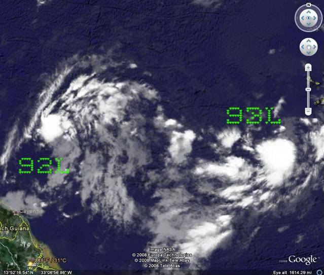
The convection is connected. It could be that 93 is stealing the energy from 92 and we'll see 93 form.
0 likes
-
storms in NC
- S2K Supporter
- Posts: 2338
- Joined: Thu Jul 28, 2005 2:58 pm
- Location: Wallace,NC 40 miles NE of Wilm
- Contact:

Re: ATL: Invest 92L - Central Atlantic
We could still see 92L form. As always, the systems are the best indicators of conditions. We could see favorability flash on and deeper convection form.
0 likes

Re: ATL: Invest 92L - Central Atlantic
Sanibel wrote:We could still see 92L form. As always, the systems are the best indicators of conditions. We could see favorability flash on and deeper convection form.
Sanibel remember on satelite last night it looked circular and it had good symmetry. Today its looks like a typical north/south wave.I don't think its going to develop and if it does I like my crow well done.
Last edited by boca on Mon Aug 11, 2008 9:23 am, edited 1 time in total.
0 likes
-
ConvergenceZone
.gif)
- Category 5

- Posts: 5241
- Joined: Fri Jul 29, 2005 1:40 am
- Location: Northern California
Re:
Derek Ortt wrote:may be time to start looking elsewhere... and even the system to the east is losing model support
Wow, I blew this one big time then..I thought for sure this would develop. Oh well. This season is a head scratcher for me, I just dont get it........Had the conditions been really bad around these waves I would have thought differently, but the conditions, although not perfect, weren't that bad....Perhaps my original prediction about it not getting going until the end of August or the beginning of September was right on afterall..... This is unbelievable....
Oh well........back to square one..... I think you are right about this Derek..
0 likes
-
deltadog03

- Professional-Met

- Posts: 3580
- Joined: Tue Jul 05, 2005 6:16 pm
- Location: Macon, GA
Re: ATL: Invest 92L - Central Atlantic
The NHC had this as a high probability of development too. What happened?
0 likes
-
Dean4Storms
- S2K Supporter
- Posts: 6358
- Age: 63
- Joined: Sun Aug 31, 2003 1:01 pm
- Location: Miramar Bch. FL
Re: ATL: Invest 92L - Central Atlantic
In Orlando this week and just today got a chance to get on the web to check out 92. Looks to me to be nothing more than a TW this am and I don't see any LLC that's for sure. Convection appears to be limited, but we see these pulses often out in the Atlantic with these Waves so I wouldn't write it off by any means at this point.
0 likes
-
deltadog03
- Professional-Met
- Posts: 3580
- Joined: Tue Jul 05, 2005 6:16 pm
- Location: Macon, GA
Re: ATL: Invest 92L - Central Atlantic
Conditions weren't like Dolly. There was no deep convection in the ITCZ to the south. The visible shot shows clear dry air to the south of 92L. That's a killer choke of dry air for a system needing a moist southern inflow. But August equatorial air isn't really "Dry". The only thing you can say is look for refire tonight during diurnal max.
I think 92L looks like 99L. Which is self-explanatory.
I think 92L looks like 99L. Which is self-explanatory.
0 likes
-
Extremeweatherguy

- Category 5
- Posts: 11095
- Joined: Mon Oct 10, 2005 8:13 pm
- Location: Florida
Re:
Yeah, once this gets closer to the islands it wouldn't surprise me to see a re-fire. Strong waves like this during mid August always need to be watched closely.deltadog03 wrote:I dunno boca....I am not saying its not going to develop, but its going to have to fight....Trouble is...once it gets near the islands, the pattern looks much more favorable...
0 likes
Re: ATL: Invest 92L - Central Atlantic
I can honestly say I don't know what 92L and 93L are going to do. Sanibel made a good point about the southerly inflow which is choking the system.I guess we might have to wait till 11pm or so tonight. 
0 likes
-
Ed Mahmoud
Re: ATL: Invest 92L - Central Atlantic
It had a closed circulation yesterday, but after intense staring, the low cloud swirl trailing the convection is gone, and while it seems to have a twist, low cloud elements just South of the convection do not have a West to East motion.
It is a tropical wave now.
6Z GFDL seems to have initialized it a tad too strong, but it maintains it near steady state, and keeps it just North of the Greater Antilles, so even if it doesn't develop today or tomorrow, it'll be a feature to watch, and by staying shallow, it may avoid the EC trough.

On the other hand, the 6Z GFDL sees shear getting more hostile in time...

OK, this post has some model stuff in it, but I think it is more of a discussion of the wave itself, not the models.
It is a tropical wave now.
6Z GFDL seems to have initialized it a tad too strong, but it maintains it near steady state, and keeps it just North of the Greater Antilles, so even if it doesn't develop today or tomorrow, it'll be a feature to watch, and by staying shallow, it may avoid the EC trough.
On the other hand, the 6Z GFDL sees shear getting more hostile in time...
OK, this post has some model stuff in it, but I think it is more of a discussion of the wave itself, not the models.
0 likes

12Z NAM
Appears a bit stronger this run towards the end with eyes set on the bahamas..
http://www.nco.ncep.noaa.gov/pmb/nwprod ... loop.shtml
Appears a bit stronger this run towards the end with eyes set on the bahamas..
http://www.nco.ncep.noaa.gov/pmb/nwprod ... loop.shtml
0 likes
-
alienstorm

- Category 1

- Posts: 496
- Joined: Tue Jul 31, 2007 1:29 pm
- Location: Miami Fla western suburb
Re: ATL: Invest 92L - Central Atlantic
If you look at High Resolution visible loop http://weather.msfc.nasa.gov/cgi-bin/post-goes
the actual mid level or low level circulation is east of the mass of clouds. Apparently it went thru some easterly shear and dry air intrusion and this cause the system to lose all identity. It will be interesting to see this afternoon how it progresses. It still seems to be fighting easterly shear.
the actual mid level or low level circulation is east of the mass of clouds. Apparently it went thru some easterly shear and dry air intrusion and this cause the system to lose all identity. It will be interesting to see this afternoon how it progresses. It still seems to be fighting easterly shear.
0 likes
Who is online
Users browsing this forum: No registered users and 10 guests