ATL: Tropical Depression Fay
Moderator: S2k Moderators
-
Derek Ortt
-
bvigal

- S2K Supporter

- Posts: 2276
- Joined: Sun Jul 24, 2005 8:49 am
- Location: British Virgin Islands
- Contact:
Re:
Yeah, that makes lots of sense to me. But, doesn't NHC see the same thing? Why the red circle? Is it because they expect the shear to drop?Meso wrote:bvigal, you're right about the dry air.But it's been a combination of both dry air and shear during the past 12 hours or so, as the system was heads into an area of some 30kt shear, which didn't look like it was going to last too long, one was able to see the cloud tops being ripped on the visible loops. Dry air has been a problem with this storm for a while and I have a feeling it will do a lot better once it passed the heaviest area of dry air, and into the lower shear.
0 likes
-
hurricanefloyd5

- Category 5

- Posts: 1659
- Age: 45
- Joined: Sun May 02, 2004 10:53 am
- Location: Spartanburg
- Contact:
Re: ATL: Invest 92L - Central Atlantic
I understand that models dose a flip flop but I still think even thought the models still flip flop that this storm still "COULD" hit florida but the question is where in FLORIDA (IF IT HITS FLORIDA) will it hit, south, central or north florida???????
0 likes
-
Blown Away

- S2K Supporter
- Posts: 10253
- Joined: Wed May 26, 2004 6:17 am
Re: ATL: Invest 92L - Central Atlantic
AREA FORECAST DISCUSSION
NATIONAL WEATHER SERVICE MELBOURNE FL
304 AM EDT TUE AUG 12 2008
.DISCUSSION...
WED ...UPPER TROUGH OVER NEW ENGLAND WILL CONTINUE TO PUSH EAST AS A DRY AIRMASS OVER THE MID ATLANTIC STATES PIVOTS EAST. THIS WILL PUSH THE SUBTROPICAL RIDGE OVER S FLORIDA AND AN AREA OF INCREASED MOISTURE AND SURFACE CONVERGENCE SETTLES ACROSS THE NORTH PART OF THE FORECAST AREA. THIS ALONG WITH A WESTERLY SURFACE FLOW WILL PILE THUNDERSTORMS ON THE FL EAST COAST RESULTING IN POPS 30 AND 40 POPS. DEEP MOISTURE WILL SLIDE NORTH BRIEFLY LATE WED AS A DEVELOPING LOW ALONG THE FRONT IN N FL WILL KICK OFF THE ATLANTIC COAST.
THU-SAT...RAIN CHANCES REMAIN ABOVE CLIMO AS RIDGE AXIS REMAINS TO THE SOUTH AND HIGH PWS COMBINED WITH MOSTLY WESTERLY SURFACE WINDS.
SUN-MON...BY SUNDAY A MORE EASTERLY FLOW SETS UP AND A SERIES OF WEAK EASTERLY WAVES PUSH THROUGH THE AREA SUNDAY AND MONDAY.
Talking about 92L
0 likes
-
storms in NC

- S2K Supporter
- Posts: 2338
- Joined: Thu Jul 28, 2005 2:58 pm
- Location: Wallace,NC 40 miles NE of Wilm
- Contact:
-
cycloneye

- Admin

- Posts: 149302
- Age: 69
- Joined: Thu Oct 10, 2002 10:54 am
- Location: San Juan, Puerto Rico
Re: ATL: Invest 92L - Central Atlantic
hurricanefloyd5 wrote:I understand that models dose a flip flop but I still think even thought the models still flip flop that this storm still "COULD" hit florida but the question is where in FLORIDA (IF IT HITS FLORIDA) will it hit, south, central or north florida???????
Way early to say about any area of Florida being at landfall if it does occur at all.
0 likes

Re: ATL: Invest 92L - Central Atlantic
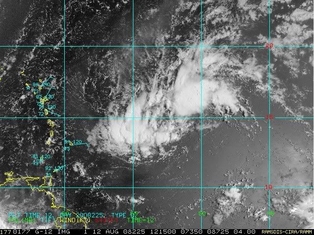
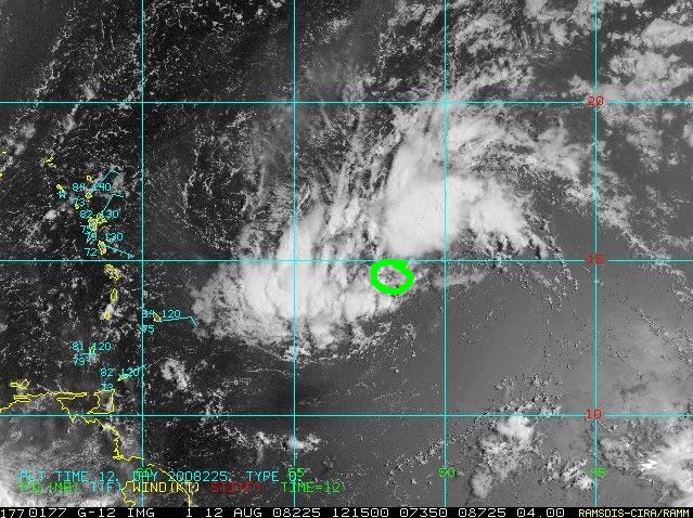
I agree with that circulation at 14N.
I think 14,5N/52,5W.
I think 14,5N/52,5W.
0 likes
-
Gustywind

- Category 5
- Posts: 12334
- Joined: Mon Sep 03, 2007 7:29 am
- Location: Baie-Mahault, GUADELOUPE
Re: ATL: Invest 92L - Central Atlantic
bvigal wrote:Well, I must admit to being totally confused now! We have a red circle from NHC. We have "too weak" for dvorak. We have different surface maps from different branches of NOAA. I think even the experts could honestly say "we really don't know what this will do".
http://www.nhc.noaa.gov/tafb_latest/WATL_latest.gif - (6z) moving almost due west, toward Guadeloupe, 1008 to 1007mb in 6hrs. Model guidance 6z puts motion at 325 degrees true! Look at that surface map arrow - NO WAY it's EVEN CLOSE to 325degrees.
Here's the most interesting thing I found this morning. Between this low and the islands, still a big wad of dry air, shown on precipitable water through 6z. Maybe it's this, not shear, that's hampering what would otherwise be expected development?

Good point bvigal
http://www.meteo.fr/temps/domtom/antill ... Tagant.jpg
Seems that's another round of soldid convection is occuring always on the southwestern peripheriphy of 92L...
0 likes

Re: ATL: Invest 92L - Central Atlantic
hurricanefloyd5 wrote:I understand that models dose a flip flop but I still think even thought the models still flip flop that this storm still "COULD" hit florida but the question is where in FLORIDA (IF IT HITS FLORIDA) will it hit, south, central or north florida???????
Not even a specialist from the NHC could answer that question.
0 likes
-
Gustywind
- Category 5
- Posts: 12334
- Joined: Mon Sep 03, 2007 7:29 am
- Location: Baie-Mahault, GUADELOUPE
Re: ATL: Invest 92L - Central Atlantic
OURAGAN wrote:I agree with that circulation at 14N.
I think 14,5N/52,5W.
Hi Ouragan, how are you?
I sent you a PM do you received it?
I'm agree with you there's maybe something in this area at 14,N 52,5W....
0 likes
-
Dean4Storms
- S2K Supporter
- Posts: 6358
- Age: 63
- Joined: Sun Aug 31, 2003 1:01 pm
- Location: Miramar Bch. FL
Re: ATL: Invest 92L - Central Atlantic
OURAGAN wrote:I agree with that circulation at 14N.
I think 14,5N/52,5W.
Right on, that is the circulation.
0 likes
-
carolina_73

- Tropical Storm

- Posts: 148
- Joined: Wed Jul 23, 2008 1:30 am
Re:
Derek Ortt wrote:the QUIKSCAT has the circulation near 14N, which is where the Dvorak estimates have had it
Is Quikscat showing a semi-closed circulation???
0 likes
-
HURAKAN

- Professional-Met

- Posts: 46084
- Age: 39
- Joined: Thu May 20, 2004 4:34 pm
- Location: Key West, FL
- Contact:
Loop: http://rammb.cira.colostate.edu/ramsdis ... _floater_1
The other loop I was watching didn't get me the whole picture.
The other loop I was watching didn't get me the whole picture.
0 likes
-
cheezyWXguy

- Category 5
- Posts: 6282
- Joined: Mon Feb 13, 2006 12:29 am
- Location: Dallas, TX
Re:
HURAKAN wrote:Loop: http://rammb.cira.colostate.edu/ramsdis ... _floater_1
The other loop I was watching didn't get me the whole picture.
I think the center is actually on the southern end of the large blob of convection. Thats where the low clouds are spiraling in to...why do people here think its a mlc? Is it because the sun is obscurring the low level clouds? I dont know if its closed or not but that is definitely at the surface.
0 likes
-
Hyperstorm

- Category 5
- Posts: 1500
- Joined: Sun Sep 07, 2003 3:48 am
- Location: Ocala, FL
Re: ATL: Invest 92L - Central Atlantic
The Weather Channel just got confirmation that the hurricane hunters will indeed be flying to this system this afternoon at 2pm. Meteorologist Nicole Mitchell has advised them that she will be on that flight.
To those that said that the NHC won't send planes east of 55W, that's not exactly true. Yes, there is a line there, but there's definitely been times in the past when they have reached the system between 50-55W.
To those that said that the NHC won't send planes east of 55W, that's not exactly true. Yes, there is a line there, but there's definitely been times in the past when they have reached the system between 50-55W.
0 likes
-
gatorcane

- S2K Supporter
- Posts: 23708
- Age: 48
- Joined: Sun Mar 13, 2005 3:54 pm
- Location: Boca Raton, FL
well 92L, if it develops, is what I kept warning about a couple of weeks ago when the discussions were around the persistent EC trough and how the pattern looked to be setting up for a season of recurves. I prefer to see a strong Bermuda High in June-July so that the long-wave pattern changes to troughiness for the heart of the season allowing for storms to recurve off the EC. But it does appear that a pretty solid H5 ridge is in the process of setting up off the EC which would block a recurve.
Not only that but here in South Florida I don't recall since I have lived here seeing persistent West to WSW winds for several weeks in a row (sometimes blowing in the 10-15mph range). We are not even getting East coast seabreezes to develop because of the strong troughiness. But I had a feeling this pattern had to change and it is in the process of changing for the active part of the Cape Verde season.
Not only that but here in South Florida I don't recall since I have lived here seeing persistent West to WSW winds for several weeks in a row (sometimes blowing in the 10-15mph range). We are not even getting East coast seabreezes to develop because of the strong troughiness. But I had a feeling this pattern had to change and it is in the process of changing for the active part of the Cape Verde season.
Last edited by gatorcane on Tue Aug 12, 2008 8:03 am, edited 2 times in total.
0 likes

-
Ed Mahmoud
Re: ATL: Invest 92L - Central Atlantic
My untrained eyes see a broad, almost elliptical circulation.
I'd imagine, if they wanted to, with the improved performance of the J model Hercules, they could get a decent amount of time inside 92L, but I also don't see the harm of waiting til dark thirty tonight and just flying the second scheduled mission.
I'd imagine, if they wanted to, with the improved performance of the J model Hercules, they could get a decent amount of time inside 92L, but I also don't see the harm of waiting til dark thirty tonight and just flying the second scheduled mission.
0 likes
Who is online
Users browsing this forum: No registered users and 58 guests