Reminds me a llittle of Jeanne. It won't likely become a hurricane before DR, also I expect it to move just north of the coastline.
I say based on surface data JMO it is a depression. We will see.
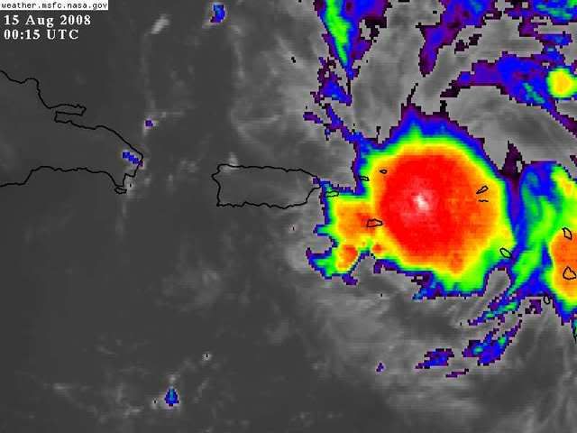
ATL: Tropical Depression Fay
Moderator: S2k Moderators

PR probably won't do anything to a system like this, its not organised and doesn't have a inner core so as long as convection keeps bursting then there isn;t an awful lot to disrupt. If it hits DR square on and stays over there for any amount of time well that may be a different matter but who knows.
Does look like the circulation at lower levels is finally underneath that big convective blob that blew up recently, should finally see some development start to occur soon I'd have thought.
Does look like the circulation at lower levels is finally underneath that big convective blob that blew up recently, should finally see some development start to occur soon I'd have thought.
0 likes
-
ConvergenceZone
.gif)
- Category 5

- Posts: 5241
- Joined: Fri Jul 29, 2005 1:40 am
- Location: Northern California
Re: ATL: Invest 92L in Western Atlantic
Well If this girl goes through or S of PR you can throw the models thus far out it seems and go with the ones with the more S guidance but then in 48hrs there may be nothing to look at?
Well, that's true that if it does go south and right through the meat of Puerto Rico and the mountainous land areas to the west, then this weekend there won't be anything left of this developing storm but an open wave, but of course flooding could claim many lives, so that's not a good thing either, but yet, it will keep this from developing that's for sure, especially since the conditions in the eastern gulf suppose to be fairly hostile...if on the other hand it was to go north of the islands, that could geat really dangerous too in terms of a potential very strong hurricane down the road....
Last edited by ConvergenceZone on Thu Aug 14, 2008 7:29 pm, edited 1 time in total.
0 likes
-
cheezyWXguy

- Category 5
- Posts: 6282
- Joined: Mon Feb 13, 2006 12:29 am
- Location: Dallas, TX
Re: Re:
SouthFLTropics wrote:RL3AO wrote:In my amateur opinion, I think there is a closed circulation just north of St. Croix.
IMHO it appears that 92L may be running out of time to get its act together before it plows into the first of the big islands. It better pull up soon or all the work that it has done to try and establish itself will be for nothing. As for me, I'm fine with that...92L can fall apart and go elsewhere. That being said, my prayers are with all of the peope in the Greater Antilles...As we all know even minor systems can cause major problems in that part of the world.
SouthFLTropics
Dont get your hopes up yet. It looks like its diving sw because thats the mlc moving toward the llc. Based on the movement of the LLC, it looks like it may barely skirt it, if at all. PR doesnt appear to be a huge problem with it...maybe 3 hours of slight disruption, but DR could be a bigger problem. However, if it continues on heading or just a tad bit north, then it will likely miss DR. That could be a very serious situation and it is all too real.
0 likes
Re: ATL: Invest 92L in Western Atlantic
a little off topic , but i wonder how many times the DR or Cuba has saved the SE Us from major hurricanes
0 likes


-
tolakram
- Admin

- Posts: 20183
- Age: 62
- Joined: Sun Aug 27, 2006 8:23 pm
- Location: Florence, KY (name is Mark)
Re: ATL: Invest 92L in Western Atlantic
need more buoys.

Personal Forecast Disclaimer:
The posts in this forum are NOT official forecast and should not be used as such. They are just the opinion of the poster and may or may not be backed by sound meteorological data. They are NOT endorsed by any professional institution or storm2k.org. For official information, please refer to the NHC and NWS products.
If you look at the loop it seems obvious to me that the convection has jumped over the LLC (or swirl that should become the LLC). I say a TD at 11 if not sooner, depending on how this new deep convection looks.
http://www.ssd.noaa.gov/goes/flt/t1/loop-avn.html
Last edited by tolakram on Thu Aug 14, 2008 7:31 pm, edited 1 time in total.
0 likes
Re: ATL: Invest 92L in Western Atlantic
I've been gone the last few hours. How are things looking? Are we still expecting development in the next 12-24 hours?
0 likes
-
ConvergenceZone
- Category 5
- Posts: 5241
- Joined: Fri Jul 29, 2005 1:40 am
- Location: Northern California
Re: ATL: Invest 92L in Western Atlantic
cpdaman wrote:a little off topic , but i wonder how many times the DR or Cuba has saved the SE Us from major hurricanes
good question, but I know that it's happened A LOT! I remember watching many canes basically get shredded apart by going over the islands. Of course if it's a decent hurricane, it usually generates someone after it emerges if the conditions support if, but if it's just a tropical storm of weak cane, it won't really have that chance...
EDIT: Please duplicate this accidental duplicate post. Thanks!
Last edited by ConvergenceZone on Thu Aug 14, 2008 7:33 pm, edited 1 time in total.
0 likes
-
cheezyWXguy
- Category 5
- Posts: 6282
- Joined: Mon Feb 13, 2006 12:29 am
- Location: Dallas, TX
Re:
HURAKAN wrote:
It now appears that the mlc and llc are extremely close to being stacked. They look to be within just a few miles of each other now. Maybe 2 or 3 more images before they are. I bet that theres a good chance that an upgrade may take place at 11. Anyone agree?
0 likes


-
Brent
- S2K Supporter

- Posts: 38734
- Age: 37
- Joined: Sun May 16, 2004 10:30 pm
- Location: Tulsa Oklahoma
- Contact:
Re: Re:
cheezyWXguy wrote:HURAKAN wrote:
It now appears that the mlc and llc are extremely close to being stacked. They look to be within just a few miles of each other now. Maybe 2 or 3 more images before they are. I bet that theres a good chance that an upgrade may take place at 11. Anyone agree?
I really think there may be an upgrade coming at 11 too. I keep checking here every few minutes for any signs.
0 likes

Re: ATL: Invest 92L in Western Atlantic
cpdaman wrote:a little off topic , but i wonder how many times the DR or Cuba has saved the SE Us from major hurricanes
or at least disrupted them.
I can quickly think of Ernesto (we call him the "leaf blower" down here in FL) and David.
David was fierce before it crossed Cuba and was significantly less dangerous when it grazed us down here.
0 likes

Re: ATL: Invest 92L in Western Atlantic
New satellite estimate.
14/2345 UTC 18.5N 63.0W T2.0/2.0 92L
14/2345 UTC 18.5N 63.0W T2.0/2.0 92L
0 likes
-
cycloneye

- Admin
- Posts: 149338
- Age: 69
- Joined: Thu Oct 10, 2002 10:54 am
- Location: San Juan, Puerto Rico
Re: ATL: Invest 92L in Western Atlantic
Best track position at 00z.
AL, 92, 2008081500, , BEST, 0, 183N, 646W, 30, 1011, DB, 34, NEQ, 0, 0, 0, 0, 1014, 150, 80,
AL, 92, 2008081500, , BEST, 0, 183N, 646W, 30, 1011, DB, 34, NEQ, 0, 0, 0, 0, 1014, 150, 80,
0 likes
-
Aric Dunn
- Category 5
- Posts: 21238
- Age: 43
- Joined: Sun Sep 19, 2004 9:58 pm
- Location: Ready for the Chase.
- Contact:
Re: ATL: Invest 92L in Western Atlantic
sgastorm wrote:New satellite estimate.
14/2345 UTC 18.5N 63.0W T2.0/2.0 92L
lol thats the midlevel circ...
0 likes
Who is online
Users browsing this forum: No registered users and 51 guests