ATL: Tropical Depression Fay
Moderator: S2k Moderators

Thats good news EJ at this stage, the further south it comes ashore the weaker it'll be...HOWEVER if its a well organised system we have seen hurricanes totally bomb out near the keys, ALA labor day hurricane, shouldn't expect that but the upper conditions are favorable so that even IF it does end up that far east it could do something impressive.
0 likes
-
Evil Jeremy

- S2K Supporter

- Posts: 5463
- Age: 32
- Joined: Mon Apr 10, 2006 2:10 pm
- Location: Los Angeles, CA
Re: ATL: Tropical Storm Fay
Don't know if this has been posted yet, but these are the thoughts from the NWS in SFL:
TROPICAL STORM FAY HAS FORMED OVER THE EASTERN DOMINICAN REPUBLIC
THIS AFTERNOON. FAY IS MOVING WEST-NORTHWEST AND IS EXPECTED TO REMAIN
ON A GENERAL TRACK ACROSS HISPANIOLA AND CUBA OVER THE NEXT DAY OR
TWO. THE OFFICIAL FORECAST TRACK INDICATES AN EVENTUAL NORTHWARD
TURN POSSIBLY BEGINNING ON SUNDAY, WHICH WOULD BRING THE CENTER OF
FAY OVER THE STRAITS OF FLORIDA OR EXTREME SOUTHEAST GULF OF
MEXICO LATE SUNDAY AND MONDAY.
THIS TRACK REPRESENTS A POSSIBLE THREAT TO PARTS OF SOUTH FLORIDA,
BUT IT IS IMPORTANT TO NOTE THAT FORECASTS AT LONGER TIME RANGES
ARE PRONE TO LARGE ERRORS IN TRACK AND INTENSITY DUE TO A HIGH
LEVEL OF UNCERTAINTY WITH THE EVOLVING WEATHER PATTERN OVER THE
REGION LATE THIS WEEKEND INTO EARLY NEXT WEEK. THEREFORE, IT IS
TOO EARLY TO INDICATE SPECIFIC HAZARDS AND IMPACTS FOR SOUTH
FLORIDA IN ASSOCIATION WITH FAY.
0 likes

Re: ATL: Tropical Storm Fay
Evil Jeremy wrote:Don't know if this has been posted yet, but these are the thoughts from the NWS in SFL:
TROPICAL STORM FAY HAS FORMED OVER THE EASTERN DOMINICAN REPUBLIC
THIS AFTERNOON. FAY IS MOVING WEST-NORTHWEST AND IS EXPECTED TO REMAIN
ON A GENERAL TRACK ACROSS HISPANIOLA AND CUBA OVER THE NEXT DAY OR
TWO. THE OFFICIAL FORECAST TRACK INDICATES AN EVENTUAL NORTHWARD
TURN POSSIBLY BEGINNING ON SUNDAY, WHICH WOULD BRING THE CENTER OF
FAY OVER THE STRAITS OF FLORIDA OR EXTREME SOUTHEAST GULF OF
MEXICO LATE SUNDAY AND MONDAY.
THIS TRACK REPRESENTS A POSSIBLE THREAT TO PARTS OF SOUTH FLORIDA,
BUT IT IS IMPORTANT TO NOTE THAT FORECASTS AT LONGER TIME RANGES
ARE PRONE TO LARGE ERRORS IN TRACK AND INTENSITY DUE TO A HIGH
LEVEL OF UNCERTAINTY WITH THE EVOLVING WEATHER PATTERN OVER THE
REGION LATE THIS WEEKEND INTO EARLY NEXT WEEK. THEREFORE, IT IS
TOO EARLY TO INDICATE SPECIFIC HAZARDS AND IMPACTS FOR SOUTH
FLORIDA IN ASSOCIATION WITH FAY.
Everyone from Alabama to NCarolina (and the Bahamas) should watch this very carefully...nothing is etched on stone right now
0 likes
-
m_ru
- Tropical Storm

- Posts: 136
- Age: 38
- Joined: Wed Aug 24, 2005 9:09 pm
- Location: Gautier, MS
- Contact:
Re: ATL: Tropical Storm Fay
If this baby tracks down the western side of the cone, Mississippi/Alabama are in TROUBLE! Loop current, loop current, LOOP CURRENT! Crap.
0 likes

Re: ATL: Tropical Storm Fay Pet and Wildlife Reactions
Well, if Winnie (dog) starts acting like she did in 2004 I'll let you know! She did the sniff the air thing and was all clingy too. When the storms got closer she would paw her ears. I guess the pressure change hurt.
0 likes
-
storms in NC

- S2K Supporter
- Posts: 2338
- Joined: Thu Jul 28, 2005 2:58 pm
- Location: Wallace,NC 40 miles NE of Wilm
- Contact:
We will see in the end. Well I still say it will move to the right more and ride the coast of east Fl and put to sea. Not up to NC. But this is JIMO
My daughter and brother live in Ft Myers So I do have interest in fl. Very much so. Just found out she is going to have a Baby that she was told she would never have. So I would be worried.
My daughter and brother live in Ft Myers So I do have interest in fl. Very much so. Just found out she is going to have a Baby that she was told she would never have. So I would be worried.
0 likes

Re: ATL: Tropical Storm Fay
[quote="hial2"
Everyone from Alabama to NCarolina (and the Bahamas) should watch this very carefully...nothing is etched on stone right now[/quote]
Yeah but they are not getting updates top of every hour on every local station like SoFla is....grin.
Serious side....I am very concerned about Haiti....highly deforested with a lot of rain....the potential for large casualties is quite acute.
0 likes
-
Evil Jeremy
- S2K Supporter
- Posts: 5463
- Age: 32
- Joined: Mon Apr 10, 2006 2:10 pm
- Location: Los Angeles, CA
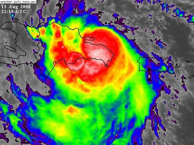
Cloud tops rising near the center as the sun goes down. Looks like it is heading 280 IMO.
http://www.ssd.noaa.gov/goes/flt/t1/loop-vis.html
http://www.ssd.noaa.gov/goes/flt/t1/loop-vis.html
0 likes


Re:
storms in NC wrote:We will see in the end. Well I still say it will move to the right more and ride the coast of east Fl and put to sea. Not up to NC. But this is JIMO
My daughter and brother live in Ft Myers So I do have interest in fl. Very much so. Just found out she is going to have a Baby that she was told she would never have. So I would be worried.
CONGRATS GRANDPA!! I'm sure nothing bad will happen and she'll be fine..Maybe you'll get a grandson who'll lead the Dolphins (or Panthers) to the Super Bown in 22 years or so..
0 likes
-
Weatherfreak14

- Category 5

- Posts: 1381
- Joined: Sat Sep 24, 2005 3:40 pm
- Location: Beaufort, SC
- Contact:
Re: ATL: Tropical Storm Fay
Soes it look like the Center is trying to drift to the north side of the convection or is it still S of DR???
0 likes
-
SouthFLTropics

- Category 5
- Posts: 4258
- Age: 50
- Joined: Thu Aug 14, 2003 8:04 am
- Location: Port St. Lucie, Florida
Re:
HURAKAN wrote:
Man, that pic almost looks like an utlrasound photo...Is Fay going to have a baby?
0 likes
Still south side of Dr, look at this radar, perfectly clear where the system is, looks like its aboiut 275 in terms of motion, roughly what its been all day:
http://www.onamet.gov.do/?s=web&p=1002
http://www.onamet.gov.do/?s=web&p=1002
0 likes
-
jaxfladude
- Category 5
- Posts: 1249
- Joined: Wed Aug 24, 2005 9:36 pm
- Location: Jacksonville, Fla
Re: Re:
SouthFLTropics wrote:HURAKAN wrote:
Man, that pic almost looks like an utlrasound photo...Is Fay going to have a baby?
She is having a she?
0 likes


Re: 92L Personal forecasts
The following post is NOT an official forecast and should not be used as such. It is just the opinion of the poster and may or may not be backed by sound meteorological data. It is NOT endorsed by any professional institution including storm2k.org For Official Information please refer to the NHC and NWS products.
Tropical Storm Fay Forecast #1
August 15, 2008

This forecast calls for a track slightly west of the current model consensus, taking Fay through the southern Dominican Republic into Central Haiti and weakening it into a depression, before it emerges back over open water on Saturday morning. Fay will spend the greater part of of the weekend skirting the southern coast of Cuba, allowing it to reach hurricane strength before making landfall near Cienfuegos around midnight EDT on Monday, and emerging into the southeastern Gulf of Mexico as a minimal hurricane or strong tropical storm on Monday morning.
Right now, I'm not even comfortable with guesses beyond 72 hours. At this point, any little unanticipated shift in direction can (and probably will) make a huge difference in both overall track as well as intensity. I, like everyone else, will probably have a better grip on this thing 24 hours from now, so I'll have another forecast up tomorrow, same bat-time, same bat-topic.
0 likes
'Is Fay going to have a baby?'
Fay is the growing baby.....
And finally.....NOAA49 has appeared-the G4.....maybe we can get some good upper air data into the models and stop them from looking like windshield wipers....back and forth...back and forth....or at least reduce the range...grin
FLIGHT THREE -- NOAA 49
A. 17/0000Z
B. NOAA9 11DDA CYCLONE
C. 16/1730Z
D. NA
E. NA
F. 41,000 TO 45,000 FT
0 likes

Re: ATL: Tropical Storm Fay Pet and Wildlife Reactions
dizzyfish wrote:Well, if Winnie (dog) starts acting like she did in 2004 I'll let you know! She did the sniff the air thing and was all clingy too. When the storms got closer she would paw her ears. I guess the pressure change hurt.
yours too dizzyfish? That is what I kind of thought as well, the pressure changes were affecting them. Let me know if she does, sthen it will be a shoo in up the east coast! To heck with forecasters! lol
0 likes
Who is online
Users browsing this forum: No registered users and 16 guests