
NDG wrote:Radar presention is looking better, Fay has really slowed down to a crawl relocating closer to the convection, a change is course is coming soon.
ATL: Tropical Depression Fay
Moderator: S2k Moderators

-
HurricaneHunter914
- Category 5

- Posts: 4439
- Age: 32
- Joined: Fri Mar 10, 2006 7:36 pm
- Location: College Station, TX
Re: Re:
Evil Jeremy wrote:HurricaneHunter914 wrote:I think it would help if we had a pro met tell us the heading. What a trooper Fay is. From looking terrible this morning, too looking very better organized this evening. IMO, even if Fay is heading NW or NNW, that area of Cuba is very mountanous and will probably have not too much of an affect.
The posts in this forum are NOT official forecast and should not be used as such. They are just the opinion of the poster and may or may not be backed by sound meteorological data. They are NOT endorsed by any professional institution or storm2k.org. For official information, please refer to the NHC and NWS products.
On the contrary, it will be passing through some of the flatter terrain of Cuba.
Sorry, should have fixed that. I meant not very mountanous.
0 likes
-
wxman57

- Moderator-Pro Met

- Posts: 23173
- Age: 68
- Joined: Sat Jun 21, 2003 8:06 pm
- Location: Houston, TX (southwest)
Re:
HurricaneHunter914 wrote:I think it would help if we had a pro met tell us the heading. ...snip
From what I can see, somewhere between just south of west to due north at from 6 to 18 mph. Does that help?
Seriously, Fay has such a poorly-defined center that there's just nothing to track to plot movement. That vortex we saw around noon today is gone. It moved west then south of west then expanded and went poof. The key to discerning Fay's movement is to watch which way that convective complex is moving over the long term. I've found that you can stand back and look at the big picture to get clues. See the image below. Note the pointed part of the outflow/outer band just west of southern Florida. I remember seeing the same thing with many storms, like Lili of 2002 pointing just where the storm was heading. The other arrows indicated upper-level winds across the Gulf as that trof digs down. Hard to imagine it tracking much west of the current forecast with that flow. And JB may have a point about his proposed track. I'm not ready to go for a cross Florida to the Carolinas yet, though.

0 likes

Re: ATL: Tropical Storm Fay South of Cuba
I have a question. Why does part of the SE coast of Fl still have a hurricane watch when they've teken this area out of the cone?
0 likes

Re: ATL: Tropical Storm Fay South of Cuba
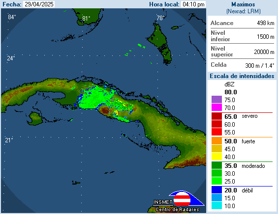
Just looking at the latest 7:00PM radar image from Cuba. Wanted to get feedback is the center A or B on the image I drew up below? or is not either?
Never mind just saw the new image....
Never mind just saw the new image....
Last edited by blp on Sun Aug 17, 2008 6:35 pm, edited 3 times in total.
0 likes
Re: ATL: Tropical Storm Fay South of Cuba
Normandy wrote:The center isn't moving because its being pulled into the deep convection to the east. The whole mass itself is still moving but the center was so far displaced earlier that it gives the illusion of a stall. If Fay puts her center completely under deep convection I'd venture to say it might get close to cane status before hitting Cuba.
thank you. this is all i was saying, but some didn't see this i think
long nite ahead, NHC track looks good, but nothing is etched in stone, and they admit still lots of uncertainty
0 likes
-
Evil Jeremy

- S2K Supporter

- Posts: 5463
- Age: 32
- Joined: Mon Apr 10, 2006 2:10 pm
- Location: Los Angeles, CA
-
eastcoastFL

- Category 5
- Posts: 3996
- Age: 44
- Joined: Thu Apr 12, 2007 12:29 pm
- Location: Palm City, FL
Re: ATL: Tropical Storm Fay South of Cuba
hellow st. lucie neighbor. Fay is looking a lot better this evening.
0 likes
-
Emmett_Brown

- Category 5
- Posts: 1433
- Joined: Wed Aug 24, 2005 9:10 pm
- Location: Sarasota FL
Re: ATL: Tropical Storm Fay South of Cuba
NEXRAD wrote:TS Fay will continue moving WNW to NW until the system deepens. Being a weak, more shallow, tropical storm, Fay is currently under influence of easterly winds that extend from the surface with more east-southeast to south-east winds extending from H95 to around H70. In the mid-levels (H50) the steering winds are almost due south. Therefore, as Fay strengthens, the storm will become more influenced by southerly flow aloft, which would turn the storm northward. If the storm strengthens quicker than forecast, then an earlier turn would take place. Conversely, more delayed strengthening would lead to a farther west tracking storm - assuming that the system maintains a forward motion. Certainly in the complex steering regime a slowed forward motion, or stall, is possible.
- Jay
Thanks Jay! Last few frames of the radar show her wrapping up... might even be an eye like clear area taking shape. (not an eye yet obviously, but wrapping all around.) I agree in your theory that the surge W/NW was the center being carried by the low level flow.
Orginization trend continuing...
0 likes

Re: ATL: Tropical Storm Fay South of Cuba
Ive noticed a few ppl have mentioned that Fay seems to be slowing down. If this were the case, what would result if Fay moved slower than predicted?
0 likes

Agreed wxman57 i think the current forecast is about right from the NHC i see no reason really why it would go west of where it is forecasted unless the turn take a little longer.
Also I think the whole thing is moving probably WNW but on the northern side of that heading however we have a LLC that over the last 4hrs hasn't relaly gained much if any latitude, still around 20.9N.
I'm willing to bet however that LLC takes a sharp NW turn soon, indeed the center is probably now getting deeper and better organised under the deep convection.
0 likes
-
Evil Jeremy
- S2K Supporter
- Posts: 5463
- Age: 32
- Joined: Mon Apr 10, 2006 2:10 pm
- Location: Los Angeles, CA

-
AJC3

- Admin

- Posts: 4153
- Age: 62
- Joined: Tue Aug 31, 2004 7:04 pm
- Location: Ballston Spa, New York
- Contact:
Re: ATL: Tropical Storm Fay South of Cuba
lbvbl wrote:Ive noticed a few ppl have mentioned that Fay seems to be slowing down. If this were the case, what would result if Fay moved slower than predicted?
Nope, I just think it's a function of the system making an attempt at getting better organized.
0 likes
-
AdamFirst

- S2K Supporter
- Posts: 2490
- Age: 36
- Joined: Thu Aug 14, 2008 10:54 am
- Location: Port Saint Lucie, FL
Re: ATL: Tropical Storm Fay South of Cuba
sunnyday wrote:I have a question. Why does part of the SE coast of Fl still have a hurricane watch when they've teken this area out of the cone?
The Southeast Coast is under a Tropical Storm Watch, and it's because depending on the track and size of the storm the east coast can see TS conditions.
0 likes
-
cycloneye

- Admin
- Posts: 149410
- Age: 69
- Joined: Thu Oct 10, 2002 10:54 am
- Location: San Juan, Puerto Rico
Re: ATL: Tropical Storm Fay South of Cuba
000
URNT12 KNHC 172336
VORTEX DATA MESSAGE AL062008
A. 17/23:08:50Z
B. 20 deg 57 min N
080 deg 03 min W
C. 850 mb 1445 m
D. 24 kt
E. 200 deg 32 nm
F. 290 deg 025 kt
G. 201 deg 046 nm
H. 1002 mb
I. 17 C/ 1465 m
J. 19 C/ 1445 m
K. 16 C/ NA
L. NA
M. NA
N. 1345/8
O. 0.02 / 1 nm
P. AF302 1306A FAY OB 20
MAX FL WIND 40 KT SE QUAD 21:53:30 Z
Pressure down to 1002 mbs.
0 likes
Who is online
Users browsing this forum: No registered users and 63 guests