ATL: Tropical Depression Fay

Moderator: S2k Moderators

Message
Author
Clipper96

Re: ATL: Tropical Storm Fay South of Cuba

#7421 Postby Clipper96 » Sun Aug 17, 2008 11:44 pm

GreenSky wrote:
Matt-hurricanewatcher wrote:Fay has never seen a mountain that she would not climb. In she is doing so as the radar shows her core of turning moving right into it. It is turning northward now.
Great! Fay should not be anything more than a tropical storm when it hits SW Florida because she will have less time over water and will be SEVERELY DISRUPTED by land interaction with that central Cuban mountain range!
IMO, that's a very pessimistic estimate. My impression is that Fay will hardly weaken at all since Cuba is very skinny and, aside from the one mountain of Pico San Juan, very flat where Fay is crossing.

Judging from Key West radar, the center - still looking very much like a small eyewall to me - appears to have passed Pico San Juan, and is now tapping into northeasterly surface inflow uninhibited by terrain for, arguably, the first time since east of Puerto Rico. I speculate so based upon a darker band of green forming and pointing off northeast in the last twenty minutes.
0 likes   

Matt-hurricanewatcher

Re: ATL: Tropical Storm Fay South of Cuba

#7422 Postby Matt-hurricanewatcher » Sun Aug 17, 2008 11:45 pm

GreenSky wrote:There is a 3,000 foot mountain to its north. That is a mountain even where I'm. Sorry!!!


Matt, so do you agree with what I said? That 3,000 mountain should prevent Fay from ever becoming a hurricane before reaching SW Florida, right?[/quote]


I think it is a very real possiblity that it won't be a hurricane if the new gfs, Ecmwf turns out to be right. But I would think that the NC landfall that might happen it could be.
0 likes   

cpdaman
Category 5
Category 5
Posts: 3131
Joined: Sat Jun 10, 2006 11:44 am
Location: SPB county (gulf stream)

Re: ATL: Tropical Storm Fay South of Cuba

#7423 Postby cpdaman » Sun Aug 17, 2008 11:45 pm

man look at that key west radar......she is on a mission

http://radar.weather.gov/ridge/radar.ph ... 1&loop=yes

The posts in this forum are NOT official forecast and should not be used as such. They are just the opinion of the poster and may or may not be backed by sound meteorological data. They are NOT endorsed by any professional institution or storm2k.org. For official information, please refer to the NHC and NWS products.[/quote]

i would wager a small fortune that s fl goes under a tropical storm warning soon
0 likes   

User avatar
Extremeweatherguy
Category 5
Category 5
Posts: 11095
Joined: Mon Oct 10, 2005 8:13 pm
Location: Florida

Re: Re:

#7424 Postby Extremeweatherguy » Sun Aug 17, 2008 11:46 pm

funster wrote:
AdamFirst wrote:
funster wrote:Agree with @Sanibel that Fay is still moving NW on the NHC track. It is not suddenly headed off to the North - that's just the convection expanding in the storm as Fay continues to get better organized.


http://radar.weather.gov/radar.php?rid= ... 1&loop=yes

You can't say that doesn't look significant going over Cuba right now.


It's the convection around Fay expanding. It's not Fay crossing Cuba.
Funster, you don't know that for a fact. Yes, you may very well be right, but you just never know. Let's wait and see what RECON finds first. If they don't find anything south of Cuba, then it is a good bet that Fay is inland. Hopefully we will know the answer soon.
0 likes   

User avatar
SouthFLTropics
Category 5
Category 5
Posts: 4258
Age: 50
Joined: Thu Aug 14, 2003 8:04 am
Location: Port St. Lucie, Florida

Re:

#7425 Postby SouthFLTropics » Sun Aug 17, 2008 11:46 pm

HURAKAN wrote:
pojo wrote:
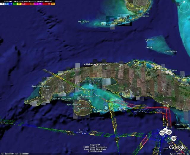
Because Fay is impacting Cuba, we have a 'storm' clearance meaning we can get inside of the 32NM Cuban ADIZ (32NM is the cushion set up from the US Gov't). We were talking with Havana Center while we were flying yesterday... and so is today's aircraft.


Image

Cuba is giving permission for the plane to fly over their airspace. That was the last AF RECON plotted. Another mission is getting closer to Cuba.


Thank you to the Castro's for this permission...The people of the United States...and in particular Florida...appreciate it. :flag:

SFT
0 likes   

NEXRAD
Category 1
Category 1
Posts: 370
Joined: Fri Jul 22, 2005 12:05 am
Location: South Florida

Re: ATL: Tropical Storm Fay South of Cuba

#7426 Postby NEXRAD » Sun Aug 17, 2008 11:47 pm

On the shortwave-IR you can see some nice banding features better forming.

- Jay
0 likes   

User avatar
Extremeweatherguy
Category 5
Category 5
Posts: 11095
Joined: Mon Oct 10, 2005 8:13 pm
Location: Florida

#7427 Postby Extremeweatherguy » Sun Aug 17, 2008 11:47 pm

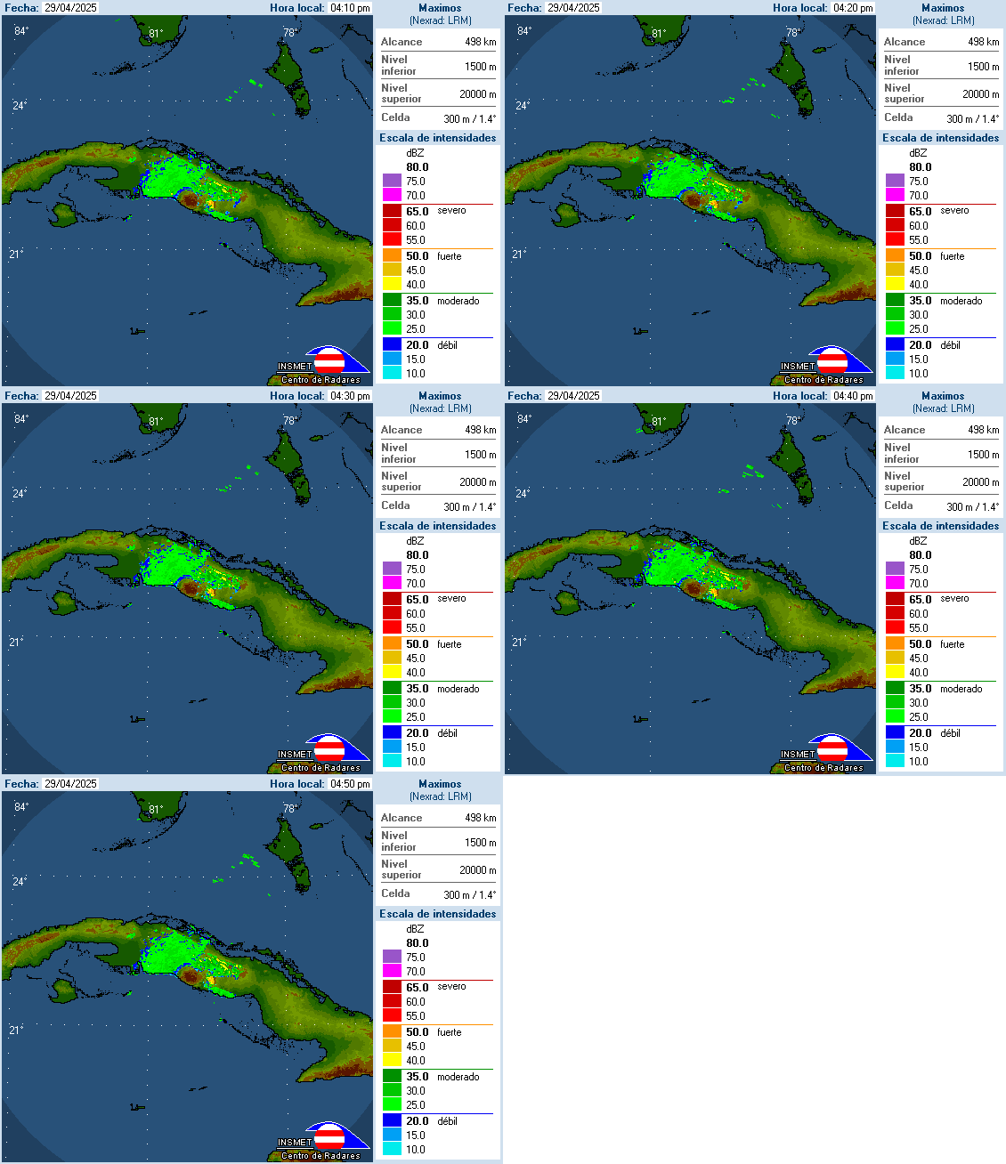
Cuban Radar...

Image
0 likes   

GreenSky
Tropical Storm
Tropical Storm
Posts: 109
Joined: Mon Aug 11, 2008 8:34 pm
Location: Land of Alex Jones!-Austin,TX

Re: ATL: Tropical Storm Fay South of Cuba

#7428 Postby GreenSky » Sun Aug 17, 2008 11:49 pm

Matt-hurricanewatcher wrote:
GreenSky wrote:There is a 3,000 foot mountain to its north. That is a mountain even where I'm. Sorry!!!


Matt, so do you agree with what I said? That 3,000 mountain should prevent Fay from ever becoming a hurricane before reaching SW Florida, right?


I think it is a very real possiblity that it won't be a hurricane if the new gfs, Ecmwf turns out to be right. But I would think that the NC landfall that might happen it could be.[/quote]

So Southwest Florida does not have that much to worry about besides heavy rains/flooding, isolated tornadoes, and sporadic power outages. Kinda like strong summer thunderstorm activity
0 likes   

User avatar
AdamFirst
S2K Supporter
S2K Supporter
Posts: 2490
Age: 36
Joined: Thu Aug 14, 2008 10:54 am
Location: Port Saint Lucie, FL

#7429 Postby AdamFirst » Sun Aug 17, 2008 11:49 pm

On the infrared satellite on the NHC site it looks like the new convection is trying to swallow the old over near Camaguey and such :lol:
0 likes   

User avatar
NDG
S2K Supporter
S2K Supporter
Posts: 15507
Joined: Sun Jul 09, 2006 10:14 pm
Location: Orlando, FL

#7430 Postby NDG » Sun Aug 17, 2008 11:50 pm

After looking at IR2 loop, to me Fay looks to be still moving NW, with its LLC close to 21.8N & 80.8W
0 likes   

User avatar
funster
Category 3
Category 3
Posts: 818
Joined: Sat Dec 29, 2007 4:27 pm
Location: North Dallas

Re: Re:

#7431 Postby funster » Sun Aug 17, 2008 11:50 pm

Extremeweatherguy wrote:
funster wrote:
AdamFirst wrote:http://radar.weather.gov/radar.php?rid= ... 1&loop=yes

You can't say that doesn't look significant going over Cuba right now.


It's the convection around Fay expanding. It's not Fay crossing Cuba.
Funster, you don't know that for a fact. Yes, you may very well be right, but you just never know. Let's wait and see what RECON finds first. If they don't find anything south of Cuba, then it is a good bet that Fay is inland. Hopefully we will know the answer soon.


That's true. But if I'm wrong and Fay is already moving N and crossing Cuba then the forecast has been badly botched.
0 likes   

Scorpion

#7432 Postby Scorpion » Sun Aug 17, 2008 11:50 pm

Certainly looks to be cranking up. If Cuba wasn't there I would think a Cat 2 would be possible.
0 likes   

Clipper96

#7433 Postby Clipper96 » Sun Aug 17, 2008 11:51 pm

The Cuban radars are very delayed.
Everybody should switch to the Key West one now.

http://radar.weather.gov/radar.php?rid= ... Z&loop=yes
0 likes   

User avatar
AdamFirst
S2K Supporter
S2K Supporter
Posts: 2490
Age: 36
Joined: Thu Aug 14, 2008 10:54 am
Location: Port Saint Lucie, FL

Re: Re:

#7434 Postby AdamFirst » Sun Aug 17, 2008 11:52 pm

funster wrote:That's true. But if I'm wrong and Fay is already moving N and crossing Cuba then the forecast has been badly botched.


NHC already claimed poor confidence in the track on the 11 PM discussion.
Last edited by AdamFirst on Sun Aug 17, 2008 11:52 pm, edited 1 time in total.
0 likes   

User avatar
MGC
S2K Supporter
S2K Supporter
Posts: 5936
Joined: Sun Mar 23, 2003 9:05 pm
Location: Pass Christian MS, or what is left.

Re: ATL: Tropical Storm Fay South of Cuba

#7435 Postby MGC » Sun Aug 17, 2008 11:52 pm

Fay's low level center has been on the western edge of the main convection for a while now. I still think the LLC is over the ocean. Fay is still being sheared by the ULL to its west which has prevented Fay from becoming vertically aligned. The apparent circulation as seen by Key West radar is likely displaced a good ways from the surface circulation. Fay still appears to be moving to the WNW to NW this evening. We shall see what recon finds. As Fay remains an poorly organized TS, it would not be surprising if Fay reforms its center sometime tonight under the deep convection. If this were to occur than Fay could ride up the spine of Florida. IMO, this would be the best case as Fay would remain a weak TS as it passes through the Keys.....MGC

Of course the above is MGC opinion and not an official forecast.
0 likes   

User avatar
southerngale
Retired Staff
Retired Staff
Posts: 27418
Joined: Thu Oct 10, 2002 1:27 am
Location: Southeast Texas (Beaumont area)

#7436 Postby southerngale » Sun Aug 17, 2008 11:53 pm

OT but I think it's pretty neat that we tied the record earlier tonight (about 8:30pm cdt). Just ONE more person and we would have broken it. And Fay is only a TS.


In total there are 654 users online :: 177 registered, 13 hidden and 464 guests
Most users ever online was 654 on Fri Aug 17, 2007 1:04 pm

Registered users: 1awsomez, 29healb, 93superstorm, AdamFirst, Agua, ai9d, Air Force Met, AJC3, AL Chili Pepper, ALhurricane, AnnularCane, Bane, beaufort12, BensonTCwatcher, Bgator, BigBeep, bikerbabe, Blown_away, boca, Bocadude85, BocaGirl, Brent, browhow, CajunMama, CalmBeforeStorm, Canelaw99, caneman, canes04, canetracker, cape_escape, caribepr, catastrophic, Category 5, Chacor, chris_fit, cind52, coreyl, cottoncloud, cpdaman, CrazyC83, Cyclenall, cycloneye, d4rays, DAPPBG, Dean4Storms, deltadog03, Derek Ortt, DESTRUCTION5, dixiebreeze, dlandry, dmaui, doingitall, dolebot_Broward_NW, driver633, Ed Mahmoud, Evil Jeremy, ExBailbonds, Extremeweatherguy, fact789, fci, Flakeys, flstorms, Frank P, gatorcane, gboudx, GeneratorPower, gginnola, Gigsley, Google [Bot], Ground_Zero_92, gtalum, heartland15, hial2, HurricaneBelle, hurricanedude, HurricaneQueen, Hurricanewatcher2007, HurryKane, inda_iwall, Ivanhater, Ixolib, jacindc, Jason_B, jaxfladude, jdray, JSDS, k4sdi, Kludge, KWT, LaBreeze, lebron23, LeeJet, Lowpressure, LSU2001, LSue, magwitch, mathwhizz, Matt-hurricanewatcher, maxx9512, MBismyPlayground, melhow, MGC, MHurricanes, miaka036, MiamiensisWx, Mississippi Storm Magnet, MississippiHurricane, MS39047, mufasa157, Myersgirl, NativeFloridaGirl, NEXRAD, ninel conde, Noles2006, notgroovy, O Town, Okibeach, Over my head, Pasco, pavelbure224, Pearl River, Philly12, quaqualita, rainydaze, RevDodd, RichardSmith, richartm, rjoniceguy, Robjohn53, ROCK, ronjon, Sabanic, Sanibel, Scorpion, Scott Patterson, scotto, sfwx, shah8, Shockwave, SimplyHavingFun, Sissy, sittingduck, sloar98rock, SoupBone, southerngale, southerngreen, SouthFLTropics, southmdwatcher, srainhoutx, Steve Cosby, Steve H., Storm Contractor, Stormhunter27, stormie, storms in NC, Stratusxpeye, stu, superfly, sweetpea, swimaster20, SWLASTORMTRACKER, tampastorm, temujin, tgenius, THead, tigergirl, Timedrifter, TMT, tolakram, Toyota Thundra, TropicalJon, VeniceInlet, Vex Rizor, Vortex, waterdog, wayne56, Weatherboy1, Weatherfreak14, weatherSnoop, WeatherWiseGuy, westcoastfl, windycity, Wx_Warrior, wxman57, wxmann_91, wxwonder12, wzrgirl1, x-y-no, Yahoo [Bot], zeeman66
0 likes   

NEXRAD
Category 1
Category 1
Posts: 370
Joined: Fri Jul 22, 2005 12:05 am
Location: South Florida

Re: ATL: Tropical Storm Fay South of Cuba

#7437 Postby NEXRAD » Sun Aug 17, 2008 11:53 pm

GreenSky wrote:
Matt-hurricanewatcher wrote:
So Southwest Florida does not have that much to worry about besides heavy rains/flooding, isolated tornadoes, and sporadic power outages. Kinda like strong summer thunderstorm activity


I'd think it to be fair to compare a Category 1 hurricane's impacts to a prolonged severe thunderstorm (without the hail or lightning). That mentioned, one difference between a thunderstorm and a hurricane is the long-duration of the winds. Constant winds can cause more damage than brief, isolated, wind gusts that are of a stronger magnitude based on my comparison of the damages from Charley and Frances across East Central Florida.

- Jay
0 likes   

Sanibel
Category 5
Category 5
Posts: 10385
Joined: Mon Aug 30, 2004 11:06 pm
Location: Offshore SW Florida

Re: ATL: Tropical Storm Fay South of Cuba

#7438 Postby Sanibel » Sun Aug 17, 2008 11:55 pm

I have to sleep in case I need to evacuate tomorrow. Those who stay up for reconnaissance I think you'll be surprised how close this comes to the NHC track.

Should be interesting tomorrow when I sign back on.
0 likes   

HurricaneHunter914
Category 5
Category 5
Posts: 4439
Age: 32
Joined: Fri Mar 10, 2006 7:36 pm
Location: College Station, TX

#7439 Postby HurricaneHunter914 » Sun Aug 17, 2008 11:58 pm

It seems like this storm really likes to get going right before making landfall. I believe that Fay will only remain a strong TS at this rate if she only strengthens right before landfall.
0 likes   

User avatar
Evil Jeremy
S2K Supporter
S2K Supporter
Posts: 5463
Age: 32
Joined: Mon Apr 10, 2006 2:10 pm
Location: Los Angeles, CA

Re:

#7440 Postby Evil Jeremy » Sun Aug 17, 2008 11:58 pm

southerngale wrote:OT but I think it's pretty neat that we tied the record earlier tonight (about 8:30pm cdt). Just ONE more person and we would have broken it. And Fay is only a TS.


We tied the record that was set one year to the day lol.
0 likes   


Return to “2008”

Who is online

Users browsing this forum: No registered users and 57 guests