http://cimss.ssec.wisc.edu/tropic2/real ... midshr.GIF
Shear is pretty much gone.
ATL GUSTAV: Tropical Depression - Discussion
Moderator: S2k Moderators
-
Blown Away

- S2K Supporter

- Posts: 10253
- Joined: Wed May 26, 2004 6:17 am
Re: ATL: Tropical Storm Gustav in Central Caribbean Sea
Is Gus moving a little S of W or is all the deep convection dying off towards the S?
http://www.ssd.noaa.gov/goes/flt/t1/loop-avn.html
http://www.ssd.noaa.gov/goes/flt/t1/loop-avn.html
0 likes
-
Derek Ortt
Re: ATL: Tropical Storm Gustav in Central Caribbean Sea
RL3AO wrote:latemodel25 wrote:so good possibility gustav might fizzle out?
No. Not really.
you know full well there is a chance this won't make it. It does not have any model support and I'm not about to forecast dissipation, but given the shearit will have o endure for another 12-24 hours, there is at least a 10% chance
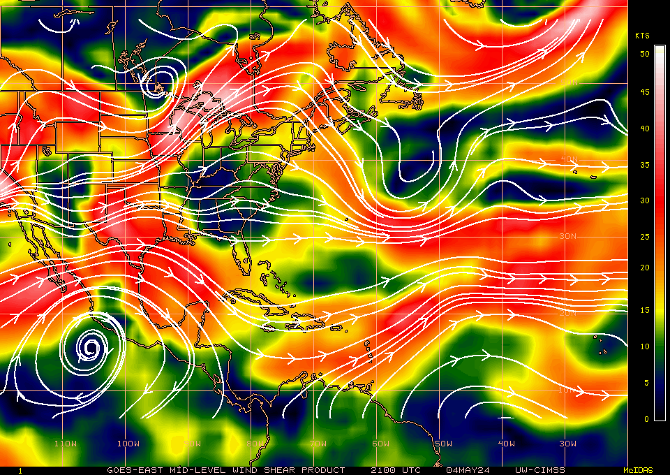
That shear map has had no shear all day
0 likes
-
latemodel25

- Category 1

- Posts: 454
- Joined: Sat Sep 04, 2004 4:15 am
- Location: parrish fl
- Contact:
Re: ATL: Tropical Storm Gustav in Central Caribbean Sea
nope sure didnt.. i must have missed that one. i wonder if the model predicting it to break up "so to speak" missed it too? really weird how all these models have such different analysis. i understand timing is everything but it just seems like such a crap shoot sometimesSquarethecircle wrote:latemodel25 wrote:so good possibility gustav might fizzle out?
Did you or did you not see the wind prob table?
0 likes
-
deltadog03

- Professional-Met

- Posts: 3580
- Joined: Tue Jul 05, 2005 6:16 pm
- Location: Macon, GA
-
jaxfladude
- Category 5

- Posts: 1249
- Joined: Wed Aug 24, 2005 9:36 pm
- Location: Jacksonville, Fla
Re: ATL: Tropical Storm Gustav in Central Caribbean Sea
IMHO it is not a good idea to leave Gustav for dead until NHC/TPC declares it dead...
0 likes

Re: ATL: Tropical Storm Gustav in Central Caribbean Sea
Derek Ortt wrote:RL3AO wrote:latemodel25 wrote:so good possibility gustav might fizzle out?
No. Not really.
you know full well there is a chance this won't make it. It does not have any model support and I'm not about to forecast dissipation, but given the shearit will have o endure for another 12-24 hours, there is at least a 10% chance
That shear map has had no shear all day
Yes its a possibility, but I wouldn't call it a good one. Like you said, 10 to 20%.
0 likes
-
stormchazer

- Category 5
- Posts: 2462
- Joined: Fri Aug 29, 2003 12:00 pm
- Location: Lakeland, Florida
- Contact:
-
LSU2001

- S2K Supporter
- Posts: 1711
- Age: 58
- Joined: Sat Sep 11, 2004 11:01 pm
- Location: Cut Off, Louisiana
Re:
stormchazer wrote:You have got to wonder after all the doomsday scenarios and nashing of teeth, if Gus is not going to fool us all and just go dare I say "poof"! This is why I love watching these storms. There is always the chance of a big suprise.
IMHO, Poof is a very, very good thing. It does look bad tonight but I have seen worse looking systems rebound and rebound quickly. I think we are still very much in a watch and see mode and the next day or so will tell the tale.
Tim
0 likes
-
deltadog03
- Professional-Met
- Posts: 3580
- Joined: Tue Jul 05, 2005 6:16 pm
- Location: Macon, GA

-
Annie Oakley

- Category 5
- Posts: 1103
- Joined: Tue Jul 31, 2007 12:54 pm
- Location: Texas
Re: ATL: Tropical Storm Gustav in Central Caribbean Sea
Derek Ortt wrote:RL3AO wrote:latemodel25 wrote:so good possibility gustav might fizzle out?
No. Not really.
you know full well there is a chance this won't make it. It does not have any model support and I'm not about to forecast dissipation, but given the shearit will have o endure for another 12-24 hours, there is at least a 10% chance
That shear map has had no shear all day
Derek-a 10 percent chance of what-surviving or dissapating?
This is getting confusing...because I believe you are so great at being a Met and I do pay attention to what you say- thanks!
0 likes
-
cheezyWXguy

- Category 5
- Posts: 6282
- Joined: Mon Feb 13, 2006 12:29 am
- Location: Dallas, TX
Re: ATL: Tropical Storm Gustav in Central Caribbean Sea
Well, it does appear that it is trying to absorb the blob south of jamaica attm. Convection is increasing in the southern rainbands with each new frame. The question is, will it be enough to refuel the storm? Personally, I think so, but its going to take a while. We will probably see this maintain at about 40-45mph overnight tonight, and if that convection does eventually wrap into the center, then a strengthening trend will be in store tomorrow. Nonetheless, I have become extremely unsure of the fate of this storm. This seems to be pulling an ernesto right now.
Well, it appears I was right. New convection has just popped up in the vicinity of Gustav's center. 2 blobs of red as more convection flows towards the center from the southwest. It will be a slow process, but I now do believe that Gustav will strengthen again, likely just at the last minute. Shear will likely relax in about 12 hours as the ULL to the NE drops SSE slowly and it may regain hurricane status in about 2 days. Remember people. Once this can reestablish an inner core with convection over the center, there is nothing to stop it from quickly strengthening.
Well, it appears I was right. New convection has just popped up in the vicinity of Gustav's center. 2 blobs of red as more convection flows towards the center from the southwest. It will be a slow process, but I now do believe that Gustav will strengthen again, likely just at the last minute. Shear will likely relax in about 12 hours as the ULL to the NE drops SSE slowly and it may regain hurricane status in about 2 days. Remember people. Once this can reestablish an inner core with convection over the center, there is nothing to stop it from quickly strengthening.
Last edited by cheezyWXguy on Wed Aug 27, 2008 8:31 pm, edited 1 time in total.
0 likes
-
Stormcenter
- S2K Supporter
- Posts: 6689
- Joined: Wed Sep 03, 2003 11:27 am
- Location: Houston, TX
Re: ATL: Tropical Storm Gustav in Central Caribbean Sea
Yeah I know the models are saying Gus is going to be this and that "when" it gets into Carribean and then the GOM. But
let's ALL be honest here it really "continues" to sick. If I didn't know this was Gus I would say it was a wave just lby ooking at it. I mean did the NHC predict this? Did any of the models forecast this?
http://www.ssd.noaa.gov/goes/flt/t1/loop-avn.html
let's ALL be honest here it really "continues" to sick. If I didn't know this was Gus I would say it was a wave just lby ooking at it. I mean did the NHC predict this? Did any of the models forecast this?
http://www.ssd.noaa.gov/goes/flt/t1/loop-avn.html
Last edited by Stormcenter on Wed Aug 27, 2008 8:27 pm, edited 1 time in total.
0 likes
-
Weather Watcher

- Tropical Storm

- Posts: 171
- Joined: Tue Aug 30, 2005 7:03 pm
- Location: Wisconsin
- Contact:
Re: ATL: Tropical Storm Gustav in Central Caribbean Sea
Since it is not looking very good right now should NO declare a state of emergency so soon...
Louisiana Officials Declare State of Emergency in Advance of Gustav
Wednesday, August 27, 2008
http://www.foxnews.com/story/0,2933,411862,00.html
Louisiana Officials Declare State of Emergency in Advance of Gustav
Wednesday, August 27, 2008
http://www.foxnews.com/story/0,2933,411862,00.html
0 likes
-
Blown Away
- S2K Supporter
- Posts: 10253
- Joined: Wed May 26, 2004 6:17 am
Re: ATL: Tropical Storm Gustav in Central Caribbean Sea
HURAKAN, post that pic of Fay when she was a dot and everybody was writing her off. Fay came back from the dead not to become a big cane but a decent system again.
0 likes
-
LAwxrgal

- S2K Supporter
- Posts: 1763
- Joined: Tue Jul 06, 2004 1:05 pm
- Location: Reserve, LA (30 mi west of NOLA)
Re: ATL: Tropical Storm Gustav in Central Caribbean Sea
Stormcenter wrote:Yeah I know the models are saying Gus is going to be this and that "when" it gets into Carribean and then the GOM. But
let's ALL be honest here it really "continues" to sick. If I didn't it was Gus I would say it was a wave just looking at it.
I mean did the NHC predict this? Did any of the models forecast this?
http://www.ssd.noaa.gov/goes/flt/t1/loop-avn.html
Didn't the GFS kinda call this? That Gustav would be weak in the near term?
0 likes
-
Frank P
- S2K Supporter
- Posts: 2779
- Joined: Fri Aug 29, 2003 10:52 am
- Location: Biloxi Beach, Ms
- Contact:
Re:
deltadog03 wrote:I see it clearly moving WSW...About due west of the tip of haiti.
The IR loops I've seen tonight make Gus look quite pitiful. more convection under jamacia than near Gus.. hardly no convection near the center at all ATTM... hard for me to accept that the NHC could nail such a forecast over 5 days out and the direct NOLA hit comes to fruition... got to go either west or east, it just has to, the law of averages has to pan out for the MS coast, we can't get majors every three years, that's insane..... and if not then this would be the greatest hurricane forecast of all times by the NHC or perhaps just lucky... maybe wishful thinking on my part... I've seen panic in many of my friends faces throughout the day.. I am talking real fear, something that I don't think I've ever seen before.. ... some to point of tears.. the MS coast can't take another major, I can't imagine how long this could add to the already slow Katrina recovery... all the hype from the media and local gov't agencies only adds to the pain.. this makes me sick
0 likes
Who is online
Users browsing this forum: No registered users and 58 guests